From Surf Wiki (app.surf) — the open knowledge base
NEXRAD
Network of weather radars operated by the NWS

Network of weather radars operated by the NWS
| Field | Value |
|---|---|
| name | NEXRAD |
| image | 2025-03-04 15 58 38 The Fort Dix WSR-88D NEXRAD radar (KDIX) at Joint Base McGuire–Dix–Lakehurst in Manchester Township, Ocean County, New Jersey.jpg |
| caption | NEXRAD Radar at Fort Dix in New Jersey |
| country | United States |
| introdate | |
| number | 159 in the US, Puerto Rico and Guam plus an additional 3 WSR-88Ds, one in Japan and two in South Korea that are not included in the network |
| type | Weather radar |
| frequency | 2,700 to 3,000 MHz (S band) |
| PRF | 320 to 1,300 Hz (according to VCP) |
| beamwidth | 0.96° with 2.7 GHz |
| 0.88° with 3.0 GHz | |
| pulsewidth | 1.57 to 4.57 μs (according to VCP) |
| RPM | 3 |
| range | 460 km for reflectivity |
| 230 km for Doppler velocity | |
| altitude | |
| diameter | 8.54 m |
| height | |
| width | |
| azimuth | 0 to 360º |
| elevation | -1° to +20° (operations) |
| up to +60° (test) | |
| power | 750 KW |
| other names | WSR-88D |
0.88° with 3.0 GHz 230 km for Doppler velocity up to +60° (test) NEXRAD or Nexrad (Next-Generation Radar) is a network of 159 high-resolution S-band Doppler weather radars operated by the National Weather Service (NWS), an agency of the National Oceanic and Atmospheric Administration (NOAA) within the United States Department of Commerce, the Federal Aviation Administration (FAA) within the Department of Transportation, and the U.S. Air Force within the Department of Defense. Its technical name is WSR-88D (Weather Surveillance Radar, 1988, Doppler).
NEXRAD detects precipitation and atmospheric movement or wind. It returns data which when processed can be displayed in a mosaic map which shows patterns of precipitation and its movement. The radar system operates in two basic modes, selectable by the operator – a slow-scanning clear-air mode for analyzing air movements when there is little or no activity in the area, and a precipitation mode, with a faster scan for tracking active weather. NEXRAD has an increased emphasis on automation, including the use of algorithms and automated volume scans.
Deployment
In the 1970s, the U.S. Departments of Commerce, Defense, and Transportation, agreed that to better serve their operational needs, the existing national radar network needed to be replaced. The radar network consisted of WSR-57 developed in 1957, and WSR-74 developed in 1974. Neither system employed Doppler technology, which provides wind speed and direction information.
The Joint Doppler Operational Project (JDOP) was formed in 1976 at the National Severe Storms Laboratory (NSSL) to study the usefulness of using Doppler weather radar to identify severe and tornadic thunderstorms. Tests over the next three years, conducted by the National Weather Service and the Air Weather Service agency of the U.S. Air Force, found that Doppler radar provided much improved early detection of severe thunderstorms. A working group that included the JDOP published a paper providing the concepts for the development and operation of a national weather radar network. In 1979, the NEXRAD Joint System Program Office (JSPO) was formed to move forward with the development and deployment of the proposed NEXRAD radar network. That year, the NSSL completed a formal report on developing the NEXRAD system.
When the proposal was presented to the Reagan administration, two options were considered to build the radar systems: allow corporate bids to build the systems based on the schematics of the previously developed prototype radar or seek contractors to build their own systems using predetermined specifications. The JSPO group opted to select a contractor to develop and produce the radars that would be used for the national network. Radar systems developed by Raytheon and Unisys were tested during the 1980s. However, it took four years to allow the prospective contractors to develop their proprietary models. Unisys was selected as the contractor, and was awarded a full-scale production contract in January 1990.
| [[Image:NEXRAD map.jpg | thumb | x150px | NEXRAD sites within the Contiguous U.S.]] | [[Image:NEXRAD NON-CONTIGUOUS.jpg | x150px | thumb | NEXRAD sites in Alaska, Hawaii, U.S. territories, and military bases.]] |
|---|
Installation of an operational prototype was completed in the fall of 1990 in Norman, Oklahoma. The first installation of a WSR-88D for operational use in daily forecasting was in Sterling, Virginia on June 12, 1992. The last system deployed as part of the installation program was installed in North Webster, Indiana on August 30, 1997. In 2011, the new Langley Hill NEXRAD was added at Langley Hill, Washington to better cover the Pacific Coast of that area; other radars also filled gaps in coverage at Evansville, Indiana and Ft. Smith, Arkansas, following the initial installations. The site locations were strategically chosen to provide overlapping coverage between radars in case one failed during a severe weather event. Where possible, they were co-located with NWS Weather Forecast Offices (WFOs) to permit quick access by maintenance technicians.
The NEXRAD radars incorporated a number of improvements over the radar systems that were previously in use. The new system provided Doppler velocity, improving tornado prediction ability by detecting rotation present within the storm at different scan angles. It provided improved resolution and sensitivity, enabling operators to see features such as cold fronts, thunderstorm gust fronts, and mesoscale to even storm scale features of thunderstorms that had never been visible on radar. The NEXRAD radars also provided volumetric scans of the atmosphere allowing operators to examine the vertical structure of storms and could act as wind profilers by providing detailed wind information for several kilometers above the radar site. The radars also had a much increased range allowing detection of weather events at much greater distances from the radar site.
WSR-88D development, maintenance, and training are coordinated by the NEXRAD Radar Operations Center (ROC) located on the grounds of the University of Oklahoma Westheimer Airport (KOUN) in Norman, Oklahoma.
The University of Louisiana at Monroe in Monroe, Louisiana operates a "WSR-88D clone" radar that is used by local National Weather Service offices in Shreveport, Little Rock and Jackson to fill gaps in NEXRAD coverage in northeastern Louisiana, southeastern Arkansas and western Mississippi. However, the radar's status as being part of the NEXRAD network is disputed.
Radar properties
A standard WSR-88D operates in the S band, at a frequency of around 2800 MHz, with a typical gain around 53 dB using a center-fed parabolic antenna. The pulse repetition frequency (PRF) varies from 318 to 1300 Hz with a maximum power output of 700 kW at Klystron output, although dependent on the volume coverage pattern (VCP) selected by the operator. All NEXRADs have a dish diameter of 9.1 m (30 ft) and an aperture diameter of 8.5 m (28 ft). Using the predetermined VCPs, NEXRADs have a traditional elevation minimum and maximum ranging from 0.1 to 19.5 degrees, although the non-operational minimum and maximum spans from −1 to +45 degrees. Unlike its predecessor, the WSR-74, the antenna can not be manually steered by the operator. WSR-88D Level I data is the recorded output of the digital receiver. Spatial resolution varies with data type and scan angle – level III data has a resolution of 1 km x 1 degree in azimuth, while super-res level II, (implemented in 2008 nationwide), has a resolution of 250m by 0.5 degrees in azimuth below 2.4 degrees in elevation.
Scan strategies
The NEXRAD radar system continually refreshes its three-dimensional database via one of several predetermined scan patterns. These patterns have differing PRFs to fit the respective use, but all have a constant resolution. Since the system samples the atmosphere in three dimensions, there are many variables that can be changed, depending on the desired output. With all traditional VCPs, the antenna scans at a maximum of 19.5 degrees in elevation, and a minimum of .5, with some coastal sites scanning as low as .2 or lower. Due to the incomplete elevation coverage, a phenomenon known as "The Cone of Silence" is present with all NEXRAD radars. The term describes the lack of coverage directly above the radar sites.
There are currently seven Volume Coverage Patterns (VCP) available to NWS meteorologists, with an eighth in the process of replacing one of the existing seven. Each VCP is a predefined set of instructions that control antenna rotation speed, elevation angle, transmitter pulse repetition frequency and pulse width. The radar operator chooses from the VCPs based on the type of weather occurring:
- Clear Air or Light Precipitation: VCP 31, 32, and 35
- Shallow Precipitation: VCP 35, 112, and 215
- Non-Tropical Convection: VCP 12, 212, and 215
- Tropical System Convection: VCP 212, 215, 112, and 121
| VCP | Scan time (min) | Elevation scans | Elevation angles (°) | Usage | SAILS available? | ||||
|---|---|---|---|---|---|---|---|---|---|
| 12 | 4.2 | 14 | 0.5, 0.9, 1.3, 1.8, 2.4, 3.1, 4, 5.1, 6.4, 8, 10, 12.5, 15.6, 19.5 | Severe weather, including tornadoes, located closer to the radar (within 85 miles for storms traveling up to 55 MPH, but shorter distances for faster-moving precipitation) | Yes (up to three per volume scan) | ||||
| 212 | 4.5 | Severe weather, including tornadoes, over 70 miles away from the radar, or widespread severe convection. Best VCP for MRLE use. Completion time for VCP 212 + 1 SAILS scan is similar to VCP 12 + 2 SAILS scans | |||||||
| 112 | url=https://www.roc.noaa.gov/WSR88D/PublicDocs/NewTechnology/Theory_ConOps_VCP112.pdf | title=Theory and Concept of Operations for Multi-PRF Dealiasing Algorithm's VCP 112 | date=March 19, 2019 | website=National Weather Service | access-date=October 16, 2019}} | Variant of VCP 212 designed for tropical systems and strong, non-severe wind shear events. Uses a combination of MPDA and SZ-2 to form a contiguous velocity display. MRLE use is not possible with this VCP | Yes (up to one per volume scan) | ||
| 215 | 6 | 15 | 0.5, 0.9, 1.3, 1,8, 2.4, 3.1, 4, 5.1, 6.4, 8, 10, 12, 14, 16.7, 19.5 | General-purpose precipitation, including tropical systems capable of producing tornadoes. Most vertical resolution of any VCP | Yes (up to one per volume scan) | ||||
| 121 | 6 | 9 | 0.5, 1.5, 2.4, 3.4, 4.3, 6, 9.9, 14.6, 19.5 | Legacy VCP, originally designed for tropical systems. Has significant gaps in vertical resolution above 6°. Scan strategy ensures 20 rotations in six minutes, heavily wearing antenna mechanical components. Similar completion time to VCP 215. To be replaced by VCP 112 | No | ||||
| 31 | 10 | 5 | 0.5, 1.5, 2.4, 3.4, 4.3 | Long-pulse clear air mode designed for maximum sensitivity. Excellent for detecting light snow or subtle boundaries. Prone to detecting ground clutter. May be prone to detecting virga | No | ||||
| 32 | Short-pulse clear air mode designed for clear air or isolated light rain and/or wintry precipitation. Ideal to use when no precipitation is in the radar range, to reduce wear on antenna mechanical components | No | |||||||
| 35 | 7 | 7 | 0.5, 0.9, 1.3, 1,8, 2.4, 3.1, 4, 5.1, 6.4 | Short-pulse clear air VCP designed for scattered to widespread light to moderate precipitation from non-convective cloudforms, especially nimbostratus. Not recommended for convection, except for pop-up thundershowers produced by Cumulus congestus clouds located 30 miles or more away from the radar | Yes (up to one per volume scan) |
The specific VCP currently in use at each NEXRAD site is available.
Enhancements
Super resolution
Deployed from March to August 2008 with all level II data, the Super Resolution upgrade permitted the capability of the radar to produce much higher resolution data. Under legacy resolution, the WSR-88D provides reflectivity data at 1 km by 1 degree to 460 km range, and velocity data at 0.25 km by 1 degree to a range of 230 km. Super Resolution provides reflectivity data with a sample size of 0.25 km by 0.5 degree, and increase the range of Doppler velocity data to 300 km. Initially, the increased resolution is only available in the lower scan elevations. Super resolution makes a compromise of slightly decreased noise reduction for a large gain in resolution.
The improvement in azimuthal resolution increases the range at which tornadic mesoscale rotations can be detected. This allows for faster lead time on warnings and extends the useful range of the radar. The increased resolution (in both azimuth and range) increases the detail of such rotations, giving a more accurate representation of the storm. Along with providing better detail of detected precipitation and other mesoscale features, Super Resolution also provides additional detail to aid in other severe storm analysis. Super Resolution extends the range of velocity data and provides it faster than before, also allowing for faster lead time on potential tornado detection and subsequent warnings.
Dual polarization
| [[File:Non-Polarimetric Radar.gif | thumb | Non-Polarimetric Radar]] | [[File:Polarimetric Radar.gif | thumb | Polarimetric Radar]] |
|---|
WSR-88D sites across the nation have been upgraded to polarimetric radar, which adds a vertical polarization to the traditional horizontally polarized radar waves, in order to more accurately discern what is reflecting the signal. This so-called dual polarization allows the radar to distinguish between rain, hail, and snow, something the horizontally polarized radars cannot accurately do. Early trials showed that rain, ice pellets, snow, hail, birds, insects, and ground clutter all have different signatures with dual polarization, which could mark a significant improvement in forecasting winter storms and severe thunderstorms. The deployment of the dual polarization capability (Build 12) to NEXRAD sites began in 2010 and was completed by the summer of 2013. The radar at Vance Air Force Base in Enid, Oklahoma was the first operational WSR-88D modified to utilize dual polarization technology. The modified radar went into operation on March 3, 2011.
AVSET
When the NEXRAD system was initially implemented, the radar automatically scanned all scan angles in a Volume Coverage Pattern, even if the highest scan angles were free of precipitation. As a result, in many cases when severe weather was farther from the radar site, forecasters could not provide as timely severe weather warnings as possible. The Automated Volume Scan Evaluation and Termination (AVSET) algorithm helps solve this problem by immediately ending the volume scan when precipitation returns at higher scan angles drop below a set threshold (around 20 dBZ). This can often allow for more volume scans per hour, improving severe weather detection without the need for hardware upgrades AVSET was initially deployed in RPG build 12.3, in Fall of 2011.
SAILS and MESO-SAILS
Main article: MESO-SAILS
One of the primary weaknesses of the WSR-88D radar system was the lack of frequency of base (0.5 degree) scans, especially during severe weather. Forecasters, and TV viewers at home, often had access to images that were four or five minutes old, and therefore had inaccurate information. TV viewers at home could be lulled into a false sense of security that a tornado was farther away from them than it really was, endangering residents in the storm's path. The Supplemental Adaptive Intra-Volume Low-Level Scan (SAILS) technique, deployed with Build 14 in the first half of 2014, allows operators the option to run an additional base scan during the middle of a typical volume scan. With one SAILS cut active on VCP 212, base scans occur about once every two and a half minutes, with more frequent updates if AVSET terminates the volume scan early.
Multiple Elevation Scan Option for Supplemental Adaptive Intra-Volume Low-Level Scan (MESO-SAILS) is an enhancement to SAILS, which allows the radar operator to run one, two or three additional base scans during the course of a volume scan, per the operators request. During June 2013, the Radar Operations Center first tested SAILSx2, which adds two additional low-level scans per volume. It was executed for approximately 4.5 hours and during the testing, an Electronics Technician observed the pedestal/antenna assembly's behavior. No excessive wear was noted. Two days later, SAILSx3 was executed, which added 3 additional low-level scans to a volume. During this 1.5 hour test of SAILSx3, a ROC Radar Hardware Engineer accompanied the ROC Electronics Technician to observe the antenna/pedestal assembly. Again, no excessive wear was noted. MESO-SAILS was deployed with Build 16.1, in spring of 2016.
MRLE
Mid-Volume Rescan of Low-Level Elevations (colloquially known as MRLE) is a dynamic scanning option for the WSR-88D derived from MESO-SAILS, a separate scanning option implemented in NEXRAD RPG 14.0, in the Spring of 2014.
During quasi-linear convective systems (QLCS), colloquially known as squall lines, the detection of mesovortices, which generate at 4,000 to 8,000 feet above ground level, is not always possible with SAILS cuts, as the base 0.5 degree scan travels below the formation of mesovortices at closer distances to the radar. MRLE consecutively scans either the two, three or four lowest scan angles during the middle of a typical volume scan, allowing more frequent surveillance of mesovortex formation during QLCS events. MRLE will be deployed on a non-operational basis in RPG 18.0 in spring of 2018, with possible operational deployment with RPG 19.0, if proven useful or of importance.
Deployment was anticipated by the Radar Operations Center to commence in October 2017, along with the RPG 18.0 build, on a non-operational basis. The scanning option will only be available for use with Volume Coverage Patterns 21, 12, 212, and additionally 215. If proven to be significant in terms of warning dissemination, MRLE will deploy operationally nationwide with RPG 18.0, planned for 2018.
Concept

The concept of MRLE derives from the need of more frequent low-level scans during quasi-linear convective systems (QLCSs). During QLCSs, it is not uncommon for brief and otherwise un-noticeable mesovortices to spawn at points along the line. Due to untimely radar data and time being taken to complete the entire volume, these vortices often spawn without warning or prior notice. With MRLE, the operator has the choice between 2 and 4 low-level scans. Unlike MESO-SAILS, which scans at one angle and can only do up to 3 low-level scans per volume, MRLE scans at 4 possible angles, and can cut into a volume up to 4 times, depending on the operators choice. The angles are as follows, alongside their respective scan frequencies:
- MRLEx2 = 0.5° and 0.9° elevations
- MRLEx3 = 0.5°, 0.9° and 1.3° elevations
- MRLEx4 = 0.5°, 0.9°, 1.3° and 1.8° elevations The operator can not use MESO-SAILS alongside MRLE simultaneously. If one is selected while the other is active, the NEXRAD algorithms will automatically set the other "off".
Service Life Extension Program
Started on March 13, 2013, the Service Life Extension Program (SLEP), is an extensive effort to keep and maintain the current NEXRAD network in working order for as long as possible. These improvements include signal processor upgrades, pedestal upgrades, transmitter upgrades, and shelter upgrades. The program is anticipated to be finished by 2022, which coincides with the beginnings of a nationwide implementation of multi-function phased array radars (see below).
Coverage gaps
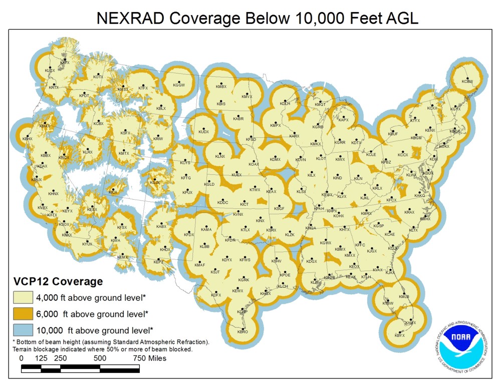
WSR-88D has coverage gaps below 10,000 feet (or no coverage at all) in many parts of the United States, often for terrain or budgetary reasons, or remoteness of the area. Such notable gaps include most of Alaska; several areas of Oregon, including the central and southern coast and much of the area east of the Cascade Mountains; many portions of the Rocky Mountains; Pierre, South Dakota; portions of northern Texas; large portions of the Nebraska panhandle; the Four Corners region; the area around the Northwest Angle in Minnesota; an area near the Connecticut River in Vermont; and areas near the borders of the Oklahoma and Texas Panhandles. Notably, many of these gaps lie in Tornado Alley. At least one tornado has gone undetected by WSR-88D as a result of such a coverage gap – an EF1 tornado in Lovelady, Texas in April 2014. As a result of the coverage gap, initial reports of tornadic activity were treated with skepticism by the local National Weather Service forecast office.
Coverage gaps can also be caused during radar outages, especially in areas with little to no overlapping coverage. For example, a hardware failure on July 16, 2013 resulted in an outage and coverage gap for the Albany, New York area that lasted through early August.
A coverage gap in North Carolina encouraged Senator Richard Burr to propose S. 2058, also known as the Metropolitan Weather Hazard Protection Act of 2015. The act mandates that any city with a population of 700,000 or more must have Doppler Radar coverage
It is not likely that additional WSR-88Ds will be deployed, as the production line was shut down in 1997, and the National Weather Service has an insufficient budget to restart production. In 2011, a known coverage gap was filled when the Langley Hill radar in southwestern Washington was installed. The radar was one of two systems donated to the NEXRAD Program from the U.S. Air Force Keesler AFB Training Center’s NEXRAD Maintenance Course assets. This radar opportunity was spearheaded by a public campaign led by Professor Cliff Mass at the University of Washington, and likely helped the NWS office in Portland, Oregon issue a timely warning for the Manzanita, OR EF-2 tornado in October, 2016.
In 2021, the National Weather Service office in Slidell, Louisiana announced that they would move the office's NEXRAD from the office building in Slidell west to Hammond at the end of 2022. Along with a lower elevation angle, the new location would enable lower level monitoring of storm activity in the Baton Rouge area, where the lowest sampling elevation would drop from 4000-6000 feet above the surface to 300-600 feet.
Destroyed radars
The NEXRAD site located in Cayey, Puerto Rico was destroyed during the passage of Hurricane Maria through the region in September 2017. In addition to a neighboring Terminal Doppler Weather Radar (TDWR) site that was rendered temporarily inoperable but ultimately survived, the Department of Defense deployed two short-range X-band radars on the island to provide radar coverage until the FAA-maintained NEXRAD site was restored. In June 2018, this NEXRAD radar site was restored to fully operational condition and was reinforced with several lightning rods and secured with a stronger fiberglass dome that included using more than 3,000 bolts.
On August 27, 2020, the NEXRAD radar site located in Lake Charles, Louisiana, was destroyed by Hurricane Laura as the eye of the Category 4 storm—which packed wind gusts recorded around 135 mph in the city—passed over the site after it made landfall. NEXRAD radars based in Houston, Shreveport and Fort Polk were used to fill gaps in radar coverage within portions of Southwestern Louisiana until the Lake Charles site was rebuilt; the NWS Radar Operations Center also deployed a SMART-R vehicle on loan from the University of Oklahoma to provide supplemental radar data on Hurricane Delta in advance of its track into the region (nearly paralleling that of Hurricane Laura) in late October. Operational service to the Lake Charles NEXRAD radar site was restored in January 2021, following a four-month, $1.65-million reconstruction project that included the replacement of the radome and internal equipment and repairs to the station's radome pedestal, tower, fence and equipment shelters.
On May 24, 2023, the NEXRAD radar site located on Guam, was damaged by Typhoon Mawar as the eye of the Category 4 typhoon passed over the northern end of the island. After initially being restored back into operation, the installation suffered from ongoing issues and, as of April 24, 2024, has been reported as "unserviceable" in NOTAMs. Future plans for restoring weather radar to Guam and the CNMI are unknown.
Future enhancements
Current NEXRAD system
The National Weather Service keeps a list of upcoming improvements to the WSR-88D system.
Multi-function Phased Array Radar (MPAR)
Main article: Multifunction Phased Array Radar

Beyond dual-polarization, the advent of phased array radar will probably be the next major improvement in severe weather detection. Its ability to rapidly scan large areas would give an enormous advantage to radar meteorologists. Its additional ability to track both known and unknown aircraft in three dimensions would allow a phased array network to simultaneously replace the current Air Route Surveillance Radar network, saving the United States government billions of dollars in maintenance costs. The National Severe Storms Laboratory predicts that a phased array system will eventually replace the current network of WSR-88D radar transmitters.
Applications
Usage
NEXRAD data is used in multiple ways. It is used by National Weather Service meteorologists and (under provisions of U.S. law) is freely available to users outside of the NWS, including researchers, media, and private citizens. The primary goal of NEXRAD data is to aid NWS meteorologists in operational forecasting. The data allows them to accurately track precipitation and anticipate its development and track. More importantly, it allows the meteorologists to track and anticipate severe weather and tornadoes. Combined with ground reports, tornado and severe thunderstorm warnings can be issued to alert the public about dangerous storms. NEXRAD data also provides information about rainfall rate and aids in hydrological forecasting. Data is provided to the public in several forms, the most basic form being graphics published to the NWS website. Data is also available in two similar, but different, raw formats. Available directly from the NWS is Level III data, consisting of reduced resolution, low-bandwidth base products as well as many derived, post-processed products; Level II data consists of only the base products, but at their original resolution. Because of the higher bandwidth costs, Level II data is not available directly from the NWS. The NWS distributes this data freely to Amazon Web Services and several top-tier universities, which in turn distribute the data to private organizations.
Operational locations
| State | |||||
|---|---|---|---|---|---|
| (Abbreviation) | County or Equivalent | City or Place Name | ICAO Location Identifier | Elevation (feet) | Data start date |
| Puerto Rico | Cayey | San Juan | TJUA | 2958 ft | |
| Maine | Aroostook | Houlton | KCBW | 860 ft | |
| Maine | Cumberland | Portland | KGYX | 474 ft | |
| Vermont | Chittenden | Burlington | KCXX | 431 ft | |
| Massachusetts | Bristol | Boston | KBOX | 232 ft | |
| New York | Albany | Albany | KENX | 1935 ft | |
| New York | Broome | Binghamton | KBGM | 1703 ft | |
| New York | Erie | Buffalo | KBUF | 790 ft | |
| New York | Lewis | Griffiss Air Force Base | KRMX | 232 ft | |
| New York | Lewis | Montague | KTYX | 504 ft | |
| New York | Suffolk | New York City | KOKX | 199 ft | |
| Delaware | Sussex | Dover Air Force Base | KDOX | 164 ft | |
| New Jersey | Ocean | Philadelphia | KDIX | 230 ft | |
| Pennsylvania | Allegheny | Pittsburgh | KPBZ | 1266 ft | |
| Pennsylvania | Centre | State College | KCCX | 2486 ft | |
| West Virginia | Kanawha | Charleston | KRLX | 1213 ft | |
| Virginia | Sussex | Norfolk/Richmond | KAKQ | 255 ft | |
| Virginia | Floyd | Roanoke | KFCX | 2965 ft | |
| Virginia | Loudoun | Sterling | KLWX | 404 ft | |
| North Carolina | Carteret | Morehead City | KMHX | 145 ft | |
| North Carolina | Johnston | Raleigh/Durham | KRAX | 462 ft | |
| North Carolina | Brunswick | Wilmington | KLTX | 145 ft | |
| South Carolina | Jasper | Charleston | KCLX | 229 ft | |
| South Carolina | Lexington | Columbia | KCAE | 345 ft | |
| South Carolina | Spartanburg | Greer | KGSP | 1069 ft | |
| Georgia | Fayette | Atlanta | KFFC | 972 ft | |
| Georgia | Lanier | Moody Air Force Base | KVAX | 330 ft | |
| Georgia | Twiggs | Robins Air Force Base | KJGX | 618 ft | |
| Florida | Walton | Eglin Air Force Base | KEVX | 221 ft | |
| Florida | Duval | Jacksonville | KJAX | 160 ft | |
| Florida | Monroe | Key West | KBYX | 89 ft | |
| Florida | Brevard | Melbourne | KMLB | 149 ft | |
| Florida | Miami-Dade | Miami | KAMX | 111 ft | |
| Florida | Leon | Tallahassee | KTLH | 177 ft | |
| Florida | Hillsborough | Tampa | KTBW | 122 ft | |
| Alabama | Shelby | Birmingham | KBMX | 759 ft | |
| Alabama | Dale | Fort Rucker | KEOX | 537 ft | |
| Alabama | Jackson | Huntsville | KHTX | 1859 ft | |
| Alabama | Macon | Maxwell Air Force Base | KMXX | 560 ft | |
| Alabama | Mobile | Mobile | KMOB | 289 ft | |
| Mississippi | Hinds | Jackson | KJAN | 361 ft | |
| Mississippi | Rankin | Jackson/Brandon | KDGX | 609 ft | |
| Mississippi | Monroe | Columbus Air Force Base | KGWX | 609 ft | |
| Tennessee | Hamblen | Morristown | KMRX | 1434 ft | |
| Tennessee | Shelby | Memphis | KNQA | 435 ft | |
| Tennessee | Wilson | Nashville | KOHX | 676 ft | |
| Kentucky | Todd | Fort Campbell | KHPX | 613 ft | |
| Kentucky | Breathitt | Jackson | KJKL | 1461 ft | |
| Kentucky | Hardin | Louisville | KLVX | 833 ft | |
| Kentucky | McCracken | Paducah | KPAH | 506 ft | |
| Ohio | Clinton | Wilmington | KILN | 1170 ft | |
| Ohio | Cuyahoga | Cleveland | KCLE | 860 ft | |
| Michigan | Oakland | Detroit/Pontiac | KDTX | 1216 ft | |
| Michigan | Otsego | Gaylord | KAPX | 1561 ft | |
| Michigan | Kent | Grand Rapids | KGRR | 875 ft | |
| Michigan | Marquette | Marquette | KMQT | 1525 ft | |
| Indiana | Gibson | Evansville | KVWX | 625 ft | |
| Indiana | Marion | Indianapolis | KIND | 887 ft | |
| Indiana | Kosciusko | Fort Wayne | KIWX | 1056 ft | |
| Illinois | Will | Chicago | KLOT | 760 ft | |
| Illinois | Logan | Lincoln | KILX | 731 ft | |
| Wisconsin | Brown | Green Bay | KGRB | 823 ft | |
| Wisconsin | La Crosse | La Crosse | KARX | 1357 ft | |
| Wisconsin | Jefferson | Milwaukee | KMKX | 1023 ft | |
| Minnesota | Saint Louis | Duluth | KDLH | 1542 ft | |
| Minnesota | Carver | Minneapolis | KMPX | 1101 ft | |
| Iowa | Scott | Davenport | KDVN | 851 ft | |
| Iowa | Polk | Des Moines | KDMX | 1095 ft | |
| Missouri | Cass | Kansas City | KEAX | 1092 ft | |
| Missouri | Greene | Springfield | KSGF | 1375 ft | |
| Missouri | Saint Charles | Saint Louis | KSGF | 722 ft | |
| Arkansas | Sebastian | Fort Smith | KSRX | 737 ft | |
| Arkansas | Pulaski | Little Rock | KLZK | 649 ft | |
| Louisiana | Vernon | Fort Polk | KPOE | 473 ft | |
| Louisiana | Tangipahoa | Hammond | KHDC | 144 ft | |
| Louisiana | Calcasieu | Lake Charles | KLCH | 137 ft | |
| Louisiana | Caddo | Shreveport | KSHV | 387 ft | |
| Texas | Potter | Amarillo | KAMA | 3703 ft | |
| Texas | Comal | Austin/San Antonio | KEWX | 767 ft | |
| Texas | Cameron | Brownsville | KBRO | 88 ft | |
| Texas | Nueces | Corpus Christi | KCRP | 142 ft | |
| Texas | Tarrant | Dallas/Fort Worth | KFWS | 777 ft | |
| Texas | Shackelford | Dyess Air Force Base | KDYX | 1582 ft | |
| New Mexico | Doña Ana | El Paso, Texas | KEPZ | 4218 ft | |
| Texas | Williamson | Fort Hood | KGRK | 603 ft | |
| Texas | Galveston | Houston | KHGX | 115 ft | |
| Texas | Kinney | Laughlin Air Force Base | KDFX | 1196 ft | |
| Texas | Lubbock | Lubbock | KLBB | 3378 ft | |
| Texas | Midland | Midland/Odessa | KMAF | 2962 ft | |
| Texas | Tom Green | San Angelo | KSJT | 2004 ft | |
| Oklahoma | Tillman | Altus Air Force Base | KFDR | 1315 ft | |
| Oklahoma | Cleveland | Oklahoma City | KTLX | 1278 ft | |
| Oklahoma | Cleveland | Norman (National Severe Storms Laboratory) | KOUN | 1284 ft | |
| Oklahoma | Cleveland | Norman (Radar Operations Center) | KCRI | 1315 ft | |
| Oklahoma | Rogers | Tulsa | KINX | 749 ft | |
| Oklahoma | Alfalfa | Vance Air Force Base | KVNX | 1258 ft | |
| Kansas | Ford | Dodge City | KDDC | 2671 ft | |
| Kansas | Sherman | Goodland | KGLD | 3716 ft | |
| Kansas | Wabaunsee | Topeka | KTWX | 1415 ft | |
| Kansas | Sedgwick | Wichita | KICT | 1400 ft | |
| Nebraska | Webster | Hastings | KUEX | 2057 ft | |
| Nebraska | Thomas | North Platte | KLNX | 3113 ft | |
| Nebraska | Douglas | Omaha | KOAX | 1262 ft | |
| South Dakota | Brown | Aberdeen | KABR | 1383 ft | |
| South Dakota | Pennington | Rapid City | KUDX | 3195 ft | |
| South Dakota | Minnehaha | Sioux Falls | KFSD | 1495 ft | |
| North Dakota | Burleigh | Bismarck | KBIS | 1755 ft | |
| North Dakota | Traill | Grand Forks | KMVX | 1083 ft | |
| North Dakota | McHenry | Minot Air Force Base | KMBX | 1590 ft | |
| Montana | Yellowstone | Billings | KBLX | 3703 ft | |
| Montana | Valley | Glasgow | KGGW | 2384 ft | |
| Montana | Cascade | Great Falls | KTFX | 3805 ft | |
| Montana | Missoula | Missoula | KMSX | 7978 ft | |
| Wyoming | Laramie | Cheyenne | KCYS | 6193 ft | |
| Wyoming | Fremont | Riverton | KRIW | 5633 ft | |
| Colorado | Adams County | Denver | KFTG | 5611 ft | |
| Colorado | Mesa | Grand Junction | KGJX | 10101 ft | |
| Colorado | Pueblo | Pueblo | KPUX | 5363 ft | |
| New Mexico | Bernalillo | Albuquerque | KABX | 5951 ft | |
| New Mexico | Curry | Cannon Air Force Base | KFDX | 4698 ft | |
| New Mexico | Otero | Holloman Air Force Base | KHDX | 4270 ft | |
| Arizona | Coconino | Flagstaff | KFSX | 7514 ft | |
| Arizona | Maricopa | Phoenix | KIWA | 1426 ft | |
| Arizona | Pima | Tucson | KEMX | 5319 ft | |
| Arizona | Yuma | Yuma | KYUX | 239 ft | |
| Utah | Iron | Cedar City | KICX | 10757 ft | |
| Utah | Box Elder | Salt Lake City | KMTX | 6594 ft | |
| Idaho | Ada | Boise | KCBX | 3172 ft | |
| Idaho | Bingham | Pocatello | KSFX | 4539 ft | |
| Nevada | Lander | Elko | KLRX | 6895 ft | |
| Nevada | Clark | Las Vegas | KESX | 4948 ft | |
| Nevada | Washoe | Reno | KRGX | 8396 ft | |
| California | Butte | Beale Air Force Base | KBBX | 221 ft | |
| California | San Bernardino | Edwards Air Force Base | KEYX | 2873 ft | |
| California | Humboldt | Eureka | KBHX | 2516 ft | |
| California | Ventura | Los Angeles | KVTX | 2807 ft | |
| California | Yolo County | Sacramento | KDAX | 144 ft | |
| California | San Diego | San Diego | KNKX | 1052 ft | |
| California | Santa Clara | San Francisco | KMUX | 3550 ft | |
| California | Kings | San Joaquin Valley | KHNX | 340 ft | |
| California | Orange | Santa Ana Mountains | KSOX | 3106 ft | |
| California | Santa Barbara | Vandenberg Air Force Base | KVBX | 1354 ft | |
| Hawaii | Kauai | South Kauai | PHKI | 340 ft | |
| Hawaii | Hawaii | Kamuela | PHKM | 3966 ft | |
| Hawaii | Maui | Molokaʻi | PHMO | 1444 ft | |
| Hawaii | Hawaii | South Shore | PHWA | 1461 ft | |
| Oregon | Jackson | Medford | KMAX | 7561 ft | |
| Oregon | Umatilla | Pendleton | KPDT | 1580 ft | |
| Oregon | Washington | Portland | KRTX | 1728 ft | |
| Washington | Grays Harbor | Langley Hill | KLGX | 366 ft | |
| Washington | Island | Seattle | KATX | 642 ft | |
| Washington | Spokane | Spokane | KOTX | 2449 ft | |
| Alaska | Bethel | Bethel | PABC | 193 ft | |
| Alaska | Fairbanks North Star | Fairbanks | PAPD | 193 ft | |
| Alaska | Kenai Peninsula | Anchorage | PAHG | 356 ft | |
| Alaska | Bristol Bay | King Salmon | PAKC | 144 ft | |
| Alaska | Chugach | Middleton Island | PAIH | 132 ft | |
| Alaska | Nome | Nome | PAEC | 90 ft | |
| Alaska | Sitka | Sitka | PACG | 272 ft | |
| Guam | Mangilao | Andersen Air Force Base | PGUA | 386 ft | |
| North Jeolla (South Korea) | Kunsan Air Base | RKJK | 192 ft | ||
| Gyeonggi (South Korea) | Camp Humphreys | RKSG | 1521 ft |
Notes
References
- Atlas, David, Radar in Meteorology: Battan Memorial and 40th Anniversary Radar Meteorology Conference, published by the American Meteorological Society, Boston, 1990, 806 pages, , AMS Code RADMET.
References
- Timothy D. Crum. (1993). "The WSR-88D and the WSR-88D Operational Support Facility". Bulletin of the American Meteorological Society.
- Nancy Mathis. (2007). "Storm Warning: The Story of a Killer Tornado". [[Simon & Schuster.
- Tom Banse. (September 29, 2011). "New Weather Radar Heralds More Accurate And Timely Storm Warnings". [[NPR]].
- "WSR-88D Radar, Tornado Warnings and Tornado Casualties". National Oceanic and Atmospheric Administration.
- "An Overview of NEXRAD Products Available via UCAR's Unidata Program". Weather Services International.
- "About the Radar Operations Center (ROC)". [[National Oceanic and Atmospheric Administration]].
- "WSR-88D: Technology Evolution of Level I Data Recording".
- "NEXRAD Technical Information".
- "NEXRAD Technical Information".
- (Oct 22, 2015). "Technical Implementation Notice 15–49 National Weather Service Headquarters Washington DC".
- (Oct 22, 2015). "WSR-88D Volume Coverage Pattern (VCP) Improvement Initiatives". National Weather Service.
- "MESO-SAILS (Multiple Elevation Scan Option for SAILS) Initial Description Document". National Weather Service.
- US Department of Commerce, NOAA. "NWS JetStream MAX - Doppler Radar Volume Coverage Patterns (VCPs)".
- (March 19, 2019). "Theory and Concept of Operations for Multi-PRF Dealiasing Algorithm's VCP 112".
- "Current VCP in use for each Site".
- "RPG SW BUILD 10.0 – INCLUDES REPORTING FOR SW 41 RDA". National Oceanic and Atmospheric Administration.
- "Build10FAQ". National Oceanic and Atmospheric Administration.
- "NEXRAD Product Improvement – Current Status of WSR-88D Open Radar Data Acquisition (ORDA) Program and Plans For The Future". [[American Meteorological Society]].
- "Polarimetric Radar Page". [[University of Oklahoma]].
- (March 7, 2011). "Technical Implementation Notice 10–22 Amended". National Oceanic and Atmospheric Administration.
- "Automated Volume Scan Evaluation and Termination (AVSET)".
- Dennis Mersereau. (June 18, 2014). "This One Little Programming Tweak Will Save Thousands of Lives". [[Gawker.
- "Use of AVSET at RAH during the 16 November 2011 Tornado Event".
- (October 30, 2012). "Supplemental Adaptive Intra-Volume Low-Level Scan (SAILS)".
- Chrisman, Joe. (January 2014). "Multiple Elevation Scan Option for SAILS (MESO-SAILS)".
- "Archived copy".
- "Archived copy".
- (May 2009). "Bow Echo Mesovortices. Part II: Their Genesis".
- (May 12, 2016). "General Description Document Mid-Volume Rescan of Low-Level Elevations (MRLE)".
- "New Radar Technology".
- "mwr2650 1514..1532".
- "Archived copy".
- "Service Life Extension Program (SLEP)".
- "Lovelady, Texas: A Case Study of a Tornadic Cell in a Sparse Radar Coverage Environment". National Oceanic and Atmospheric Administration.
- Nick Wiltgen. (April 16, 2014). "The Tornado East Texas Never Saw Coming – And Why They May Not See The Next One". The Weather Company.
- Dennis Mersereau. (July 25, 2013). "Storms flying under the radar: when radar gaps and down time turn dangerous". [[Washington Post]].
- Burr, Richard. (September 17, 2015). "S.2058 – To require the Secretary of Commerce to study the coverage gaps of the Next Generation Weather Radar of the National Weather Service and to develop a plan for improving radar coverage and hazardous weather detection and forecasting.".
- (2 December 2016). "All Actions S.2058 — 114th Congress (2015–2016)".
- US Department of Commerce, NOAA. "KLIX Radar Is Moving!".
- (September 25, 2017). "Puerto Rico Radar Obliterated After It Takes a Direct Hit From Hurricane Maria". The Weather Channel.
- (31 October 2017). "Federal collaboration yields radar coverage for Puerto Rico, USVI in wake of Hurricane Maria". National Oceanic and Atmospheric Administration.
- (June 18, 2018). "Puerto Rico's Radar Restored 9 Months After Hurricane Maria's Wrath". The Weather Channel.
- Jonathan Erdman. (September 1, 2020). "Hurricane Laura Shredded National Weather Service Radar in Lake Charles, Louisiana". The Weather Company.
- (August 27, 2020). "LCH radar is going to be down a minute.... #Laura -". Brett Adair.
- Ron Brackett. (October 8, 2020). "With Hurricane Delta Approaching, Loaner Radar To Cover For Lake Charles, Louisiana, Station Destroyed by Laura". The Weather Company.
- Jan Wesner Childs. (January 23, 2021). "Lake Charles Radar Back Online After Hurricane Laura Repairs". The Weather Company.
- "Current NOTAMS for PGUA".
- (2014). "New Radar Technologies". National Oceanic and Atmospheric Administration.
- "Multi-Function Phased Array Radar".
- "MIT Lincoln Laboratory: FAA Weather Systems: MPAR".
- "Weather Research: Weather Radar". National Oceanic and Atmospheric Administration.
- "NEXRAD on AWS".
- (27 October 2015). "New AWS Public Data Set – Real-Time and Archived NEXRAD Weather Data {{!}} AWS Blog".
- "Unidata Internet Data Distribution (IDD)".
- "NEXRAD sites and coordinates". [[National Climatic Data Center]].
This article was imported from Wikipedia and is available under the Creative Commons Attribution-ShareAlike 4.0 License. Content has been adapted to SurfDoc format. Original contributors can be found on the article history page.
Ask Mako anything about NEXRAD — get instant answers, deeper analysis, and related topics.
Research with MakoFree with your Surf account
Create a free account to save articles, ask Mako questions, and organize your research.
Sign up freeThis content may have been generated or modified by AI. CloudSurf Software LLC is not responsible for the accuracy, completeness, or reliability of AI-generated content. Always verify important information from primary sources.
Report