From Surf Wiki (app.surf) — the open knowledge base
Neckertal

| Field | Value | ||
|---|---|---|---|
| subject_name | Neckertal | ||
| image_photo | 2011-08-21-Wald Neckertal (Foto Dietrich Michael Weidmann) 282.JPG | ||
| municipality_type | municipality | ||
| imagepath_coa | CHE Neckertal COA.svg | pixel_coa= | |
| imagepath_flag | CHE Neckertal Flag.svg | ||
| canton | St. Gallen | ||
| iso-code-region | CH-SG | ||
| district | Toggenburg | ||
| coordinates | |||
| postal_code | 9105 Wald/Schönengrund | ||
| 9115 Dicken | |||
| 9122 Mogelsberg | |||
| 9123 Nassen | |||
| 9125 Brunnadern | |||
| 9126 Necker | |||
| 9127 St. Peterzell | |||
| 9621 Oberhelfenschwil | |||
| 9633 Hemberg | |||
| municipality_code | 3378 | ||
| area | 49.03 | ||
| elevation | 660 | elevation_description= | |
| population | populationof = | ||
| website | www.neckertal.ch | ||
| mayor | mayor_asof= | mayor_party= | |
| mayor_title | list_of_mayors = | ||
| places | Brunnadern, St. Peterzell, Mogelsberg, Wald-Schönengrund, Nassen, Hoffeld, Ebersol, Dicken, Dieselbach, Necker, Oberhelfenschwil, Hemberg | ||
| neighboring_municipalities | Oberhelfenschwil, Wattwil, Hemberg, Degersheim, Ganterschwil, Lütisburg, Schwellbrunn (AR), Schönengrund (AR) |
| iso-code-region = CH-SG 9115 Dicken 9122 Mogelsberg 9123 Nassen 9125 Brunnadern 9126 Necker 9127 St. Peterzell 9621 Oberhelfenschwil 9633 Hemberg |}} Neckertal is a municipality in the Toggenburg district of the Canton of St. Gallen, Switzerland.
It was formed on January 1, 2009, through the merger of Brunnadern, St. Peterzell, and Mogelsberg. On 1 January 2023 the former municipalities of Hemberg and Oberhelfenschwil merged into the new municipality of Neckertal.
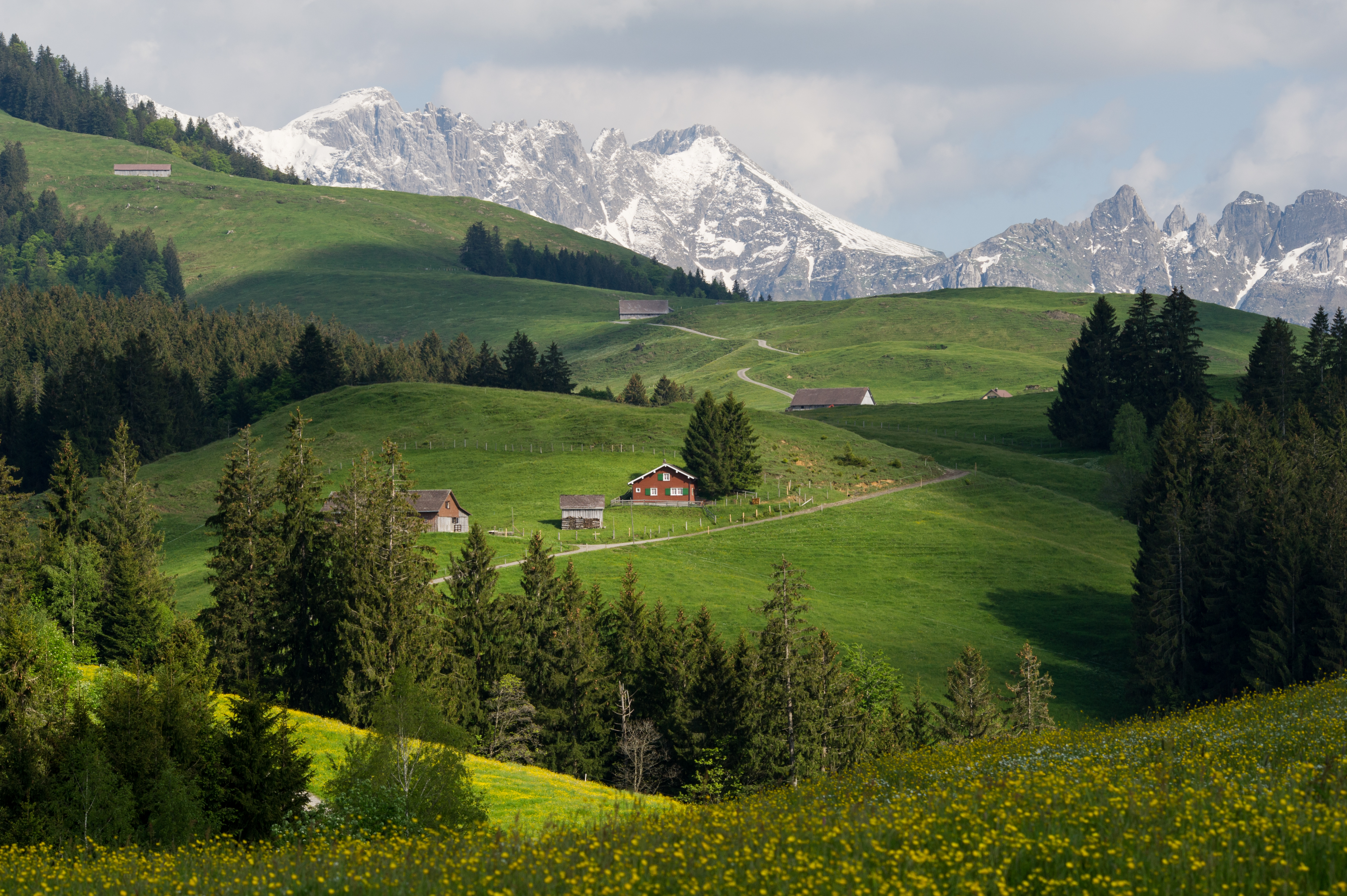
Geography
Neckertal has an area of . As of 2012, a total of 26.17 km2 or 53.4% is used for agricultural purposes, while 19.51 km2 or 39.8% is forested. The rest of the municipality is 2.8 km2 or 5.7% is settled (buildings or roads), 0.29 km2 or 0.6% is either rivers or lakes and 0.23 km2 or 0.5% is unproductive land.
During the same year, housing and buildings made up 3.0% and transportation infrastructure made up 2.0%. A total of 36.9% of the total land area is heavily forested and 2.9% is covered with orchards or small clusters of trees. Of the agricultural land, 51.7% is pasturage and 1.1% is used for alpine pastures. All the water in the municipality is flowing water.
It is made up of the villages of Brunnadern, St. Peterzell, and Mogelsberg as well as the hamlets of Wald-Schönengrund, Dicken, Nassen, Hoffeld, Dieselbach, Ebersol and Necker.
Demographics
Neckertal has a population () of . , 7.9% of the population are resident foreign nationals. Between the last 2 years (2010-2012) the population changed at a rate of -2.0%. Migration accounted for -2.1%, while births and deaths accounted for 0.2%.
Most of the population () speaks German (95.5%) as their first language, French is the second most common (0.2%) and Italian is the third (0.9%).
, children and teenagers (0–19 years old) make up 23.8% of the population, while adults (20–64 years old) make up 60.8% and seniors (over 64 years old) make up 15.3%.
, there were 460 households that consist of only one person and 206 households with five or more people. , the construction rate of new housing units was 0.5 new units per 1000 residents.
there were 1,838 households in the municipality.
Historic population
The historical population is given in the following chart: Colors= id:lightgrey value:gray(0.9) id:darkgrey value:gray(0.8) ImageSize = width: auto height:500 barincrement:45 PlotArea = top:20 left:40 bottom:90 right:35 Legend = columns:3 left:20 top:70 columnwidth:160 AlignBars = justify DateFormat = x.y Period = from:0 till:5300 TimeAxis = orientation:vertical AlignBars = justify ScaleMajor = gridcolor:darkgrey increment:1000 start:0 ScaleMinor = gridcolor:lightgrey increment:200 start:0 Colors= id:BR value:yellowgreen legend:Brunnadern id:ST value:green legend:St._Peterzell id:MO value:blue legend:Mogelsberg PlotData= color:yellowgreen width:30 mark:(line,white) align:center bar:1850 from: 0 till:931 text:"931" color:BR bar:1860 from: 0 till:859 text:"859" color:BR bar:1870 from: 0 till:766 text:"766" color:BR bar:1880 from: 0 till:811 text:"811" color:BR bar:1890 from: 0 till:814 text:"814" color:BR bar:1900 from: 0 till:710 text:"710" color:BR bar:1910 from: 0 till:729 text:"729" color:BR bar:1920 from: 0 till:704 text:"704" color:BR bar:1930 from: 0 till:640 text:"640" color:BR bar:1940 from: 0 till:583 text:"583" color:BR bar:1950 from: 0 till:735 text:"735" color:BR bar:1960 from: 0 till:611 text:"611" color:BR bar:1970 from: 0 till:587 text:"587" color:BR bar:1980 from: 0 till:683 text:"683" color:BR bar:1990 from: 0 till:833 text:"833" color:BR bar:2000 from: 0 till:917 text:"917" color:BR bar:1850 from: 931 till:2124 text:"1,193" color:ST bar:1860 from: 859 till:2112 text:"1,253" color:ST bar:1870 from: 766 till:2071 text:"1,305" color:ST bar:1880 from: 811 till:2074 text:"1,263" color:ST bar:1890 from: 814 till:2180 text:"1,366" color:ST bar:1900 from: 710 till:1982 text:"1,272" color:ST bar:1910 from: 729 till:2015 text:"1,286" color:ST bar:1920 from: 704 till:1880 text:"1,176" color:ST bar:1930 from: 640 till:1722 text:"1,082" color:ST bar:1940 from: 583 till:1606 text:"1,023" color:ST bar:1950 from: 735 till:1742 text:"1,007" color:ST bar:1960 from: 611 till:1525 text:"914" color:ST bar:1970 from: 587 till:1484 text:"897" color:ST bar:1980 from: 683 till:1539 text:"856" color:ST bar:1990 from: 833 till:1995 text:"1,162" color:ST bar:2000 from: 917 till:2173 text:"1,256" color:ST bar:1850 from: 2124 till:4965 text:"2,841" color:MO bar:1860 from: 2112 till:5073 text:"2,961" color:MO bar:1870 from: 2071 till:5021 text:"2,950" color:MO bar:1880 from: 2074 till:5144 text:"3,070" color:MO bar:1890 from: 2180 till:5277 text:"3,097" color:MO bar:1900 from: 1982 till:4759 text:"2,777" color:MO bar:1910 from: 2015 till:4947 text:"2,932" color:MO bar:1920 from: 1880 till:4489 text:"2,609" color:MO bar:1930 from: 1722 till:4136 text:"2,414" color:MO bar:1940 from: 1606 till:3921 text:"2,315" color:MO bar:1950 from: 1742 till:4227 text:"2,485" color:MO bar:1960 from: 1525 till:3930 text:"2,405" color:MO bar:1970 from: 1484 till:3648 text:"2,164" color:MO bar:1980 from: 1539 till:3348 text:"1,809" color:MO bar:1990 from: 1995 till:4174 text:"2,179" color:MO bar:2000 from: 2173 till:4434 text:"2,261" color:MO
Economy
_229.JPG)
, Neckertal had an unemployment rate of 1.51%. , there were a total of 1,531 people employed in the municipality. Of these, there were 374 people employed in the primary economic sector and about 168 businesses involved in this sector. 404 people were employed in the secondary sector and there were 76 businesses in this sector. 753 people were employed in the tertiary sector, with 190 businesses in this sector. Of the working population, 14.5% used public transportation to get to work, and 46.1% used a private car.
In 2012 the average local and cantonal tax rate on a married resident, with two children, of Neckertal making 150,000 CHF was 10.6%, while an unmarried resident's rate was 17.9%. For comparison, the average rate for the entire canton in 2011, was 11.9% and 20.7%, while the nationwide average was 12.3% and 21.1% respectively.
In 2010 there were a total of 1,636 tax payers in the municipality. Of that total, 419 made over 75,000 CHF per year. There were 33 people who made between 15,000 and 20,000 per year. The greatest number of workers, 436, made between 50,000 and 75,000 CHF per year. The average income of the over 75,000 CHF group in Neckertal was 110,379 CHF, while the average across all of Switzerland was 131,244 CHF.
In 2011 a total of 0.0% of the population received direct financial assistance from the government.
Heritage sites of national significance
There are three buildings in Mogelsberg that are listed as Swiss heritage sites of national significance. They are the Haus Näf, the Oberes Türmlihaus and the Unteres Türmlihaus. The entire village of Mogelsberg and the Spreitenbach / Furth area are both part of the Inventory of Swiss Heritage Sites.
File:Neckertal Furt Haus Näf sw.JPG|Haus Näf at Furt 520 File:Neckertal Oberes Türmlihaus so.JPG|Oberes Türmlihaus at Furtstrasse 93 File:Neckertal Unteres Türmlihaus so.JPG|Unteres Türmlihaus at Furtstrasse 95
Politics
In the 2011 federal election the most popular party was the Swiss People's Party (SVP) which received 37.1% of the vote. The next three most popular parties were the Christian Democratic People's Party (CVP) (17.4%), the FDP.The Liberals (13.7%) and the Social Democratic Party (SP) (12.3%). In the federal election, a total of 1,377 votes were cast, and the voter turnout was 46.5%.
Religion
In 2000 about 53.9% of the population belonged to a Protestant church, 31.2% were Roman Catholic and 7.5% had no religious affiliation.
Education
In Neckertal about 51.4% of the population have completed non-mandatory upper secondary education, and 14.5% have completed additional higher education (either university or a Fachhochschule).
References
References
- [http://www.bfs.admin.ch/bfs/portal/de/index/infothek/nomenklaturen/blank/blank/gem_liste/03.html Amtliches Gemeindeverzeichnis der Schweiz] published by the Swiss Federal Statistical Office {{in lang. de accessed 14 January 2010
- [http://www.bfs.admin.ch/bfs/portal/de/index/themen/02/03/blank/data/gemeindedaten.html Swiss Federal Statistical Office-Land Use Statistics] 2009 data {{in lang. de accessed 25 March 2010
- [http://www.bfs.admin.ch/bfs/portal/en/index/regionen/02/key.html Swiss Federal Statistical Office] accessed 8 August 2014
- [http://www.bfs.admin.ch/bfs/portal/de/index/themen/01/04/blank/key/haushaltsgroesse.html Swiss Federal Statistical Office - Haushaltsgrösse] {{webarchive. link. (2014-10-06 {{in lang). de accessed 8 May 2013
- The vacancy rate for the municipality, {{as of. 2013
- [http://www.neckertal.ch/de/portrait/gemeindeinzahlen/ City of Neckertal website-numbers] {{in lang. de accessed 15 January 2010
- link. (2012-03-17 {{in lang). de accessed 29 January 2011
- [http://www.atlas.bfs.admin.ch Statistischer Atlas der Schweiz - Steuerbelastung, 2012 Politische Gemeinden] {{in lang. de accessed 4 August 2014
- [http://www.estv2.admin.ch/d/dokumentation/zahlen_fakten/karten/sb-2011_rangliste/index-d.htm Swiss Federal Tax Administration - Grafische Darstellung der Steuerbelastung 2011 in den Kantonen] {{Webarchive. link. (2013-10-16 {{in lang). de. fr accessed 17 June 2013
- link. (2014-10-06 {{in lang). de. fr accessed 5 August 2014
- [http://www.atlas.bfs.admin.ch Statistischer Atlas der Schweiz - Bezüger/-innen von Sozialhilfeleistungen (Sozialhilfeempfänger/-innen), 2011] accessed 18 June 2013
- [http://www.bevoelkerungsschutz.admin.ch/internet/bs/de/home/themen/kgs/kgs_inventar.html Swiss inventory of cultural property of national and regional significance] {{webarchive. link. (2009-05-01 21.11.2008 version, {{in lang). de accessed 15-Jan-2010
- [http://www.bfs.admin.ch/bfs/portal/de/index/themen/17/02/blank/data/05/03.html Swiss Federal Statistical Office 2011 Election] {{webarchive. link. (2013-11-14 {{in lang). de accessed 8 May 2012
This article was imported from Wikipedia and is available under the Creative Commons Attribution-ShareAlike 4.0 License. Content has been adapted to SurfDoc format. Original contributors can be found on the article history page.
Ask Mako anything about Neckertal — get instant answers, deeper analysis, and related topics.
Research with MakoFree with your Surf account
Create a free account to save articles, ask Mako questions, and organize your research.
Sign up freeThis content may have been generated or modified by AI. CloudSurf Software LLC is not responsible for the accuracy, completeness, or reliability of AI-generated content. Always verify important information from primary sources.
Report