From Surf Wiki (app.surf) — the open knowledge base
Native Bay
Bay in Nunavut, Canada
Bay in Nunavut, Canada
| Field | Value |
|---|---|
| name | Native Bay |
| location | Hudson Bay |
| coords | |
| oceans | Arctic Ocean |
| pushpin_map | Canada Nunavut |
| countries | Canada |
| cities | Uninhabited |
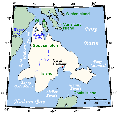
Native Bay is a waterway in the Kivalliq Region, Nunavut, Canada. It is located in Hudson Bay off western Southampton Island. The Bell Peninsula lies to the southeast. Native Point is located at the bay's southern tip. East Bay is 20 km to the east and Coral Harbour is 36 km to the north northwest.
Geography
The habitat consists of three main types, water, unvegetated land, and moist or wet vegetated tundra. This can be further broken down as dry heath, gravel ridge, intertidal zone, moss carpet, scrub willow, and sedge meadow. The elevation rises up to 122 m above sea level.
Climate
Southampton Island has a severe subarctic climate (Köppen Dfc) which transitions into a tundra climate (ET). Like almost all of Nunavut, Southampton Island is entirely above the tree line. Coral Harbour has never gone above freezing in January, February and March (although the latter has recorded 0.0 C. Due to the frozen nature of Hudson Bay, there is a severe seasonal lag until June, especially compared to more continental areas such as Fairbanks despite much sunshine and perpetual twilight at night. Due to the drop of solar strength and the absence of warm water even in summer, temperatures still drop off very fast as September approaches. Cold extremes are severe, but in line with many areas even farther south in Canada's interior.
Fauna
East Bay/Native Bay is a Canadian Important Bird Area (#NU023) and lies just outside of the Qaqsauqtuuq Migratory Bird Sanctuary. Notable bird species include Atlantic brant, colonial water birds, seabirds, common eider, and lesser snow goose.
Caribou frequent the area.
History
An archeological site exists on the west side of Native Point, the largest Sallirmiut site on the island.
Notes
References
References
- {{Cite cgndb. OALKE. Native Bay. (27 May 2024)
- "Southampton Island". oceandots.com.
- (16 February 2021). "Point-to-point distance Native Bay – Coral Harbour". [[Natural Resources Canada]].
- Pickavance, J.R.. (September 2006). "The Spiders of East Bay, Southampton Island, Nunavut, Canada". Arctic.
- "East Bay/Native Bay". bsc-eoc.org.
- "History". edu.nu.ca.
This article was imported from Wikipedia and is available under the Creative Commons Attribution-ShareAlike 4.0 License. Content has been adapted to SurfDoc format. Original contributors can be found on the article history page.
Ask Mako anything about Native Bay — get instant answers, deeper analysis, and related topics.
Research with MakoFree with your Surf account
Create a free account to save articles, ask Mako questions, and organize your research.
Sign up freeThis content may have been generated or modified by AI. CloudSurf Software LLC is not responsible for the accuracy, completeness, or reliability of AI-generated content. Always verify important information from primary sources.
Report