From Surf Wiki (app.surf) — the open knowledge base
National Harbor, Maryland

| Field | Value |
|---|---|
| name | National Harbor |
| settlement_type | Census-designated place |
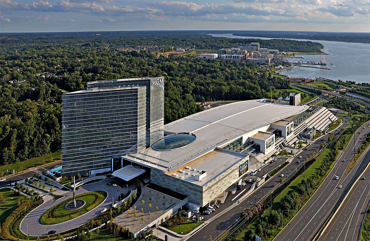
| image_skyline | National_Harbor_Aerial.jpg |
| image_caption | National Harbor in September 2021 |
| image_flag | Flag of National Harbor, Maryland.svg |
| image_blank_emblem | Logo of National Harbor, Maryland.svg |
| blank_emblem_type | Logo |
| pushpin_map | USA Maryland#USA |
| pushpin_label_position | |
| pushpin_map_caption | Location of National Harbor in Maryland |
| map_caption | Location within Prince George's County |
| subdivision_type | Country |
| subdivision_name | United States |
| subdivision_type1 | State |
| subdivision_name1 | Maryland |
| subdivision_type2 | County |
| subdivision_name2 | Flag of Prince George's County, Maryland (1963–present).svg Prince George's |
| subdivision_type3 | Unincorporated area |
| subdivision_name3 | Oxon Hill |
| leader_title | |
| unit_pref | Imperial |
| area_footnotes | |
| area_total_km2 | 4.32 |
| area_land_km2 | 3.30 |
| area_water_km2 | 1.02 |
| population_as_of | 2020 |
| population_total | 5509 |
| population_density_km2 | 1671.28 |
| timezone | Eastern (EST) |
| utc_offset | −5 |
| timezone_DST | EDT |
| utc_offset_DST | −4 |
| coordinates | |
| postal_code_type | ZIP Code |
| postal_code | 20745 |
| area_codes | 301, 240 |
| blank_name | FIPS code |
| blank_info | 24-55018 |
| blank1_name | GNIS ID locale/CDP |
| blank1_info | 2426650/2583665 |
| website | |
| area_total_sq_mi | 1.67 |
| area_land_sq_mi | 1.27 |
| area_water_sq_mi | 0.40 |
| population_density_sq_mi | 4327.57 |
National Harbor is a census-designated place (CDP) in Prince George's County, Maryland, United States, located along the Potomac River near the Woodrow Wilson Bridge and just south of Washington, D.C. It originated as a 300 acre multi-use waterfront development. The population was 5,509 at the 2020 census.
The developer, Peterson Companies, says National Harbor draws 12 million visitors annually, as of 2025.
History
Land use and rezoning
The land developed for National Harbor was previously Salubria Plantation, built in 1827 by Dr. John H. Bayne. The plantation house burned down in 1981 and was offered for sale along with the surrounding land. The land was sold in 1984 and in 1994 was rezoned for mixed-use development. In the fall of 1997, the Maryland Department of the Environment and the Army Corps of Engineers approved new developer permits, granted for the PortAmerica project in 1988.
The National Harbor proposal drew criticism for degrading the surrounding environment. In 1999, the Sierra Club said the project would "prevent forever the completion of the Potomac Heritage Trail".
In 2006, Peterson Companies withdrew plans to build a Target department store where the remaining plantation building, the slave quarters, still stand.
Development

The Gaylord National Resort & Convention Center at National Harbor opened on April 1, 2008 in what was then Oxon Hill, Maryland. Within months of its opening, the site discharged hundreds of thousands of gallons of untreated sewage into the Potomac River.
The site around the Gaylord hotel was developed by Milton Peterson's Peterson Companies. The original plan was to spend over $2 billion and to build from 2007 to late 2014. As of April 2016 construction was continuing and the cost was set at $4 billion.
In 2010, the development was designated as its own census-designated place separate from Oxon Hill.
The Walt Disney Company had announced that it would build a new resort hotel at National Harbor, but backed out of the project in November 2011.
In 2011, Bonnie Bick, a member of the Campaign to Reinvest in the Heart of Oxon Hill suggested preserving the remaining plantation building, and making it a part of a proposed historical loop of the Potomac Heritage National Scenic Trail, as a draw for the development.
The National Children's Museum opened in National Harbor in December 2012. Just over two years later, the museum announced that it would move back to Washington, D.C., and close the Mayland facility.
On November 29, 2012, ground was broken for a Tanger Outlets shopping facility a mile east of the National Harbor waterfront, which opened in November 2013. The Capital Wheel ferris wheel opened in the mid-year of 2014.
An MGM-branded casino, called MGM National Harbor, opened at National Harbor on December 8, 2016, four years after voters approved the expansion of gambling in the state. It was built on the south side of the Beltway, about a mile northeast of the National Harbor waterfront.
On January 12, 2015, Peterson Companies announced that Local Motors planned to open a showroom in National Harbor. On June 17, 2016, it opened to the public and debuted a new vehicle named Olli. Housed in the former site of the children's museum, the showroom includes interactive STEM labs for children and a shop that sells company merchandise.
On October 21, 2023, Titanic: The Exhibition, a museum in National Harbor, was opened to the public. It features sculptures, models, and artifacts from the RMS Titanic.
Facilities

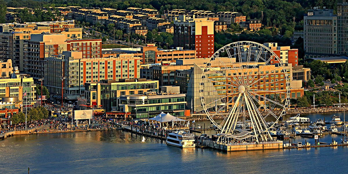
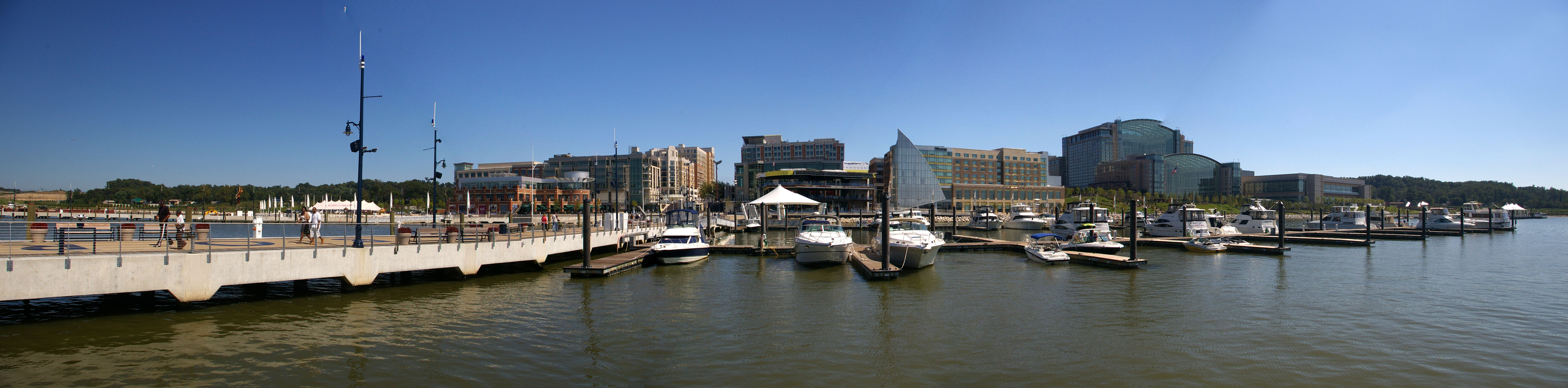
The site has a convention center, six hotels, restaurants, shops, and condominiums. Amusements include a children's carousel, and the Capital Wheel, a 175-foot Ferris wheel on a pier that extends into the Potomac River. There is a fast food restaurant and a gas station among the northern ramps that provide the only ways in or out of National Harbor.
In December 2016, MGM Resorts opened MGM National Harbor, a 300-room hotel as well as a 135,000 sqft casino, stores, a spa, restaurants, a 1,200-seat theater, a 35,000 sqft convention area, and a 5,000 sqft parking garage.
Demographics
|align-fn=center 2010 2020
Melwood first appeared as a census designated place in the 2010 U.S. census formed from part of the Fort Washington CDP.
2020 census
| Race / ethnicity (NH = Non-Hispanic) | title=P2 Hispanic or Latino, and Not Hispanic or Latino by Race – 2010: DEC Redistricting Data (PL 94-171) – National Harbor CDP, Maryland | url=https://data.census.gov/cedsci/table?q=p2&g=1600000US2455018&tid=DECENNIALPL2010.P2 | website=United States Census Bureau}} | title=P2 Hispanic or Latino, and Not Hispanic or Latino by Race – 2020: DEC Redistricting Data (PL 94-171) – National Harbor CDP, Maryland | url=https://data.census.gov/cedsci/table?q=p2&g=1600000US2455018&tid=DECENNIALPL2020.P2 | website=United States Census Bureau}} | % 2010 | % 2020 |
|---|---|---|---|---|---|---|---|---|
| White alone (NH) | 496 | 813 | 13.09% | 14.76% | ||||
| Black or African American alone (NH) | 2,411 | 2,984 | 63.65% | 54.17% | ||||
| Native American or Alaska Native alone (NH) | 4 | 6 | 0.11% | 0.11% | ||||
| Asian alone (NH) | 409 | 437 | 10.80% | 7.93% | ||||
| Native Hawaiian or Pacific Islander alone (NH) | 2 | 2 | 0.05% | 0.04% | ||||
| Other race alone (NH) | 17 | 59 | 0.45% | 1.07% | ||||
| Mixed race or Multiracial (NH) | 93 | 226 | 2.46% | 4.10% | ||||
| Hispanic or Latino (any race) | 356 | 982 | 9.40% | 17.83% | ||||
| Total | 3,788 | 5,509 | 100.00% | 100.00% |
2010 census
As of the census of 2010, there were 3,788 people, 1,598 households, and 868 families residing in the census-designated place. In 2016, prior to the opening of the MGM Casino, an estimated 7,000 staff worked at National Harbor.
Geography
According to the U.S. Census Bureau, National Harbor has a total area of 4.8 sqkm, of which 3.7 sqkm is land and 1.0 sqkm, or 21.7% (consisting of the Potomac River), is water; 300 acres are in the actual development itself.
Access
The only routes in or out of National Harbor are ramps north of the area that link it to Interstate 95/495 (the Capital Beltway), Interstate 295 (Anacostia Freeway), and Oxon Hill Road. Commuters traveling on Indian Head Highway can reach National Harbor using the Oxon Hill Road exits. In 2007, the state spent more than $500 million (~$ in ) to improve roads for the 10,000 cars that were expected to commute daily to National Harbor.
A water taxi line run by the Potomac Riverboat Company connects National Harbor to Alexandria, Virginia. The City of Alexandria also runs shuttles from the water taxi terminal to King Street–Old Town station at an annual cost of about $800,000.
Proposals for Metrorail service
During planning, critics said National Harbor would be too remote from the Washington Metro, the Washington area's rapid transit system. Local civic groups sued National Harbor's developer, then settled in 2004 for promises of investment in the surrounding community and better access to mass transit.
The Woodrow Wilson Bridge, which forms part of the Capital Beltway near National Harbor, was built to handle the addition of a Washington Metro line. No such plans exist. The state of Maryland pays the Washington Metropolitan Area Transit Authority $312,000 annually to operate the NH1 bus line to National Harbor from the Southern Avenue Metro station. In June 2008, the Gaylord National Resort and Convention Center asked the state to fund additional transit service because employees found it difficult to reach National Harbor. In 2011, Metro began considering a rail extension to National Harbor off the Green Line as part of its long-term plan.
The NH2 bus line started running across the Woodrow Wilson Bridge in 2016, connecting with the King Street–Old Town station.
In September 2021, a report on the Blue/Orange/Silver lines recommended converting the Blue Line into a circle line, extending it to National Harbor and Alexandria. In 2022, a NBC4 Washington report suggested the loop might alleviate crowding at the Rosslyn station.
Education
National Harbor is part of the Prince George's County Public Schools district.
Schools serving National Harbor include Fort Foote Elementary School, Oxon Hill Middle School, and Oxon Hill High School.
Gallery

File:Beach area with sculpture of man at National Harbor in Maryland.JPG|The Awakening, an unusual sculpture in National Harbor File:Capital Wheel at National Harbor, Maryland, USA (Lit Up at Night).jpg|Capital Wheel at night File:Items for sale in a candy store in Maryland.JPG|Peeps store File:National Harbor MD Christmas 2011.jpg|A Christmas Tree in National Harbor in 2011 File:View of stores and restaurants at National Harbor in Maryland.JPG|National Harbor stores and restaurants File:Gaylord Resort-Hotel Aerial.jpg|Aerial view of the Gaylord National Resort & Convention Center
Panorama

References
References
- "2020 U.S. Gazetteer Files". United States Census Bureau.
- "National Harbor CDP, Maryland".
- "About National Harbor Waterfront Resort".
- (March 3, 2011). "Forgotten Oxon Hill plantation celebrates county's black heritage, historians say". Post Community Media, LLC.
- (7 January 1998). "National Harbor a threat to the Potomac". Baltimore Sun.
- (April 26, 1999). "The Wilson Crossing: A Better Vision". The Sierra Club, Maryland Chapter.
- (June 1, 2008). "Gaylord National Resort opens". Virginia Business.
- (March 29, 2007). "National Harbor designers envision a bustling attraction". Gazette.
- Zapotosky, Matt. (June 23, 2008). "Residents Blame National Harbor for Sewage Spills". Washington Post.
- "Grand Vision for National Harbor Takes Form". [[The Washington Post]].
- Washington Post, 04apr16, page b1
- {{gnis. 2583665. National Harbor, Michigan
- Heath, Thomas. (November 25, 2011). "In a blow to Prince George's, Disney backs out of National Harbor". The Washington Post.
- (October 7, 2015). "National Children's Museum - Washington, DC". About.
- "Opening day of Tanger Outlets at National Harbor lures shoppers before dawn". [[The Washington Post]].
- (April 20, 2016). "National Harbor: Shop, Dine and Play Along the Potomac". About.
- Wagner, John. (8 May 2013). "MGM confirms plans to bid for Prince George's County casino". Washington Post.
- (12 January 2015). "Local Motors To Open Location at National Harbor - National Harbor". Peterson Companies.
- "Meet Olli, The Driverless Vehicle Cruising Around National Harbor".
- "A Titanic Exhibit Opens at National Harbor Next Month".
- (2011-09-30). "Alexandria Restoration Project". UAC Restoration Group.
- Miller, Stephen. (2009-06-09). "National Harbor to cyclists, pedestrians: Drop dead". Greater Greater Washington.
- "At Maryland's National Harbor, MGM Resorts wants to fit in — and stand out". Las Vegas Review-Journal.
- "Decennial Census of Population and Housing by Decades". [[US Census Bureau]].
- "2010 Census of Population - Population and Housing Unit Counts - Maryland".
- "P2 Hispanic or Latino, and Not Hispanic or Latino by Race – 2010: DEC Redistricting Data (PL 94-171) – National Harbor CDP, Maryland".
- "P2 Hispanic or Latino, and Not Hispanic or Latino by Race – 2020: DEC Redistricting Data (PL 94-171) – National Harbor CDP, Maryland".
- "GENERAL PROFILE 1: PERSONS BY RACE, AGE, AND SEX; URBAN AND RURAL: National Harbor CDP, Maryland". U.S. Census Bureau, American Factfinder.
- Lazo, Luz. (2023-06-05). "Eight years after opening, National Harbor anticipates new life after MGM". Washington Post.
- Wiggins, Ovetta. (2007-06-09). "Direct Access Planned For National Harbor". The Washington Post.
- Downey, Kirstin. (2008-04-01). "Tourism Hopes Riding On Alexandria Trolley". The Washington Post.
- Wiggins, Ovetta. (2004-08-12). "National Harbor Suit Dropped". The Washington Post.
- "Region Needs New Potomac River Bridge". The Huffington Post.
- Wiggins, Ovetta. (2008-06-04). "Gaylord Resort Asks for More Transit Service". The Washington Post.
- "Metro planners contemplate system's second generation".
- Lazo, Luz. (2023-04-11). "Eight years and one casino later, a bus line from Alexandria to National Harbor". Washington Post.
- (September 9, 2021). "Blue/Orange/Silver Capacity & Reliability Study".
- Tuss, Adam. (16 December 2022). "Metro Weighs Building Blue Line Loop to Ease Crowding at Rosslyn, Including Georgetown, National Harbor Stops".
- "[https://www2.census.gov/geo/maps/dc10map/GUBlock/st24_md/place/p2455018_national_harbor/DC10BLK_P2455018_001.pdf 2010 CENSUS - CENSUS BLOCK MAP: National Harbor CDP, MD]." [[U.S. Census Bureau]]. Retrieved on September 2, 2018.
- "[http://gis.pgcps.org/mapgallery/Maps/Boundaries%20-%20Elementary.pdf NEIGHBORHOOD ELEMENTARY SCHOOLS AND BOUNDARIES SCHOOL YEAR 2018-2019]." [[Prince George's County Public Schools]]. Retrieved on September 2, 2018.
- "[http://gis.pgcps.org/mapgallery/Maps/Boundaries%20-%20Middle.pdf NEIGHBORHOOD MIDDLE SCHOOLS AND BOUNDARIES SCHOOL YEAR 2018-2019]." [[Prince George's County Public Schools]]. Retrieved on September 2, 2018.
- "[http://gis.pgcps.org/mapgallery/Maps/Boundaries%20-%20High.pdf NEIGHBORHOOD HIGH SCHOOLS AND BOUNDARIES SCHOOL YEAR 2018-2019]." [[Prince George's County Public Schools]]. Retrieved on September 2, 2018.
This article was imported from Wikipedia and is available under the Creative Commons Attribution-ShareAlike 4.0 License. Content has been adapted to SurfDoc format. Original contributors can be found on the article history page.
Ask Mako anything about National Harbor, Maryland — get instant answers, deeper analysis, and related topics.
Research with MakoFree with your Surf account
Create a free account to save articles, ask Mako questions, and organize your research.
Sign up freeThis content may have been generated or modified by AI. CloudSurf Software LLC is not responsible for the accuracy, completeness, or reliability of AI-generated content. Always verify important information from primary sources.
Report