From Surf Wiki (app.surf) — the open knowledge base
National grassland
Classification of protected and managed federal lands
Classification of protected and managed federal lands

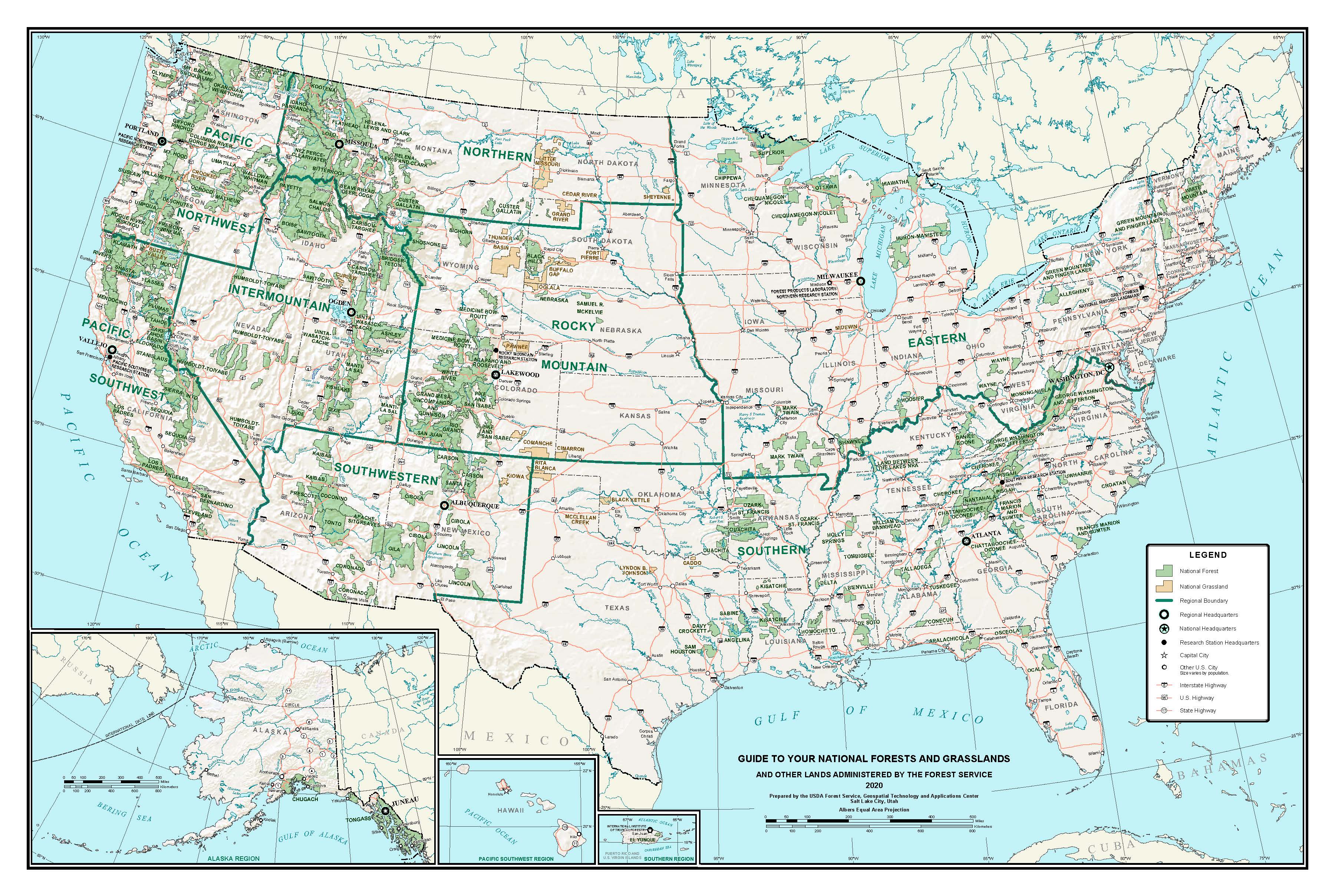
A national grassland is an area of protected and managed federal lands in the United States authorized by Title III of the Bankhead–Jones Farm Tenant Act of 1937 and managed by the United States Forest Service. For administrative purposes, they are essentially identical to national forests, except that grasslands are areas primarily consisting of prairie. Like national forests, national grasslands may be open for hunting, grazing, mineral extraction, recreation and other uses. Various national grasslands are typically administered in conjunction with nearby national forests.
All but four national grasslands are on or at the edge of the Great Plains. Those four are in southeastern Idaho, northeastern California, central Oregon, and a reserve in Illinois. The three national grasslands in North Dakota, together with one in northwestern South Dakota, are administered jointly as the Dakota Prairie Grasslands. National grasslands are generally much smaller than national forests – while a typical national forest would be about 1000000 acre, the average size of a national grassland is 191914 acre. The largest, the Little Missouri National Grassland in North Dakota, covers 1028784 acre, which is approximately the median size of a national forest. As of September 30, 2007, the total area of all 20 national grasslands was 3838280 acre.
Soil Conservation Service
The catastrophic Dust Bowl of the 1930s led to the creation of the Soil Conservation Service in 1933. This and subsequent federal laws paved the way for establishing national grasslands.
List
| Name | Photo | Location | Administered by | Area | Description | Black Kettle | Buffalo Gap | Butte Valley | Caddo | Cedar River | Cimarron | Comanche | Crooked River | Curlew | Fort Pierre | Grand River | Kiowa | Little Missouri | Lyndon B. Johnson | McClellan Creek | Oglala | Pawnee | Rita Blanca | Sheyenne | Thunder Basin |
|---|---|---|---|---|---|---|---|---|---|---|---|---|---|---|---|---|---|---|---|---|---|---|---|---|---|
| [[File:Black Kettle National Grassland.jpg | 150px]] | Oklahoma, Texas | |||||||||||||||||||||||
| Cibola National Forest | 31286 acre | Black Kettle has sandy red slate hills as well as grassland and oak brush. There are three developed recreation areas, and the Washita River flows through the grassland. | |||||||||||||||||||||||
| [[File:Buffalogap Charon.jpg | 150px]] | South Dakota | |||||||||||||||||||||||
| Nebraska National Forests | 595715 acre | There are mixed prairie and badlands in Buffalo Gap as well as a reintroduced population of black-footed ferrets. | |||||||||||||||||||||||
| [[File:ButteValley twotrees.jpg | 150px]] | California | |||||||||||||||||||||||
| Klamath National Forest | 18425 acre | Formed July 1991, Butte Valley is the most recent National Grassland. It contains Meiss Lake and views of the Cascade Range. | |||||||||||||||||||||||
| [[File:Caddo NG red oak.jpg | 150px]] | Texas | |||||||||||||||||||||||
| National Forests and Grasslands in Texas | 17873 acre | Caddo is divided into two units and has two developed recreation areas around Lake Davy Crockett. | |||||||||||||||||||||||
| [[File:Cedar River National Grassland.jpg | 150px]] | North Dakota | |||||||||||||||||||||||
| Dakota Prairie Grasslands | 6717 acre | Cedar River is within the Standing Rock Sioux Reservation and has rolling hills and ephemeral streams. | |||||||||||||||||||||||
| [[File:Cimarron grassland.jpg | 150px]] | Kansas | |||||||||||||||||||||||
| Pike & San Isabel National Forests | 108176 acre | Cimarron has shortgrass prairie with cottonwood groves along the Cimarron River. | |||||||||||||||||||||||
| [[File:Picture Canyon.jpg | 150px]] | Colorado | |||||||||||||||||||||||
| Pike & San Isabel National Forests | 443081 acre | There are not only prairies in Comanche, but also canyons, including Picture Canyon. | |||||||||||||||||||||||
| [[File:Crooked River National Grassland.jpg | 150px]] | Oregon | |||||||||||||||||||||||
| Deschutes & Ochoco National Forests | 112357 acre | Crooked River contains two National Wild and Scenic Rivers: the Deschutes and Crooked rivers. | |||||||||||||||||||||||
| [[File:Mule Deer Curlew.jpg | 150px]] | Idaho | |||||||||||||||||||||||
| Caribou-Targhee National Forest | 47790 acre | In southern Idaho, Curlew provides habitat for sage grouse while the Sweeten Pond area supports waterfowl and shorebirds. | |||||||||||||||||||||||
| [[File:Fort Pierre Grassland pond.jpg | 150px]] | South Dakota | |||||||||||||||||||||||
| Nebraska National Forests | 115890 acre | Located south of Pierre and Fort Pierre, South Dakota, The Fort Pierre grassland includes several ponds open to fishing and dispersed camping. | |||||||||||||||||||||||
| [[File:Grand River NG Lone Tree.jpg | 150px]] | South Dakota | |||||||||||||||||||||||
| Dakota Prairie Grasslands | 154783 acre | In addition to prairie, there are a variety of ecosystems and landforms in Grand River, including sand dunes, river bottoms, badlands, buttes, and sandstone outcroppings. | |||||||||||||||||||||||
| [[File:Kiowa range unit 53.jpg | 150px]] | New Mexico | |||||||||||||||||||||||
| Cibola National Forest | 137131 acre | Kiowa consists of two units in northeastern New Mexico and includes canyons along the Canadian River. | |||||||||||||||||||||||
| [[File:Little Missouri National Grasslands.jpg | 150px]] | North Dakota | |||||||||||||||||||||||
| Dakota Prairie Grasslands | 1028784 acre | The largest National Grassland, Little Missouri includes badlands and short and long grass prairie. | |||||||||||||||||||||||
| [[File:LBJ Grasslands Hillside.jpg | 150px]] | Texas | |||||||||||||||||||||||
| National Forests and Grasslands in Texas | 20309 acre | Used primarily for recreation, Lyndon B. Johnson National Grassland has no fees and is located northwest of Fort Worth. | |||||||||||||||||||||||
| [[File:Lake McClellan.jpg | 150px]] | Texas | |||||||||||||||||||||||
| Cibola National Forest | 1449 acre | McClellan Creek National Grassland surrounds Lake McClellan, and nearly all of the grassland was burned in 2006. | |||||||||||||||||||||||
| [[File:Oglala National Grassland.jpg | 150px]] | Nebraska | |||||||||||||||||||||||
| Nebraska National Forests | 94520 acre | The badlands of Toadstool Geologic Park are within Oglala National Grassland. | |||||||||||||||||||||||
| [[File:Pawnee Buttes2010.jpg | 150px]] | Colorado | |||||||||||||||||||||||
| Arapaho & Roosevelt National Forests | 193060 acre | Pawnee has camping at Crow Valley Recreation Area and trails to the Pawnee Buttes. | |||||||||||||||||||||||
| [[File:Rita Blanca National Grassland.jpg | 150px]] | Texas, Oklahoma | |||||||||||||||||||||||
| Cibola National Forest | 92989 acre | Rita Blanca includes grasslands. | |||||||||||||||||||||||
| [[File:Sheyenne National Grassland.jpg | 150px]] | North Dakota | |||||||||||||||||||||||
| Dakota Prairie Grasslands | 70446 acre | Sheyenne provides habitat for the largest population of greater prairie chickens in North Dakota as well as the Dakota skipper butterfly and western prairie fringed orchid. | |||||||||||||||||||||||
| [[File:Thunder Basin National Grassland Douglas.jpg | 150px]] | Wyoming | |||||||||||||||||||||||
| Medicine Bow – Routt National Forest | 547499 acre | Thunder Basin is located in the Powder River Basin between the Big Horn Mountains and the Black Hills. |
References
References
- "U.S. Board on Geographic Names". [[U.S. Geological Survey]].
- (January 2013). "Land Areas of the National Forest System". U.S. Forest Service.
- (2023-05-25). "The National Grasslands Story".
- {{cite gnis. 1802385. Midewin National Tallgrass Prairie. December 22, 2012
- "Midewin National Tallgrass Prairie".
This article was imported from Wikipedia and is available under the Creative Commons Attribution-ShareAlike 4.0 License. Content has been adapted to SurfDoc format. Original contributors can be found on the article history page.
Ask Mako anything about National grassland — get instant answers, deeper analysis, and related topics.
Research with MakoFree with your Surf account
Create a free account to save articles, ask Mako questions, and organize your research.
Sign up freeThis content may have been generated or modified by AI. CloudSurf Software LLC is not responsible for the accuracy, completeness, or reliability of AI-generated content. Always verify important information from primary sources.
Report