From Surf Wiki (app.surf) — the open knowledge base
Narita, Chiba
| Field | Value | |
|---|---|---|
| name | Narita | |
| native_name | 成田市 | |
| native_name_lang | ja | |
| settlement_type | City | |
| image_skyline | Narita montage.jpg | |
| image_caption | Top: Narita-san Shinshō-ji Temple, Middle left: Narita Sky Access Line, Middle right: Tōshō-ji Temple in Sōgo area, Bottom left: Narita International Airport, Bottom right: Narita Newtown in Karabe area | |
| image_flag | Flag of Narita, Chiba (no text).svg | |
| image_seal | Emblem of Narita, Chiba.svg | |
| image_map | ||
| image_map1 | Narita in Chiba Prefecture Ja.svg | |
| map_caption | Location of Narita in Chiba Prefecture | |
| pushpin_map | Japan | |
| pushpin_label_position | ||
| pushpin_map_caption | ||
| coordinates | ||
| coor_pinpoint | ||
| coordinates_footnotes | tags -- | |
| subdivision_type | Country | |
| subdivision_name | Japan | |
| subdivision_type1 | Region | |
| subdivision_name1 | Kantō | |
| subdivision_type2 | Prefecture | |
| subdivision_name2 | Chiba | |
| established_title | ||
| seat_type | ||
| government_footnotes | tags -- | |
| leader_title | Mayor | |
| leader_name | Kazunari Koizumi | |
| total_type | ||
| unit_pref | ||
| area_magnitude | ||
| area_footnotes | tags -- | |
| area_total_km2 | 213.84 | |
| elevation_footnotes | tags -- | |
| population_footnotes | tags -- | |
| population_total | 131852 | |
| population_as_of | November 30, 2020 | |
| population_density_km2 | auto | |
| population_demonym | ||
| timezone1 | Japan Standard Time | |
| utc_offset1 | +09:00 | |
| area_code_type | ||
| blank_name_sec1 | Phone number | |
| blank_info_sec1 | 0476-22-1111 | |
| blank1_name_sec1 | Address | |
| blank1_info_sec1 | 760 Hanasaki-cho, Narita-shi, Chiba-ken 286-8585 | |
| blank_name_sec2 | Climate | |
| blank_info_sec2 | Cfa | |
| website | ||
| module | {{Infobox place symbols | embedded=yes |
| tree | Ume | |
| flower | Hydrangea |
Narita is a city in Chiba Prefecture, Japan. , the city had an estimated population of 131,852 in 63,098 households and a population density of 620 persons per km2. The total area of the city is 213.84 sqkm. It is the site of Narita International Airport, one of the two main international airports serving the Greater Tokyo Area.
Geography
Narita is located in the northern center of Chiba prefecture, about 25 km from the prefectural capital at Chiba and 50 to from the center of Tokyo. Narita International Airport is about 5 km further from the city center of Narita (the location of the city hall). Located on the Shimosa Plateau, the old town (centered on Narita-san) and the new town are in the southwestern part of the city, and Narita International Airport is in the hills in the southeast. Agricultural areas take water from the Tone River, which runs through the border between Imba-numa in the western part of the city and Ibaraki prefecture on the north. Most of the city is between 10 and above sea level.
Surrounding municipalities
Chiba Prefecture
- Inzai
- Katori
- Kōzaki
- Sakae
- Shibayama
- Shisui
- Tako
- Tomisato Ibaraki Prefecture
- Kawachi
Climate
Narita has a humid subtropical climate (Köppen Cfa) characterized by warm summers and cool winters with light to no snowfall. The average annual temperature in Narita is 14.8 °C. The average annual rainfall is 1498.4 mm with October as the wettest month. The temperatures are highest on average in August, at around 26.0 °C, and lowest in January, at around 3.9 °C.
|Jan record high C = 19.4 |Feb record high C = 24.4 |Mar record high C = 24.9 |Apr record high C = 29.6 |May record high C = 31.3 |Jun record high C = 33.8 |Jul record high C = 38.4 |Aug record high C = 36.9 |Sep record high C = 35.5 |Oct record high C = 32.0 |Nov record high C = 25.3 |Dec record high C = 24.2 |Jan record low C = -8.9 |Feb record low C = -8.9 |Mar record low C = -5.2 |Apr record low C = -2.1 |May record low C = 0.8 |Jun record low C = 7.1 |Jul record low C = 15.0 |Aug record low C = 15.0 |Sep record low C = 8.4 |Oct record low C = 3.0 |Nov record low C = -2.8 |Dec record low C = -8.4 |script-title=ja:観測史上1~10位の値(年間を通じての値) | access-date = April 1, 2022}}{{cite web |script-title=ja:気象庁 / 平年値(年・月ごとの値) | access-date = April 1, 2022}}
Demographics
Per Japanese census data, the population of Narita has recently plateaued after several decades of growth.
| 1950 | 64,370 | 1960 | 61,869 | 1970 | 59,365 | 1980 | 85,897 | 1990 | 105,855 | 2000 | 116,898 | 2010 | 128,933 | 2020 | 132,906
History
The area Narita has been inhabited since the Japanese Paleolithic period. Archaeologists have found stone tools dating to some 30,000 years ago on the site of Narita Airport. Numerous shell middens from the Jōmon period, and hundreds of burial tumuli from the Kofun period have been found in numerous locations around Narita. Place names in the vicinity of Narita appear in the Nara period Man'yōshū (although the name “Narita” does not appear in written records until 1408). As Narita is located roughly equidistant from the Pacific Ocean and Tokyo Bay, around a number of small rivers, it was a natural political and commercial center for the region, and gained importance as a pilgrimage destination with the foundation of the noted Buddhist temple of Shinsho-ji in 940 AD. During the Heian period, the area was a center for the revolt of Taira Masakado. During the Edo period, the area continued to prosper as part of the tenryō within Shimōsa Province under direct control of the Tokugawa shogunate.
After the Meiji Restoration, the area was organized as a town under Inba District on April 1, 1889. Portions of the town were destroyed by Allied air raids in February and May, 1945. On March 31, 1954, Narita gained city status through merger with the neighboring villages of Habu, Nakago, Kuzumi, Toyosumi, Toyama, and Kozu. Growth in the area began in earnest in 1966, when Prime Minister Eisaku Satō laid out the plan for Narita International Airport. The development of the airport and accompanying access to central Tokyo led to widespread residential, commercial and industrial development in the city. However, construction of the airport was widely opposed, and violent demonstrations occurred through the end of the 1960s and early 1970s, which delayed the opening of the airport until May 20, 1978.
On March 27, 2006, the towns of Shimofusa and Taiei (both from Katori District) were merged into Narita.
Government
Narita has a mayor-council form of government with a directly elected mayor and a unicameral city council of 30 members. Narita contributes two members to the Chiba Prefectural Assembly. In terms of national politics, the city is part of the Chiba 10th district of the lower house of the Diet of Japan.
Areas
Central Narita
Central Narita is roughly defined as the area between Narita Station, Keisei Narita Station and the Narita-san Temple. The main road in central Narita is Omotesandō, which is lined with about 150 small shops and has been extensively renovated in recent years.
File:Narita-city-office,japan.jpg|Narita City Hall File:Narita Street in Japan.JPG|The street of Narita-san temple File:Naritasan-Shinshoji-Temple.Great-Main-Hall.jpg|Main Hall of Narita-san temple
Narita New Town
Narita New Town is a planned residential area to the west of Narita Station. It has 16,000 homes with a total population of 60,000. The area was designed in 1968 based on the new towns surrounding London in the UK, and now houses most of the city's population. Many residents of the area are airport or airline workers: the area houses corporate housing and dormitories for Japan Airlines, All Nippon Airways, the Japan Civil Aviation Bureau and Japan Customs. There are also several Urban Renaissance Agency and other government-subsidized housing projects in the area.
File:Narita-gion-festival-1,Narita-city,Japan.jpg|Narita Gion Festival, one of the most famous festivals in Chiba Prefecture, held in July
Kōzunomori
Kōzunomori is a suburban area of Narita located south of the New Town, about 4 minutes by train from Keisei Narita Station. It has a population of about 12,000. Kōzunomori Station is flanked by a large Ito-Yokado department store.
Airport and farm areas
Narita International Airport is located on the east side of Narita in a historically agricultural area called Sanrizuka. The construction and later expansion of the airport led to intense civil unrest among Sanrizuka residents (see Narita International Airport's history). Although land expropriation and poorer farming conditions due to the airport's construction have caused Narita's farming population to drop two-thirds from pre-airport levels, the area immediately surrounding the airport remains lightly populated by farmers.
Industrial areas
There are two main industrial zones in Narita: Nogedaira and Toyosumi. Both zones were laid out in the 1960s to take advantage of Narita Airport and the ability to quickly import and export goods by air. An aircraft part repair plant operated by JAL (Japan Airlines) and Pratt & Whitney, called Japan Turbine Technologies, is located in the Taiei industrial estate.
Economy
Although Narita's economy was historically focused on agriculture, the opening of Narita International Airport refocused the local economy on transportation, logistics and tourism. Most of the airport property is located within Narita City, but many airport hotels and airport-related logistics facilities are in the neighboring towns of Shibayama and Tomisato.
Prologis, FedEx Express, Sagawa Express and several other large logistics firms have major shipping centers in the city.
Nippon Cargo Airlines and Vanilla Air are headquartered on airport property within the city. Spring Airlines Japan is headquartered in the Kozunomori area of the city.
JALways was headquartered in the JAL Operations Center at the airport before merging into JAL in 2010.
Education
Schools
Main article: List of schools in Narita, Chiba
Narita has 24 public and one private elementary schools, one public combined elementary/junior high school, and nine public and one private junior high school. The public schools are under the control of the Narita City Board of Education. The city has four public high schools operated by the Chiba Prefectural Board of Education.
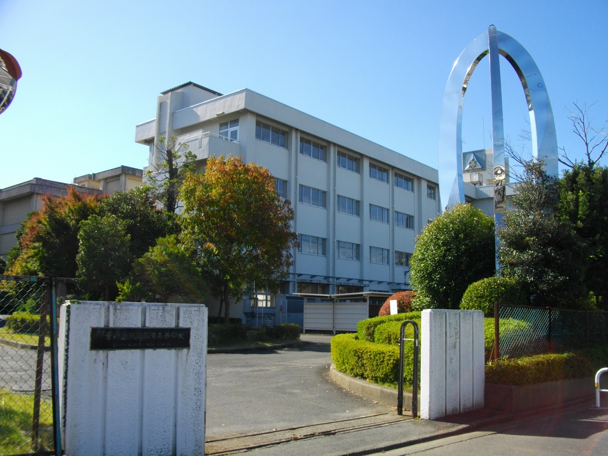
- Narita Kokusai High School
Private schools:
- (成田高等学校・付属中学校)
Public libraries
The City of Narita operates the Narita Public Library. In addition each community center includes a library branch.
Transportation
Airport

- Narita International Airport provides domestic and international services.
Railway
JR East Narita Express trains and Keisei Skyliner trains connect Narita Airport to central Tokyo.

- ––
- –
- ––
- –––
- –
- ––
Highway
The Higashi-Kantō Expressway connects Narita to Tokyo and Chiba City. Chiba Kotsu and Narita Kuko Kotsu provide bus service through the city. The Narita City Loop Bus, operated by both companies, operates on two circular routes around the city, stopping in major commercial areas and at all major hotels.
Sister cities
Narita is twinned with:
- NZL Foxton, New Zealand, since 1995
- USA San Bruno, United States, since 1990
Friendship cities
- KOR Jeongeup, North Jeolla, South Korea, since 2002
- KOR Jung District, Incheon, South Korea, since 1998
- DEN Næstved, Denmark, since 2003
- PRC Xianyang, Shaanxi, China, since 1988
Local attractions

- Chiba Prefectural Boso Fudoki-no-oka Museum
- Narita Peace Pagoda
- Narita-san Shinsho-ji Temple
- Narita Wholesale Market
- Shiseki Park
Notable people
- Yuji Funayama, professional footballer
- Yusuke Igawa, professional footballer
- Yoshio Inaba, actor
- Manabu Iwadate, professional baseball player
- Yuki Karakawa, professional baseball player
- Takeharu Kunimoto, musician
- Yōko Oginome, singer
- Sakura Sōgorō, Edo period folk hero
References
References
- "Narita city official statistics".
- [https://www.citypopulation.de/php/japan-chiba.php Narita population statistics]
- "[http://www.vanilla-air.com/en/corporate/corporate-profile Corporate Profile]." ([https://archive.today/20140119230629/http://www.vanilla-air.com/en/corporate/corporate-profile Archive]) Vanilla Air. Retrieved on January 19, 2014. "Headquarters Narita International Airport 2PTB, Chiba, JAPAN" - [http://www.vanilla-air.com/corporate/corporate-profile Address in Japanese] ([https://archive.today/20140119230819/http://www.vanilla-air.com/corporate/corporate-profile Archive]): "成田国際空港 第2旅客ターミナル内" (Narita International Airport, inside Passenger Terminal 2)
- "[http://www.nca.aero/e/profile/company/about/index.html Corporate Profile]." [[Nippon Cargo Airlines]]. Retrieved on February 17, 2012. "NARITA OFFICE NCA Line Maintenance Hangar Narita International Airport Narita-shi, Chiba 282-0011, Japan" and "TOKYO OFFICE : Onarimon Yusen Bldg. 11F 3-23-5 Nishi-Shimbashi Minato-ku, Tokyo 105-0003, Japan"
- "[https://web.archive.org/web/20081219104422/http://www.jalways.co.jp/english/company/index.html Company Profile]" ([https://archive.today/20081219104422/http://www.jalways.co.jp/english/company/index.html Archive]) JALways. Retrieved on December 12, 2009. "Registered Office 4-11, Higashi-Shinagawa 2-chome,Shinagawa-ku, Tokyo, Japan Head Office Japan Airlines Narita Operation Center 3F, Narita International Airport, Narita, Chiba,Japan 282-8610" [https://web.archive.org/web/20090830075357/http://www.jalways.co.jp/company/index.html Japanese address] ([https://archive.today/20090830075357/http://www.jalways.co.jp/company/index.html Archive]): Registered office: "本店所在地 東京都品川区東品川2丁目4番11号" Headquarters: 〒282-8610 千葉県成田市成田国際空港内 日本航空成田オペレーションセンター3階."
- "Libraries and Community Centers". City Narita, Chiba, Japan.
- link. Narita
This article was imported from Wikipedia and is available under the Creative Commons Attribution-ShareAlike 4.0 License. Content has been adapted to SurfDoc format. Original contributors can be found on the article history page.
Ask Mako anything about Narita, Chiba — get instant answers, deeper analysis, and related topics.
Research with MakoFree with your Surf account
Create a free account to save articles, ask Mako questions, and organize your research.
Sign up freeThis content may have been generated or modified by AI. CloudSurf Software LLC is not responsible for the accuracy, completeness, or reliability of AI-generated content. Always verify important information from primary sources.
Report