From Surf Wiki (app.surf) — the open knowledge base
Mulholland Highway
Road in Los Angeles, United States
Road in Los Angeles, United States
| Field | Value | |||||
|---|---|---|---|---|---|---|
| name | Mulholland Highway | |||||
| image | Mulholland Drive.png | |||||
| caption | Map of Mulholland Drive (orange) and Mulholland Highway (brown) in Los Angeles County | |||||
| image_size | 350 | |||||
| namesake | William Mulholland | |||||
| tourist | [[File:California Scenic.svg | 28px | link=State Scenic Highway System (California)]] Portions of Mulholland Highway | |||
| direction_a | West | |||||
| terminus_a | ||||||
| junction | {{plainlist | |||||
| * {{Jct | state | CA | SR | 23 | dir1=south | name1=Decker Canyon Road}} |
| * {{Jct | state | CA | SR | 23 | dir1=north | name1=Westlake Blvd}} |
| {{Jct | state | CA | CR | N9 | name1=Kanan Road/Kanan Dume Road}} | |
| * {{Jct | state | CA | CR | N1 | name1=Las Virgenes Road}} | |
| direction_b | East | |||||
| terminus_b | /Mulholland Drive |
the highway west of Calabasas
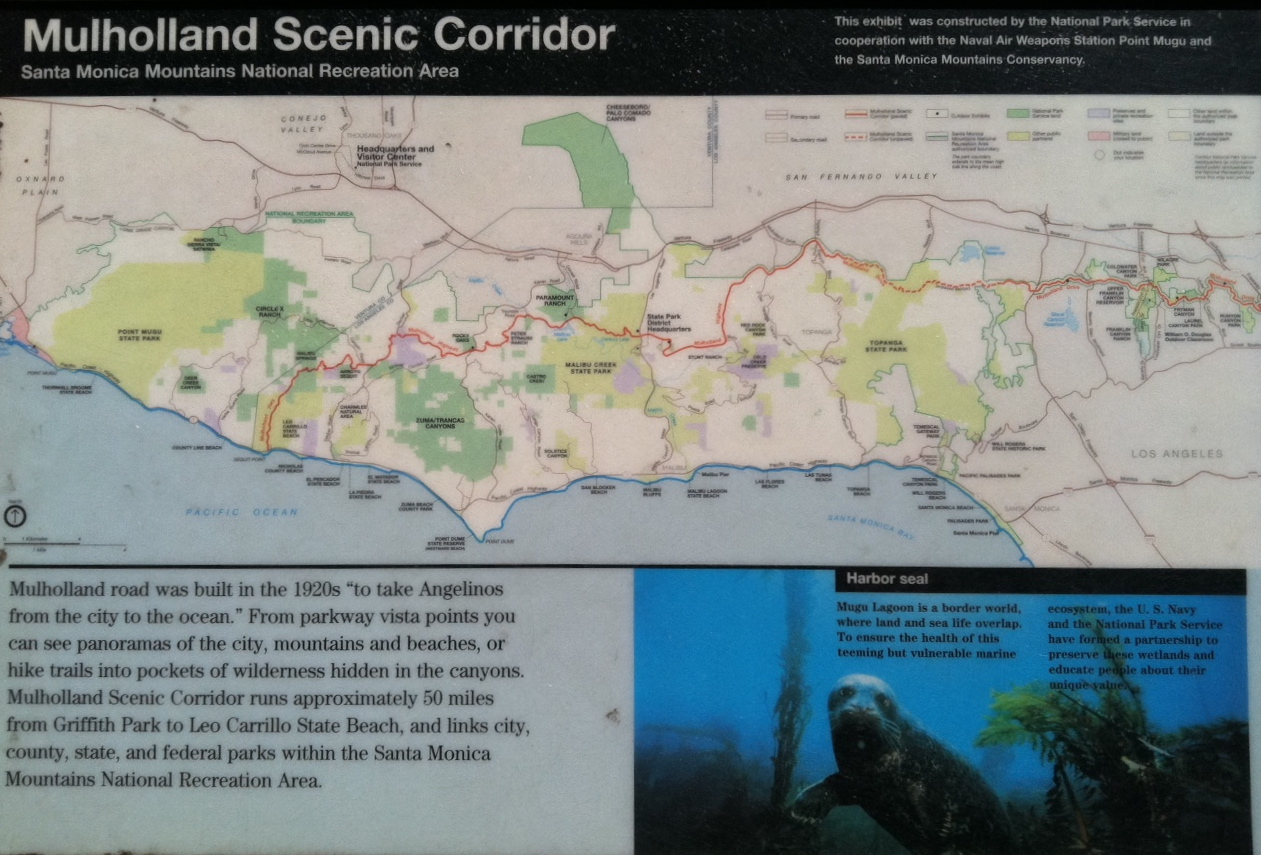
Mulholland Highway is a scenic road in Los Angeles County, California, that runs approximately 50 mi through the western Santa Monica Mountains from near US Route 101 (Ventura Freeway) in Calabasas to Highway 1 (Pacific Coast Highway) near Malibu at Leo Carrillo State Park and the Pacific Ocean coast – at the border of Los Angeles and Ventura Counties.
Mulholland Highway is the western rural portion and, with the eastern Mulholland Drive portion, is a scenic route named after Los Angeles civil engineer William Mulholland and built throughout the 1920s "to take Angelenos from the city to the ocean".
Only the segment of Mulholland Highway between Pacific Coast Highway and Kanan Road/Kanan Dume Road, and through Malibu Creek State Park between Cornell Road and Las Virgenes Road, is officially recognized by the California Department of Transportation as under the California Scenic Highway System, meaning that it is a substantial section of highway passing through a "memorable landscape" with no "visual intrusions", where the potential designation has gained popular favor with the community.
Geography
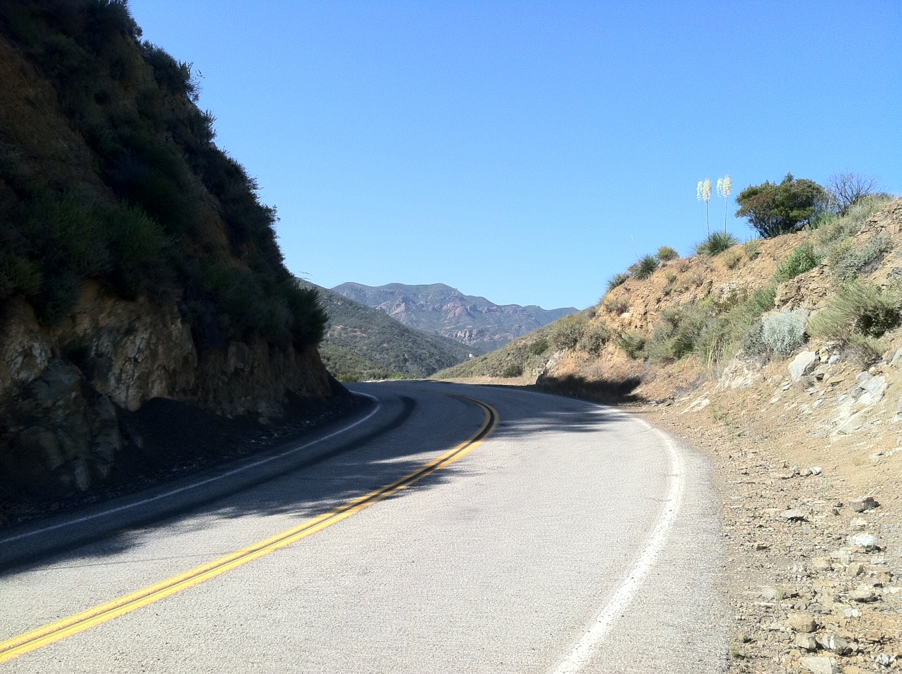
The name Mulholland Highway applies to a 30 mi stretch that starts near Louisville High School (California) in Woodland Hills and extends to its westernmost terminus at Leo Carrillo State Park on the Pacific Coast Highway. Wholly contained within Los Angeles County, the scenic byway was formally opened in 1928. Mulholland zigzags through the Santa Monica Mountains – one of the Southern California Transverse Ranges – from Oxnard all the way to Hollywood. Original major intersections included Topanga Canyon Boulevard, Cornell Road, Latigo Canyon Road, Kanan Road/Kanan Dume Road, and Decker Canyon Road.
The route provides access, directly or en route, to many of the regional parks in the Santa Monica Mountains National Recreation Area.
Running east–west along the spine of the Santa Monicas, Mulholland Highway makes its way through the mountains without benefit of tunnels. There are several automobile wrecks and fire-burnt structures that litter the bottoms of the canyons through which Mulholland Highway passes . The native flora of the Santa Monica Mountains are seen throughout the scenic route.
Hollywoodland
East of US 101, there is a section of Mulholland Highway from the Hollywoodland neighborhood to Griffith Park, with views of the Hollywood Sign. Much of it is now a pedestrian trail called Mulholland Trail.
References
References
- California Department of Transportation. "List of Officially Designated County Scenic Highways". California Department of Transportation.
- {{Caltrans scenic info
This article was imported from Wikipedia and is available under the Creative Commons Attribution-ShareAlike 4.0 License. Content has been adapted to SurfDoc format. Original contributors can be found on the article history page.
Ask Mako anything about Mulholland Highway — get instant answers, deeper analysis, and related topics.
Research with MakoFree with your Surf account
Create a free account to save articles, ask Mako questions, and organize your research.
Sign up freeThis content may have been generated or modified by AI. CloudSurf Software LLC is not responsible for the accuracy, completeness, or reliability of AI-generated content. Always verify important information from primary sources.
Report