From Surf Wiki (app.surf) — the open knowledge base
Mount Kenya
Highest mountain in Kenya

Highest mountain in Kenya
| Field | Value | ||
|---|---|---|---|
| name | Mount Kenya | ||
| elevation_m | 5199 | ||
| elevation_ref | |||
| prominence_m | 3825 | ||
| prominence_ref | |||
| Ranked 32nd | |||
| listing | Seven Second Summits | ||
| Country high point | |||
| Ultra | |||
| map | Kenya | ||
| map_size | 2560 | ||
| location | Kenya | ||
| coordinates | |||
| coordinates_ref | |||
| topo | Mount Kenya by Wielochowski and Savage | ||
| formed_by | Volcanism along the Gregory Rift | ||
| type | Stratovolcano (extinct) | ||
| last_eruption | 2.6–3.1 MYA | ||
| first_ascent | 13 September 1899 by Mackinder, Ollier, and Brocherel, although the peoples of Kenya believed God resided on this mountain and regularly ascended the peaks to perform spiritual rites.{{cite book | ||
| last | Kenyatta | first=Jomo | author-link=Jomo Kenyatta |
| title | Facing Mount Kenya | year=1961 | |
| publisher | Secker and Warburg | location=London | |
| isbn | 978-0-435-90219-3}} | ||
| easiest_route | Rock climb |
Ranked 32nd Country high point Ultra Mount Kenya known by several ancient and indigenous names (Maasai:Ol Donyo Keri, Kalenjin: Koilegen (or Koi-leken), Meru: Kĩrĩmaara, Kikuyu: Kĩrĩmanyaga, (or Kīrī-nyaga), Kamba: Ki nyaa, Embu: Kĩ nyaga) is the second-highest peak in Africa, after Kilimanjaro. The highest peaks of the mountain are Batian (5199 m), Nelion (5188 m) and Point Lenana (4985 m). Mount Kenya is located in the former Eastern and Central provinces of Kenya; its peak is now the intersection of Meru, Embu, Kirinyaga, Nyeri and Tharaka Nithi counties, about 16.5 km south of the equator, around 150 km north-northeast of the capital Nairobi.
Mount Kenya is a volcano created approximately 3 million years after the opening of the East African Rift.{{cite web
There are several vegetation bands from the base to the peak.{{cite book |author-link= Mike Resnick |url-access= registration The lower slopes are covered by different types of forest. Many alpine species are endemic to Mount Kenya, such as the giant lobelias and senecios and a local subspecies of rock hyrax.{{cite book
Mount Kenya National Park
Main article: Mount Kenya National Park
Mount Kenya National Park, established in 1949, protects the region surrounding the mountain. Currently, the national park is within the forest reserve which encircles it. In April 1978 the area was designated a UNESCO Biosphere Reserve.{{cite web |access-date= 6 November 2016 |access-date= 23 February 2008 |archive-url= https://web.archive.org/web/20061230202343/https://whc.unesco.org/pg.cfm?cid=31&id_site=800 |archive-date= 30 December 2006
The Government of Kenya had four reasons for creating a national park on and around Mount Kenya. These were the importance of tourism for the local and national economies, preserving an area of great scenic beauty, conserving the biodiversity within the park, and preserving the water catchment for the surrounding area.{{cite journal |url-status = dead |archive-url = https://web.archive.org/web/20051231095818/http://www.ambio.kva.se/ |archive-date = 31 December 2005
Kenya's government has announced a project to discourage animals from straying into small holdings surrounding the national park and devastating crops, which will see the national park enclosed by an electric fence with five electrified strands. Kenya's Rhino Ark Trust, a non-profit organization, has been putting up fences in key areas around the country. As of 2021, 250 kilometres (160 miles) out of a planned 450 kilometres (280 miles) have been constructed in the Mt. Kenya area. The fence discharges an electric shock, but is not dangerous to humans or animals.
Timeline Breakdown of Mount Kenya Inhabitants
Mount Kenya is a significant cultural landmark for various ethnic communities. The mountain was inhabited by other indigenous peoples long before the arrival of today's major ethnic communities.
| Bantu Groups (Kikuyu, Meru, Embu) | 1000 AD – 1500 AD | These groups arrived in waves during the Great Bantu Migration. They gradually settled the slopes of Mount Kenya, acquiring land and cultural practices (like circumcision) from the earlier indigenous Nilotic groups. |
|---|
Geology

Mount Kenya is a stratovolcano that was active in the Plio-Pleistocene. The original crater was probably over 6000 m high; and potentially up to 7000 m high, making the prehistoric Mount Kenya higher than present-day Kilimanjaro. Since it became extinct there have been two major periods of glaciation, which are shown by two main rings of moraines below the glaciers. The lowest moraine is found at around 3300 m. Today the glaciers reach no lower than 4650 m. After studying the moraines, John Walter Gregory put forward the theory that at one time the whole summit of the mountain was covered with an ice cap, and it was this that eroded the peaks to how they are today. | author-link = John Walter Gregory
The lower slopes of the mountain have never been glaciated. They are now mainly cultivated and forested. They are distinguished by steep-sided V-shaped valleys with many tributaries. Higher up the mountain, in the area that is now moorland, the valleys become U-shaped and shallower with flatter bottoms. These were created by glaciation.
When Mount Kenya was active there was some satellite activity. The northeastern side of the mountain has many old volcanic plugs and craters. The largest of these, Ithanguni, even had its own ice cap when the main peaks were covered in ice. This can be seen by the smoothed summit of the peak. Circular hills with steep sides are also frequent in this area, which are probably the remains of small plugged vents. However, as the remaining mountain is roughly symmetrical, most of the activity must have occurred at the central plug.
The rocks that form Mount Kenya are mainly basalts, rhomb porphyrites, phonolites, kenytes and trachytes. Kenyte was first reported by Gregory in 1900 following his study of the geology of Mount Kenya.{{cite journal | author-link = John Walter Gregory
The geology of the Mount Kenya area was first described scientifically by Joseph Thomson in 1883. He saw the mountain from the nearby Laikipia Plateau and wrote that it was an extinct volcano with the plug exposed.{{cite book | author-link= Joseph Thomson (explorer)
Peaks

The peaks of Mount Kenya are almost all of volcanic origin. The majority of the peaks are located near the centre of the mountain which have an Alpine appearance due to their craggy nature. Typically of Alpine terrain, the highest peaks and gendarmes occur at the intersection of ridges. The central peaks only have a few mosses, lichens, and small alpine plants growing in rock crevices. Further away from the central peaks, the volcanic plugs are covered in volcanic ash and soils.{{cite journal
The highest peaks are Batian (5199 m), Nelion (5188 m) and Pt Lenana (4985 m). Batian and Nelion are within 250 m of each other, separated by the Gate of the Mists gap of 5144 m.
Other peaks around the central plug include Pt Piggot (4957 m), Pt Dutton (4885 m), Pt John (4883 m), Pt John Minor (4875 m), Krapf Rognon (4800 m), Pt Peter (4757 m), Pt Slade (4750 m) and Midget Peak (4700 m). All of these have a steep pyramidal form.
Significant craggy outlying peaks include Terere (4714 m) and Sendeyo (4704 m) which form a pair of twin peaks to the north of the main plug. Together, they form a large parasitic plug. Other notable peaks include The Hat (4639 m), Delamere Peak, Macmillan Peak and Rotundu.
File:Batian Nelion and pt Slade in the foreground Mt Kenya.JPG|Batian on the left, Nelion on the right, and Slade in the foreground File:Pt_Lenana_Mt_Kenya.JPG|Lenana, the third highest peak, is the most ascended File:Mount Kenya Lenana Nelion Batian.jpg|Mount Kenya, left to right: Point Lenana (4985m), Nelion summit (5188), Batian summit (5199m) File:Krapf rognon and glacier after snowstorm.jpg|Krapf Rognon (4800 m) and Krapf glacier File:Hut_tarn_4500m_and_Midget_Peak_Mt_Kenya.JPG|Midget peak can be climbed in a day. File:Terere and Sendeyo.jpg|Terere and Sendeyo are two craggy outlying peaks File:Mugi_hill_and_giants_billards_table.jpg|Mugi hill and the Giant's Billiards Table offers some of the best hillwalking in Kenya. File:Batian.jpg|Nelion from Batian in Dec 1974 File:Point john from top.jpg|Looking down the Diamond Glacier to Pt John
Glaciers

The glaciers on Mount Kenya are retreating rapidly. The Mountain Club of Kenya in Nairobi has photographs showing the mountain at the time of the first recorded ascent in 1899, and again more recently; the retreat of the glaciers is very evident.{{cite web | access-date=26 May 2007 }}Recession of Equatorial Glaciers. A Photo Documentation , Hastenrath, S., 2008, Sundog Publishing, Madison, WI, , 144 pp. Descriptions of ascents of several of the peaks advise the use of crampons, but this is true only in some cases and at higher elevations. Every year there is less new snow accumulating in winter than melting in summer, even on the Lewis Glacier (the largest of them) in winter, so there is no formation of new ice. It is predicted to be less than 30 years before there will no longer be ice on Mount Kenya. Glacial retreat and disappearance can be caused by changes in temperature trends, or by a change in precipitation trends.{{cite book
The glacier names are (clockwise from the north):
- Northey, Krapf, Gregory, Lewis, Diamond, Darwin, Forel, Heim, Tyndall, Cesar, Josef.
The total area covered by glaciers on the mountain was recorded as about 0.7 km2 in the 1980s, far less than that recorded by the first observations, made in the 1890s. A 2024 study showed that only 10% of the surface-area of the 1980s remained; 6,9 ha, about half as much as in 2016.
Periglacial landforms
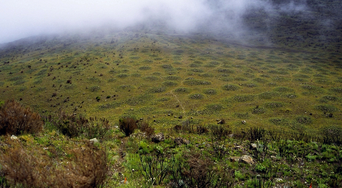
Although Mount Kenya is on the equator the freezing nightly temperatures result in periglacial landforms. There is permafrost a few centimetres (inches) below the surface. Patterned ground is present at 3400 m to the west of Mugi Hill. These mounds grow because the repeated freezing and thawing of the ground draws in more water. There are blockfields present around 4000 m where the ground has cracked to form hexagons. Solifluction occurs when the night temperatures freeze the soil before it thaws again in the morning. This daily expansion and contraction of the soil prevent the establishment of vegetation.
Rivers
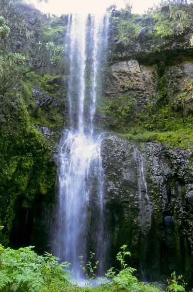
Mount Kenya is the main water catchment area for two large rivers in Kenya; the Tana, the largest river in Kenya, and the Ewaso Nyiro North. The Mount Kenya ecosystem provides water directly for over 2 million people. The rivers on Mount Kenya have been named after the villages on the slopes of the mountain that they flow close to. The Thuchi River is the district boundary between Tharaka Nithi and Embu. Mount Kenya is a major water tower for the Tana river which in 1988 supplied 80% of Kenya's electricity using a series of seven hydroelectric power stations and dams.{{cite journal
The density of streams is very high, especially on the lower slopes which have never been glaciated. The ice cap which used to cover the mountain during the Pliocene eroded large U-shaped valleys which tend to only have one large stream. Where the original shape of the shield volcano is still preserved, there have been millions of years for streams to erode the hillside. This area is therefore characterised by frequent deep fluvial V-shaped valleys. The gradual transition from glaciated to the fluvial valley can be clearly observed.
Rivers that start on Mount Kenya are the tributaries of two large Kenyan rivers: the Tana and the Ewaso Ng'iro rivers. A lot of Mount Kenyan rivers flow into the Sagana which itself is a tributary of the Tana, which joins at the Masinga Reservoir. The rivers in the northern part of the mountain, such as the Burguret, Naru Moru, Nanyuki, Likii, and Sirimon flow into the Ewaso Nyiro. The rivers to the southwest, such as the Keringa and Nairobi flow into the Sagana and then into the Tana. The remaining rivers to the south and east, such as the Kathitâ (Largest River in Meru), Mutonga, Nithi, Thuchi, and Nyamindi, flow directly into the Tana.
Natural history
Main article: Natural history of Mount Kenya
Mount Kenya has several altitudinal ecological zones, from the savanna surrounding the mountain to the nival zone by the glaciers. Each zone has a dominant species of vegetation. Many of the species found higher up the mountain are endemic, either to Mount Kenya or East Africa.
There are also differences within the zones, depending on the side of the mountain and the aspect of the slope. The southeast is much wetter than the north, so species more dependent on moisture can grow. Some species, such as African alpine bamboo, are limited to certain aspects of the mountain because of the amount of moisture.
Zones

The climate of Mount Kenya changes considerably with altitude, forming belts of community types. Around the base of the mountain is fertile farmland. The people living around the mountain have cultivated this cool, relatively moist area for centuries.
Mount Kenya is surrounded by forests. The vegetation in the forests depend on rainfall, and the species present differ greatly between the northern and southern slopes.{{cite book
Above the forest is a belt of African alpine bamboo. This zone is almost continuous but is restricted to small isolated bunches in the north because of low rainfall. The bamboo is natural, and does not require forest disturbance. Tracks are common through the bamboo. Bamboo suppresses other vegetation, so it is uncommon to find trees or other plants here.

Above the bamboo is the timberline forest. The trees here are often smaller than the trees in the forests lower down the mountain. The forest here is more intact because it is less accessible and better protected.
When the trees can no longer grow the vegetation changes into heathland and chaparral, at around 3000 m. Heathland is found in the wetter areas, on the west side of Mount Kenya, and is dominated by giant heathers. Chaparral is found in drier areas and grasses are more common. and bushfires still occur.
As the altitude increases the temperature fluctuations become extreme and the air becomes thinner and drier. This region is known as the Afro-alpine zone. The environment here is isolated, with the only similar area nearby being the Aberdares, which are 80 km away. Many of the species here are endemic, with adaptations to the cold and fluctuating temperatures.{{cite journal
The region where the glaciers have recently retreated from is nival zone. It is the area that plants have not yet been able to colonise.
Flora
The flora found on Mount Kenya varies with altitude, aspect, and exposure. As the altitude increases, the plants have to be more specialised, with adaptations to strong sunlight with ultraviolet, lower mean temperatures, and freezing night temperatures.
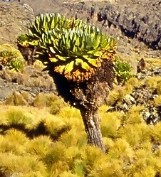
Plants in the Afro-alpine zone have overcome these difficulties in several ways. One adaptation is known as the giant rosette, which is exhibited by giant senecio, giant lobelia, and giant thistle (Carduus), which use bud leaves to protect their buds from freezing. Giant rosette senecios form single-aged stands that drive community structure over decades.{{cite journal
Many plant species in the Afro-alpine zone of Mount Kenya are giant versions of lowland (or temperate) relatives. However, nearer the nival zone the plants decrease in size again.

Fauna

The majority of animals live lower down on the slopes of Mount Kenya. Here there is more vegetation and the climate is less extreme. Various species of monkeys, several antelopes, tree hyrax, porcupines, and some larger animals such as elephants and buffalo all live in the forest. Predators found here include hyenas and leopards, and occasionally lions.
There are fewer mammals found at high altitudes on Mount Kenya.
Other mammal species are only occasional visitors. Remains of elephants, monkeys, and bongo have been found high in the alpine zone, and other sightings are remembered in names such as Simba Tarn (simba means lion in Swahili).
Several bird species live in the Afro-alpine zone, including sunbirds, alpine chats and starlings and the raptors, augur buzzard, lammergeier and Verreaux's eagle, the latter of which specializes in hunting hyraxes. Birds are important in this ecosystem as pollinators.{{cite journal
Climate
Main article: Climate of Mount Kenya
The climate of Mount Kenya has played a critical role in the development of the mountain, influencing the topography and ecology amongst other factors. It has a typical equatorial mountain climate which Hedberg described as winter every night and summer every day.{{cite journal
Seasons

The year is divided into two distinct wet seasons and two distinct dry seasons which mirror the wet and dry seasons in the Kenyan lowlands.{{cite journal Combined, these water sources feed 11 glaciers.
The current climate on Mount Kenya is wet, but drier than it has been in the past. The temperatures span a wide range, which diminishes with altitude. In the lower alpine zone temperature usually do not go below 12 C.{{cite journal
Mount Kenya, like most locations in the tropics, has two wet seasons and two dry seasons as a result of the monsoon. From mid-March to June the heavy rain season, known as the long rains, brings approximately half of the annual rainfall on the mountain.{{cite book
Daily pattern
During the dry season, the mountain almost always follows the same daily weather pattern. Large daily temperature fluctuations occur which led Hedberg to exclaim winter every night and summer every day. There is variation in minimum and maximum temperatures day to day, but the standard deviation of the mean hourly pattern is small.

A typical day is clear and cool in the morning with low humidity. The mountain is in direct sunlight which causes the temperatures to rise quickly with the warmest temperatures occurring between 09:00 and 12:00. This corresponds to a maximum in the pressure, usually around 10:00. Low on the mountain, between 2400 and, clouds begin to form over the western forest zone, due to moist air from Lake Victoria. The anabatic winds caused by warm rising air gradually bring these clouds to the summit region in the afternoon. Around 15:00 there is a minimum in sunlight and a maximum in humidity causing the actual and perceived temperature to drop. At 16:00 there is a minimum of pressure. This daily cover of clouds protects the glaciers on the southwest of the mountain which would otherwise get direct sun every day, enhancing their melt.{{cite book | url-access = registration
Being an equatorial mountain the daylight hours are constant with twelve-hour days. Sunrise is about 06:30 with the sun setting at 18:30 (both EAT = UTC+3). Over the year there is a one-minute difference between the shortest and longest days. At night, the sky is usually clear with katabatic winds blowing down the valleys. Above the lower alpine zone there is usually frost every night.
History
European documentation

The first European to report seeing Mount Kenya was Dr Johann Ludwig Krapf, a German missionary, from Kitui,{{cite book a town 150 km away from the mountain. The sighting was made on 3 December 1849, a year after the first sighting of Mount Kilimanjaro by a European.
Krapf was told by the Embu people that lived around the mountain that they did not ascend high enough on the mountain because of the intense cold and the white matter that rolled down the mountains with a loud noise. This led him to infer that glaciers existed on the mountain. It was Krapf who gave the mountain the name "Kenya", but the derivation of this is not known with certainty.
Krapf also noted that the rivers flowing from Mount Kenya, and other mountains in the area, were continuously flowing. This was very different from the other rivers in the area, which swelled up in the wet season and completely dried up after the rainy season had ended. As the streams flowed even in the driest seasons he concluded that there must be a source of water up on the mountain, in the form of glaciers. He believed the mountain to be the source of the White Nile.{{cite journal
In 1851 Krapf returned to Kitui. He travelled 65 km closer to the mountain, but did not see it again. In 1877 Hildebrandt was in the Kitui area and heard stories about the mountain, but also did not see it. Since there were no confirmations to back up Krapf's claim people began to be suspicious.
In 1883 Joseph Thomson passed close by the west side of the mountain and confirmed Krapf's claim. He diverted his expedition and reached 1737 m up the slopes of the mountain but had to retreat because of trouble with local people. The first European exploration high onto the mountain was achieved in 1887 by Count Sámuel Teleki. He managed to reach 4350 m on the southwestern slopes.{{cite book
In 1892, Teleki and von Höhnel returned to the eastern side but were unable to get through the forest.
In 1893, an expedition managed to ascend Mount Kenya as far as the glaciers. This expedition was traveling from the coast to Lake Baringo in the Rift Valley and was led by Dr. John W Gregory, a British geologist. They managed to ascend the mountain to around 4730 m and spent several hours on the Lewis Glacier with their guide. On his return to Britain, Gregory published papers and a narrative account of his achievements.
George Kolb, a German physician, made expeditions in 1894 and 1896 and was the first to reach the moorlands on the east side of the mountain. More exploration occurred after 1899 when the Uganda Railway was completed as far as the future site of Nairobi.
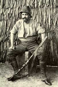
Mackinder's expedition
On 28 July 1899, Sir Halford John Mackinder set out from the site of Nairobi on an expedition to Mount Kenya. The members of the expedition consisted of 6 Europeans, 66 Swahilis, 2 Maasai guides, and 96 Kikuyu. The Europeans were Campbell B. Hausberg, second in command and photographer; Douglas Saunders, botanist; C F Camburn, taxidermist; Cesar Ollier, guide; and Josef Brocherel, guide, and porter.{{cite journal | author-link = Halford John Mackinder | date=May 1900 The expedition made it as far as the mountain but encountered many difficulties on the way. The country they passed through was full of plague and famine. Many Kikuyu porters tried to desert with women from the villages, and others stole from the villages, which made the chiefs very hostile towards the expedition. When they reached the base camp on 18 August, they could not find any food, suffered two of their party killed by the local people, and eventually had to send Saunders to Naivasha to get help from Captain Gorges, the Government Officer there.
Mackinder pushed on up the mountain and established a camp at 3142 m in the Höhnel Valley. He made his first attempt on the summit on 30 August with Ollier and Brocherel up the southeast face, but they had to retreat when they were within 100 m of the summit of Nelion due to nightfall.
On 5 September, Hausberg, Ollier, and Brocherel made a circuit of the main peaks looking for an easier route to the summit. They could not find one. On 11 September Ollier and Brocherel made an ascent of the Darwin Glacier, but were forced to retreat due to a blizzard.
When Saunders returned from Naivasha with the relief party, Mackinder had another attempt at the summit with Ollier and Brocherel. They traversed the Lewis Glacier and climbed the southeast face of Nelion. They spent the night near the gendarme and traversed the snowfield at the head of the Darwin Glacier at dawn before cutting steps up the Diamond Glacier. They reached the summit of Batian at noon on 13 September 1899 and descended by the same route.
During the expedition, Mackinder ordered for 8 of the 90 African porters, who he had bought from a slave owner to carry his supplies, to be shot.
1900–1930

After the first ascent of Mount Kenya, there were fewer expeditions there for a while. The majority of the exploration until after the First World War was by settlers in Kenya, who were not on scientific expeditions. A Church of Scotland mission was set up in Chogoria, and several Scottish missionaries ascended to the peaks, including Rev Dr. J. W. Arthur, G. Dennis and A. R. Barlow. There were other ascents, but none succeeded in summitting Batian or Nelion.
New approach routes were cleared through the forest, which made access to the area of the peak far easier. In 1920, Arthur and Sir Fowell Buxton tried to cut a route in from the south, and other routes came in from Nanyuki in the north, but the most commonly used was the route from the Chogoria mission in the east, built by Ernest Carr. Carr is also credited with building Urumandi and Top Huts.
On 6 January 1929, the first ascent of Nelion was made by Percy Wyn-Harris and Eric Shipton. They climbed the Normal Route, then descended to the Gate of Mists before ascending Batian. On 8 January they reascended, this time with G. A. Sommerfelt, and in December Shipton made another ascent with R. E. G. Russell. They also made the first ascent of Point John. During this year the Mountain Club of East Africa was formed.
At the end of July 1930, Shipton and Bill Tilman made the first traverse of the peaks. They ascended by the West Ridge of Batian, traversed the Gate of Mists to Nelion, and descended the Normal Route. During this trip, Shipton and Tilman made the first ascents of several other peaks, including Point Peter, Point Dutton, Midget Peak, Point Pigott, and either Terere or Sendeyo.{{cite book
1931 to present day
In the early 1930s, there were several visits to the moorlands around Mount Kenya, with fewer as far as the peaks. Raymond Hook and Humphrey Slade ascended to map the mountain, and stocked several of the streams with trout. By 1938 there had been several more ascents of Nelion. In February, Miss C Carroll and Mtu Muthara became the first woman and African respectively to ascend Nelion, in an expedition with Noel Symington, author of The Night Climbers of Cambridge, and on 5 March Miss Una Cameron became the first woman to ascend Batian.
During the Second World War there was another drop in the ascents of the mountain. The most remarkable ascent during this period was by three Italians who were being held in a British POW camp at the base of the mountain in Nanyuki. They escaped from camp to climb the mountain's third peak, Point Lenana, before "escaping" back into camp. Felice Benuzzi, the team leader, retold his story in the book No Picnic on Mount Kenya (1946).{{cite web |url-status=dead |archive-url=https://web.archive.org/web/20040902081030/http://www.nationalgeographic.com/adventure/0404/adventure_books.html |archive-date=2 September 2004 }}
In 1949 the Mountain Club of Kenya split from the Mountain Club of East Africa, and the area above 3400 m was designated a National Park. A road was built from Naro Moru to the moorlands, allowing easier access.
Many new routes were climbed on Batian and Nelion in the next three decades, and in October 1959 the Mountain Club of Kenya produced their first guide to Mount Kenya and Kilimanjaro. In the early 1970s the Mount Kenya National Park Mountain Rescue Team was formed, and by the end of the 1970s, all major routes on the peaks had been climbed.
On 19 July 2003, a South African registered aircraft, carrying 12 passengers and two crew, crashed into Mount Kenya at Point Lenana; nobody survived. This was not the first aircraft lost on the mountain; there is also the wreckage of at least one helicopter that crashed before 1972.{{Cite newspaper The Times
In March 2012 a massive fire raged on Mount Kenya, devouring thousands of hectares of ancient forests and endangered wildlife.
Mountaineering
Main article: Mountaineering on Mount Kenya
Climbing routes
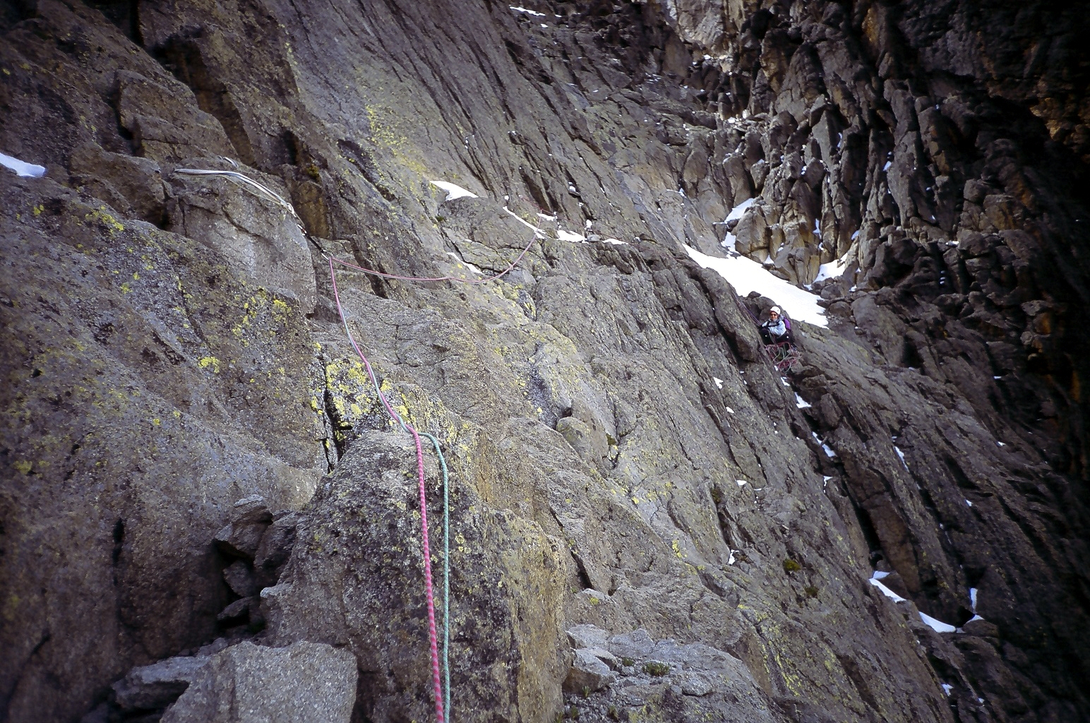
Most of the peaks on Mount Kenya have been summited. The majority of these involve rock climbing as the easiest route, although some only require a scramble or a walk. The highest peak that can be ascended without climbing is Point Lenana, 4985 m.{{cite book
When ascended directly, Batian is usually climbed via the North Face Standard Route, UIAA grade IV+ (or 5.6+ YDS). The first recorded ascent of Batian was on 13 September 1899 by Sir Halford John Mackinder, Cesar Ollier, and Josef Brocherel. The Normal Route is the most climbed route up Nelion, and thence across to Batian. It was first climbed by Eric Shipton and Percy Wyn-Harris on 6 January 1929.{{cite web | archive-url = https://web.archive.org/web/20080214052053/http://www.ewpnet.com/eaimg/Mount_Kenya_climbs.htm | archive-date = 14 February 2008 | access-date = 19 May 2009
Mount Kenya's climbing seasons are a result of its location only 20 km from the equator. During the northern summer, the rock routes on the north side of the peak are in good summer condition, while at the same time, the ice routes on the south side of the peak are in prime shape. The situation is reversed during the southern summer. The two seasons are separated by several months of the rainy season before and after, during which climbing conditions are generally unfavorable.
Mount Kenya is home to several good ice routes, the two most famous being the Diamond Couloir and the Ice Window route. Snow and ice levels on the mountain have been retreating at an accelerated rate in recent years, making these climbs increasingly difficult and dangerous. The Diamond Couloir, a steep ice couloir fed by the fusion of the upper Diamond Glacier, was first climbed by National Park staff Phil Snyder and Thumbi Mathenge in October 1973. A direct finish was pioneered in 1975 by Yvon Chouinard and Michael Covington The couloir was once climbable in summer or winter but now is virtually unclimbable in summer conditions and is seldom deemed in climbable condition even in winter. Last climbing reports describe the route very difficult, especially in the lower section. The route has changed into a modern ice climb with a very difficult 60m first pitch, starting with 8m of overhanging M7 dry tooling, followed by 50m of USA Grade V ice and by 6 pitches of moderate climbing on good ice and finally one pitch of water ice USA Grade IV+ ice at the headwall before getting to the Upper Diamond Glacier.
The satellite peaks around the mountain also provide good climbs. These can be climbed in Alpine style and vary in difficulty from a scramble to climbing at UIAA grade VI. They are useful for acclimatisation before climbing the higher peaks and as ascents in their own right.
Walking routes

There are eight walking routes up to the main peaks. Starting clockwise from the north these are the: Meru, Chogoria, Kamweti, Naro Moru, Burguret, Sirimon, and Timau Routes. Of these Chogoria, Naro Moru, and Sirimon are used most frequently and therefore have staffed gates. The other routes require special permission from the Kenya Wildlife Service to use.{{cite web | archive-url = https://web.archive.org/web/20071217091034/http://www.ewpnet.com/eaimg/Mount_Kenya_general.htm | archive-date = 17 December 2007 | access-date = 19 May 2009
The Chogoria route leads from Chogoria town up to the peaks circuit path. It heads through the forest to the south-east of the mountain to the moorland, with views over areas such as Ithanguni and the Giant's Billiards Table before following the Gorges Valley past the Temple and up to Simba Col below Point Lenana. The Mountain Club of Kenya claims that Ithanguni and the Giant's Billiards Table offer some of the best hillwalking in Kenya.
The Naro Moru route is taken by many of the trekkers who try to reach Point Lenana. It can be ascended in only 3 days and has bunkhouses at each camp. The route starts at Naro Moru town to the west of the mountain and climbs towards Mackinder's Camp before joining the Peak Circuit Path. The terrain is usually good, although one section is called the Vertical Bog.
The Sirimon route approaches Mount Kenya from the northwest. The path splits on the moorlands, with the more frequently used fork following the Mackinder Valley and the quieter route traversing into the Liki North Valley. The paths rejoin at Shipton's Cave just below Shipton's Camp on the Peak Circuit Path.
The Peak Circuit Path is a path around the main peaks, with a distance of about 10 km and height gain and loss of over 2000 m. It can be walked in one day, but more commonly takes two or three. It can also be used to join different ascent and descent routes. The route does not require technical climbing.
Development is currently underway for a new route up the mountain starting from the Ragati conservancy and running up the ridge between the Naro Moru route and the old Kamweti trail.
Image:Mt kenya gorges valley chogoria route.jpg|The Gorges Valley is a major feature on the Chogoria Route. Image:Vertical Bog Mt Kenya.JPG|Vertical bog on Mount Kenya on the Naro Moru Route. File:View into the Mackinder Valley 3900m.JPG|Looking towards the peaks up the Mackinder Valley on the Sirimon Route.
File:Mt kenya austrian hut with nelion.jpg|Austrian Hut is found near the Lewis Glacier on the slopes of Point Lenana. The hut sleeps 30 people, with Top Hut nearby for porters. File:Mt kenya liki north hut.jpg|Liki North Hut is a small bothy in the Liki North Valley. It offers little more than shelter from the weather. File:Mt kenya shiptons camp with sendeyo.jpg|Shipton's Camp is at the top of the Sirimon Route. It has a large communal area and running cold water. File:Mount Kenya 14200ft camp.jpg|Camping is allowed anywhere within the National Park.
Etymology
Main article: List of names on Mount Kenya
The origin of the name Kenya is not clear but perhaps linked to the Kikuyu, Embu, and Kamba words Kirinyaga, Kinyaga and Kiinyaa which mean "God's resting place" in all three languages.
In the 19th Century, the German explorer, Ludwig Krapf, recorded the name as both Kenia and Kegnia, assumed by some to be a corruption of the Kamba version.{{cite journal | author-link = Johann Ludwig Krapf | date = 13 May 1850 Others however claim that this was on the contrary a very precise notation of the correct African pronunciation . In any case, the name was for a long time pronounced by colonial-heritage Europeans as . The European pronunciation has been abandoned in modern times, in favor of the African version.
Names of peaks
The peaks of Mount Kenya have been given names from three different sources. Firstly, several Maasai chieftains have been commemorated, with names such as Batian, Nelion, and Lenana. They commemorate Mbatian, a Maasai Laibon (Medicine Man), Nelieng, his brother, and Lenana and Sendeyo, his sons. Terere is named after another Maasai headman.
The second type of name that was given to peaks is after European climbers and explorers. Some examples of this are Shipton, Sommerfelt, Tilman, Dutton, and Arthur.
The remaining names are after well-known Kenyan personalities, except John and Peter, which were named by the missionary Arthur after two disciples. There is a group of four peaks to the east of the main peaks named after European settlers; Coryndon, Grigg, Delamere, and McMillan.
References
References
- [http://peaklist.org/WWlists/ultras/africa.html "Africa Ultra-Prominences"] Peaklist.org. Retrieved 6 February 2012.
- (2006). "Rough Guide Map Kenya". Rough Guide.
- (8 June 2018). "Where is Mount Kenya Located?".
- TravelMedals. (2020-01-26). "Mount Kenya Summit Challenge!".
- Waita, Edwin. (Feb 25, 2021). "In Kenya, electric fences protect forests from human destruction". Reuters New Service.
- (7 September 2012). "Mt Kenya to get electric fence to stop wildlife straying". BBC.
- (1 December 2014). "Edifice growth and collapse of the Pliocene Mt. Kenya: Evidence of large scale debris avalanches on a high altitude glaciated volcano". Global and Planetary Change.
- "Mount Kenya Climbing guide". Ewpnet.com.
- https://iopscience.iop.org/article/10.1088/2752-5295/ad1fd7
- (2005). "Mammal Species of the World: a taxonomic and geographic reference". The Johns Hopkins University Press.
- "Sunset & sunrise calculator (altitude not taken into account)".
- Mackinder, Halford. (1900). "A Journey to the Summit of Mount Kenya, British East Africa". [[The Geographical Journal]].
- (22 October 2019). "Oxford Geography's Uncomfortable History". [[School of Geography and the Environment, University of Oxford]].
- Benuzzi, Felice. (2005). "No Picnic on Mount Kenya: A Daring Escape, a Perilous Climb". The Lyons Press.
- On Kenyan independence in 1963, Kisoi Munyao raised the Kenyan flag at the top of the mountain. He died in 2007 and was given a heroic funeral attended by the Kenyan president [[Mwai Kibaki]].Kenya Broadcasting Corporation, 11 April 2007: [https://web.archive.org/web/20230221064840/https://www.kbc.co.ke/story.asp?ID=42031 An hero is laid to rest]
- ''Charter aircraft crashes into Kenya's Mount Kenya.'', Airline Industry Information, 21 July 2003
- ''Rescue teams resume efforts to recover bodies of those killed in charter aircraft crash'', Airline Industry Information, 23 July 2003
- Ranter, Harro. "Accident Bell 206L-3 LongRanger III 5Y-TOR, Friday 19 September 2008".
- "Fire devours Kenya's ancient forests". Al Jazeera.
- Alpine Journal Vol. 42
- Iain Allan: ''The Mountain Club of Kenya Guide to Mount Kenya and Kilimanjaro'' (Nairobi; Mountain Club of Kenya, 1998) p107
- "Diamond Couloir Still Climbable".
- (2007). "Mount Kenya Map and Guide". EWP.
- Wangari Maathai. (2006). "Unbowed: a memoir". Alfred A. Knopf.
- {{OED. Kenya
This article was imported from Wikipedia and is available under the Creative Commons Attribution-ShareAlike 4.0 License. Content has been adapted to SurfDoc format. Original contributors can be found on the article history page.
Ask Mako anything about Mount Kenya — get instant answers, deeper analysis, and related topics.
Research with MakoFree with your Surf account
Create a free account to save articles, ask Mako questions, and organize your research.
Sign up freeThis content may have been generated or modified by AI. CloudSurf Software LLC is not responsible for the accuracy, completeness, or reliability of AI-generated content. Always verify important information from primary sources.
Report