From Surf Wiki (app.surf) — the open knowledge base
Mount Kailash
Religious mountain in Tibet Autonomous Region

Religious mountain in Tibet Autonomous Region
| Field | Value |
|---|---|
| fetchwikidata | ALL |
| name | Mount Kailash |
| other_name | Gang Tise |
| Gang Rinpoche | |
| photo | Kailash north.JPG |
| photo_caption | North face of Mount Kailash |
| map | China Tibet Ngari |
| location | Burang County, Tibet Autonomous Region |
| country | China |
| label_position | right |
| range | Gangdise Shan |
| coordinates | |
| native_name | bo |
| language | Tibetan |
| map_size | 300 |
| first_ascent | Unclimbed (prohibited) |
| elevation_m | 6638 |
| elevation_ref | |
| mapframe | yes |
| mapframe-zoom | 10 |
| mapframe-wikidata | yes |
Gang Rinpoche | mapframe-zoom = 10 | mapframe-wikidata = yes
Mount Kailash (also Kailasa, Gang Tise and Gang Rinpoche or Kangrinboqê) is a mountain in Ngari Prefecture, Tibet Autonomous Region of China. It lies in the Gangdise Shan mountain range of the Transhimalaya, in the western part of the Tibetan Plateau. The peak of Mount Kailash is located at an elevation of 6638 m, near the western trijunction between China, India and Nepal.
Mount Kailash is located close to Manasarovar and Rakshastal lakes. The sources of four rivers: Indus, Sutlej, Brahmaputra, and Ghaghara lie in the vicinity of the region. Mount Kailash is sacred in Bon, Buddhism, Hinduism, and Jainism. People from China, India, Nepal, and other countries in the region undertake a pilgrimage to the mountain. The pilgrimage generally involves trekking towards Lake Manasarovar and a circumambulation of Mount Kailash.
While the mountain has been surveyed by climbers in the past, there has been no recorded successful ascent of the mountain. The climbing of the mountain is prohibited by the Chinese government due to its religious significance.
Etymology
The mountain is known as "sa" (कैलास; var. sa कैलाश) in Sanskrit. The name could have been derived from the word "sa" (केलास), which means "crystal".
In his Tibetan-English dictionary, Sarat Chandra Das states that 'kai la ca' () from Sanskrit sa is used to denote the mountain. The mountain is also called as Gang Rinpoche (Tibetan: གངས་རིན་པོ་ཆེ་; ) or Gang Tise locally. Gang Rinpoche means "snow jewel mountain" with Kang (or Gang) being the Tibetan word meaning white mountain (snow peak) and rinpoche is an honorific meaning "precious one". Gang Tise means "mountain of ice or cool".
Geography and topography
Mount Kailash is located in Ngari Prefecture, Tibet Autonomous Region of China. It lies in the Gangdise Shan (also called as Kailash Range) of the Transhimalaya, in the western part of the Tibetan Plateau. The peak of Mount Kailash is at an elevation of 6638 m. The region is located north of the western tripoint of the border between China, India and Nepal.
The major rivers rising from the western Gangdise Mountains are the Yarlung Tsangpo (which becomes the Brahmaputra), the Indus, the Sutlej and the Ghaghara, a tributary of the Ganges. All these river systems originate within a 60 km stretch in the region. Mount Kailash is located on the banks of Manasarovar and Rakshastal lakes. Spread over an area of 320 km2, Manasarovar is the highest freshwater lake in the world.
Geology
The region around Mount Kailash are remnants of large ice sheets that covered the region during the Quaternary period, the last of which retreated about 10,000 years ago. The mountain might be a large metasedimentary roof pendant supported by a base of granite. The Indus headwaters area is typified by wide-scale faulting of metamorphosed late-Cretaceous to mid-Cenozoic sedimentary rocks interspersed with igneous Cenozoic granitic rocks. The Cenozoic rocks represent offshore marine limestones deposited before subduction of the Tethys oceanic crust. These sediments were deposited on the southern margin of the Asia block during subduction of the Tethys oceanic crust before the collision between the Indian and Asian continents. It also consists of sand dunes covering late Eocene volcanic forms interspersed with Cretaceous and Eocene sediments.
The Kailash flysch zone extends about 20 km from the mountain and marks the northern end of the Himalayas and the start of the Trans Himalayas. The Trans Himalayan range was formed by the subduction of sediments from the collision of the Indian and Eurasian plates. The flysch zone consists of alternate areas of peridotites, sandy shales, and dolomites, covered by gravel terraces. The mountain itself consists of thick conglomerate rocks sitting on granite. The visible part of the conglomerates extend from 4700 m to the top with the base located deeper in the mountain.
Climate
The weather is fairly dry during April to June with day time temperatures of 5 to 17 °C and night time temperatures of 0 to 6 °C. The temperature starts to decrease in October and winters have much lower day time temperatures ranging from -4 to 0 °C and further lower in the night reaching up to -20 °C with January being the coldest. Monsoons bring rain from late June to August with cold winds.
Global warming is described as happening three times faster (by about 0.3 C per decade) on the Tibetan Plateau than the global average with lesser snowfall in the winter. According to locals, the land around Mount Kailash has been growing warmer in recent years with winters not as cold as it used to be. The retreating glaciers and thawing of the permafrost in the Tibet region might lead to uncertain effects on water resources of the region. These effects along with population explosion and tourism has put severe stress on the fragile ecosystem around Mount Kailash.
The intergovernmental organisation International Centre for Integrated Mountain Development (ICIMOD) is involved in a trans boundary project called the Kailash Sacred Landscape Conservation and Development Initiative in the region around Mount Kailash. The organization is involved in ongoing efforts to generate climate data, and to devise sustainable ways of life for the people of the region.
Mountaineering

In 1926, Hugh Ruttledge, the deputy commissioner of Almora, visited the area to meet the Garpön (local Tibetan leader) of Ngari. As the Garpön was away, he circumambulated Mount Kailash while studying it. As per Ruttledge, the mountain was about 6000 m high and utterly unclimbable. He thought about an ascent along the northeast ridge and had been exploring the area with Colonel R. C. Wilson, who was on the other side of the mountain with a Sherpa named Tseten. As per Wilson, Tseten told him that the southeast ridge represented a feasible route to the summit. Wilson explained that although they attempted to climb the mountain, they ran into heavy snowfall, making the ascent impossible.
Herbert Tichy visited the area in 1936, attempting to climb the mountain. When he asked the local people whether Kailash was climbable, a Garpön replied: "Only a man entirely free of sin could climb Kailash. And he wouldn't have to actually scale the sheer walls of ice to do it — he'd just turn himself into a bird and fly to the summit". Italian mountaineer Reinhold Messner was given the opportunity by the Chinese government to climb the mountain in the mid-1980s, but he reportedly declined, saying "If we conquer this mountain, then we conquer something in people's souls. I would suggest they go and climb something a little harder." In 2001, permission was denied to a Spanish team, who requested to climb the peak. Chinese authorities stated that any climbing activities on Mount Kailash were strictly prohibited. To date, there have been no known successful ascents of the mountain.
Religious significance
Mount Kailash is considered sacred in Buddhism, Bon, Hinduism, and Jainism.
Buddhism and Bon

As per Buddhist texts, Mount Kailash (Kailasa) is known as the mythological Mount Meru. Kailash is central to its cosmology, and a major pilgrimage site for some Buddhist traditions. In Buddhism, Kailash represents the father of the world and Lake Manasarovar symbolizes the mother. Numerous sites in the region are associated with Padmasambhava, who is credited with establishing Tantric Buddhism in Tibet in the 8th century CE. Vajrayana Buddhists believe that saint Milarepa () had a challenge with Naro Böncham, a follower of Bön religion of Tibet. The two engaged in a battle of wits with neither able to gain a decisive advantage. Finally, it was agreed that whoever could reach the summit of Kailash first would be the victor. While Naro sat on his magic drum to climb up the slope, Milarepa reached the summit riding on the rays of the Sun, thus winning the contest. He also gave the nearby mountain, since known as Bönri bequeathing it to Bön.
For the Bon people, the mountain is the abode of sky goddess Sipaimen and the mountain was the centre of the ancient Bon empire of Zhang Zhung. As per Tibetan beliefs, the mountain was the centre of the universe Mandala and the source of the mythical Lion, Horse, Peacock, and Elephant Rivers which flowed in the four cardinal directions.
Hinduism
Main article: Kailasha
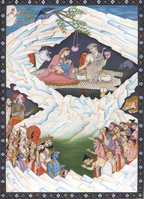
In Hindu art and literature, the mountain is described as the abode of Shiva, who is depicted as residing there along with his consort Parvati and their children, Ganesha and Kartikeya. In early Hindu depictions, Kailash was described as one of the mountains in the Himalayas. In Hindu mythology, Mount Meru is considered as a stairway to heaven, where the devas reside and the Vishnu Purana states that it lies in the center of the world surrounded by six mountain ranges similar to a lotus, one of which is the Himalayas. In the later Hindu theology, Kailash came to be identified with Meru. Shiva is described as sitting in a lotus position, engaged in meditation within the confines of the mountain. Kailash and Manasarovar are mentioned in the Hindu epics Ramayana and Mahabharata. According to the Hindu scriptures and sculptural depictions, the demon-king Ravana shook the mountain after he was refused entry to Kailash. This enraged Shiva, who pressed his toe upon the mountain, trapping Ravana in between. Ravana sang hymns in praise of Shiva for a thousand years before he was released. This representation of Shiva is also referred to as Ravananugraha (meaning "form showing favour to Ravana").
Jainism
According to Jain scriptures, Rishabhadeva, the first Tirthankar of Jainism attained moksha (liberation) on Mount Kailash. It is believed by Jains that after Rishabhadeva attained moksha, his son emperor Bharata Chakravartin had constructed three stupas and twenty four shrines of the 24 tirthankaras in the region with their idols studded with precious stones and named it Sinhnishdha. He also performed a fortnight of worship termed Mahamaga and attained moksha from Kailash. Large pits were dug around the mountain later and the River Ganges was made to flow through it. The 24th and the last Tirthankara, Mahavira, was taken to the summit of Meru by Indra shortly after his birth, after putting his mother into deep slumber. There he was anointed with precious unctions.
Pilgrimage
Due to its perceived sacredness to various religions, people undertake a pilgrimage called yatra to the mountain. While it is not known when the first pilgrimage started, it is one of the oldest pilgrimage routes, which has been in existence for many years.

Pilgrimage to the mountain increased in the 1930s but was affected later due to both China and the British Empire claiming the region. Religious pilgrimages to Mount Kailas and Manasarovar were permitted by China after its occupation of Tibet in 1950-51. While pilgrimage from India was guaranteed by the 1954 Sino-Indian Agreement, access was restricted after the subsequent 1959 Tibetan uprising and the borders were closed after the Sino-Indian War in 1962. After nearly two decades, pilgrimage from India was allowed in 1981 after an agreement between the governments of India and China. The pilgrimage was suspended for three years since 2020 due to the COVID-19 pandemic. The route was re-opened in 2023 with new regulations.
Since the reopening of the pilgrimage route from India in 1981, the numbers of pilgrims going on the annual yatra has grown considerably. Before the closure in 2020, several thousand pilgrims from India were going to this pilgrimage every year. Since 2015, aspiring pilgrims from India were required to apply in advance to the Ministry of External Affairs and specific number of passes were issued to pilgrims by computerized random selection with preference given to first timers. In India, the pilgrimage is organized by the Government of India and is permitted between June and September. Pilgrims from India travel through two routes opened for the purpose with border crossings at Lipu Lekh pass in Uttarakhand and the Nathu La pass in Sikkim. Since 2020, a motorable road is available till the Lipu Lekh pass through the Indian side of the Mahakali valley, before crossing over to China. The Nathu La route was opened in 2015 and involves traveling to Gangtok before crossing the Nathu La pass into China.
Since 2015, the pilgrimage from Nepal is commonly undertaken via the Humla district in northwestern Nepal, with a newer and more efficient route now available. The helicopter route from Nepalgunj to Simikot, and then to Hilsa near the Nepal-Tibet border, has become the shortest and most convenient option. The April 2015 Nepal Earthquake resulted in the closure of the border crossing at Tatopani-Zangmu. Pilgrims also pray to Mount Kailash from within Nepal where it is visible from the Lapcha La pass above the Limi valley on a clear day. Another route exists through the crossing at Rasuwa-Gyirong. Pilgrims could reach Lhasa by air before the journey to Lake Manasarovar or Darchen.

The pilgrimage involves trekking towards Lake Manasarovar and a circumambulation of Mount Kailash. The path around Mount Kailash is 53 km long. The circumambulation is made in a clockwise direction by Hindus, Buddhists, and Jains, while Bönpos circumambulate the mountain in a counterclockwise direction. The circumambulation usually begins and ends at Darchen, a small outpost located at an elevation of 4670 m with the highest point at the Drölma pass situated at 5650 m. Trekking around the mountain can be done on foot with support from a pony or domestic yak. The circumambulation takes three days on average with the first day trek from Darchen to Dirapuk gompa for about 14 km, followed by a journey from Dirpauk to Zutulphuk via the Drölma pass for 19 km on the second day and the final trek back to Darchen on the last day. The most extreme method of doing the circumambulation (called Kora) in Tibetan Buddhism is performed by doing full body-length prostrations over the entire stretch around the mountain. The pilgrim bends down, kneels, prostrates full-length, makes a mark with her fingers, rises to her knees, prays, and then crawls forward on hands and knees to the mark made by her fingers before repeating the process. With this method, the pilgrimage takes three weeks on average to complete.
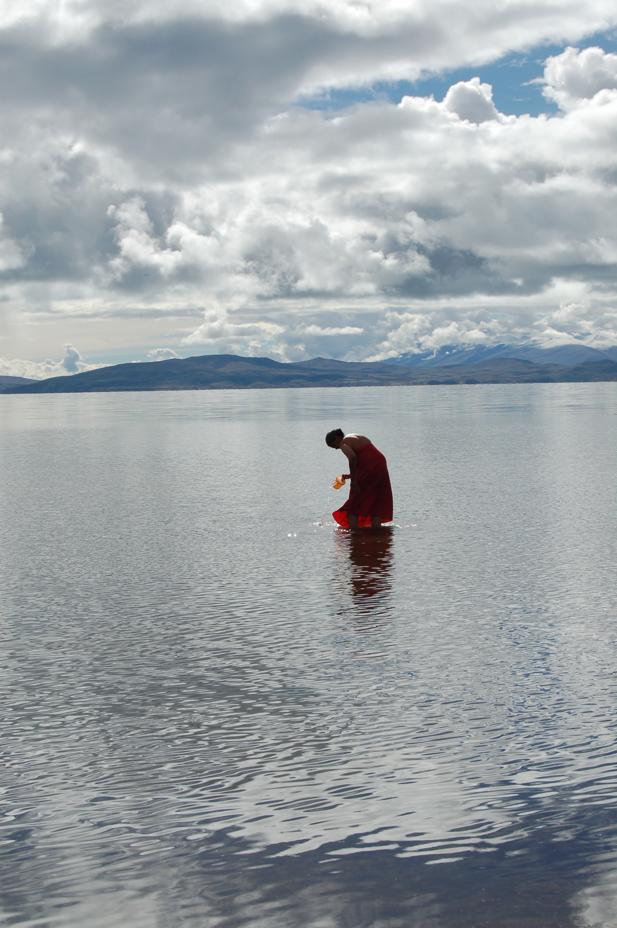
Pilgrims believe that doing a circumambulation of Mount Kailash is a spiritually beneficial practice that can bring various positive effects, such as the cleansing of one's sins. Each circumambulation is considered to have fulfilled a life-death cycle. There are many stupas, flag poles, Buddhist monasteries and praying stations along the route. Many of the cultural artifacts along the route were destroyed during the Cultural Revolution of China from 1966 to 1976. Hindus take a ritual bath in the Manasarovar before doing circumambulation. Hindu text Skanda Purana states that "There are no mountains like the Himalaya, for in them are Kailas and Manasarovar. As the dew is dried up by the morning Sun, so are the sins of mankind dried up by the sight of the Himalaya."
Tibetan Buddhist pilgrims often chant Om mani padme hum (jewel in the lotus) and sing nyelu songs while crossing the Dolma La pass which are believe to proclaim a fraternity amongst all pilgrims who cross paths on a Kailash pilgrimage. As the mountain is located in a remote area of the Himalayas, very few facilities exist to aid during the pilgrimage. For varied reasons for the different faiths that revere the mountain, setting foot on the slopes of the mountain or attempting to climb it is forbidden by law.
References
Bibliography
References
- "Mount Kailas".
- (1997). "The Snow Mountains of China: Kangrin Boqe Topographic Map".
- "Open Topo Map".
- "Sanskrit Dictionary". [[Monier-Williams]].
- "Entry for कैलासः". Apte Sanskrit-English Dictionary.
- Williams, Monier. "Monier-Williams Sanskrit-English Dictionary".
- Shakspo, Nawang Tsering. (1999). "The Role of Incarnate Lamas in Buddhist Tradition: A Brief Survey of Bakula Rinpoche's Previous Incarnations". The Tibet Journal.
- "Imphal's Kangla To Ladakh's Kangla - Postulating A Kang Culture Belt". e-pao.
- "Mount Kailas".
- Freeman Attwood. (2003). "Gangdise Mountains". [[Alpine Journal]].
- "Mount Kaliash, China". Peakbagger.com.
- Claude Arpi. (23 February 2024). "China playing new border games close to Mt Kailash". [[Deccan Chronicle]].
- "Lake Mapam".
- Pete Winn. "Geology and Geography of the Mt. Kailash area and Indus River headwaters in southwestern Tibet".
- "Geology and Geography of the Mt. Kailash area and Indus River headwaters in southwestern Tibet". Ministry of Geology and Mineral Resources, China.
- Francois Debon. (1986). "The Four Plutonic Belts of the Transhimalaya-Himalaya: a Chemical, Mineralogical, Isotopic, and Chronological Synthesis along a Tibet-Nepal Section". Journal of Petrology.
- Augusto Gansser-Biaggi. (1964). "Geology Of The Himalayas". [[Wiley (publisher).
- "Tibet Weather". Tibet tour.
- (12 May 2006). "Kailash Yatra". [[Government of India]].
- Qiu, Jane. (1 July 2008). "China: The third pole". Nature.
- (15 September 2019). "The world has a third pole – and it's melting quickly". [[The Guardian]].
- (9 January 2019). "Ignoring climate change in the Himalayas". The Third Pole.
- Tanguang Gao. (23 April 2021). "Accelerating permafrost collapse on the eastern Tibetan Plateau". Environmental Research Letters.
- (22 June 2009). "Kailash Sacred Landscape Conservation Initiative: Feasibility Assessment Report". [[ICIMOD]].
- (16 December 2019). "About KSLCDI". [[ICIMOD]].
- (16 December 2019). "KSLCDI Components". [[ICIMOD]].
- (27 May 2024). "ICIMOD collaborates with NASA to monitor air quality in the Hindu Kush Himalayas". [[Deccan Herald]].
- (16 May 2017). "Khar's experimentation with Himalayan nettle brings recognition". Down to Earth.
- Hugh Ruttledge. (1928). "Notes on a Visit to Western Tibet in 1926". [[The Royal Geographical Society]].
- R.C.Wilson. (1928). "Kailas Mountains". [[Alpine Journal]].
- Brit Jones. (3 November 2023). "Mountain significantly smaller than Everest has never been climbed by a human". [[Unilad]].
- "Kailash: the mountain that calls". [[Suunto]].
- (23 January 2021). "Are there any mountains left unclimbed?". [[The Spectator]].
- (7 June 2001). "China to Ban Expeditions on Mount Kailash". tew.org.
- (2013). "Passage to Kailash". [[World Literature Today]].
- "Kailash Manasarovar Yatra". [[Ministry of External Affairs (India).
- Karen Swenson. (16 March 2003). "A Sacred Circuit in Tibet". [[The New York Times]].
- "Padmasambhava". [[Britannica]].
- "Rishabhanatha".
- "Jainism Literature Center - Rituals".
- "Kailash Mansarovar Yatra". [[Government of Uttarakhand]].
- (7 April 2022). "Kailash-Mansarovar yatra unlikely to resume this year, say officials". [[The Hindu]].
- (8 May 2023). "Pilgrims to Kailash discouraged by new Chinese rules". [[Kathmandu Post]].
- (19 May 2023). "Kailash Masarovar Yatra hits hurdles ahead of opening next month". [[The Indian Express]].
- "Kailash Manasarovar Yatra likely to see record numbers". [[Kathmandu Post]].
- (16 May 2019). "First-time pilgrims get preference for Mansarovar Yatra". [[The Hindu]].
- "Mansarovar Yatra: First-time pilgrims get preference in computerized draw of lots". [[The Economic Times]].
- "Kailash Manasarovar Yatra". [[Government of India]].
- (11 May 2020). "New road to Kailash Mansarovar via Lipulekh Pass and why Nepal is objecting to it". [[The Print]].
- (15 May 2015). "Alternate Route for Kailash-Mansarovar Yatra Will Become Operational Next Month: PM Modi". [[NDTV]].
- Rudraksha, Nepa. "Kailash Mansarovar Yatra: Ultimate Guide to Spiritual Journey, Routes & Preparation".
- (13 March 2021). "Limi-Lapcha could be an alternative route to Kailash Manasarovar". [[The Himalayan Times]].
- "A Personal Account of Border Crossing Reveals the Deep Ties Between Nepal, China". [[The Wire (India).
- Pandey, Abhimanyu. (20 April 2023). "Ancient bonds: Joining the Kailash-Mansarovar yatra". [[The Hindu]].
This article was imported from Wikipedia and is available under the Creative Commons Attribution-ShareAlike 4.0 License. Content has been adapted to SurfDoc format. Original contributors can be found on the article history page.
Ask Mako anything about Mount Kailash — get instant answers, deeper analysis, and related topics.
Research with MakoFree with your Surf account
Create a free account to save articles, ask Mako questions, and organize your research.
Sign up freeThis content may have been generated or modified by AI. CloudSurf Software LLC is not responsible for the accuracy, completeness, or reliability of AI-generated content. Always verify important information from primary sources.
Report