From Surf Wiki (app.surf) — the open knowledge base
Morrinsville
New Zealand town
New Zealand town
| Field | Value |
|---|---|
| name | Morrinsville |
| image_skyline | Big Cow at Morrinsville.jpg |
| image_caption | Big Cow |
| mapframe | yes |
| mapframe-zoom | 9 |
| subdivision_type | Country |
| subdivision_name | New Zealand |
| subdivision_type1 | Region |
| subdivision_name1 | Waikato |
| subdivision_type2 | Territorial authority |
| subdivision_name2 | Matamata-Piako District |
| subdivision_type3 | Ward |
| subdivision_name3 | Morrinsville General |
| seat_type | Electorates |
| seat | |
| leader_title | Territorial Authority |
| leader_name | Matamata-Piako District Council |
| leader_title1 | Regional council |
| leader_name1 | Waikato Regional Council |
| leader_title2 | Mayor of Matamata-Piako |
| leader_name2 | |
| leader_title3 | Waikato MP |
| leader_name3 | |
| leader_title4 | Hauraki-Waikato MP |
| leader_name4 | |
| area_footnotes | |
| area_total_km2 | 10.28 |
| population_total | |
| population_as_of | |
| population_footnotes | |
| population_density_km2 | auto |
| postal_code_type | Postcode |
| timezone | NZST |
| utc_offset | +12 |
| timezone_DST | NZDT |
| utc_offset_DST | +13 |
| postal_code | 3300 |
| area_code | 07 |
| coordinates | |
| settlement_type | Town |
| mapframe-zoom = 9
Morrinsville () is a provincial town in the Waikato region of New Zealand's North Island. Morrinsville is a service town for the local dairy industry; the area surrounding the town has the highest concentration of dairy cattle in New Zealand.
History and Culture
Pre-European settlement
Prior to European settlement of New Zealand, the hills around present-day Morrinsville were occupied by the Ngati Werewere Māori people of the Ngati Haua Iwi, and the site of the present-day town was on or near to an old Māori route between the upper Waihou-Piako basin and the Ngāruawāhia area.
Following the arrival of Europeans, some early European traders are believed to have traversed this route prior to 1834 when the Rev. J. Morgan travelled up the Piako River to near the future town site and crossed west to Horotiu, near Ngāruawāhia. First recorded contact with European settlers in the area occurred around 1850, with John Johnson trading with the Māori from 1852.
Post-European settlement
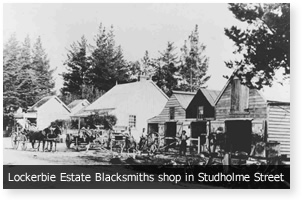
The 1860s saw an influx of European settlers to the area between Te Aroha and Matamata, and on 13 December 1873 a settler from Auckland, Thomas Morrin, purchased the Kuranui No.1 Block from the local Māori and founded the Lockerbie Estate, which Morrin named after the Scottish town from which his father had emigrated. In May 1874, Morrin purchased two further blocks, Motumaoho No.1 and No.2, and his estate then totaled over 30,000 acre. The fledgling village was to be the service centre for Morrin's Lockerbie Estate and he built a blacksmith's shop, manager's house, the Jolly Cripple Hotel and general store and donated land for a school. Morrin hired Irish navvies from the gold fields to dig a network of ditches to drain the land, enabling it to be used for agriculture. In 1882 Morrin surveyed the land for the site of the town proper, and deposited plans for ten streets: Anderson, Hamilton, Studholme, Moorhouse, Lorne, Canada, Cureton, Somerville, Thames and Thorpe (the first and last three streets being named after family members).
The Thames Valley and Rotorua Railway Company began construction of a railway line from Morrinsville to Rotorua in 1879, and on 1 October 1884, the line from Hamilton to Morrinsville was opened. With construction progressing towards Paeroa and the line to Te Aroha opening on 1 March 1886, the town's population was listed as 633 people. There were some proposals for lines to Matamata, Tīrau, and Rotorua, which would have turned Morrinsville into an area where several lines meet, instead a railway line was built to Lichfield. In 1880 Morrinsville was a hamlet with her own school, post office, and hotel. With further expansion of the railway towards Thames and Tauranga, alongside extensive drainage of swamp land to the south and west of the town making available large areas for dairy farming. Morrinsville was declared a town district in 1908 and in 1921 was constituted as a borough.
In 1895 the first church in Morrinsville, an Anglican church, was constructed. In 1907 a police station was constructed. The resident constable also serviced Wardville, Gordon, and Waharoa.
In 1957 Morrinsville annexed land from Piako County. The expansion included land at the south-east up to the Piako River and the Waitakaruru Stream, alongside land near the Tahuna-Waharoa highway, and land around Avenue Road.
In the early 1900s a Māori canoe (waka) was discovered on a property in Tahuna. The 45 foot waka, named Maungateroto, had been laying on the property under a tree for 60 years. The waka was placed outside the Morrinsville War Memorial Hall after being gifted to Morrinsville by Ngati-Paoa in 1968.
Demographics
In 1881 Morrinsville had a population of 115, 30 years later it was 300. When Morrinsville was constituted as a town district in 1911 it had a population of 565. In 1971 Morrinsville's population was 4,454.
Morrinsville covers 10.28 km2 and had an estimated population of as of with a population density of people per km2.
Morrinsville had a population of 9,003 in the 2023 New Zealand census, an increase of 1,110 people (14.1%) since the 2018 census, and an increase of 1,956 people (27.8%) since the 2013 census. There were 4,293 males, 4,695 females and 18 people of other genders in 3,390 dwellings. 2.2% of people identified as LGBTIQ+. The median age was 38.5 years (compared with 38.1 years nationally). There were 1,860 people (20.7%) aged under 15 years, 1,617 (18.0%) aged 15 to 29, 3,627 (40.3%) aged 30 to 64, and 1,896 (21.1%) aged 65 or older.
People could identify as more than one ethnicity. The results were 83.1% European (Pākehā); 19.5% Māori; 2.3% Pasifika; 7.6% Asian; 0.9% Middle Eastern, Latin American and African New Zealanders (MELAA); and 2.0% other, which includes people giving their ethnicity as "New Zealander". English was spoken by 96.0%, Māori language by 4.2%, Samoan by 0.2%, and other languages by 8.0%. No language could be spoken by 2.7% (e.g. too young to talk). New Zealand Sign Language was known by 0.5%. The percentage of people born overseas was 14.5, compared with 28.8% nationally.
Religious affiliations were 30.2% Christian, 0.8% Hindu, 0.4% Islam, 1.0% Māori religious beliefs, 1.5% Buddhist, 0.4% New Age, and 2.1% other religions. People who answered that they had no religion were 56.1%, and 7.6% of people did not answer the census question.
Of those at least 15 years old, 1,158 (16.2%) people had a bachelor's or higher degree, 3,978 (55.7%) had a post-high school certificate or diploma, and 2,010 (28.1%) people exclusively held high school qualifications. The median income was $41,200, compared with $41,500 nationally. 645 people (9.0%) earned over $100,000 compared to 12.1% nationally. The employment status of those at least 15 was that 3,648 (51.1%) people were employed full-time, 870 (12.2%) were part-time, and 171 (2.4%) were unemployed.
| Name | Area | |||||||
|---|---|---|---|---|---|---|---|---|
| (km2) | Population | Density | ||||||
| (per km2) | Dwellings | Median age | Median | |||||
| income | New Zealand | 38.1 years | $41,500 | |||||
| Morrinsville North | 1.85 | 1,593 | 861 | 597 | 37.9 years | $44,200 | ||
| Morrinsville East | 3.24 | 4,143 | 1,280 | 1,581 | 41.8 years | $40,900 | ||
| Morrinsville West | 5.19 | 3,267 | 629 | 1,212 | 35.3 years | $40,300 |
Apart from Morrinsville, the largest number of commuters go to Waihou from Morrinsville East and Tahuroa from West. In 2018 13.8% of the population of Morrinsville East and 25.1% of West were Māori.
Education
Morrinsville College is the town's state secondary school, with a roll of . It opened in 1923 on a trial basis as Matamata District High School and moved to a new site in 1939. It became Morrinsville College in 1950.
Morrinsville Intermediate is the state intermediate school, with a roll of . It opened in 1970.
The town has two state primary schools for Year 1 to 6 students: Morrinsville School, with a roll of ; and David Street School, with a roll of ; Morrinsville School opened in 1877 at Studholme St, and moved in stages to Lincoln Street between 1920 and 1935 as the high school expanded on the original site. David Street School opened in 1955.
A third primary school, Motumaoho School, is located south-west of the town on State Highway 26; it has a roll of .
St Joseph's Catholic School is a state integrated Catholic primary school, with a roll of . It opened in 1930.
All these schools are co-educational. Rolls are as of
Economy
.jpg)
Morrinsville's economic growth is dependent on the surrounding countryside: the Piako country is one of the wealthiest farming areas in the world with the country being good for dairy cattle specifically.
Morrinsville was impacted by the Long Depression but weathered it better than other settlements due to its location on the railway line.
Morrinsville houses several factories involved in agricultural products such as a butter factory, which claims to be the first butter factory in the world to be fully automated,, and a fertiliser factory.
Transportation
Railway
Historically, Morrinsville was the railway junction of the Auckland–Thames and Auckland–Rotorua lines, which subsequently became the Thames Branch and the East Coast Main Trunk Railway (Tauranga) lines. Morrinsville Railway Station was opened on 1 October 1884, to the east off Studholme Street, at the junction of the two lines. A footbridge over the track was opened in 1913, connecting the station with the town from the end of Canada Street. The station was described as consisting of "two asphalt passenger platforms, and the station buildings contain a ladies' waiting room, a large general waiting room, a post office lobby with post and telegraph offices, a ticket office, and offices for the Inspector of Permanent Way. There are also large goods and engine sheds, and cattle loading yards. Five workmen's cottages adjoin the station, and the Bank of New Zealand Estates Company has a large building connected with the siding for seed-cleaning and storage purposes." The station was moved about 1/4 mi towards Hamilton in 1923. The original station building was demolished in 1984 and a smaller building was erected approximately 300 metres to the west off Marshall Street, which is still used by KiwiRail for freight services.

Passenger services are no longer provided to or from Morrinsville Railway Station. The Thames Branch closed on 28 June 1991 and the track subsequently lifted, although in 2004 a short shunt line – the Waitoa Industrial Line – reopened to facilitate freight trains for the Waitoa Dairy Factory. The East Coast Main Trunk Railway provided passenger services between Auckland and Rotorua – the Geyserland Express – and Auckland and Tauranga - the Kaimai Express; however, in 2001 it was announced that these services were too uneconomic to continue, and the last trains ran on 7 October 2001.
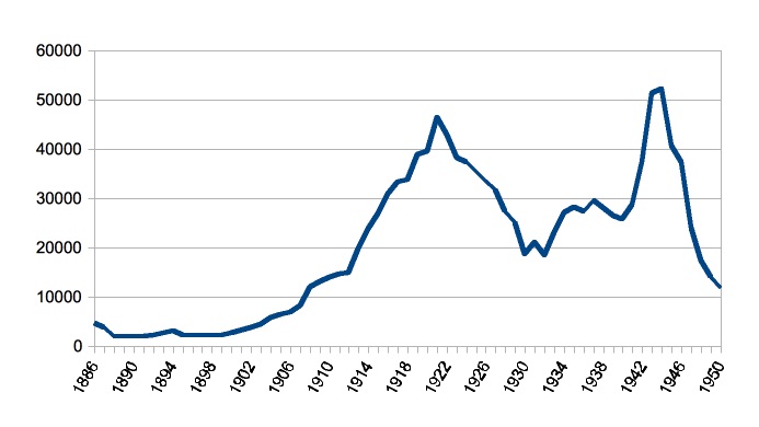
Passenger traffic reached a peak in 1944, as shown in this table and the graph -
| 1950 | 11,797 | 55 | https://paperspast.natlib.govt.nz/parliamentary/appendix-to-the-journals-of-the-house-of-representatives/1950/I/2366 | STATEMENT No. 18 Statement of Traffic and Revenue for each Station for the Year ended 31 March 1950 |
|---|
Road network
Roads in Morrinsville were not metalled until the late 19th century. Roads in the town were dusty and uneven in summer and in winter they were too muddy for horses to progress at a canter. The ride from Annandale to the church in Morrinsville, which is two and a half miles, took an hour.
Transport out of Morrinsville was initially difficult with the only proper road leading to Mangateparu; however, it was quite treacherous and prone to flooding.

Walkways

Notable places
- The Nottingham Castle Hotel was originally built in 1875 as the Jolly Cripple and established as the Nottingham Castle Hotel in 1880. It burnt down in 1913 and was replaced in 1914. It is one of the oldest buildings in Morrinsville and serves a centre for the town.
Reserves
In 1970 a 60 acre farm that bordered the Kuranui Reserve was purchased by the Piako County Council. This was gazetted as a reserve and named Roy Scott Recreation Reserve, in honour of the county chairman. In 1972 a further 27 acre was added onto the reserve.
Sports clubs
- Kereone Rugby & Sports Club, established in 1919.
Climate
|access-date = 25 Nov 2024}}
Notable people
- Stephen Allen (1882–1964), mayor of Morrinsville
- Jacinda Ardern (born 1980), former Prime Minister of New Zealand and former leader of the Labour Party
- Constable Edward Best (1899–1941), born in nearby Annandale
- Maria Dallas (born 1946), pop and country singer
- Ross Ferguson (born 1943), botanist specialising in kiwifruit horticulture
- John Money (1921–2006), psychologist and author known for his controversial research in gender identity
- Hemi Taylor (born 1963), former Wales rugby union player
References
References
- "Mōrena".
- "Land Title; 1876; 7042 - Morrinsville Museum on NZMuseums".
- "Morrinsville".
- "Stats NZ Geographic Data Service".
- {{NZ census 2018. Morrinsville East (173900) and Morrinsville West (174000)
- "Totals by topic for dwellings, (RC, TALB, UR, SA3, SA2, Ward, Health), 2013, 2018, and 2023 Censuses". Stats NZ – Tatauranga Aotearoa – Aotearoa Data Explorer.
- "Totals by topic for individuals, (RC, TALB, UR, SA3, SA2, Ward, Health), 2013, 2018, and 2023 Censuses". Stats NZ – Tatauranga Aotearoa – Aotearoa Data Explorer.
- "Totals by topic for individuals, (RC, TALB, UR, SA3, SA2, Ward, Health), 2013, 2018, and 2023 Censuses". Stats NZ - Tatauranga Aotearoa - Aotearoa Data Explorer.
- "Totals by topic for individuals, (RC, TALB, UR, SA3, SA2, Ward, Health), 2013, 2018, and 2023 Censuses". Stats NZ - Tatauranga Aotearoa - Aotearoa Data Explorer.
- "Totals by topic for individuals, (RC, TALB, UR, SA3, SA2, Ward, Health), 2013, 2018, and 2023 Censuses". Stats NZ - Tatauranga Aotearoa - Aotearoa Data Explorer.
- "SNZ Commuter View".
- "Morrinsville College Official School Website".
- "Morrinsville College Ministry of Education School Profile". [[Ministry of Education (New Zealand).
- "Morrinsville College Education Review Office Report". [[Education Review Office]].
- "School History". Morrinsville College.
- "Morrinsville Intermediate Official School Website".
- "Morrinsville Intermediate Ministry of Education School Profile". [[Ministry of Education (New Zealand).
- "Morrinsville Intermediate Education Review Office Report". [[Education Review Office]].
- "Timeline". Morrinsville Museum.
- "Morrinsville School Ministry of Education School Profile". [[Ministry of Education (New Zealand).
- "Morrinsville School Education Review Office Report". [[Education Review Office]].
- "David Street School Official School Website".
- "David Street School Ministry of Education School Profile". [[Ministry of Education (New Zealand).
- "David Street School Education Review Office Report". [[Education Review Office]].
- "Motumaoho School Ministry of Education School Profile". [[Ministry of Education (New Zealand).
- "Motumaoho School Education Review Office Report". [[Education Review Office]].
- "St Joseph's Catholic School Ministry of Education School Profile". [[Ministry of Education (New Zealand).
- "St Joseph's Catholic School Education Review Office Report". [[Education Review Office]].
- "Our Charism". St Joseph's Catholic School.
- (1976). "Land of the Three Rivers: A Centennial History of Piako County". Wilson & Horton.
- (11 October 2012). "Butter plant celebrates centenary". Stuff.
- (27 Sep 1923). "Local And General. Waikato Independent".
- "Morrinsville River Walk".
- "Holmwood Park Walk".
- (July 2008). "Matamata-Piako District Council Track Strategy".
- "Lockerbie Park Walkway".
- "Parkwood Walking Track".
- (11 June 2015). "Nottingham Castle Hotel".
- "Kereone Club History". Kereone Rugby and Sports Club.
- McClure, Tess. (19 January 2023). "Jacinda Ardern resigns as prime minister of New Zealand". The Guardian.
- Bieleski, Roderick L.. (January 2009). "Horticultural Reviews Volume 35". Wiley-Blackwell.
- "Obituary: John Money". [[The New Zealand Herald]].
- (1966). "An Encyclopaedia of New Zealand".
- (10 March 2014). "Morrinsville History". Matamata-Piako District Council.
- "History of Morrinsville". The Official Website of Morrinsville.
- (1902). "Morrinsville, The Cyclopedia Of New Zealand [Auckland Provincial District]". The New Zealand Electronic Text Collection, Victoria University of Wellington Library.
- (3 June 2014). "Train campaign may not gain traction". The Waikato Times.
This article was imported from Wikipedia and is available under the Creative Commons Attribution-ShareAlike 4.0 License. Content has been adapted to SurfDoc format. Original contributors can be found on the article history page.
Ask Mako anything about Morrinsville — get instant answers, deeper analysis, and related topics.
Research with MakoFree with your Surf account
Create a free account to save articles, ask Mako questions, and organize your research.
Sign up freeThis content may have been generated or modified by AI. CloudSurf Software LLC is not responsible for the accuracy, completeness, or reliability of AI-generated content. Always verify important information from primary sources.
Report