From Surf Wiki (app.surf) — the open knowledge base
Mont-Saint-Michel
Tidal island in Normandy, France
Tidal island in Normandy, France
| Field | Value |
|---|---|
| name | Mont-Saint-Michel |
| commune status | Commune |
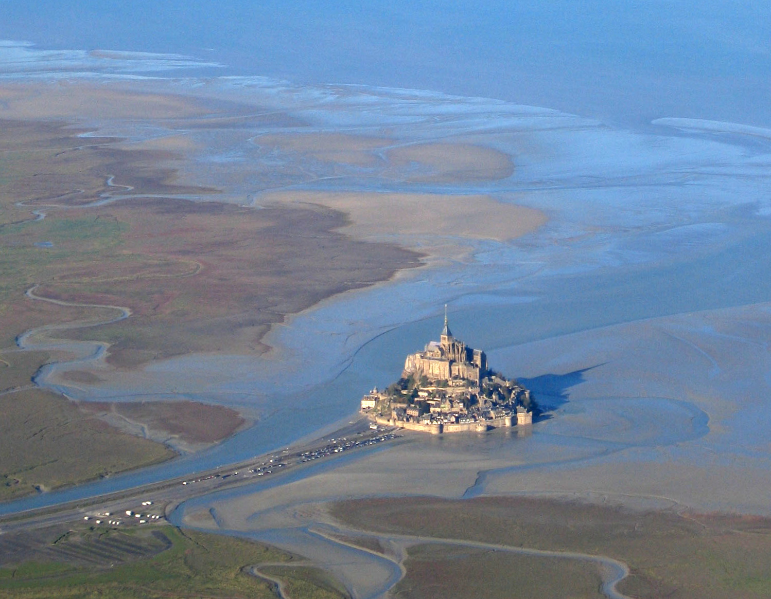
| image | Mont-Saint-Michel vu du ciel.jpg |
| caption | September 2018 view from the southeast at sunrise |
| image coat of arms | Blason ville fr Mont-Saint-Michel (Manche).svg |
| coordinates | |
| arrondissement | Avranches |
| canton | Pontorson |
| intercommunality | Communauté d'agglomération Mont-Saint-Michel-Normandie |
| mayor | Jacques Bono |
| term | 2020–2026 |
| elevation min m | 5 |
| elevation max m | 80 |
| area km2 | 4.00 |
| population | |
| population date | |
| population footnotes | |
| INSEE | 50353 |
| postal code | 50116 |
| child | yes |
| Part_of | Mont-Saint-Michel and its Bay |
| Criteria | Cultural: i, iii, vi |
| ID | 80 |
| Year | 1979 |
| Area | 6560 ha |
| Buffer_zone | 57510 ha |
|image coat of arms = Blason ville fr Mont-Saint-Michel (Manche).svg
Mont-Saint-Michel (; Norman: Mont Saint Miché; ) is a tidal island and mainland commune in Normandy, France.
The island lies approximately 1 km off France's north-western coast, at the mouth of the Couesnon River near Avranches and is 7 ha in area. The mainland part of the commune is 393 ha in area so that the total surface of the commune is 400 ha. , the island has a population of 29.
The commune's position—on an island just a few hundred metres from land—made it accessible at low tide to the many pilgrims to its abbey, and defensible as the incoming tide stranded, drove off, or drowned threats on foot. The island remained unconquered during the Hundred Years' War. A small garrison fended off a full attack by the English in 1433. Louis XI recognised the benefits of its natural defence and turned it into a prison. The abbey was used regularly as a prison during the Ancien Régime.
Mont-Saint-Michel and its surrounding bay were inscribed on the UNESCO list of World Heritage Sites in 1979 for its unique aesthetic and importance as a Catholic site. It is visited by more than three million people each year, and is the most-visited tourist attraction in France outside of Paris. Over 60 buildings within the commune are protected as historical monuments.
Geography
Formation
Now a rocky tidal island, the mount occupied dry land in prehistoric times. As sea levels rose, erosion reshaped the coastal landscape, and several outcrops of granite emerged in the bay, having resisted the wear and tear of the ocean better than the surrounding rocks. These included Lillemer, Mont Dol, Tombelaine (the island just to the north), and Mont Tombe, later called Mont-Saint-Michel.
Mont-Saint-Michel consists of leucogranite which solidified from an underground intrusion of molten magma about , during the Cambrian period, as one of the younger parts of the Mancellian granitic batholith. Early studies of Mont-Saint-Michel by French geologists sometimes describe the leucogranite of the Mont as "granulite", but this granitic meaning of granulite is now obsolete.
The mount has a circumference of about 960 m and its highest point is 92 m above sea level.
Tides
The tides vary greatly, at roughly 14 m between highest and lowest water marks. Popularly nicknamed "St. Michael in peril of the sea" by medieval pilgrims making their way across the flats, the mount can still pose dangers for visitors who avoid the bridge and attempt the hazardous walk across the sands from the neighbouring coast.
Polderisation and occasional flooding have created salt marsh meadows that were found to be ideally suited to grazing sheep. Agneau de pré-salé (), a local specialty that may be found on the menus of restaurants that depend on income from the many visitors to the mount.
Tidal island

The connection between Mont-Saint-Michel and the mainland has changed over the centuries. Previously connected by tidal causeway uncovered only at low tide, this was converted into a raised causeway in 1879, preventing the tide from scouring the silt around the mount. The coastal flats have been polderised to create pastureland, decreasing the distance between the shore and the island, and the Couesnon river has been canalised, reducing the dispersion of the flow of water. These factors have all encouraged silting-up of the bay.
In June 2006, French prime minister Dominique de Villepin and regional authorities announced a €200 million project (Projet Mont-Saint-Michel) to build a hydraulic dam using the waters of the Couesnon and the tides to help remove the accumulated silt, and to make Mont-Saint-Michel an island again. The construction of the dam began in 2009. The project included the removal of the causeway and its visitor car park. Since April 2012, the new car park on the mainland has been located 2.5 km from the island. Visitors can walk or use shuttles to cross the bridge.
In July 2014, the new bridge, by architect Dietmar Feichtinger, was opened to the public. The light bridge allows waters to flow freely around the island and improves the efficiency of the now-operational dam. The bridge, which cost €209 million, was opened by President François Hollande.
On rare occasions, tidal circumstances produce an extremely high "supertide". The new bridge was completely submerged on 21 March 2015 by the highest sea level, a once-in-18-years occurrence, as crowds gathered to snap photos.
History
From the 8th century onward
Before the construction of the first monastic establishment in the 8th century, the island was called Mont Tombe (). According to a legend, the archangel Michael appeared in 708 to Aubert of Avranches, the bishop of Avranches, and instructed him to build a church on the rocky islet.
Unable to defend his kingdom against the assaults of the Vikings, the king of the Franks agreed to grant the Cotentin Peninsula and the Avranchin, including Mont-Saint-Michel traditionally linked to the city of Avranches, to the Bretons in the Treaty of Compiègne. This marked the beginning of a brief period of Breton possession of the Mont. In fact, these lands and Mont-Saint-Michel were never really included in the duchy of Brittany. Around 989–990 these traditional bishoprics, dependent of the archbishopric of Rouen and that had been left vacant during the time of the Viking raids, regained their bishops.
The mount gained strategic significance again in 933 when William I Longsword annexed the Cotentin Peninsula from the weakened Duchy of Brittany. This made the mount definitively part of Normandy, and is depicted in the Bayeux Tapestry, which commemorates the Norman Conquest. Harold Godwinson is pictured on the tapestry rescuing two Norman knights from the quicksand in the tidal flats during the Breton–Norman war. Norman ducal patronage financed the spectacular Norman architecture of the abbey in subsequent centuries.

In 1067, the monastery of Mont-Saint-Michel gave its support to William the Conqueror in his claim to the English throne. This he rewarded with properties and grounds on the English side of the Channel, including a small island off the southwestern coast of Cornwall which was modelled after Mont-Saint-Michel and became a Norman priory named St Michael's Mount of Penzance.

During the Hundred Years' War, English forces unsuccessfully besieged Mont-Saint-Michel (which was under French control) twice. The first siege started in 1423, and was lifted the next year. In 1433, an English force equipped with wrought-iron bombards and under the command of Thomas Scales, 7th Baron Scales again besieged the island. It was likewise lifted the next year. Scales's men abandoned two bombards they had used during the siege on 17 June 1434; they were recovered by the French and are currently on display.
When Louis XI of France founded the Order of Saint Michael in 1469, he intended that the abbey church of Mont-Saint-Michel become the chapel for the order, but because of its great distance from Paris, his intention could never be realized.
The wealth and influence of the abbey extended to many daughter foundations, including St Michael's Mount in Cornwall. Its popularity and prestige as a centre of pilgrimage waned with the Reformation, and by the time of the French Revolution there were scarcely any monks in residence. The abbey was closed and converted into a prison, initially to hold clerical opponents of the republican regime. High-profile political prisoners followed. By 1836, influential figures—including Victor Hugo—had launched a campaign to restore what was seen as a national architectural treasure. The prison was closed in 1863.
In 1872, French architect of historic monuments Édouard Corroyer was responsible for assessing the condition of Mont-Saint-Michel. It took him about two years to convince his minister to classify it as a historic monument, and it was officially declared as such in 1874. From then on Corroyer, a member of the Academy of Fine Arts, devoted fifteen years of his life to the restoration of "la Merveille". Under his direction, gigantic works were undertaken, starting with the most urgent. He wrote four works on the building.
During the occupation of France in World War II, German soldiers occupied Mont-Saint-Michel, where they used St. Aubert church as a lookout post. The island was a major attraction for German tourists and soldiers, with around 325,000 German tourists from July 18, 1940, to the end of the occupation of France.
After the Allies' initial D-Day invasion of Normandy that began on June 6, 1944, many exhausted German soldiers retreated to strongholds like Mont-Saint-Michel. On August 1, 1944, a single American soldier – Private Freeman Brougher of Pennsylvania and the 72nd Publicity Service Battalion – reached and liberated Mont-Saint-Michel accompanied by two British reporters, Gault MacGowan of the New York Sun and Paul Holt with the London Daily Express. Jubilant crowds of locals greeted Brougher, Holt and MacGowan, and Brougher signed the Golden Book, the island's record of visiting nobility, at the mayor's invitation. The abbey was also used as a prison for the first time since the French Revolution when male collaborators with the Germans were jailed there.
Mont-Saint-Michel and its bay were added to the UNESCO list of World Heritage Sites in 1979, listed with criteria such as cultural, historical, and architectural significance, as well as human-created and natural beauty.

In June 2023, President Emmanuel Macron visited Mont-Saint-Michel to mark the 1,000-year anniversary of the abbey. He stated that the changes since the hydraulic dam and the new bridge opened have lessened the silting, making it an island again.
Abbey design

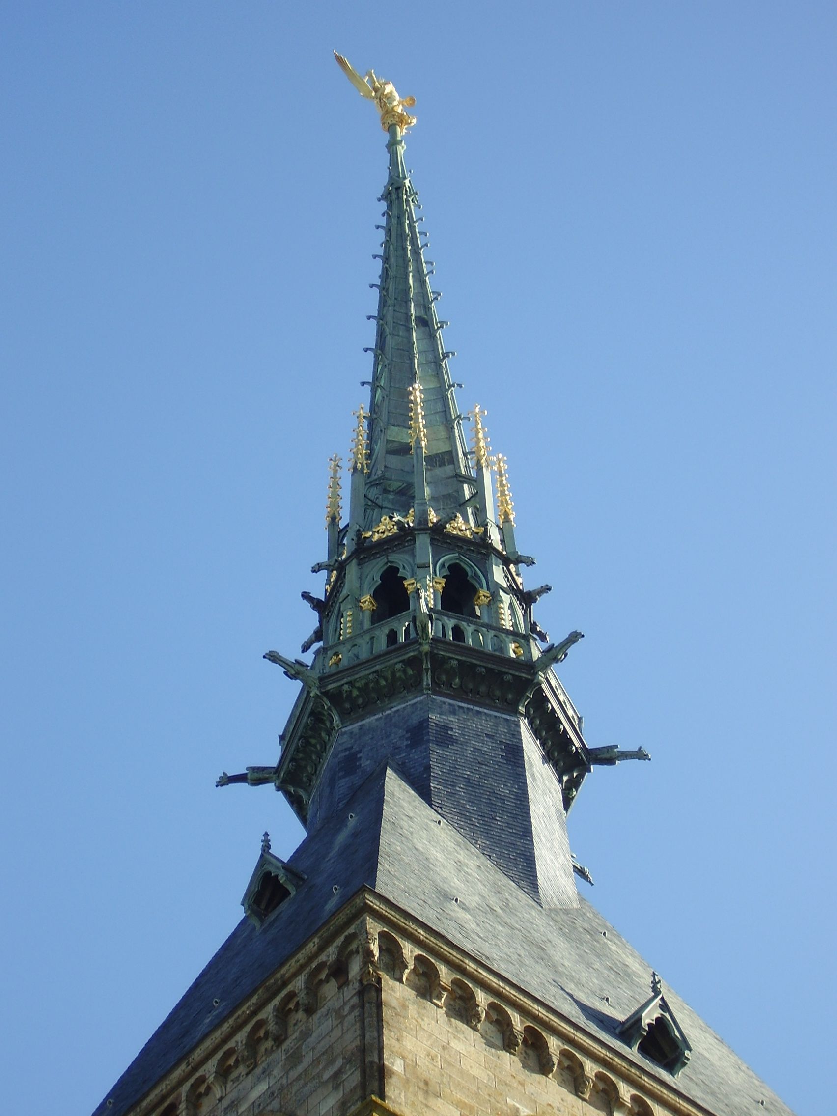
In the 11th century, William of Volpiano, the Italian architect who had built Fécamp Abbey in Normandy, was chosen by Richard II, Duke of Normandy, to be the building contractor. He designed the Romanesque church of the abbey, daringly placing the transept crossing at the top of the mount. Many underground crypts and chapels had to be built to compensate for this weight. These formed the basis for the supportive upward structure that can be seen today. Today Mont-Saint-Michel is seen as a building of Romanesque architecture.
Robert de Thorigny, a great supporter of Henry II of England, who was also Duke of Normandy, reinforced the structure of the buildings and built the main façade of the church in the 12th century. In 1204, Guy of Thouars, regent for the Duchess of Brittany, as vassal of the King of France, undertook a siege of the Mount. After setting fire to the village and massacring the population, he beat a retreat under the powerful walls of the abbey. The fire which he lit extended to the buildings, and the roofs fell prey to the flames. Horrified by the cruelty of his Breton ally, Philip Augustus offered Abbot Jordan a grant for the reconstruction of the abbey in the new Gothic architectural style.
Charles VI is credited with adding major fortifications to the abbey-mount, building towers, successive courtyards, and strengthening the ramparts.
Development
File:200506 - Mont Saint-Michel 50 - Maquette.JPG|10th century File:200506 - Mont Saint-Michel 51 - Maquette.JPG|11th to 12th century File:200506 - Mont Saint-Michel 52 - Maquette.JPG|17th to 18th century File:200506 - Mont Saint-Michel 53 - Maquette.JPG|19th to 21st century
Administration

The islet belongs to the French commune of Le Mont-Saint-Michel, in the département of Manche, in Normandy. The nearest significant town, with an SNCF train station, is Pontorson, with a population of slightly over 4,000. Mont-Saint-Michel belongs to the Organization of World Heritage Cities.
Population
.jpg)
|1793| 234 |1800| 234 |1806| 282 |1821| 304 |1831| 390 |1836| 385 |1841| 1082 |1846| 1100 |1851| 1182 |1856| 1153 |1861| 1056 |1866| 203 |1872| 193 |1876| 184 |1881| 209 |1886| 211 |1891| 199 |1896| 230 |1901| 235 |1906| 238 |1911| 232 |1921| 230 |1926| 247 |1931| 250 |1936| 231 |1946| 186 |1954| 268 |1962| 132 |1968| 105 |1975| 114 |1982| 80 |1990| 72 |1999| 46 |2007| 41 |2012| 41 |2017| 30
| 1956–1962 | 1962–1968 | 1968–1975 | 1975–1982 | 1982–1990 | 1990–1999 |
|---|---|---|---|---|---|
| xx | 13 | 16 | 8 | 6 | 4 |
| 1956–1962 | 1962–1968 | 1968–1975 | 1975–1982 | 1982–1990 | 1990–1999 |
|---|---|---|---|---|---|
| xx | 6 | 6 | 4 | 5 | 3 |
The Monastic Fraternities of Jerusalem
Since June 2001, following the appeal addressed to them in 2000 by Jacques Fihey, Bishop of Coutances and Avranches, a community of monks and nuns of the Monastic Fraternities of Jerusalem, sent from the mother-house of St-Gervais-et-St-Protais in Paris, have been living as a community on Mont-Saint-Michel. They replaced the Benedictine monks who returned to the mount in 1966. They are tenants of the centre for national monuments and are not involved in the management of the abbey.
The community has seven sisters and four brothers. Their life revolves around prayer, work and fraternal life. The community meets four times a day to recite the liturgical office in the abbey, or in the crypt of Notre-Dame des Trente Cierges in winter. In 2012, the community undertook the renovation of a house on the mount, the Logis Saint-Abraham, which is used as a guest house for pilgrims on retreat.
Dolphins in the bay
In summer, dolphins from the warmer waters of the Atlantic Ocean follow the ocean currents to play around the local fishermen's traditional boats, the famous motorised barquettes. These small boats are about 5 metres long and 2 metres wide, typically with low-powered motors. The rotation of their propellers makes a smooth current attractive to the dolphins. Also, dolphins which have a very good memory know that the fishermen around the Mont-Saint-Michel are friendly to them and never harmful. Due to this, these dolphins approach the boats and play around them, offering a splendid spectacle.
People and places of note
- Robert of Torigni, famous abbot of the mount;
- The Duke of Chartres (later Louis-Philippe I) came to demolish the "iron cage";
- Louis Auguste Blanqui, political prisoner in the mount;
- Armand Barbès, political prisoner in the mount;
- La Mère Poulard, famous restaurant;
- Anne Boutiaut Poulard, creator of the Omelette de la mère Poulard.
- Tiphaine Raguenel, Breton noblewoman and astrologer.
Economy
The Mont-Saint-Michel has long been dominated by a handful of families which shared the businesses in the town and ran the village administration. Tourism is almost the sole source of income of the commune, bringing US$63 million to the small island in 2014. There are about 50 shops for three million tourists. The island is also home to four museums, showcasing the history, culture, and heritage of Mont-Saint-Michel. About 25 people sleep every night on the mount, monks included, except for those in hotels. There are 132 hotel rooms within the island's walls. The main institutions are shared by:
- Eric Vannier, owner of the group Mère Poulard (holding half of restaurants, shops, hotels and three museums);
- Jean-Yves Vételé, CEO of Sodetour (five hotels, a supermarket and shops—all extramural—including Mercury Barracks);
- Patrick Gaul, former elected official, hotelier and intramural restaurateur;
- Independent merchants. Overtourism is a problem for Mont-Saint-Michel, exacerbated by tourists mostly visiting on day-trips, which causes overcrowding from 10:00 to 16:00, especially in the summer. The Mont-Saint-Michel foundation has introduced measures to change this pattern and reduce daytime overcrowding, including by introducing free parking after 18:30, except during July and August.
The nearest airports to Mont-Saint-Michel are Rennes–Saint-Jacques Airport, located 88 km south and Nantes Atlantique Airport, located 198 km south.
Twin towns and sister cities
- Hatsukaichi, Hiroshima, Japan, where Itsukushima Shrine, another UNESCO World Heritage Site, is located.
Historically, Mont-Saint-Michel was the Norman counterpart of St Michael's Mount in Cornwall, England, which was given to the Benedictines, the religious order of Mont-Saint-Michel, by Edward the Confessor in the 11th century. The two mounts share the same tidal island characteristics and a similar conical shape, though Mont-Saint-Michel is much taller.
Modern pilgrimage
During the medieval period, pilgrims walked from Italy, Germany and England, as well as other parts of France. Such devotees were known as Miquelots. Modern pilgrims can follow the same routes. Ten hiking trails have been created that enable pilgrims from various European countries to retrace the path their ancestors may have taken during a medieval pilgrimage.
In popular culture

_-_Mont_St_Michel_-_NG_2832_-_National_Galleries_of_Scotland.jpg)
Cinema
Part of the action in Helen MacInnes's 1943 film thriller Assignment in Brittany takes place at the Mont, including a dramatic nighttime chase across the sands. Peter Jackson is said to have taken inspiration from Mont-Saint-Michel in designing Gondor's capital city, Minas Tirith, in his 2003 film The Lord of the Rings: The Return of the King.
The Kingdom of Corona in the 2010 Disney film Tangled is based on Mont-Saint-Michel.
Monte-Saint-Michel was also featured in the final episode of the first season of The Walking Dead: Daryl Dixon as well as the second season.
Mindwalk is a 1990 feature film directed by Bernt Capra, adapted from his short story based on The Turning Point, a nonfiction book by physicist Fritjof Capra, his brother. The movie was filmed on site at the Mont Saint-Michel and has views of (and scenes conceptually based around) many structures and features there, including the approach over the tidal flats, the cathedral, the walkways, a torture chamber, and a giant, ancient clock mechanism. The film portrays a wide-ranging conversation among three characters: Sonia, a Norwegian physicist who abandoned a lucrative career after discovering that elements of her work were being applied to weapons development, Jack, an American politician attempting to make sense of his recent defeat as a presidential candidate, and Tom, a poet, Jack's close friend, and a disillusioned former political speechwriter, while they wander around Mont Saint-Michel, Normandy. The film introduces systems theory and systems thinking, along with insights into modern physical theories such as quantum mechanics and particle physics.
Animation
Mont-Saint-Michel makes a brief appearance in the 4th episode of the anime Saint Cecilia and Pastor Lawrence.
Video games
Mont-Saint-Michel is a World Wonder in Civilization VI. Mont-Saint-Michel is featured in Onimusha 3: Demon Siege in which the abbey is overrun by demons in both the 16th and 21st centuries and subsequently destroyed.
A fictionalized version of the island, Beaumont-Saint-Denis, serves as the location for Sniper Elite 5s third mission. The castle is also the inspiration for the site of the climactic final battle in the air combat video game The Sky Crawlers: Innocent Aces, in which it is an abandoned enemy fortress with still-operational anti-air turrets. It also inspires the castle that appears on the cover art of the 1997 video game: Castlevania Symphony of the Night and Dark Souls' New Londo Ruins.
Mont-Saint-Michel serves as an area in Country of the Musketeers in Kingdom Hearts: Dream Drop Distance, where Sora and the Three Musketeers composed of Mickey Mouse, Donald Duck and Goofy attempt to rescue Princess Minnie from Pete.
The map "Corrode" introduced in June 2025 in Valorant takes inspiration from Mont-Saint-Michel.
Music
Mike Oldfield named a song after the island on his 1996 album Voyager.
American musician Quadeca featured the island in the music video for his song "AT A TIME LIKE THIS". The song was included on his 2025 visual album Vanisher, Horizon Scraper.
References
References
- (13 September 2022). "Répertoire national des élus: les maires". data.gouv.fr, Plateforme ouverte des données publiques françaises.
- With two hyphens and the French article "Le" ahead, because it is the name of a commune, not a hill.
- "Commune of Le Mont-Saint-Michel's territory (scale 1:34110), the two mainland zones (enclaves) are visible, surrounded by a yellow line : one on the west of the Couesnon River is a relatively big one (387 ha), the other one on the east of the Couesnon River is a tiny one (6 ha)".
- "Communal limits : the three areas (two of them are on the mainland and the third one is the island itself) are each surrounded by an orange line".
- [https://www.insee.fr/fr/statistiques/fichier/6011070/ensemble.pdf Téléchargement du fichier d'ensemble des populations légales en 2019], [[Institut national de la statistique et des études économiques. INSEE]]
- "Mont Saint-Michel".
- (13 December 2006). "Mont-Saint-Michel and its Bay". United Nations Educational, Scientific, and Cultural Organization.
- (2023-07-26). "Summer overtourism plagues France's historic Mont-Saint-Michel".
- {{Search Mérimée. 50353
- L'Homer, A.. (1999). "Notice explicative, Carte géologique de la France (1/50 000), feuille Baie du mont-Saint-Michel (208)". BRGM.
- "Carnets géologique de Philippe Glangeaud – Glossaire".
- Chantal Bonnot-Courtois, La Baie du Mont-Saint-Michel et l'estuaire de la Rance: environnements sédimentaires, aménagements et évolution récente. Editor Technip. 2002. pp. 15–20.
- "Official website of the restoring operation of the Mont Saint-Michel's maritime character".
- (November 2015). "Mont Saint-Michel reclaims its island status". rfi.
- Galimberti, Katy. (31 March 2015). "Photos: Supertide Turns Mont Saint-Michel into Island in a Once in 18-Year Spectacle". AccuWeather.
- (1911-10-01). "Catholic Encyclopedia: Mont-St-Michel". New Advent.
- Allen, Richard, ''The Norman Episcopate'', 989-1110, University of Glasgow, 2009, fig. 3, p. 14
- James, David. (2017-10-06). "10 Fascinating Facts About Mont Saint-Michel – the Medieval City on a Rock".
- Hymel, Kevin. (January 2021). "Freeing Mont Saint Michel".
- "The Liberation of Mont-Saint-Michel".
- Olive, Noemie. (June 5, 2023). "New dam saved France's Mont-Saint-Michel island status, Macron says". Reuters.
- (1913). "Mont-Saint-Michel and Chartres: A Study of Thirteenth-Century Unity". [[Houghton Mifflin]].
- [https://www.insee.fr/fr/metadonnees/geographie/commune/50353-le-mont-saint-michel Commune du Mont-Saint-Michel (50353)], INSEE
- "Le Mont-Saint-Michel".
- [https://www.insee.fr/fr/statistiques/4515315?geo=COM-50353#ancre-POP_T1 Population en historique depuis 1968], INSEE
- "Mont Saint Michel facts".
- "Les dauphins et Al Lark {{!}} Saint-Malo – Baie du Mont-Saint-Michel – Tourisme".
- "Dauphins Mont-Saint-Michel".
- Stille, Alexander. (June 2014). "The Massive and Controversial Attempt to Preserve One of the World's Most Iconic Islands". Smithsonian Magazine.
- "Museums at Mont Saint-Michel". Mont Saint-Michel Tours.
- (2014). "Le Mont-Saint-Michel – Jumelage". Wikimanche.fr.
- "Nishihiroshima Times". L-co.co.jp.
- (16 May 2009). "Miyajima Grand Hotel Info". Miyajima-arimoto.co.jp.
- Henderson, Charles. (1925). "Cornish Church Guide". Oscar Blackford.
- "The ways of holy Michel mount".
- (27 June 2014). "The real-life Minas Tirith from 'Lord of the Rings': A tour of Mont Saint-Michel". CNET.
- (2013-10-20). "10 Real Life Locations That Inspired Disney Films". buzzfeed.com.
- Parks, William. (2020-06-02). "Civilization 6: Wonder Tier List".
- Mahardy, Mike. (2022-06-20). "Sniper Elite 5 has one of the best sandbox missions I've ever played".
- (19 November 2012). "Translation of the Design Works Interview with Hidetaka Miyazaki". giantbomb.com.
- (4 August 2012). "The Country of the Musketeers - Sora - Kingdom Hearts 3D Guide".
- (2025-06-20). "Pearl and Split are out with new VALORANT map pool rotation in Patch 11.00".
- (25 July 2025). "Quadeca - at a Time Like This".
This article was imported from Wikipedia and is available under the Creative Commons Attribution-ShareAlike 4.0 License. Content has been adapted to SurfDoc format. Original contributors can be found on the article history page.
Ask Mako anything about Mont-Saint-Michel — get instant answers, deeper analysis, and related topics.
Research with MakoFree with your Surf account
Create a free account to save articles, ask Mako questions, and organize your research.
Sign up freeThis content may have been generated or modified by AI. CloudSurf Software LLC is not responsible for the accuracy, completeness, or reliability of AI-generated content. Always verify important information from primary sources.
Report