From Surf Wiki (app.surf) — the open knowledge base
Mole Creek

| Field | Value |
|---|---|
| name | Mole Creek |
| state | tas |
| image | Mole-Creek-Hotel-20070422-026.jpg |
| caption | Mole Creek Hotel and post office. |
| coordinates | |
| pushpin_label_position | right |
| lga | Meander Valley Council |
| postcode | 7304 |
| pop | 609 |
| pop_year | |
| pop_footnotes | |
| elevation | 240 |
| elevation_footnotes | |
| maxtemp | 16.1 |
| maxtemp_footnotes | |
| mintemp | 4.4 |
| mintemp_footnotes | |
| rainfall | 1125 |
| rainfall_footnotes | |
| stategov | Lyons |
| fedgov | Lyons |
| dist1 | 228 |
| dir1 | N |
| location1 | Hobart |
| dist2 | 76 |
| dir2 | W |
| location2 | Launceston |
| dist3 | 25 |
| dir3 | W |
| location3 | Deloraine |
Mole Creek is a town in the upper Mersey Valley, in the central north of Tasmania, Australia. Mole Creek is well known for its honey and accounts for about 35 percent of Tasmania's honey production. The locality is in the Meander Valley Council area, but with about 3% in the Kentish Council LGA.
History
Australian Aboriginals have lived on the island of Tasmania for thousands of years. The earliest archaeological evidence for Aboriginal habitation of Tasmania is from the valley of the Forth River, 35000 years before the present. Prior to European settlement, Mole Creek, along with much of the surrounding area, was part of the lands of the Pallittorre Aboriginal tribe. Their range included Deloraine, the face of the Great Western Tiers, and the Gog mountain range to the north of Mole Creek where they mined ochre in the Toolumbunner ochre pits. There is evidence that they had been settled in the Mole Creek area for at least 10,000 years. As Europeans moved onto their land the two groups came into conflict, many Aboriginal people and some Europeans were killed.
During the 1820s, the Van Diemen's Land Company cut a stock route from Deloraine to Emu Bay (now known as Burnie) via Chudleigh and Mole Creek. Prior to this cattlemen had run cattle and built stockman's huts on the land west of Westbury. From the 1820s onwards land grants began being issued as the land was gradually surveyed. A systemic exploration of Mole Creek and the area west was conducted in 1826 by Edward Curr, Joseph Fossey and Henry Hellyer. Mole Creek was originally a mixture of tall forest, plains and boggy marsh. The land was first held in large leaseholds by the wealthiest in the colony of Tasmania. In the mid-19th century a number of waste lands acts were passed by the government allowing for smaller holdings, opening up the then densely forested land around the town of Mole Creek. Many of these first settlers were farm labourers or ex-convicts, who had worked as labourers or tenant farmers on the larger holdings.
The name Mole Creek comes from a nearby stream, recorded as early as the Land Commissioner's reports' maps from 1826-28. This creek flows above ground, and in portions underground through the caves underlying the area. The caves of the nearby Mole Creek Karst National Park, which include the show caves Marakoopa Cave and King Solomons Cave, have attracted tourists since the 1850s. Their popularity encouraged the establishment of tourist facilities in Mole Creek including Howe's Boarding House and Lee's Mountain View Guest House. By 1876 the town had a water-powered flour mill and water powered saw mill. At the same time a Wesleyan chapel and minister's residence were being constructed. A post office opened on 28 May 1884 though the town remained small. A former resident remembered Mole Creek in the 1890s as "a small bush settlement". Lime kilns were built at Mole Creek in the late 19th century, taking advantage of the extensive limestone in the area.
20th century
In the early 20th century the opening of some scenic caves for tourism lead to further development in the town. King Solomon's Cave was discovered in 1906 and opened for tours in 1908. Marakoopa cave was found in 1910, opened in 1912 and sold to the state tourist department in 1919. Edward Charles James, who had obtained a lease on King Solomon's Cave, built what is now the Mole creek hotel over 1907-8 as a 30-room guest house. Due to some unusual sale conditions he could not serve alcohol. The building was sold in 1910 to George Lee who ran it as the Mountain View Guest House. A grocery and hardware shop ran from part of the building from 1929 to 1965. In June 1953 the sale conditions were overcome and a licence to serve alcohol was granted.The history of the hotel's use is recorded in a commemorative sign in its lobby
Robert Stephens had kept bees as a hobby. After he returned from service in World War I he continued his interest. He opened a commercial honey production facility in Mole Creek in 1918. By 1923 the factory had 50 hives and was selling honey under the Golden Bee brand. Since 1951 it has concentrated on leatherwood honey. Each year hives are transported to Tasmania's west coast to make honey with the distinctive flavour of leatherwood (Eucryphia lucida and Eucryphia milliganii). The Factory and Apiary are provisionally registered on the Tasmanian Heritage Register. It has operated on the same 2 acre site since operations began; the oldest building is a c.1920 timber cottage and the prominent façade that faces the main road dates from the 1970s. The factory is run by Stephen's decedents using the "Golden Bee" label introduced in 1930 and the "Golden Nectar" label for leatherwood honey introduced 1951. As of 2010 it was producing 350 tonne of honey each year and approximately 35% of all Tasmanian honey.
Electricity, supplied by the Hydroelectric Commission, reached Mole Creek in 1936 and street lighting was installed soon after. Construction of a memorial hall began at the end of 1950, funded by a state government grant of 1000 pounds. A driving force behind construction was the school's lack of a recreation hall forcing them to on occasion rent the Methodist Hall. The Mole Creek bush nursing centre was opened in mid-1944. and came under control of the Launceston Public Hospitals District Board in 1968. The site is now a health centre housing the Mole Creek Child Health Centre and is operated by the Department of Health and Human Services.
Railway
A rail line was opened in 1890. It ran 20.4 km and by 1900 there was no longer an expectation that the line would be extended to Tasmania's west coast. Throughout its existence, it carried mostly timber destined for the paper mill at Burnie and, in later days, woodchips for Bell Bay. From the 1920s passenger services, which on occasion ran as far as Devonport, were mostly conducted by railcars. From the 1970s to the 1980s the track saw extensive use transporting limestone to South Burnie. The rail extension was closed in 1985 and the track lifted in 1992.
Religion
The Deloraine Wesleyan district decided, in 1875, to erect a chapel in Mole creek. Construction began on the Methodist (Wesleyan) church, on donated land, and an associated cottage in late 1876. It was completed in 1878, then enlarged in 1880, at which time the original building was moved to the rear and used as a supper room. An adjacent church hall was added in 1919. A new parsonage was built and opened in 1956 but was subsequently sold to Forestry Tasmania in 1972. In 1976, along with most Methodist churches in Australia, it became part of the Uniting Church in Australia. It was still used as of 1996 but was subsequently closed and sold.Online sale records date the closure to prior to 2009.
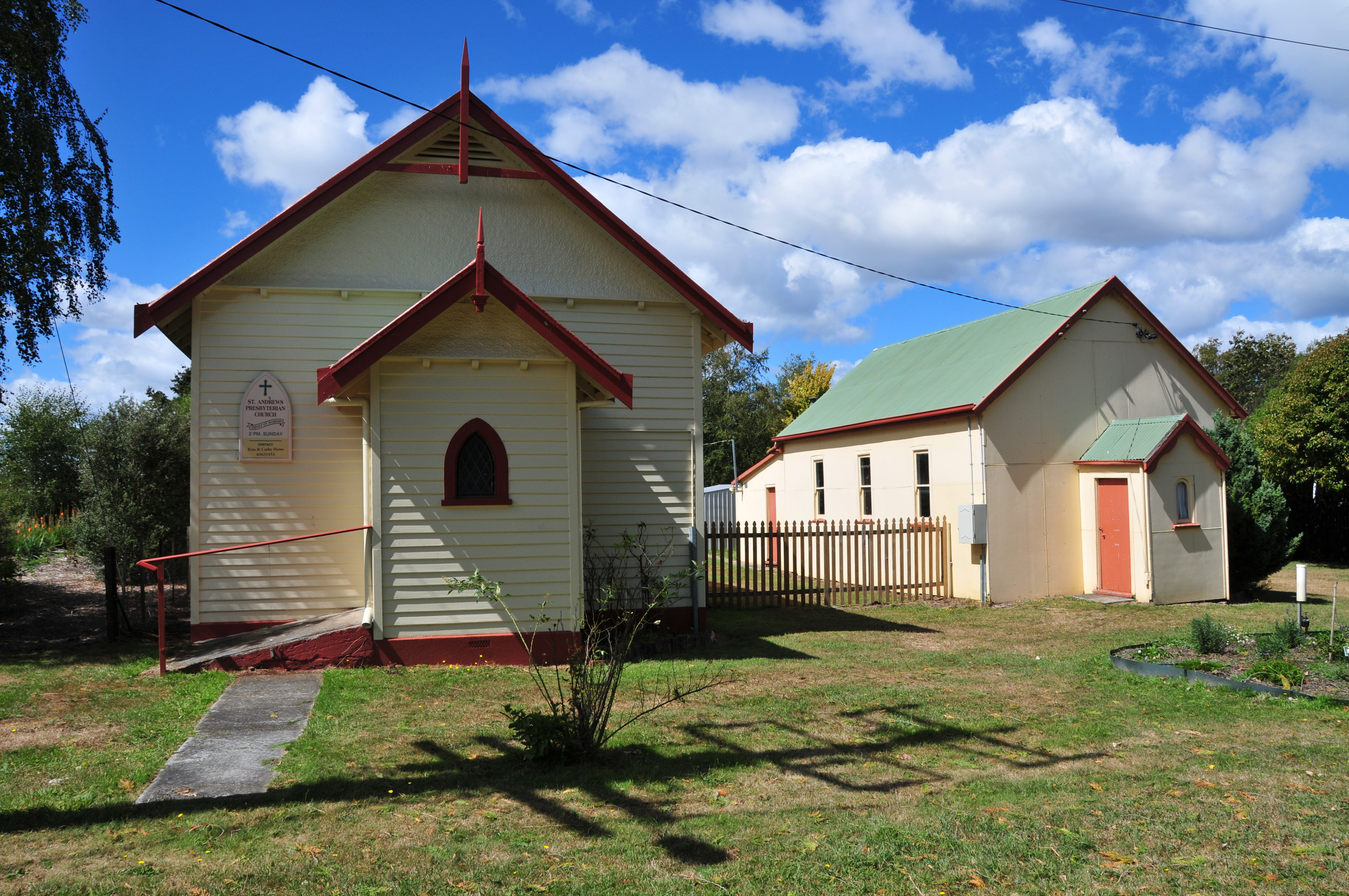
A news report in 1900 reports that, in addition to the Wesleyan weatherboard church, there was a Baptist church and in 1905 the town had a Seventh-day Adventist church. In the 19th century Anglican services were held in the Wesleyan chapel. St Colombia's Anglican church was built in Mole Creek and dedicated in September 1902 by Bishop Henry Montgomery and Gilbert White, a missionary. The church was in the parish of Deloraine and was closed in the early 1990s. Mole Creek's only remaining church is part of the Presbyterian Church of Tasmania, in the Presbytery of Bass. St Andrew's church was consecrated 12 September 1932. It celebrated its 40th anniversary in 1972 and remains in use.
Geography and climate
The town of Mole Creek lies at 240 m above sea level. The Mole Creek-Chudleigh karst is an area underlain by limestone with underground streams, sinkholes and caves. It was formed when Gondwanaland was covered by a shallow sea approximately 500 million years ago. The area has a layer of Ordovician limestone, approximately 100 m thick covering an area 26 by, and other sedimentary rocks. The town is surrounded by a plain underlain by this limestone which crops up through the overlying sediments. Nearby hills have prominent basalt, limestone and dolerite depending on location. The flats are of alluvial origin with Permian sediments formed from mudstone and sandstone. The karst is riddled with over 400 caves and sinkholes, some of which are open to the public. King Solomon's Cave and the Marakoopa Caves became part of a state cave reserve in 1939. The caves and many other parts of the karst became part of the Mole Creek Karst National Park when it was formed in 1996. The agricultural land around Mole Creek is mostly suited to grazing, intensive in some areas, though some is marginal cropping land that requires careful crop rotation with seasons where the land must be left fallow. Mole creek has a cool temperate climate. The average rainfall of 1125 mm1,122mm of average rainfall is derived from weather records over 1914 to 2015 is significantly higher than parts of the Meander Valley Council area further to the east. The average rainfall has noticeably declined over the past 3-4 decades.{{Weather box
School
Mole Creek Primary school is a government school for students from kindergarten to grade 6 that has, as of 2015, 76 students. It was changed to a district or area school in 1936. A single-room school building, and associated teacher's residence, had been constructed over 1892–93 in Caveside. When the school was closed in 1937 the building was moved to Mole Creek in 1938 and used for 'domestic arts' at school. Western Creek, near Meander, had a school from 1893 to 1938. After it closed some students attended Meander's school, but others moved to schools at Mole Creek and Deloraine. This school building was also moved and added to those at Mole Creek's school. The primary school services surrounding districts including Chudleigh and Caveside. The nearest high school is in Deloraine.
Current town
The town is named after Mole Creek, a tributary of the Mersey River. This creek is named due to the way that it appears above ground, descends below ground into the limestone cave system, then reappears multiple times. The main industries in the area are forestry, farming, limestone mining and the R Stephen's honey factory. One of the largest non-farm employers in the area is Unimim Lime Limited. They quarry and process limestone to make quicklime and hydrated lime. As of 2007 they employed 28 people at Mole Creek Mole Creek is well known for its honey and accounts for about 35 percent of Tasmania's honey production including Leatherwood honey—a noted monofloral honey—which is unique to Tasmania and sold internationally.
Nearby is the Mole Creek Karst National Park, which includes the show caves Marakoopa Cave and King Solomons Cave. These caves have been popular with tourists for over 100 years. Trowunna Wildlife Park is a 65 acre private sanctuary a short distance on the main road towards Chudleigh. The park contains native Australian animals both in enclosures and free-ranging. It works as part of the effort to preserve Tasmanian devils by keeping a population that are free of facial tumour disease, and runs as a training centre for animal handling and animal keeping. Other animals at the park include spotted-tail quolls, eastern quolls, wombats, grey kangaroos, red-necked wallabies, pademelons, potoroos, bettongs, bandicoots, pygmy possums, wedge-tailed eagles, brown falcons, goshawks, owls, green rosellas, black swans, ducks, honeyeaters, wrens and robins.
Mole Creek has a volunteer fire brigade. It first ran from 1956 to 1962 and was disbanded due to lack of local interest. A district brigade and fire station had been re-established by 1970. The town had a cricket club by the early 20th century and an Australian rules football club by 1946. The football club still exists and plays in the Leven Football Association. and remains open. Mole Creek has a hotel, established in 1907, a guest house and restaurant, a swimming pool and adjacent community hall, supermarket, service station, post office and a church.
Mole Creek is in the Meander Valley Council local government area, At the 2011 census, Mole Creek's statistical area—covering 217.2 sqkm—had a population of 609 though the town itself had only 230.
Notes
References
Bibliography
References
- Jupp, p.110
- Jupp, p.111
- Their population in the area has been estimated to drop from 200 to 60 during 1827-30.Australian Garden History Society, pp.1–4
- Evans & Terry, p.9
- Evans & Terry, p.20
- Settlers in the early 19th century cleared the land largely using fire and the [[ring barking]] of trees.Evans & Terry, p.33
- Evans & Terry, p.26
- Evans & Terry, p.11
- Evans & Terry, p.79
- A correspondant. (24 October 1876). "Chudleigh". The Launceston Examiner.
- Green, p.4
- Evans & Terry, p.21
- Sydney, pp.23-24
- Sydney, p.25
- Evans & Terry, p.38
- Holland, pp.117–118
- Sydney, p.5
- (1 December 1950). "Mole Creek". The Advocate.
- Flowers, T.W.. (4 December 1950). "Mole Creek Memorial Hall". The Advocate.
- (16 May 1944). "Bush nursing centre". The Examiner.
- Evans & Terry, p.43
- to Mole Creek, through Chudleigh, from a junction near Deloraine on the [[Western Line, Tasmania. Western Line]]. There was a plan to extend the line further west and government surveyors employed to this end. The survey was cancelled in 1891Evans & Terry, p.32
- The Examiner's Travelling Correspondent. (18 April 1900). "Chudleigh and Mole Creek". The Examiner.
- Stokes, pp.243-252
- (16 November 1875). "Wesleyan district meeting". The Mercury.
- (13 November 1876). "Wesleyan council financial district meeting". The Cornwall Chronicle.
- Mercury Correspondant. (4 February 1884). "Mole Creek". The Mercury.
- Stansall, p.65
- Sydney, p.2
- Travelling Correspondant. (18 April 1900). "Chudleigh and Mole Creek". The Examiner.
- Evans & Terry, p.87
- Henslowe, p.46
- Stephens, p.138
- (12 September 1932). "New Presbyterian church at Mole Creek". The Mercury.
- Miller, p.33
- Davey, p.23
- Lloyd, p.50
- Parks and Wildlife Service, p.13
- Topoclimate Services, pp.25-26
- Lloyd, p.51
- Evans & Terry, p.80
- Topoclimate Services, p.27
- The area is notably frosty in winter and experiences the occasional snowfall.Topoclimate Services, p.24
- There was a state school in Mole Creek by 1900.Evans & Terry, pp.61
- (18 July 1936). "New Mole Creek School". The Advocate.
- Reunion Committee, p.15
- Woods & Pennicott, pp.96–98
- Whitworth, p.136
- "Mole Creek". Meander Valley Council.
- "About us". Mole Creek Progress Association.
- Davey, p.19
- "Mole Creek Karst National Park". Parks and Wildlife Service Tasmania'.
- Evans & Terry, p.55
- Evans & Terry, p.77
- The cricket club plays in the Northern Midlands Cricket Association. The town has a community maintained swimming pool. Mole Creek's cemetery opened in 1916, serving also Caveside,Evans & Terry, p.95
- "Legislative Council Division of Western Tiers". Tasmanian Electoral Commission.
- "Mole Creek Primary School". Department of Education.
- "Federal Electorate: LYONS". Australian Electoral Commission.
- Bourne, Brenda. "Mole Creek".
- "Mole Creek Cemetery". Meander Valley Council.
- (May 2013). "Meander Valley, Directory of Community Services". Meander Valley Council.
- "Monthly mean maximum temperature, Deloraine (Athol)". Bureau of Meteorology.
- "Monthly Rainfall, Mole Creek". Bureau of Meteorology.
- (12 May 2015). "Mole Creek". Meander Valley Council.
- {{Census 2011 AUS
- {{Census 2011 AUS
- Bourne, Brenda. "Mole Creek & Chudleigh".
- Premier Postal History. "Post Office List". Premier Postal Auctions.
- Tasmanian Heritage Council. "R. Stephens Golden Bee Honey Factory".
- Johnstone, David. "Mole Creek Presbyterian Church".
- "The interactive tour of Tasmania, Mole Creek". Tour of Tasmania.
- Haberle, Carol. (8 November 2013). "Trowunna Wildlife Park: Adopt a Wombat". Think Tasmania.
- "Mole Creek Line". Australian Railway Historical Society (Tasmanian Division).
- (31 January 2008). "2006/2007 report for UNIMIN LIME (TASMANIA) P/L, Unimin Australia Limited - Mole Creek Site - Mole Creek, TAS". Department of the Environment.
- "Mole Creek Football Club". Fox Sports Pulse.
- ["Annual report 2010-2011"](http://www.heritage.tas.gov.au/media/pdf/Annual Report 2010-11.pdf). Tasmanian Heritage Council.
This article was imported from Wikipedia and is available under the Creative Commons Attribution-ShareAlike 4.0 License. Content has been adapted to SurfDoc format. Original contributors can be found on the article history page.
Ask Mako anything about Mole Creek — get instant answers, deeper analysis, and related topics.
Research with MakoFree with your Surf account
Create a free account to save articles, ask Mako questions, and organize your research.
Sign up freeThis content may have been generated or modified by AI. CloudSurf Software LLC is not responsible for the accuracy, completeness, or reliability of AI-generated content. Always verify important information from primary sources.
Report