From Surf Wiki (app.surf) — the open knowledge base
Moldavian Plateau
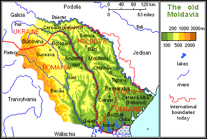
The Moldavian Plateau () is a geographic area of the historical region of Moldavia, spanning nowadays the east and northeast of Romania, most of Moldova (except the south), and most of the Chernivtsi Oblast of Ukraine (where it is known as the Pokuttian-Bessarabian Upland).
Limits
The Moldavian Plateau is bounded (in clockwise order), as follows.
- To the west by the Eastern Carpathian Mountains ().
- To north and north-east by the Podolian Plateau ().
- To the east and south east by Black Sea Lowland across which to the east stretches the Pontic Plain (), part of the Eurasian Steppe () and to the south towards the Black Sea the Bugeac Plain (), comprising 3210 km2 in Moldova.
- To the south by the Romanian Plain (also known as the Wallachian Plain) and the Bărăgan Plain ().
- To the southwest by the Vrancea Hills (), part of the Sub Carpathians (also known as the Curvature Carpathians) ().
The Moldavian Plateau comprises over two-thirds of the territory of the medieval Principality of Moldavia, with the Eastern Carpathian Mountains and the Bugeac Plain representing the remaining part. This fact is the origin of the name of the plateau. This geographic area (including Eastern Carpathians and the Bugeac) is also called (especially by historians) the Carpathian-Dniester-Pontic region, or the Carpathian-Dniester region, since it is bounded by the Carpathians to the west, by the river Dniester to the north and east, and by the Black Sea (Pontus Euxinus) and the Danube to the south-east and south.
Genesis
The Moldavian Plateau was formed at the end of the Neogene through sediments, over an old continental platform, the East European Platform. Afterwards, the settled sediments, which were brought in by rivers from the Carpathian Mountains, were modeled by the elements giving the plateau its current aspect. The materials that formed the sediments are gravel and sand. Hardened, they formed gritstones. All over the plateau, the latter are interspersed with clays, or badlands, which produce landslides or other natural hazards.
The slope of the terrain follows the direction of the rivers: from northwest to southeast. Along them, the altitude decreases from 700 m to under 200 m. The strata are disposed in North-South and northwest-southeast aligned layers, producing asymmetric valleys and ridges. Among the latter are the steep edge of the Bârlad Plateau (), known as the Iași Ridge (), the edge of the Central Moldavian Plateau (), known as the Cornești Hills, and the edge of the Dniester Hills, known as the Dniester Ridge.
The relief in the valleys of the rivers and creeks is quite conspicuous, so that the valleys have large terraces and hillocks. The Siret Passage (), ramified in the north with the Moldova Valley, and Suceava Valley cuts the main part of the plateau from the Moldavian Subcarpathians. The Prut Passage cuts the Plateau in half in the north-south direction. The Dniester Passage bounds it from the Podolian Plateau and the Pontic Plain. Its ramification Răut Passage separates the main part of the Moldavian Plateau from the Dniester Hills
Composition
The Moldavian Plateau comprises several distinct regions:
- The Bukovinian Subcarpathians in the northwest.
- The Moldavian Subcarpathians in the west and southwest, has altitudes of up to 1000 m, but also includes depressions.
- The Suceava Plateau (), situated in the northwest, has altitudes that exceed 700 m and long ridges.
- The Dniester Hills (), also known as Northern Moldavian Plateau (Podişul Moldovei de Nord), situated in the north and northeast, ridges along the Dniester River and has elevations of approximately 300 m.
- The Moldavian Plain (), in the center-north has elevations of approximately 200 m:
- The Jijia Plain, west of the river Prut.
- The Middle Prut Valley, east of the river Prut, creeks tributary to the Prut, 2930 km2.
- The Bălți Steppe, east of the river Prut, creeks tributary to the Dniester, 1920 km2.
- The Bârlad Plateau (), situated in the south-center occasionally has heights over 500 m, but is generally sloped from north at 400 m to the south at 200 m.
- The Central Moldavian Plateau (), situated in the center and southeast, has elevations that in the north-south direction decrease in altitude from 400 m to under 200 m.
- The Bugeac Plain, the last continuation of the Pontic–Caspian steppe.
Climate
The climate of this plateau is transitional Temperate Continental. Overall, the altitude affects the climate, with annual mean temperatures in the Suceava Plateau ranging between 6 °C and 8 °C and precipitation of 500 mm to 800 mm per year and, with annual mean temperatures of 8 °C to 10 °C and precipitation of 400 mm to 500 mm in the Moldavian Plain or Bârlad Plateau.
The main influence on the climate is Dry Continental with frequent cold north winds in winter. In the Suceava Plateau and the Dniester Hills, there is an influence of Scandinavo–Baltic climate with the circulation of masses of polar air in the winter.
Waters
Streams on the plateau flow into the Siret, Prut, or Dniester rivers. The Prut has the Jijia as its principal tributary. The Siret traverses and—with the exception of the Subcarpathians—limits the Moldavian Plateau
The lack of precipitation has required water management in the Jijia Plain and in the Bălți steppe which serves as a reservoir and for fish farming; is the largest of these. Other bodies of water are the rivers Siret and Prut (Lake Stânca-Costești, {{ill|Lake Dubăsari|ro| Lacul de acumulare Dubăsari}}), in the Siret Passage.
Natural resources
The Moldavian Plateau holds hydrocarbon resources (petroleum and the associated gases), which are extracted in the southwest portion. In the northwest are found Romania's most important reserves of kaolin (china clay), extracted and used to produce porcelain.
Hemp is cultivated in the Suceava Plateau, cereals and wine grapes (Vitis vinifera) in the Jijia Plain, Bălți Steppe, Bârlad Plateau, and the Central Moldavian Plateau. In the Siret Passage they cultivate potatoes and sugar beets. Masa lemnoasă este valorificată în Podișul Sucevei, mai bine împădurit. --
Soil
The surface of the soil se succede de la clasa molisolurilor cu tipul cernoziom levigat (in the Jijia Plain and Bălți steppe), la clasa argiluvilsolurilor cu tipurile cenușiu și brun–roșcat.
Vegetation
Asociaţiile vegetale aparţin silvostepei, greatly transformed by agriculture. Toward the northeastern half of the region, silvostepa este înlocuită cu pâlcuri de woods of oak or beech. --
Fauna
Characteristic of the plateau are mammals such as goats, wild boars, wolves, foxes, European wildcats, lynxes, badgers, and hares. Birds include black grouse, woodpeckers, cuckoos, pheasants, quails, hawks, owls, and fish include perch and the carp-like barbel. Numeroase sunt hazardele unităţii: viiturile in spring, viscolele in winter, frecventele alunecări de teren, degradarea solurilor, seceta etc. Man contributes la declanșarea și sporirea acestora prin defrișări, desţeleniri, excessively grazed pastures, air pollution, water pollution, etc. --
References
References
- link. (August 14, 2015 at [[Encyclopedia of Ukraine]].)
- (1 January 2019). "Natural hazards and their impact on rural settlements in NE Romania – A cartographical approach". [[Open Geosciences]].
This article was imported from Wikipedia and is available under the Creative Commons Attribution-ShareAlike 4.0 License. Content has been adapted to SurfDoc format. Original contributors can be found on the article history page.
Ask Mako anything about Moldavian Plateau — get instant answers, deeper analysis, and related topics.
Research with MakoFree with your Surf account
Create a free account to save articles, ask Mako questions, and organize your research.
Sign up freeThis content may have been generated or modified by AI. CloudSurf Software LLC is not responsible for the accuracy, completeness, or reliability of AI-generated content. Always verify important information from primary sources.
Report