From Surf Wiki (app.surf) — the open knowledge base
Moderate Resolution Imaging Spectroradiometer
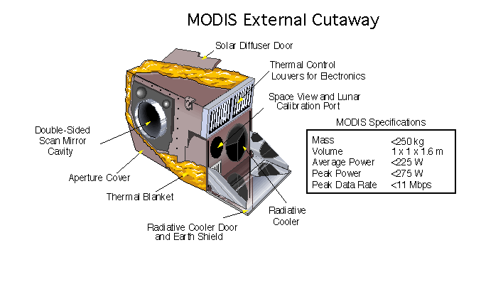
Payload imaging sensor

Payload imaging sensor


The Moderate Resolution Imaging Spectroradiometer (MODIS) is a satellite-based sensor used for earth and climate measurements. There are two MODIS sensors in Earth orbit: one on board the Terra (EOS AM) satellite, launched by NASA in 1999; and one on board the Aqua (EOS PM) satellite, launched in 2002. Since 2011, MODIS operations have been supplemented by VIIRS sensors, such as the one aboard Suomi NPP. The systems often conduct similar operations due to their similar designs and orbits (with VIIRS data systems designed to be compatible with MODIS), though they have subtle differences contributing to similar but not identical uses.
The MODIS instruments were built by Santa Barbara Remote Sensing. They capture data in 36 spectral bands ranging in wavelength from 0.4 μm to 14.4 μm and at varying spatial resolutions (2 bands at 250 m, 5 bands at 500 m and 29 bands at 1 km). Together the instruments image the entire Earth every 1 to 2 days. They are designed to provide measurements in large-scale global dynamics including changes in Earth's cloud cover, radiation budget and processes occurring in the oceans, on land, and in the lower atmosphere.
Support and calibration is provided by the MODIS characterization support team (MCST).
Applications
With its high temporal resolution although low spatial resolution, MODIS data are useful to track changes in the landscape over time. Examples of such applications are the monitoring of vegetation health by means of time-series analyses with vegetation indices, long term land cover changes (e.g. to monitor deforestation rates), global snow cover trends, water inundation from pluvial, riverine, or sea level rise flooding in coastal areas, change of water levels of major lakes such as the Aral Sea, and the detection and mapping of wildland fires in the United States. The United States Forest Service's Remote Sensing Applications Center analyzes MODIS imagery on a continuous basis to provide information for the management and suppression of wildfires.
Specifications
| Specifications | Dimensions |
|---|---|
| Orbit | 705 m, 10:30 a.m. descending node (Terra) or 1:30 p.m. ascending node (Aqua), Sun-synchronous, near-polar, circular |
| Scan rate | 20.3 rpm, cross track |
| Swath | 2330 km (cross track) by 10 km (along track at nadir) |
| Telescope | 17.78 cm diam. off-axis, afocal (collimated), with intermediate field stop |
| Size | 1.0 × 1.6 × 1.0 m |
| Weight | 228.7 kg |
| Power | 162.5 W (single orbit average) |
| Data rate | 10.6 Mbit/s (peak daytime); 6.1 Mbit/s (orbital average) |
| Quantization | 12 bits |
| Spatial resolution | 250 m (bands 1–2) 500 m (bands 3–7) 1000 m (bands 8–36) |
| Temporal resolution | 1–2 days |
| Design life | 6 years |
Calibration
MODIS utilizes four on-board calibrators in addition to the space view in order to provide in-flight calibration: solar diffuser (SD), solar diffuser stability monitor (SDSM), spectral radiometric calibration assembly (SRCA), and a v-groove black body. MODIS has used the marine optical buoy for vicarious calibration.
MODIS bands
| Band | Wavelength | |||||||||
|---|---|---|---|---|---|---|---|---|---|---|
| (nm) | Resolution | |||||||||
| (m) | Primary use | Band | Wavelength | |||||||
| (μm) | Resolution | |||||||||
| (m) | Primary use | |||||||||
| 1 | 620–670 | 250 | Land/cloud/aerosols | |||||||
| boundaries | ||||||||||
| 2 | 841–876 | 250 | ||||||||
| 3 | 459–479 | 500 | Land/cloud/aerosols | |||||||
| properties | ||||||||||
| 4 | 545–565 | 500 | ||||||||
| 5 | 1230–1250 | 500 | ||||||||
| 6 | 1628–1652 | 500 | ||||||||
| 7 | 2105–2155 | 500 | ||||||||
| 8 | 405–420 | 1000 | Ocean color/ | |||||||
| phytoplankton/ | ||||||||||
| biogeochemistry | ||||||||||
| 9 | 438–448 | 1000 | ||||||||
| 10 | 483–493 | 1000 | ||||||||
| 11 | 526–536 | 1000 | ||||||||
| 12 | 546–556 | 1000 | ||||||||
| 13 | 662–672 | 1000 | ||||||||
| 14 | 673–683 | 1000 | ||||||||
| 15 | 743–753 | 1000 | ||||||||
| 16 | 862–877 | 1000 | ||||||||
| 17 | 890–920 | 1000 | Atmospheric | |||||||
| water vapor | ||||||||||
| 18 | 931–941 | 1000 | ||||||||
| 19 | 915–965 | 1000 | ||||||||
| 20 | 3.660–3.840 | 1000 | Surface/cloud | |||||||
| temperature | ||||||||||
| 21 | 3.929–3.989 | 1000 | ||||||||
| 22 | 3.929–3.989 | 1000 | ||||||||
| 23 | 4.020–4.080 | 1000 | ||||||||
| 24 | 4.433–4.498 | 1000 | Atmospheric | |||||||
| temperature | ||||||||||
| 25 | 4.482–4.549 | 1000 | ||||||||
| 26 | 1.360–1.390 | 1000 | Cirrus clouds | |||||||
| water vapor | ||||||||||
| 27 | 6.535–6.895 | 1000 | ||||||||
| 28 | 7.175–7.475 | 1000 | ||||||||
| 29 | 8.400–8.700 | 1000 | Cloud properties | |||||||
| 30 | 9.580–9.880 | 1000 | Ozone | |||||||
| 31 | 10.780–11.280 | 1000 | Surface/cloud | |||||||
| temperature | ||||||||||
| 32 | 11.770–12.270 | 1000 | ||||||||
| 33 | 13.185–13.485 | 1000 | Cloud top | |||||||
| altitude | ||||||||||
| 34 | 13.485–13.785 | 1000 | ||||||||
| 35 | 13.785–14.085 | 1000 | ||||||||
| 36 | 14.085–14.385 | 1000 |
MODIS data
MODIS Level 3 datasets
The following MODIS Level 3 (L3) datasets are available from NASA, as processed by the Collection 5 software.
| Daily | 8-day | 16-day | 32-day | Monthly | Yearly | Grid | Platform | Description |
|---|---|---|---|---|---|---|---|---|
| MxD08_D3 | MxD08_E3 | — | — | MxD08_M3 | — | 1° CMG | Terra, Aqua | Aerosol, cloud water vapor, ozone |
| MxD10A1 | MxD10A2 | — | — | — | — | 500 m SIN | Terra, Aqua | Snow cover |
| MxD11A1 | MxD11A2 | — | — | — | — | 1000 m SIN | Terra, Aqua | Land surface temperature/emissivity |
| MxD11B1 | — | — | — | — | — | 6000 m SIN | Terra, Aqua | Land surface temperature/emissivity |
| MxD11C1 | MxD11C2 | — | — | MxD11C3 | — | 0.05° CMG | Terra, Aqua | Land surface temperature/emissivity |
| — | — | MxD13C1 | — | MxD13C2 | — | 0.05° CMG | Terra, Aqua | Vegetation indices |
| MxD14A1 | MxD14A2 | — | — | — | — | 1000 m SIN | Terra, Aqua | Thermal anomalies, fire |
| — | — | — | — | MCD45A1 | — | 500 m SIN | Terra+Aqua | Burned area |
| 250 m SIN | 500 m SIN | 1000 m SIN | 0.05° CMG | 1° CMG | Time window | Platform | Description |
|---|---|---|---|---|---|---|---|
| MxD09Q1 | MxD09A1 | — | — | — | 8-day | Terra, Aqua | Surface reflectance |
| — | — | — | MxD09CMG | — | Daily | Terra, Aqua | Surface reflectance |
| — | MCD12Q1 | — | MCD12C1 | — | Yearly | Terra+Aqua | Land cover type |
| — | MCD12Q2 | — | — | — | Yearly | Terra+Aqua | Land cover dynamics |
| MxD13Q1 | MxD13A1 | MxD13A2 | MxD13C1 | — | 16-day | Terra, Aqua | Vegetation indices |
| — | — | MxD13A3 | MxD13C2 | — | Monthly | Terra, Aqua | Vegetation indices |
| — | MCD43A1 | MCD43B1 | MCD43C1 | — | 16-day | Terra+Aqua | BRDF/albedo model parameters |
| — | MCD43A3 | MCD43B3 | MCD43C3 | — | 16-day | Terra+Aqua | Albedo |
| — | MCD43A4 | MCD43B4 | MCD43C4 | — | 16-day | Terra+Aqua | Nadir BRDF-adjusted reflectance |
References
References
- "VIIRS; Visible Infrared Imaging Radiometer Suite". NASA.
- "Detecting forest fires with satellites (MODIS and VIIRS)". UN Office for Outer Space Affairs.
- "MODIS Components".
- "MODIS Characterization Support Team".
- LU, L., KUENZER, C., WANG, C., GUO, H., Li, Q., 2015: Evaluation of three MODIS-derived Vegetation Index Time Series for Dry land Vegetation Dynamics Monitoring. Remote Sensing, 2015, 7, 7597–7614; doi:10.3390/rs70607597
- LEINENKUGEL; P., WOLTERS, M., OPPELT, N., KUENZER, C., 2014: Tree cover and forest cover dynamics in the Mekong Basin from 2001 to 2011. Remote Sensing of Environment, Vol. 158, 376–392
- KLEIN, I., GESSNER, U. and C. KUENZER, 2012: Regional land cover mapping in Central Asia using MODIS time series. Applied Geography 35, 1–16
- LU, L., KUENZER, C., GUO, H., Li, Q., LONG, T., LI, X., 2014: A Novel Land Cover Classification Map Based on MODIS Time-series in Nanjing, China. Remote Sensing, 6, 3387–3408; doi:10.3390/rs6043387
- GESSNER, U.; MACHWITZ, M.; ESCH, T.; TILLACK, A.; NAEIMI, V.; KUENZER, C.; DECH, S. (2015): Multi-sensor mapping of West African land cover using MODIS, ASAR and TanDEM-X/TerraSAR-X data. Remote Sensing of Environment. 282–297
- (2002). "MODIS snow-cover products". Remote Sensing of Environment.
- (1995). "Development of methods for mapping global snow cover using moderate resolution imaging spectroradiometer data". Remote Sensing of Environment.
- KUENZER, C, KLEIN, I., ULLMANN; T., FOUFOULA-GEORGIOU, E., BAUMHAUER, R., DECH, S., 2015: Remote Sensing of River Delta Inundation: exploiting the Potential of coarse spatial Resolution, temporally-dense MODIS Time Series. Remote Sensing, 7, 8516–8542
- KLEIN, I., DIETZ, A., GESSNER, U., DECH, S., KUENZER, C., 2015: Results of the Global WaterPack: a novel product to assess inland water body dynamics on a daily basis. Remote Sensing Letters, Vol. 6, No. 1, 78–87
- [http://earthobservatory.nasa.gov/Features/WorldOfChange/aral_sea.php?src=features-hp&eocn=home&eoci=feature "Shrinking Aral Sea."]''NASA Earth Observatory.'' Retrieved: 30 September 2014.
- Wigglesworth, Alex. (2019-11-06). "Satellite image shows Kincade fire burn scar". [[Los Angeles Times]].
- [http://activefiremaps.fs.fed.us/faq.php "MODIS Active Fire Mapping Program FAQs."] {{webarchive. link. (2 July 2013 ''United States Forest Service.'' Retrieved: 30 September 2014.)
- [http://modis.gsfc.nasa.gov/data/ NASA.gov]
- "MODIS Design".
- "MODIS Products Table".
- "About Reverb".
- "LANCE-MODIS". NASA Goddard Space Flight Center.
This article was imported from Wikipedia and is available under the Creative Commons Attribution-ShareAlike 4.0 License. Content has been adapted to SurfDoc format. Original contributors can be found on the article history page.
Ask Mako anything about Moderate Resolution Imaging Spectroradiometer — get instant answers, deeper analysis, and related topics.
Research with MakoFree with your Surf account
Create a free account to save articles, ask Mako questions, and organize your research.
Sign up freeThis content may have been generated or modified by AI. CloudSurf Software LLC is not responsible for the accuracy, completeness, or reliability of AI-generated content. Always verify important information from primary sources.
Report