From Surf Wiki (app.surf) — the open knowledge base
Mocha Island
Island in Chile
Island in Chile
| Field | Value |
|---|---|
| name | Mocha Island |
| image_name | Isla Mocha 1.jpg |
| image_caption | Aerial view of Mocha Island |
| image_size | 280px |
| native_name | Isla Mocha |
| pushpin_map | Chile |
| pushpin_relief | 1 |
| location | South-central Chile |
| coordinates | |
| area_km2 | 48 |
| elevation_m | 300 |
| country | Chile |
| country_admin_divisions_title | Region |
| country_admin_divisions | Bío Bío |
| country_admin_divisions_title_1 | Province |
| country_admin_divisions_1 | Arauco |
| country_admin_divisions_title_2 | Comuna |
| country_admin_divisions_2 | Lebu |
| population | ~800 |
| ethnic_groups | Chileans, Mapuches |
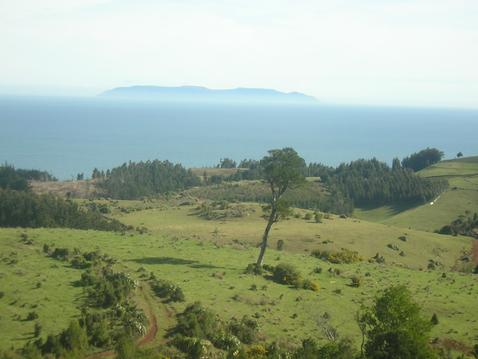
Mocha Island ( ) is a Chilean island located west of the coast of Arauco Province in the Pacific Ocean. The island is the location of numerous historic shipwrecks. In Mapuche mythology, the souls of dead people travel west to visit this island. The waters off the island are a popular place for recreational sea fishing.
History
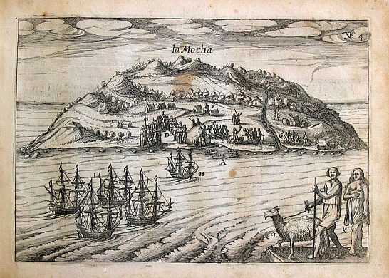
The island was historically inhabited by an indigenous coastal population of Mapuches known as the Lafkenches. The first European to document Mocha was Juan Bautista Pastene on September 10, 1544, who named it Isla de San Nicolas de Tolentino.
According to Juan Ignacio Molina, the Dutch captain Joris van Spilbergen observed the use of chilihueques (a South American camelid) by native Mapuches of Mocha Island as plough animals in 1614.
Mocha Island was regularly visited by pirates and privateers from the Netherlands and England. Francis Drake and Olivier van Noort are known to have used the island as a supply base. When Drake was visiting it during his circumnavigation of the globe he was seriously hurt by its Mapuche inhabitants. Richard Hawkins, Drake's cousin, also passed with his ship the Dainty. In 1685, the Mapuche were transported by Governor José de Garro to a reducción on the plain on the right bank of the Bio Bio River called the Valley of Mocha that later became the location of the modern city of Concepción, Chile.
The waters off the island were inhabited by sperm whale, including Mocha Dick, who was depicted by American explorer and author Jeremiah N. Reynolds in his published account, "Mocha Dick: Or The White Whale of the Pacific: A Leaf from a Manuscript Journal" in May, 1839 in The Knickerbocker magazine in New York. Mocha Dick was one of the inspirations for the fictional whale Moby Dick in the 1851 novel Moby-Dick by Herman Melville.
Polynesian contact
In December 2007 several human skulls with Polynesian features, such as a pentagonal shape when viewed from behind, were found lying on a shelf in a museum in Concepción. These skulls originated from Mocha Island.
Geography
The island is approximately 48 km2 in area, with a chain of mountains running north–south.
Geology
Geologically, the island is made of sedimentary rock stratum of Ranquil Formation, a formation whose main outcrops lie in the continent. The island was permanently uplifted as result of the 2010 Chile earthquake but this uplift was less than in the adjacent coast where Tirúa had the largest uplift of all the coast. The existence of a splay fault called Tirúa-Mocha Fault may explain the different behaviour of Mocha Island relative to the mainland during this earthquake.
Environment
Mocha Island National Reserve covers approximately 45% of the island's surface. The Pacific degu (Octodon pacificus), also known as the Mocha Island degu, a species of rodent in the family Octodontidae, is endemic to Mocha Island. The island has been designated an Important Bird Area (IBA) by BirdLife International because it supports significant populations of pink-footed shearwaters, Peruvian pelicans, red-legged cormorants and elegant terns.
Climate
| access-date = 27 May 2024 |archive-url = https://web.archive.org/web/20091122225453/http://www.ecolyma.cl/documentos/bioclimatografia_de_chile.pdf |archive-date = 22 November 2009
References
Sources
References
- ''The Geographical, Natural and Civil History of Chili'', [https://books.google.com/books?id=F4oIAAAAQAAJ Pages 15 and 16, Volume II]
- J. N. Reynolds. "[https://books.google.com/books?id=RBfZAAAAMAAJ&dq=the%20knickerbocker%20mocha%20dick&pg=PA377 Mocha Dick: or the White Whale of the Pacific: A Leaf from a Manuscript Journal]," ''The Knickerbocker, or New-York Monthly Magazine''. Vol. 13, No. 5, May 1839, pp. 377–392.
- [[Andrew Delbanco. Delbanco, Andrew]]. ''Melville, His World and Work''. New York: Alfred A. Knopf, 2005: 167–168. {{ISBN. 0-375-40314-0
- Lawler, Andrew. (2010-06-11). "Beyond ''Kon-Tiki'': Did Polynesians Sail to South America?". Science.
- García A., Floreal. (1968). "El Terciario de Chile Zona Central". Editorial Andrés Bello.
- (2020). "Unexpected coseismic surface uplift at Tirúa-Mocha Island area of south Chile before and during the Mw 8.8 Maule 2010 earthquake: a possible upper plate splay fault". [[National Geology and Mining Service]].
- . (2024). ["Isla Mocha"](https://datazone.birdlife.org/site/factsheet/24752). *BirdLife International*.
This article was imported from Wikipedia and is available under the Creative Commons Attribution-ShareAlike 4.0 License. Content has been adapted to SurfDoc format. Original contributors can be found on the article history page.
Ask Mako anything about Mocha Island — get instant answers, deeper analysis, and related topics.
Research with MakoFree with your Surf account
Create a free account to save articles, ask Mako questions, and organize your research.
Sign up freeThis content may have been generated or modified by AI. CloudSurf Software LLC is not responsible for the accuracy, completeness, or reliability of AI-generated content. Always verify important information from primary sources.
Report