From Surf Wiki (app.surf) — the open knowledge base
Miyako, Iwate

| Field | Value |
|---|---|
| name | Miyako |
| native_name | 宮古市 |
| native_name_lang | ja |
| settlement_type | City |
| image_skyline | {{multiple image |
| border | infobox |
| perrow | 1/3/2/2/1 |
| caption_align | center |
| total_width | 280 |
| caption1 | Earthquake Memorial Park |
| caption2 | Miyako downtown |
| caption3 | Miyako skyline |
| image_flag | Flag of Miyako Iwate.svg |
| image_seal | Emblem of Miyako, Iwate.svg |
| image_map | |
| image_map1 | Miyako in Iwate Prefecture Ja.svg |
| map_caption | Location of Miyako in Iwate Prefecture |
| pushpin_map | Japan |
| pushpin_label_position | |
| pushpin_map_caption | |
| coordinates | |
| coor_pinpoint | |
| coordinates_footnotes | tags -- |
| subdivision_type | Country |
| subdivision_name | Japan |
| subdivision_type1 | Region |
| subdivision_name1 | Tōhoku |
| subdivision_type2 | Prefecture |
| subdivision_name2 | Iwate |
| established_title | |
| seat_type | |
| government_footnotes | tags -- |
| leader_title | -Mayor |
| leader_name | Masanori Yamamoto (since 2009) |
| leader_name1 | |
| total_type | |
| unit_pref | |
| area_magnitude | |
| area_footnotes | tags -- |
| area_total_km2 | 1259.15 |
| elevation_footnotes | tags -- |
| population_footnotes | tags -- |
| population_total | 51150 |
| population_as_of | April 1, 2020 |
| population_density_km2 | auto |
| population_demonym | |
| timezone1 | Japan Standard Time |
| utc_offset1 | +09:00 |
| area_code_type | |
| blank_name_sec1 | City symbols |
| blank_info_sec1 | |
| blank1_name_sec1 | - Tree |
| blank1_info_sec1 | Japanese red pine |
| blank2_name_sec1 | - Flower |
| blank2_info_sec1 | Montauk daisy (Nipponanthemum nipponicum) |
| blank3_name_sec1 | - Bird |
| blank3_info_sec1 | Black-tailed gull |
| blank4_name_sec1 | - Insect |
| blank5_name_sec1 | - Fish |
| blank5_info_sec1 | Chum salmon |
| blank_name_sec2 | Phone number |
| blank_info_sec2 | 0193-62-2111 |
| blank1_name_sec2 | Address |
| blank1_info_sec2 | 2-1 Shinkawachō, Miyako-shi, Iwate-ken 027-8501 |
| website |
Earthquake Memorial Park Nakanohama.jpg Miyako downtown.jpg Miyako 20160505.jpg
Miyako is a city located in Iwate Prefecture, Japan. , the city had an estimated population of 51,150, and a population density of 41 persons per km2. The total area of the city is 1259.15 sqkm.
Geography
Miyako is located in central Iwate Prefecture, bordered by the Pacific Ocean to the east, with the main urban area fronting on Miyako Bay. It is located at the northern end of the rias coastal area of the Sanriku Coast, east of the prefectural capital of Morioka. The city area is the largest in Iwate Prefecture and the second largest in the Tōhoku region (after Tsuruoka, Yamagata). However, around 90% of the city area is covered by mountains and forest, so the habitable area is only about 9% of the total area, and therefore although the population density per total area is low, but the population density per habitable area exceeds the prefecture average. Miyako is connected to Morioka by an east–west train line and highway and the coastal highway also goes through the town. The city has a small port but much of the shipping traffic is taken by larger cities along the coast. Parts of the coastal area of the city are within the borders of the Sanriku Fukkō National Park, and part of the mountainous interior is within Hayachine Quasi-National Park. The easternmost point of Honshu island is at Cape Todo in Miyako.
Neighboring municipalities
Iwate Prefecture
- Hanamaki
- Iwaizumi
- Morioka
- Ōtsuchi
- Tōno
- Yamada
Climate
Miyako straddles between a warm-summer humid continental climate (Köppen climate classification Dfb) and a hot-summer humid continental climate (Dfa), characterized by warm summers and cold winters. The average annual temperature in Miyako is 10.9 °C. The average annual rainfall is 1282 mm with September as the wettest month and February as the driest month. The temperatures are highest on average in August, at around 22.1 °C, and lowest in January, at around 0.5 °C.
|Jan record high C = 18.9 |Feb record high C = 21.3 |Mar record high C = 24.2 |Apr record high C = 32.1 |May record high C = 32.9 |Jun record high C = 35.9 |Jul record high C = 37.4 |Aug record high C = 37.2 |Sep record high C = 34.6 |Oct record high C = 30.0 |Nov record high C = 26.9 |Dec record high C = 23.2 |Jan record low C = -17.3 |Feb record low C = -15.1 |Mar record low C = -14.6 |Apr record low C = -7.3 |May record low C = -1.5 |Jun record low C = 1.6 |Jul record low C = 4.9 |Aug record low C = 9.6 |Sep record low C = 3.7 |Oct record low C = -2.9 |Nov record low C = -7.0 |Dec record low C = -13.4 |script-title=ja:宮古 平年値(年・月ごとの値) 主な要素 | access-date = December 18, 2019 |script-title=ja:観測史上1~10位の値(年間を通じての値) | access-date = December 18, 2019
Demographics
Per Japanese census data, the population of Miyako peaked in around the year 1960 and has declined steadily over the past 60 years.
| 1920 | 44,635 | 1930 | 53,366 | 1940 | 70,318 | 1950 | 55,744 | 1960 | 81,093 | 1970 | 79,805 | 1980 | 78,617 | 1990 | 72,538 | 2000 | 66,986 | 2010 | 59,442 | 2020 | 50,369
History
The area of present-day Miyako was part of ancient Mutsu Province, and has been settled since at least the Jōmon period. The area was inhabited by the Emishi people, and came under the control of the imperial dynasty during the early Heian period with the construction a fortified settlement on the coast. During the Muromachi period, the area came under the control of the Nambu clan, and was the main seaport for Morioka Domain during the Edo period under the Tokugawa shogunate.
On 27 January 1700, the coast of Miyako was hit by a 3 m tsunami that was a product of the 1700 Cascadia earthquake, destroying 20 homes. The record from Miyako helped provide an exact date for the earthquake.
During the Boshin War of the Meiji restoration, the Battle of Miyako Bay was one of the major naval engagements of the war.
Under the Meiji period establishment of the modern municipalities system, the towns of Miyako and Kuwagasaki were established within Higashihei District. The area was devastated by a 18.9 m tsunami in 1896, which killed 1,859 inhabitants. Higashihei District became part of Shimohei District on 1 April 1897. Miyako and Kuwagasaki merged on 1 April 1924. On 3 March 1933, much of the town was destroyed by the 1933 Sanriku earthquake, which killed 911 people and destroyed over 98% of the buildings in the town. Miyako attained city status on 20 June 1940.
On 6 June 2005, Miyako absorbed the town of Tarō, and village of Niisato, more than doubling the old city's size. On 1 January 2010, Miyako absorbed the village of Kawai (also from Shimohei District).
2011 Tōhoku earthquake and tsunami

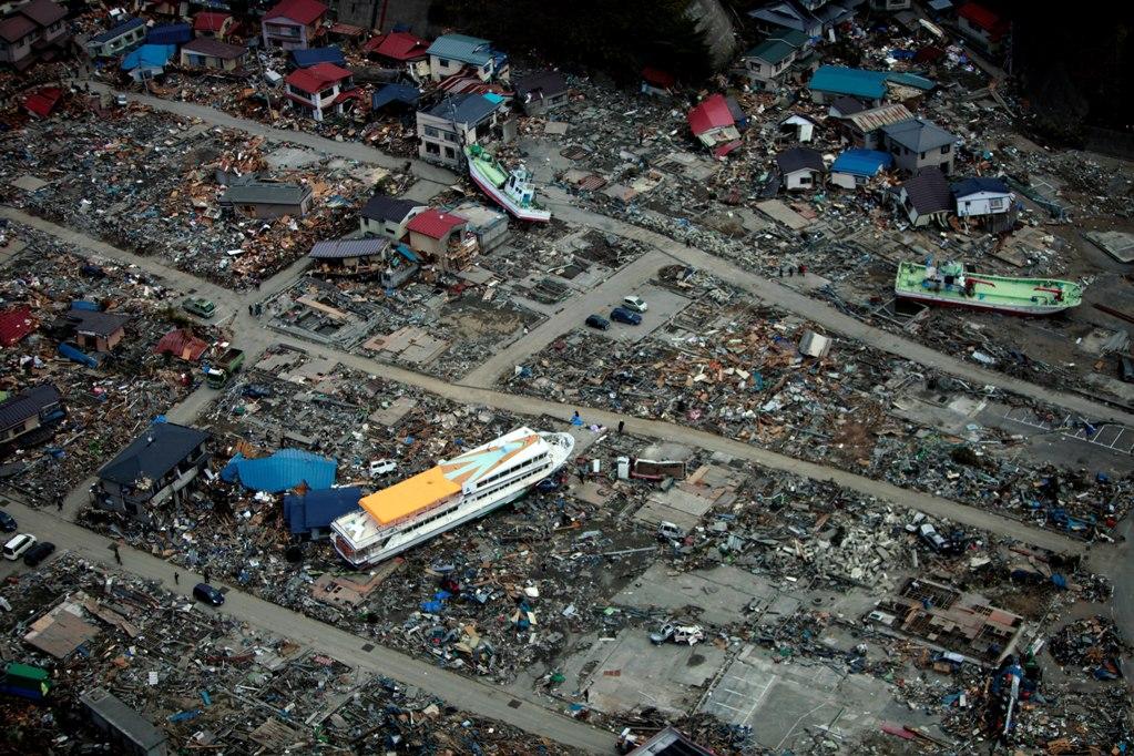
On 11 March 2011, Miyako was devastated by a tsunami caused by the 2011 Tōhoku earthquake. Only about 30–60 boats survived from the town's 960 ship fishing fleet. A subsequent field study by the University of Tokyo's Earthquake Research Institute revealed that the waters had reached at least 37.9 m above sea level, almost equaling the 38.2 m record of the tsunami created by the 1896 Sanriku earthquake. The final reported death toll from the disaster for the Miyako region was 420 confirmed dead, 92 missing, and 4,005 buildings destroyed.
Some of the most iconic footage of the tsunami, repeatedly broadcast worldwide, was shot in Miyako. It shows a dark black wave cresting and overflowing a floodwall and tossing cars, followed by a fishing ship capsizing as it hit the submerged floodwall and then crushed as it was forced beneath a bridge.
Government

Miyako has a mayor-council form of government with a directly elected mayor and a unicameral city legislature of 28 members. Miyako, together with the town of Iwaizumi and the villages of Fudai, Tanohata, and Yamada, collectively contributes three seats to the Iwate Prefectural legislature. In terms of national politics, the village is part of Iwate 2nd district of the lower house of the Diet of Japan.
Economy
The local economy of Miyako is based heavily on commercial fishing and food processing.
Education
Colleges
- Miyako Junior College
Primary and secondary education
- Miyako has 21 public elementary schools and 11 public junior high schools operated by the city government. The city has five public high schools operated by the Iwate Prefectural Board of Education and one private high school. Iwate Prefecture also operates one special education school for the handicapped.
Transportation
Railway
Sanriku Railway – Rias Line
Highway
Port
- Port of Miyako
Local attractions
- Cape Todo
- Jōdogahama, National Place of Scenic Beauty
- Mount Hayachine, one of the 100 Famous Japanese Mountains
- Sakiyama Shell Mound, a Jōmon-period National Historic Site
- Sanriku Fukkō National Park
International relations
- China Yantai, Shandong province, China, friendship city since April 1, 1966
- Philippines La Trinidad, Benguet, Philippines, friendship city since August 7, 1992
Noted people from Miyako
- Toshio Fujiwara, kick-boxer
- Nobutoshi Hikage, judoka
- Mirai Maiumi, professional wrestler
- Tokuichiro Tamazawa, politician
In popular media
- Miyako was a filming location for Times of Joy and Sorrow starring Hideko Takamine and Keiji Sada in 1957.
- Miyako was the hometown of the heroine from the 2022 anime film Suzume. A door similar to one featured in the film was set up as a pilgrimage destination for fans.
References
References
- "Minako City official statistics".
- [https://en.climate-data.org/location/5144/ Miyako climate data]
- [https://www.citypopulation.de/Japan-Iwate.html Miyako population statistics]
- (18 January 1996). "Time and size of a giant earthquake in Cascadia inferred from Japanese tsunami records of January 1700". Nature.
- [[Kyodo News]], "Deaths, people missing set to top 1,600: Edano", ''[[The Japan Times]]'', 13 March 2011.
- [[Agence France-Presse]]/[[Jiji Press]], "Fishermen who lost livelihoods determined to return to cruel sea", ''[[The Japan Times]]'', 4 April 2011, p. 2.
- Fukada, Takahiro, "[http://search.japantimes.co.jp/cgi-bin/nn20110921f1.html Iwate fisheries continue struggle to recover]", ''[[The Japan Times]]'', 21 September 2011, p. 3.
- [http://search.japantimes.co.jp/cgi-bin/nn20110404a6.html Iwate saw wave test 38 meters], ''[[The Japan Times]]'' ([[Kyodo News]]), 4 April 2011
- 岩手県発行 岩手県東日本大震災津波の記録 p43
- (2011-03-11). "東北・関東地震 宮古市の港に到達した津波". [[YouTube]].
- (October 2017}} At {{coord). "When Tsunami hit Miyako". Panoramio.
- "浄土ヶ浜". [[Agency for Cultural Affairs]].
- "崎山貝塚 さきやまかいづか". Agency for Cultural Affairs.
- "International Exchange". Council of Local Authorities for International Relations (CLAIR).
- (3 March 2023). "Doors inspired by smash hit film 'Suzume' appear along Japan's tsunami-hit Sanriku coast". [[Mainichi Shimbun]].
This article was imported from Wikipedia and is available under the Creative Commons Attribution-ShareAlike 4.0 License. Content has been adapted to SurfDoc format. Original contributors can be found on the article history page.
Ask Mako anything about Miyako, Iwate — get instant answers, deeper analysis, and related topics.
Research with MakoFree with your Surf account
Create a free account to save articles, ask Mako questions, and organize your research.
Sign up freeThis content may have been generated or modified by AI. CloudSurf Software LLC is not responsible for the accuracy, completeness, or reliability of AI-generated content. Always verify important information from primary sources.
Report