From Surf Wiki (app.surf) — the open knowledge base
Missouri River
Major river in central United States

Major river in central United States
| Field | Value | |
|---|---|---|
| name | Missouri River | |
| native_name | lkt | |
| name_other | Pekitanoui, Big Muddy, Mighty Mo, Wide Missouri, Kícpaarukstiʾ,{{cite web | |
| title | AISRI Dictionary Database Search—prototype version. "River", Southband Pawnee | |
| work | American Indian Studies Research Institute | |
| access-date | May 26, 2012 | |
| url | http://zia.aisri.indiana.edu/~dictsearch/cgi-bin/testengltoxsrchNP.pl?host=zia&pass=&hasfont=0&srchlang=English&srchstring=river&database=south&srchtype=AND&sortlang=English&sndformat=ra&maxhits=200&find=Run_Search | |
| archive-url | https://web.archive.org/web/20130117053713/http://zia.aisri.indiana.edu/~dictsearch/cgi-bin/testengltoxsrchNP.pl?host=zia&pass=&hasfont=0&srchlang=English&srchstring=river&database=south&srchtype=AND&sortlang=English&sndformat=ra&maxhits=200&find=Run_Search | |
| archive-date | January 17, 2013 | |
| url-status | dead | |
| }}</ref> Mnišoše<ref name | "Uniquely South Dakota"/ | |
| name_etymology | The Missouri tribe, whose name in turn meant "people with wooden canoes" | |
| <!---------------------- IMAGE & MAP --> | image | Missouri River in 2021 01.jpg |
| image_size | 300px | |
| image_caption | The Missouri River in Montana | |
| map | Missouri River basin map.png | |
| map_size | 350px | |
| map_caption | Map of the Missouri River and its tributaries in | |
| North America | ||
| pushpin_map_size | 350px | |
| pushpin_map_caption | ||
| subdivision_type1 | Country | |
| subdivision_name1 | United States | |
| subdivision_type2 | State | |
| subdivision_name2 | Montana, North Dakota, South Dakota, Nebraska, Iowa, Kansas, Missouri | |
| subdivision_type5 | Major cities | |
| subdivision_name5 | Great Falls, MT, Bismarck, ND, Pierre, SD, Sioux City, IA, Omaha, NE, Brownville, NE, Saint Joseph, MO, Kansas City, MO-KS | |
| <!---------------------- PHYSICAL CHARACTERISTICS --> | length | 2341 mi{{cite web |
| url | https://infolink.cr.usgs.gov/Science/MoREAP/moreap_brief.htm | |
| title | Missouri River Environmental Assessment Program Summary | |
| publisher | U.S. Geological Survey | |
| access-date | October 8, 2010 | |
| archive-url | https://web.archive.org/web/20100527125158/http://infolink.cr.usgs.gov/Science/MoREAP/moreap_brief.htm | |
| archive-date | May 27, 2010 | |
| url-status | dead | |
| df | mdy-all | |
| discharge1_location | Hermann, MO; RM 97.9 (RKM 157.6) | |
| discharge1_min | 602 cuft/s | |
| discharge1_avg | 87520 cuft/s | |
| discharge1_max | 750000 cuft/s | |
| <!---------------------- BASIN FEATURES --> | source1 | Brower's Spring |
| source1_location | near Brower's Spring | |
| source1_coordinates | ||
| source1_elevation | 9100 ft | |
| source1_length | 295 mi | |
| source2 | Firehole River–Madison River | |
| source2_location | Madison Lake, Yellowstone National Park, WY | |
| source2_coordinates | ||
| source2_elevation | 8215 ft | |
| source2_length | 183 mi | |
| source_confluence | Missouri Headwaters State Park | |
| source_confluence_location | Three Forks, MT | |
| source_confluence_coordinates | ||
| source_confluence_elevation | 4042 ft | |
| mouth | Mississippi River | |
| mouth_location | Spanish Lake, MO | |
| mouth_coordinates | ||
| mouth_elevation | 404 ft | |
| basin_size | 529350 sqmi | |
| tributaries_left | Jefferson, Dearborn, Sun, Marias, Milk, James, Big Sioux, Grand, Chariton | |
| tributaries_right | Madison, Gallatin, Yellowstone, Little Missouri, Cheyenne, Bad, White, Niobrara, Platte, Kansas, Osage, Gasconade | |
| extra | {{Designation list | |
| embed | yes | |
| designation1 | nwsr | |
| designation1_type | Wild, Scenic, Recreational | |
| mapframe | yes | |
| mapframe-wikidata | yes | |
| mapframe-zoom | 4 | |
| mapframe-height | 250 | |
| mapframe-stroke-width | 1.5 | |
| mapframe-frame-width | 300 |
| access-date = May 26, 2012 | archive-url = https://web.archive.org/web/20130117053713/http://zia.aisri.indiana.edu/~dictsearch/cgi-bin/testengltoxsrchNP.pl?host=zia&pass=&hasfont=0&srchlang=English&srchstring=river&database=south&srchtype=AND&sortlang=English&sndformat=ra&maxhits=200&find=Run_Search | archive-date = January 17, 2013 | url-status = dead North America |access-date = October 8, 2010 |archive-url = https://web.archive.org/web/20100527125158/http://infolink.cr.usgs.gov/Science/MoREAP/moreap_brief.htm |archive-date = May 27, 2010 |url-status = dead | mapframe-wikidata = yes | mapframe-zoom = 4 | mapframe-height = 250 | mapframe-stroke-width = 1.5 | mapframe-frame-width = 300
The Missouri River is a river in the Central and Mountain West regions of the United States. The nation's longest, it rises in the eastern Centennial Mountains of the Bitterroot Range of the Rocky Mountains of southwestern Montana, then flows east and south for 2341 mi before entering the Mississippi River north of St. Louis, Missouri. The river drains semi-arid watershed of more than 500,000 square miles (1,300,000 km2), which includes parts of ten U.S. states and two Canadian provinces. Although a tributary of the Mississippi, the Missouri River is slightly longer and carries a comparable volume of water, though a fellow tributary (Ohio River) carries more water. When combined with the lower Mississippi River, it forms the world's fourth-longest river system.
For over 12,000 years, people have depended on the Missouri River and its tributaries as a source of sustenance and transportation. More than ten major groups of Native Americans populated the watershed, with most leading a nomadic lifestyle and dependent on enormous bison herds that roamed through the Great Plains. The first Europeans encountered the river in the late seventeenth century, and the region passed through Spanish and French hands before becoming part of the United States through the Louisiana Purchase.
The Missouri River was one of the main routes for the westward expansion of the United States during the 19th century. The growth of the fur trade in the early 19th century laid much of the groundwork as trappers explored the region and blazed trails. Pioneers headed west en masse beginning in the 1830s, first by covered wagon, then by the growing numbers of steamboats that entered service on the river. Conflict between settlers and Native Americans in the watershed led to some of the most longstanding violence of the American Indian Wars.
During the 20th century, the Missouri River basin was extensively developed for irrigation, flood control, and the generation of hydroelectric power. Fifteen dams impound the main stem of the river, with hundreds more on tributaries. The Missouri River's reservoirs include the largest, second-largest, and fourth-largest artificial lakes in the United States by surface area: Lake Sakakawea, Lake Oahe, and Fort Peck Lake. Meanders have been cut off and the river channelized to improve navigation, reducing its length by almost 200 mi from pre-development times. Although the lower Missouri valley is now a populous and highly productive agricultural and industrial region, heavy development has taken its toll on wildlife and fish populations as well as water quality.
Course
From the Rocky Mountains, three streams rise to form the headwaters of the Missouri River:
- The longest source stream begins near Brower's Spring in southwest Montana, 9100 ft above sea level on the southeastern slopes of Mount Jefferson in the Centennial Mountains. From there it flows west then north; runs first in Hell Roaring Creek then west into the Red Rock; swings northeast to become the Beaverhead River; and finally joins with the Big Hole to form the Jefferson River.
- The Firehole River, which originates in northwest Wyoming at Yellowstone National Park's Madison Lake, joins with the Gibbon River to form the Madison River.
- The Gallatin River flows out of Gallatin Lake which is also in Yellowstone National Park.
The Missouri River officially starts at the confluence of the Jefferson and Madison in Missouri Headwaters State Park near Three Forks, Montana, and is joined by the Gallatin a mile (1.6 km) downstream. It then passes through Canyon Ferry Lake, a reservoir west of the Big Belt Mountains. Issuing from the mountains near Cascade, the river flows northeast to the city of Great Falls, where it drops over the Great Falls of the Missouri, a series of five substantial waterfalls. It then winds east through a scenic region of canyons and badlands known as the Missouri Breaks, receiving the Marias River from the west then widening into the Fort Peck Lake reservoir a few miles above the confluence with the Musselshell River. Farther on, the river passes through the Fort Peck Dam, and immediately downstream, the Milk River joins from the north.
Flowing eastward through the plains of eastern Montana, the Missouri receives the Poplar River from the north before crossing into North Dakota where the Yellowstone River, its greatest tributary by volume, joins from the southwest. At the confluence, the Yellowstone is actually the larger river.{{efn| The Missouri's flow at Culbertson, Montana, 25 mi above the confluence of the two rivers, is about 9820 cuft/s and the Yellowstone's discharge at Sidney, Montana, roughly the same distance upstream along that river, is about 12370 cuft/s. The Missouri then meanders east past Williston and into Lake Sakakawea, the reservoir formed by Garrison Dam. Below the dam the Missouri receives the Knife River from the west and flows south to Bismarck, the capital of North Dakota, where the Heart River joins from the west. It slows into the Lake Oahe reservoir just before the Cannonball River confluence. While it continues south, eventually reaching Oahe Dam in South Dakota, the Grand, Moreau and Cheyenne Rivers all join the Missouri from the west.
The Missouri makes a bend to the southeast as it winds through the Great Plains, receiving the Niobrara River and many smaller tributaries from the southwest. It then proceeds to form the boundary of South Dakota and Nebraska and is joined by the James River from the north. At Sioux City the Big Sioux River comes in from the north, after which the Missouri forms the Iowa–Nebraska boundary. It flows south to the city of Omaha where it receives its longest tributary, the Platte River, from the west. Downstream, it begins to define the border between the states of Nebraska and Missouri, then flows between the states of Missouri and Kansas. The Missouri swings east at Kansas City, where the Kansas River enters from the west, and so on into north-central Missouri. To the east of Kansas City, the Missouri receives, on the left side, the Grand River. It passes south of Columbia and receives the Osage and Gasconade Rivers from the south downstream of Jefferson City. The river then rounds the northern side of St. Louis to join the Mississippi River on the border between Missouri and Illinois.
Watershed
The Missouri River's drainage basin spans 529350 sqmi,{{cite web |access-date = April 10, 2010 |archive-url = https://web.archive.org/web/20100527124725/http://infolink.cr.usgs.gov/The_River/MORstory.htm |archive-date = May 27, 2010 |url-status = dead encompassing nearly one-sixth of the area of the United States{{cite web |access-date=May 10, 2010 |archive-url=https://web.archive.org/web/20120619033247/http://www.cerc.usgs.gov/ScienceTopics.aspx?ScienceTopicId=10 |archive-date=June 19, 2012 |url-status=live |access-date=May 10, 2010 |archive-url=https://web.archive.org/web/20120520211322/http://www.britannica.com/EBchecked/topic/418612/North-America |archive-date=May 20, 2012 |url-status=live The Mississippi River flows for approximately 1172 mi above St. Louis, which is just over half of the Missouri's length. and drains an area three times as large.{{efn| The Mississippi drains an area of 172200 mi2 above the confluence with the Missouri River. The Missouri accounts for 45 percent of the annual flow of the Mississippi past St. Louis, and as much as 70 percent in certain droughts.
In 1990, the Missouri River watershed was home to about 12 million people. |access-date=January 15, 2012 |archive-url=https://web.archive.org/web/20120516053439/http://digitalcommons.unl.edu/cgi/viewcontent.cgi?article=1070&context=usarmyceomaha |archive-date=May 16, 2012 |url-status=live |access-date=January 17, 2012 |archive-url=https://web.archive.org/web/20101211074753/http://americancity.org/magazine/article/wyoming-metropolis-crane/ |archive-date=December 11, 2010 making it the largest metropolitan area in the Missouri River basin. Other major population centers – mostly in the watershed's southeastern portion – include Omaha, Nebraska, north of the confluence of the Missouri and Platte Rivers; Kansas City, Missouri – Kansas City, Kansas, at the confluence of the Missouri with the Kansas River; and the St. Louis metropolitan area, south of the Missouri River just below the latter's mouth, on the Mississippi. In contrast, the northwestern part of the watershed is sparsely populated. However, many northwestern cities, such as Billings, Montana, are among the fastest growing in the Missouri basin.
With more than 170000 mi2 under the plow, the Missouri River watershed includes roughly one-fourth of all the agricultural land in the United States, providing more than a third of the country's wheat, flax, barley, and oats. However, only 11000 mi2 of farmland in the basin is irrigated. A further 281000 mi2 of the basin is devoted to the raising of livestock, mainly cattle. Forested areas of the watershed, mostly second-growth, total about 43700 mi2. Urban areas, on the other hand, comprise less than 13000 mi2 of land. Most built-up areas are along the main stem and a few major tributaries, including the Platte and Yellowstone Rivers.{{cite news |access-date=January 17, 2012 |archive-url=https://web.archive.org/web/20120119203941/http://www.21stcenturysciencetech.com/Articles_2011/MissouriRiverProject.pdf |archive-date=January 19, 2012 |url-status=live

Elevation in the watershed varies from just over 400 ft at the Missouri's mouth to the 14293 ft summit of Mount Lincoln in central Colorado.{{cite web |access-date=October 8, 2010 |url-status=dead |archive-url=https://web.archive.org/web/20111015012701/http://egsc.usgs.gov/isb/pubs/booklets/elvadist/elvadist.html |archive-date=October 15, 2011
The Missouri's drainage basin has highly variable weather and rainfall patterns, Overall, the watershed is defined by a continental climate with warm, wet summers and harsh, cold winters. Most of the watershed receives an average of 8 to of precipitation each year. However, the westernmost portions of the basin in the Rockies as well as southeastern regions in Missouri may receive as much as 40 in. The vast majority of precipitation occurs in summer in most of the lower and middle basin, although the upper basin is known for short-lived but intense summer thunderstorms such as the one which produced the 1972 Black Hills flood through Rapid City, South Dakota. |access-date=January 15, 2012 |archive-url=https://web.archive.org/web/20120602034847/http://pubs.usgs.gov/fs/fs-037-02/ |archive-date=June 2, 2012 |url-status=live Winter temperatures in the northern and western portions of the basin typically drop to −20 °F or lower every winter with extremes as low as −60 F, while summer highs occasionally exceed 100 °F in all areas except the higher elevations of Montana, Wyoming and Colorado. Extreme maxima — almost all prior to 1960 — have exceeded 115 °F in all US states in the basin.
As one of the continent's most significant river systems, |archive-url=https://wayback.archive-it.org/all/20080414101144/http://www.cec.org/naatlas/img/NA-Watersheds.gif |url-status=dead |archive-date=April 14, 2008 |access-date=September 12, 2008 the Missouri's drainage basin borders on many other major watersheds of the United States and Canada. The Continental Divide, running along the spine of the Rocky Mountains, forms most of the western border of the Missouri watershed. The Clark Fork and Snake River, both part of the Columbia River basin, drain the area west of the Rockies in Montana, Idaho and western Wyoming. The Columbia, Missouri and Colorado River watersheds meet at Three Waters Mountain in Wyoming's Wind River Range. |access-date=January 14, 2012 |url-status=dead |archive-url=https://web.archive.org/web/20080513163803/http://nationalatlas.gov/articles/geology/a_continentalDiv.html |archive-date=May 13, 2008 South of there, the Missouri basin is bordered on the west by the drainage of the Green River, a tributary of the Colorado, then on the south by the mainstem of the Colorado. Both the Colorado and Columbia Rivers flow to the Pacific Ocean. However, a large endorheic drainage called the Great Divide Basin exists between the Missouri and Green watersheds in western Wyoming. This area is sometimes counted as part of the Missouri River watershed, even though its waters do not flow to either side of the Continental Divide.
To the north, the much lower Laurentian Divide separates the Missouri River watershed from those of the Oldman River, a tributary of the South Saskatchewan River, as well as the Souris, Sheyenne, and smaller tributaries of the Red River of the North. All of these streams are part of Canada's Nelson River drainage basin, which empties into Hudson Bay. There are also several large endorheic basins between the Missouri and Nelson watersheds in southern Alberta and Saskatchewan. The Minnesota and Des Moines Rivers, tributaries of the upper Mississippi, drain most of the area bordering the eastern side of the Missouri River basin. Finally, on the south, the Ozark Mountains and other low divides through central Missouri, Kansas and Colorado separate the Missouri watershed from those of the White River and Arkansas River, also tributaries of the Mississippi River.
Major tributaries

Main article: List of tributaries of the Missouri River
Over 95 significant tributaries and hundreds of smaller ones feed the Missouri River, with most of the larger ones coming in as the river draws close to the mouth.{{cite web |access-date=July 10, 2011 |archive-url=https://web.archive.org/web/20130523094749/http://www3.northern.edu/natsource/HABITATS/Missio1.htm |archive-date=May 23, 2013 |url-status=dead
The Missouri's largest tributaries by runoff are the Yellowstone in Montana and Wyoming, the Platte in Wyoming, Colorado, and Nebraska, and the Kansas–Republican/Smoky Hill and Osage in Kansas and Missouri. Each of these tributaries drains an area greater than 50000 mi2 or has an average discharge greater than 5000 cuft/s. The Yellowstone River has the highest discharge, even though the Platte is longer and drains a larger area. In fact, the Yellowstone's flow is about 13800 cuft/s |access-date = May 10, 2010 |url-status = dead |archive-url = https://web.archive.org/web/20051231072634/http://www.sage.wisc.edu/riverdata/scripts/station_table.php?qual=32&filenum=2845 |archive-date = December 31, 2005 – accounting for sixteen percent of total runoff in the Missouri basin and nearly double that of the Platte. On the other end of the scale is the tiny Roe River in Montana, which at 201 ft long is one of the world's shortest rivers.
| Longest tributaries of the Missouri River | mi | km | mi2 | km2 | ft3/s | m3/s | Platte River | Kansas River | Milk River | James River | Yellowstone River | White River | Niobrara River | Little Missouri River | Osage River | Big Sioux River |
|---|---|---|---|---|---|---|---|---|---|---|---|---|---|---|---|---|
| Name | Length | Watershed | Discharge | |||||||||||||
| 1,708 | 199 | |||||||||||||||
| 1,205 | 209 | |||||||||||||||
| 1,170 | 17.5 | |||||||||||||||
| 1,140 | 18.3 | |||||||||||||||
| 1,130 | 391 | |||||||||||||||
| 933 | 16.1 | |||||||||||||||
| 914 | 48.7 | |||||||||||||||
| 900 | 15.1 | |||||||||||||||
| 793 | 339 | |||||||||||||||
| 674 | 37.4 |
The table on the right lists the ten longest tributaries of the Missouri, along with their respective catchment areas and flows. Length is measured to the hydrologic source, regardless of naming convention. The main stem of the Kansas River, for example, is 148 mi long. However, including the longest headwaters tributaries, the 453 mi Republican River and the 156 mi Arikaree River, brings the total length to 749 mi. Similar naming issues are encountered with the Platte River, whose longest tributary, the North Platte River, is more than twice as long as its mainstream.
The Missouri's headwaters above Three Forks extend much farther upstream than the main stem. Measured to the farthest source at Brower's Spring, the Jefferson River is 298 mi long. Thus measured to its highest headwaters, the Missouri River stretches for 2639 mi. When combined with the lower Mississippi, the Missouri and its headwaters form part of the fourth-longest river system in the world, at 3745 mi. |access-date=January 14, 2012 |url-status=live |archive-url=https://web.archive.org/web/20120118010715/http://fwp.mt.gov/mtoutdoors/HTML/articles/2005/MissouriSource.htm |archive-date=January 18, 2012
Discharge

By discharge, the Missouri is the ninth largest river of the United States, after the Mississippi, St. Lawrence, Ohio, Columbia, Niagara, Yukon, Detroit, and St. Clair. The latter two, however, are sometimes considered part of a strait between Lake Huron and Lake Erie. |access-date=October 1, 2010 |archive-url=https://web.archive.org/web/20170129040848/https://pubs.usgs.gov/of/1987/ofr87-242/ |archive-date=January 29, 2017 |url-status=live Among rivers of North America as a whole, the Missouri is thirteenth largest, after the Mississippi, Mackenzie, St. Lawrence, Ohio, Columbia, Niagara, Yukon, Detroit, St. Clair, Fraser, Slave, and Koksoak. |access-date=November 28, 2010 |url-status=dead |archive-url=https://web.archive.org/web/20070410230512/http://atlas.nrcan.gc.ca/site/english/learningresources/facts/lakes.html |archive-date=April 10, 2007
As the Missouri drains a predominantly semi-arid region, its discharge is much lower and more variable than other North American rivers of comparable length. Before the construction of dams, the river flooded twice each year – once in the "April Rise" or "Spring Fresh", with the melting of snow on the plains of the watershed, and in the "June Rise", caused by snowmelt and summer rainstorms in the Rocky Mountains. The latter was far more destructive, with the river increasing to over ten times its normal discharge in some years.{{cite news |access-date=January 14, 2012 |archive-url=https://web.archive.org/web/20110612030152/http://www.bismarcktribune.com/news/columnists/article_ede94e28-8df1-11e0-a6bc-001cc4c002e0.html |archive-date=June 12, 2011 |url-status=live |access-date = January 14, 2012 |url-status = dead |archive-url = https://web.archive.org/web/20120513201159/http://dnr.mo.gov/pubs/pub2018.pdf |archive-date = May 13, 2012 The Missouri's discharge is affected by over 17,000 reservoirs with an aggregate capacity of some 141 e6acre-ft. By providing flood control, the reservoirs dramatically reduce peak flows and increase low flows. Evaporation from reservoirs significantly reduces the river's runoff, causing an annual loss of over 3 e6acre-ft from mainstem reservoirs alone.
| Monthly discharge at | |||
|---|---|---|---|
| Hermann, MO | Month | cfs | m3/s |
| Jan. | 52,400 | 1,490 | |
| Feb. | 67,900 | 1,920 | |
| Mar. | 96,300 | 2,730 | |
| Apr. | 119,000 | 3,370 | |
| May | 125,000 | 3,540 | |
| Jun. | 124,000 | 3,510 | |
| Jul. | 101,000 | 2,860 | |
| Aug. | 73,600 | 2,080 | |
| Sep. | 75,400 | 2,140 | |
| Oct. | 76,500 | 2,170 | |
| Nov. | 76,000 | 2,150 | |
| Dec. | 61,000 | 1,730 |
| Average discharge at | |||
|---|---|---|---|
| selected cities | |||
| City | cfs | m3/s | |
| Great Falls, MT | 10,300 | 292 | |
| Pierre, SD | 26,500 | 750 | |
| Sioux City, IA | 28,670 | 812 | |
| Omaha, NE | 32,190 | 912 | |
| Kansas City, MO | 55,400 | 1,570 | |
| Boonville, MO | 67,160 | 1,902 | |
| Hermann, MO | 87,520 | 2,478 |
|}
The United States Geological Survey operates fifty-one stream gauges along the Missouri River. The river's average discharge at Bismarck, 1314.5 mi from the mouth, is 21920 cuft/s. This is from a drainage area of 186400 mi2, or 35% of the total river basin. |access-date=January 9, 2012 |archive-url=https://web.archive.org/web/20111025012108/http://wdr.water.usgs.gov/wy2010/pdfs/06342500.2010.pdf |archive-date=October 25, 2011 |url-status=live |access-date=January 9, 2012 |archive-url=https://web.archive.org/web/20111023221230/http://wdr.water.usgs.gov/wy2010/pdfs/06893000.2010.pdf |archive-date=October 23, 2011 |url-status=live
The lowermost gage with a period of record greater than fifty years is at Hermann, Missouri – 97.9 mi upstream of the mouth of the Missouri – where the average annual flow was 87520 cuft/s from 1897 to 2010. About 522500 mi2, or 98.7% of the watershed, lies above Hermann. The highest annual mean was 181800 cuft/s in 1993, and the lowest was 41690 cuft/s in 2006. Extremes of the flow vary even further. The largest discharge ever recorded was over 750000 cuft/s on July 31, 1993, during a historic flood. The lowest, a mere 602 cuft/s – caused by the formation of an ice dam – was measured on December 23, 1963.
Geology

The Rocky Mountains of southwestern Montana at the headwaters of the Missouri River first rose in the Laramide Orogeny, a mountain-building episode that occurred from around 70 to 45 million years ago (the end of the Mesozoic through the early Cenozoic). This orogeny uplifted Cretaceous rocks along the western side of the Western Interior Seaway, a vast shallow sea that stretched from the Arctic Ocean to the Gulf of Mexico, and deposited the sediments that now underlie much of the drainage basin of the Missouri River. |access-date = October 1, 2010 |archive-url = https://web.archive.org/web/20100820080046/http://jan.ucc.nau.edu/~rcb7/crepaleo.html |archive-date = August 20, 2010 |url-status = dead This Laramide uplift caused the sea to retreat and laid the framework for a vast drainage system of rivers flowing from the Rocky and Appalachian Mountains, the predecessor of the modern-day Mississippi watershed. The Laramide Orogeny is essential to modern Missouri River hydrology, as snow and ice melt from the Rockies provide the majority of the flow in the Missouri and its tributaries.
The Missouri and many of its tributaries cross the Great Plains, flowing over or cutting into the Ogallala Group and older mid-Cenozoic sedimentary rocks. The lowest major Cenozoic unit, the White River Formation, was deposited between roughly 35 and 29 million years ago |doi-access=free these formations stretch from the Rocky Mountains nearly to the Iowa border and give the Great Plains much of their gentle but persistent eastward tilt, and also constitute a major aquifer.
Immediately before the Quaternary Ice Age, the Missouri River was likely split into three segments: an upper portion that drained northwards into Hudson Bay,{{cite report |access-date=October 1, 2010 |archive-url=https://web.archive.org/web/20120415090611/http://maps.unomaha.edu/maher/2003mbfieldtrip/moakreport/pleistgeo.html |archive-date=April 15, 2012 |url-status=dead |access-date=October 12, 2010 |archive-url=https://web.archive.org/web/20130523094749/http://www3.northern.edu/natsource/HABITATS/Missio1.htm |archive-date=May 23, 2013 |url-status=dead and middle and lower sections that flowed eastward down the regional slope. As the Earth plunged into the Ice Age, a pre-Illinoian (or possibly the Illinoian) glaciation diverted the Missouri River southeastward toward its present confluence with the Mississippi and caused it to integrate into a single river system that cuts across the regional slope. In western Montana, the Missouri River is thought to have once flowed north then east around the Bear Paw Mountains. Sapphires are found in some spots along the river in western Montana. Advances of the continental ice sheets diverted the river and its tributaries, causing them to pool up into large temporary lakes such as Glacial Lakes Great Falls, Musselshell and others. As the lakes rose, the water in them often spilled across adjacent local drainage divides, creating now-abandoned channels and coulees including the Shonkin Sag, 100 mi long. When the glaciers retreated, the Missouri flowed in a new course along the south side of the Bearpaws, and the lower part of the Milk River tributary took over the original main channel. |access-date=June 28, 2011 |archive-url=https://web.archive.org/web/20120415090611/http://maps.unomaha.edu/maher/2003mbfieldtrip/moakreport/pleistgeo.html |archive-date=April 15, 2012 |url-status=dead
The Missouri's nickname, the "Big Muddy", was inspired by its enormous loads of sediment or silt – some of the largest of any North American river. In its pre-development state, the river transported some 175 to per year.{{cite web |access-date=October 6, 2010 |archive-url=https://web.archive.org/web/20120407071907/http://www.mostreamteam.org/Documents/Research/BigRiver/MissouriRiverSediment.pdf |archive-date=April 7, 2012 |url-status=live |access-date=October 7, 2010 |archive-url=https://web.archive.org/web/20120602143710/http://dels.nas.edu/Report/Missouri-River-Planning-Recognizing-Incorporating/13019 |archive-date=June 2, 2012 |url-status=live |access-date=October 6, 2010 |archive-url=https://web.archive.org/web/20101002013903/http://www.nola.com/politics/index.ssf/2010/09/missouri_river_helped_build_lo.html |archive-date=October 2, 2010 |url-status=dead
First people
Archaeological evidence, especially in Missouri, suggests that human beings first inhabited the watershed of the Missouri River between 10,000 and 12,000 years ago at the end of the Pleistocene.{{cite book |section-url=https://www.nps.gov/history/seac/benning-book/ch01.htm |access-date=October 4, 2010 |archive-url=https://web.archive.org/web/20120113133424/http://www.nps.gov/history/seac/benning-book/ch01.htm |archive-date=January 13, 2012 |url-status=usurped

Indigenous peoples of North America who have lived along the Missouri have historically had access to ample food, water, and shelter. Many migratory animals naturally inhabit the plains area. Before they were hunted by colonists and Native Americans, these animals, such as the buffalo, provided meat, clothing, and other everyday items; there were also great riparian areas in the river's floodplain that provided habitat for herbs and other staple foods.{{cite web |access-date=October 4, 2010 |archive-url=https://web.archive.org/web/20101129154030/http://www.nps.gov/history/seac/benning-book/ch02.htm |archive-date=November 29, 2010 |url-status=live
In this pre-colonial and early-colonial era, the Missouri river was used as a path of trade and transport, and the river and its tributaries often formed territorial boundaries. Most of the Indigenous peoples in the region at that time had semi-nomadic cultures, with many tribes maintaining different summer and winter camps. However, the center of Native American wealth and trade lay along the Missouri River in the Dakotas region on its great bend south. |access-date = October 5, 2010 |archive-url = https://web.archive.org/web/20110218014336/http://www.nationalgeographic.com/lewisandclark/record_tribes_010_5_3.html |archive-date = February 18, 2011 |url-status = dead A large cluster of walled Mandan, Hidatsa and Arikara villages situated on bluffs and islands of the river was home to thousands, and later served as a market and trading post used by early French and British explorers and fur traders. |archive-url=https://web.archive.org/web/20101129154050/http://www.nps.gov/archive/knri/overview.htm |archive-date=November 29, 2010 |access-date=October 5, 2010 Following the introduction of horses to Missouri River tribes, possibly from feral European-introduced populations, Natives' way of life changed dramatically. The use of the horse allowed them to travel greater distances, and thus facilitated hunting, communications, warfare, the Siouxoan genocide and expulsion of many tribes, and the abundance of trade.
Once, tens of millions of American bison (commonly called buffalo), one of the keystone species of the Great Plains and the Ohio Valley, roamed the plains of the Missouri River basin. Most Native American nations in the basin relied heavily on the bison as a food source, and their hides and bones served to create other household items. In time, the species came to benefit from the indigenous peoples' periodic controlled burnings of the grasslands surrounding the Missouri to clear out old and dead growth. The large bison population of the region gave rise to the term great bison belt, an area of rich annual grasslands that extended from Alaska to Mexico along the eastern flank of the Continental Divide. However, after the arrival of Europeans in North America, both the bison and the Native Americans saw a rapid decline in population. |access-date=October 4, 2010 |archive-url=https://web.archive.org/web/20100926033809/http://www.pbs.org/wnet/nature/episodes/american-buffalo-spirit-of-a-nation/introduction/2183/ |archive-date=September 26, 2010 |url-status=live Massive over-hunting for sport by colonists eliminated bison populations east of the Mississippi River by 1833 and reduced the numbers in the Missouri basin to a mere few hundred. Foreign diseases brought by settlers, such as smallpox, raged across the land, decimating Native American populations. Left without their primary source of sustenance, many of the remaining indigenous people were forced onto resettlement areas and reservations, often at gunpoint.
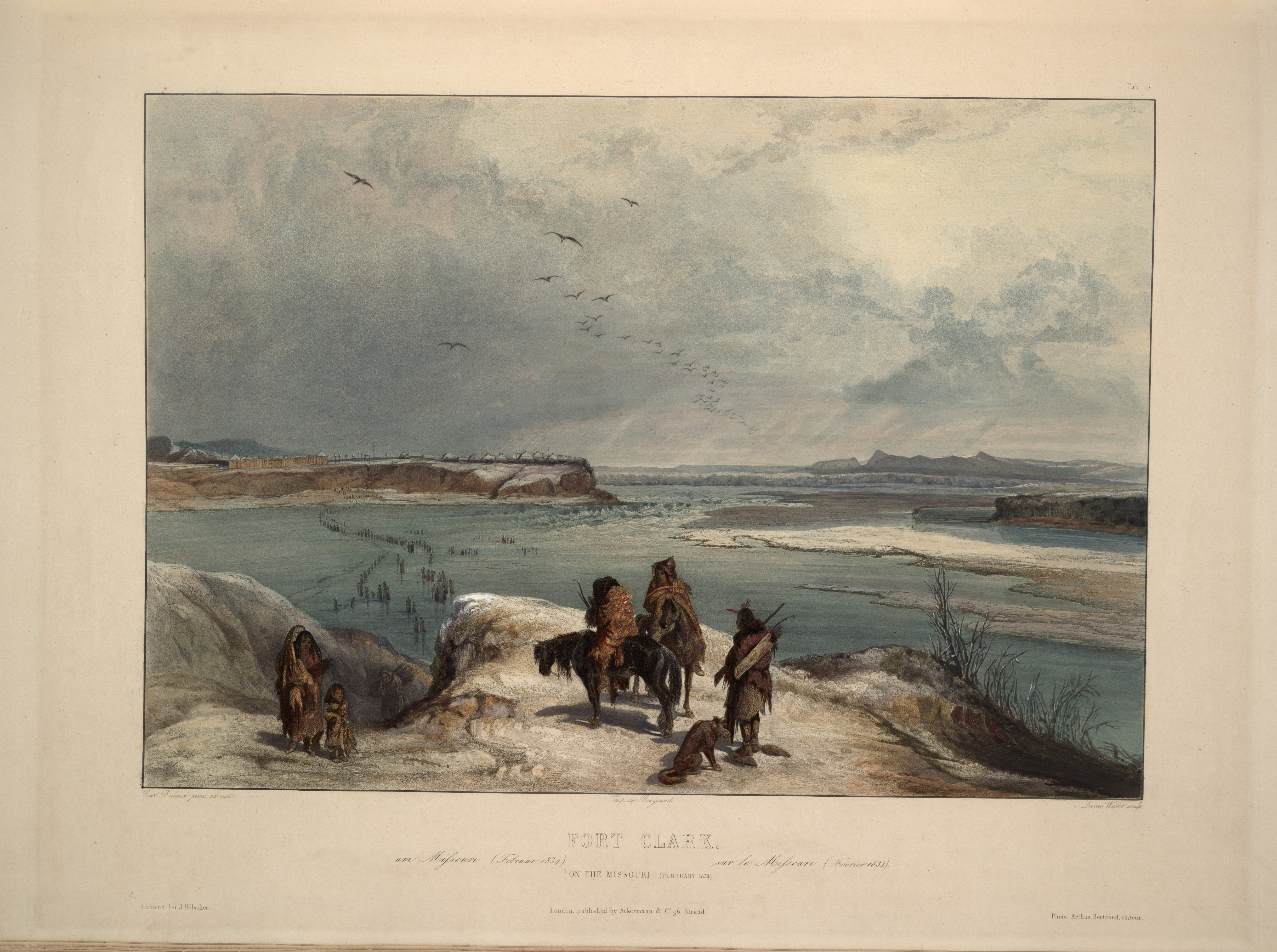
Early European explorers

In May 1673, the French-Canadian explorer Louis Jolliet and the French explorer Jacques Marquette left the settlement of St. Ignace on Lake Huron and traveled down the Wisconsin and Mississippi Rivers, aiming to reach the Pacific Ocean. In late June, Jolliet and Marquette became the first documented European discoverers of the Missouri River, which according to their journals was in full flood. |access-date=November 19, 2010 |archive-url=https://web.archive.org/web/20120129090217/http://www.wisconsinhistory.org/diary/001412.asp |archive-date=January 29, 2012 |url-status=live "I never saw anything more terrific," Jolliet wrote, "a tangle of entire trees from the mouth of the Pekistanoui [Missouri] with such impetuosity that one could not attempt to cross it without great danger. The commotion was such that the water was made muddy by it and could not clear itself." They recorded Pekitanoui or Pekistanoui as the local name for the Missouri. However, the party never explored the Missouri beyond its mouth, nor did they linger in the area. In addition, they later learned that the Mississippi drained into the Gulf of Mexico and not the Pacific as they had originally presumed; the expedition turned back about 440 mi short of the Gulf at the confluence of the Arkansas River with the Mississippi.
In 1682, France expanded its territorial claims in North America to include land on the western side of the Mississippi River, which included the lower portion of the Missouri. However, the Missouri itself remained formally unexplored until Étienne de Veniard, Sieur de Bourgmont commanded an expedition in 1714 that reached at least as far as the mouth of the Platte River. It is unclear exactly how far Bourgmont traveled beyond there; he described the blond-haired Mandans in his journals, so it is likely he reached as far as their villages in present-day North Dakota. Later that year, Bourgmont published The Route To Be Taken To Ascend The Missouri River, the first known document to use the name "Missouri River"; many of the names he gave to tributaries, mostly from the native tribes that lived along them, are still in use today. The expedition's discoveries eventually found their way to cartographer Guillaume Delisle, who used the information to create a map of the lower Missouri. |access-date=January 7, 2011 |url-status=live |archive-url=https://web.archive.org/web/20120113120132/http://www.nps.gov/jeff/historyculture/loader.cfm?csModule=security%2Fgetfile&pageid=145929 |archive-date=January 13, 2012 In 1718, Jean-Baptiste Le Moyne, Sieur de Bienville requested that the French government bestow upon Bourgmont the Cross of St. Louis because of his "outstanding service to France".
Bourgmont had in fact been in trouble with the French colonial authorities since 1706, when he deserted his post as commandant of Fort Detroit after poorly handling an attack by the Ottawa that resulted in thirty-one deaths. |access-date = October 4, 2010 |url-status = dead |archive-url = https://archive.today/20130121114819/http://apps.detnews.com/apps/history/index.php?id=180 |archive-date = January 21, 2013 However, his reputation was enhanced in 1720 when the Pawnee – who had earlier been befriended by Bourgmont – massacred the Spanish Villasur expedition near present-day Columbus, Nebraska, on the Missouri River, temporarily ending Spanish encroachment on French Louisiana. |access-date=January 19, 2012 |url-status=usurped |archive-url=https://web.archive.org/web/20080210060051/http://www.nebraskahistory.org/publish/markers/texts/villasur_expedition_1720.htm |archive-date=February 10, 2008
Bourgmont established Fort Orleans, the first European settlement of any kind on the Missouri River, near present-day Brunswick, Missouri, in 1723. The following year Bourgmont led an expedition to enlist Comanche support against the Spanish, who continued to show interest in taking over the Missouri. In 1725 Bourgmont brought the chiefs of several Missouri River tribes to visit France. There he was raised to the rank of nobility and did not accompany the chiefs back to North America. Fort Orleans was either abandoned or its small contingent massacred by Native Americans in 1726.
The French and Indian War erupted when territorial disputes between France and Great Britain in North America reached a head in 1754. By 1763, France's army in North America had been defeated by a combined British-American force and was forced to sue for peace. In the Treaty of Paris, France ceded its Canadian possessions to the British, gaining Louisiana from the Spanish in return. |access-date= October 5, 2010 |url-status=live |archive-url= https://web.archive.org/web/20110220234807/http://avalon.law.yale.edu/18th_century/paris763.asp |archive-date= February 20, 2011 Initially, the Spanish did not extensively explore the Missouri and let French traders continue their activities under license. However, this ended after news of incursions by trappers working for the Hudson's Bay Company in the upper Missouri River watershed was brought back following an expedition by Jacques D'Eglise in the early 1790s. In 1795 the Spanish chartered the Company of Discoverers and Explorers of the Missouri, popularly referred to as the "Missouri Company", and offered a reward for the first person to reach the Pacific Ocean via the Missouri. In 1794 and 1795 expeditions led by Jean-Baptiste Truteau and Antoine Simon Lecuyer de la Jonchšre did not even make it as far north as the Mandan villages in central North Dakota.
Arguably the most successful of the Missouri Company expeditions was that of James MacKay and John Evans. |access-date=January 23, 2012 |url-status=live |archive-url=https://web.archive.org/web/20120624030404/http://www.museum.state.il.us/exhibits/lewis_clark_il/htmls/il_country_exp/preps/mackay_evans_map.html |archive-date=June 24, 2012 The two set out along the Missouri, and established Fort Charles about 20 mi south of present-day Sioux City as a winter camp in 1795. At the Mandan villages in North Dakota, they forcefully expelled several British traders, and while talking to the populace they pinpointed the location of the Yellowstone River, which was called Roche Jaune ("Yellow Rock") by the French. Although MacKay and Evans failed to accomplish their original goal of reaching the Pacific, they did create the first accurate map of the upper Missouri River. |url-status=live |access-date=October 5, 2010 |archive-url=https://web.archive.org/web/20120516055448/http://digitalcommons.unl.edu/cgi/viewcontent.cgi?article=1132&context=greatplainsquarterly |archive-date=May 16, 2012
In 1795, the young United States and Spain signed Pinckney's Treaty, which recognized American rights to navigate the Mississippi River and store goods for export in New Orleans. Three years later, Spain revoked the treaty and in 1800 secretly returned Louisiana to Napoleonic France in the Third Treaty of San Ildefonso. This transfer was so secret that the Spanish continued to administer the territory. In 1801, Spain restored rights to use the Mississippi and New Orleans to the United States. |url-status=live |access-date=October 4, 2010 |archive-url=https://web.archive.org/web/20110608131332/http://www.napoleon-series.org/research/government/diplomatic/c_ildefonso.html |archive-date=June 8, 2011

Fearing that the cutoffs could occur again, President Thomas Jefferson proposed to buy the port of New Orleans from France for $10 million. Instead, faced with a debt crisis, Napoleon offered to sell the entirety of Louisiana, including the Missouri River, for $15 million – amounting to less than 3¢ per acre. The deal was signed in 1803, doubling the size of the United States with the acquisition of the Louisiana Territory. |access-date=October 4, 2010 |archive-url=https://web.archive.org/web/20101129154059/http://www.nps.gov/archive/jeff/lewisclark2/circa1804/heritage/louisianapurchase/louisianapurchase.htm |archive-date=November 29, 2010 In 1803, Jefferson instructed Meriwether Lewis to explore the Missouri and search for a water route to the Pacific Ocean. By then, it had been discovered that the Columbia River system, which drains into the Pacific, had a similar latitude as the headwaters of the Missouri River, and it was widely believed that a connection or short portage existed between the two. |orig-date = June 20, 1803 |date = June 24, 2003 |access-date = June 30, 2006 |url-status = live |archive-url = https://web.archive.org/web/20060701132502/http://www.loc.gov/exhibits/lewisandclark/lewis-landc.html#57 |archive-date = July 1, 2006 However, Spain balked at the takeover, citing that they had never formally returned Louisiana to the French. Spanish authorities warned Lewis not to take the journey and forbade him from seeing the MacKay and Evans map of the Missouri, although Lewis eventually managed to gain access to it. |access-date=January 6, 2011 |archive-url=https://web.archive.org/web/20120624030404/http://www.museum.state.il.us/exhibits/lewis_clark_il/htmls/il_country_exp/preps/mackay_evans_map.html |archive-date=June 24, 2012 |url-status=live |access-date=January 6, 2011 |archive-url=https://web.archive.org/web/20111003145759/http://www2.lib.virginia.edu/exhibits/lewis_clark/exploring/ch4.html |archive-date=October 3, 2011 |url-status=live
Meriwether Lewis and William Clark began their famed expedition in 1804 with a party of thirty-three people in three boats.{{cite web |access-date = October 5, 2010 |archive-url = https://web.archive.org/web/20110217232602/http://www.nationalgeographic.com/lewisandclark/journey_leg_1.html |archive-date = February 17, 2011 |url-status = dead |access-date=October 5, 2010 |archive-url=https://web.archive.org/web/20120410030735/http://www.nps.gov/nr/travel/lewisandclark/intro.htm |archive-date=April 10, 2012 |url-status=dead
American frontier
Fur trade

As early as the 18th century, fur trappers entered the extreme northern basin of the Missouri River in the hopes of finding populations of beaver and river otter, the sale of whose pelts drove the thriving North American fur trade. They came from many different places – some from the Canadian fur corporations at Hudson Bay, some from the Pacific Northwest (see also: Maritime fur trade), and some from the midwestern United States. Most did not stay in the area for long, as they failed to find significant resources. |access-date=October 18, 2010 |archive-url=https://web.archive.org/web/20120512004804/http://lewis-clark.org/content/content-article.asp?ArticleID=2970 |archive-date=May 12, 2012 |url-status=dead
The first glowing reports of country rich with thousands of game animals came in 1806 when Meriwether Lewis and William Clark returned from their two-year expedition. Their journals described lands amply stocked with thousands of buffalo, beaver, and river otter; and also an abundant population of sea otters on the Pacific Northwest coast. In 1807, explorer Manuel Lisa organized an expedition which would lead to the explosive growth of the fur trade in the upper Missouri River country. Lisa and his crew traveled up the Missouri and Yellowstone Rivers, trading manufactured items in return for furs from local Native American tribes, and established a fort at the confluence of the Yellowstone and a tributary, the Bighorn, in southern Montana. Although the business started small, it quickly grew into a thriving trade. |access-date=October 18, 2010 |archive-url=https://web.archive.org/web/20100308043436/http://www.history.com/this-day-in-history/fur-trader-manuel-lisa-dies |archive-date=March 8, 2010 |url-status=dead |access-date=October 19, 2010 |archive-url=https://web.archive.org/web/20101124211252/http://lewis-clark.org/content/content-article.asp?ArticleID=2868 |archive-date=November 24, 2010 |url-status=live
Lisa's men started construction of Fort Raymond, which sat on a bluff overlooking the confluence of the Yellowstone and Bighorn, in the fall of 1807. The fort would serve primarily as a trading post for bartering with the Native Americans for furs. This method was unlike that of the Pacific Northwest fur trade, which involved trappers hired by the various fur enterprises, namely Hudson's Bay. Fort Raymond was later replaced by Fort Lisa at the confluence of the Missouri and Yellowstone in North Dakota; a second fort also called Fort Lisa was built downstream on the Missouri River in Nebraska. In 1809 the St. Louis Missouri Fur Company was founded by Lisa in conjunction with William Clark and Pierre Choteau, among others. |access-date=October 19, 2010 |archive-url=https://web.archive.org/web/20120415095319/http://www.nps.gov/history/nr/travel/pierre_fortpierre/early_exploration_fur_trade_essay.html |archive-date=April 15, 2012 |url-status=dead In 1828, the American Fur Company founded Fort Union at the confluence of the Missouri and Yellowstone Rivers. Fort Union gradually became the main headquarters for the fur trade in the upper Missouri basin.{{cite web |access-date=February 11, 2012 |archive-url=https://web.archive.org/web/20120213234948/http://www.nps.gov/nr/travel/lewisandclark/uni.htm |archive-date=February 13, 2012 |url-status=dead
Fur trapping activities in the early 19th century encompassed nearly all of the Rocky Mountains on both the eastern and western slopes. Trappers of the Hudson's Bay Company, St. Louis Missouri Fur Company, American Fur Company, Rocky Mountain Fur Company, North West Company and other outfits worked thousands of streams in the Missouri watershed as well as the neighboring Columbia, Colorado, Arkansas, and Saskatchewan river systems. During this period, the trappers, also called mountain men, blazed trails through the wilderness that would later form the paths pioneers and settlers would travel by into the West. Transport of the thousands of beaver pelts required ships, providing one of the first large motives for river transport on the Missouri to start.
As the 1830s drew to a close, the fur industry slowly began to die as silk replaced beaver fur as a desirable clothing item. By this time, also, the beaver population of streams in the Rocky Mountains had been decimated by intense hunting. Furthermore, frequent Native American attacks on trading posts made it dangerous for employees of the fur companies. In some regions, the industry continued well into the 1840s, but in others such as the Platte River valley, declines of the beaver population contributed to an earlier demise. The fur trade finally disappeared in the Great Plains around 1850, with the primary center of industry shifting to the Mississippi Valley and central Canada. Despite the demise of the once-prosperous trade, however, its legacy led to the opening of the American West and a flood of settlers, farmers, ranchers, adventurers, hopefuls, financially bereft, and entrepreneurs took their place.
Settlers and pioneers

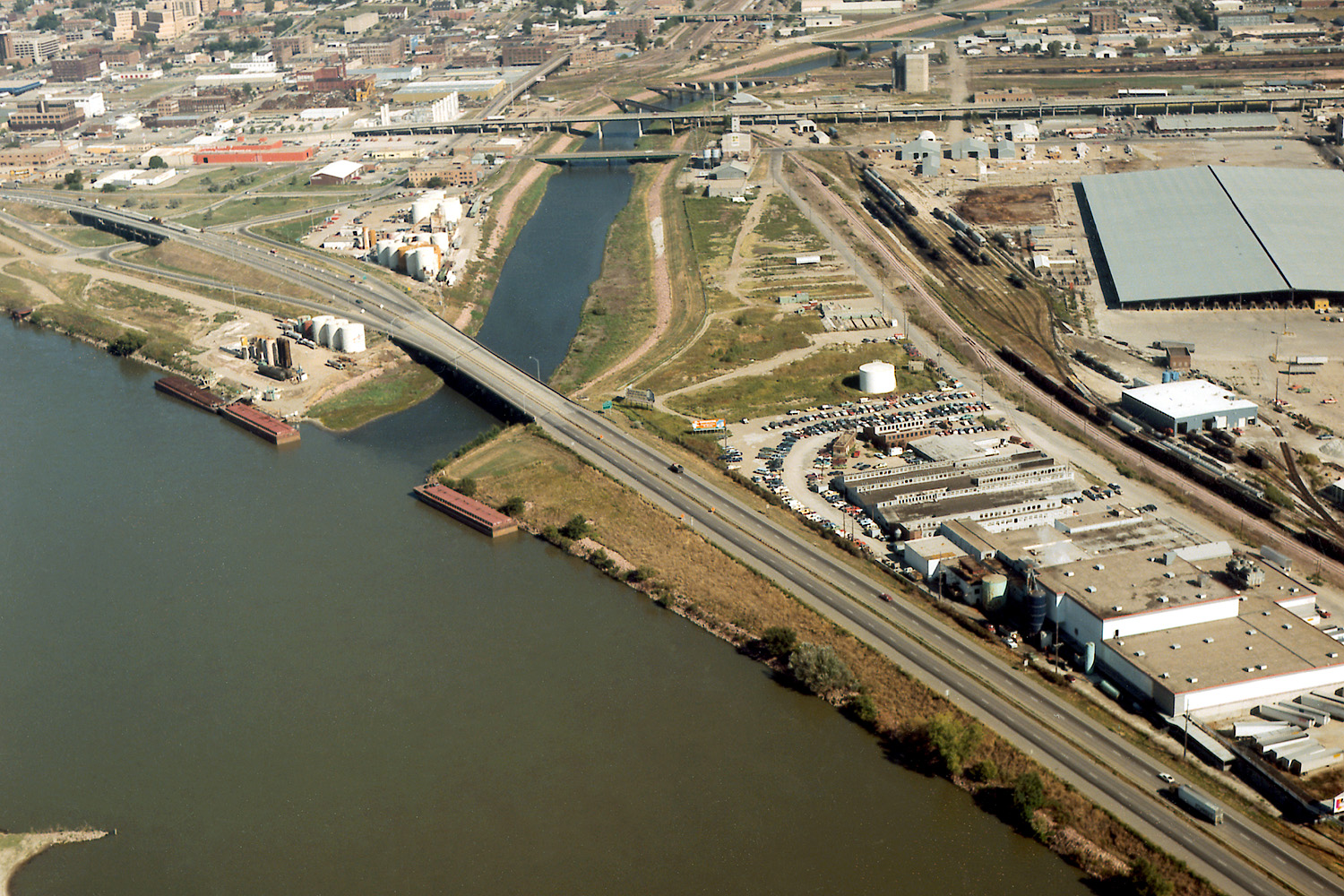
The river roughly defined the American frontier in the 19th century, particularly downstream from Kansas City, where it takes a sharp eastern turn into the heart of the state of Missouri, an area known as the Boonslick. As first area settled by Europeans along the river it was largely populated by slave-owning southerners following the Boone's Lick Road. The major trails for the opening of the American West all have their starting points on the river, including the California, Mormon, Oregon, and Santa Fe trails. The first westward leg of the Pony Express was a ferry across the Missouri at St. Joseph, Missouri. Similarly, most emigrants arrived at the eastern terminus of the First transcontinental railroad via a ferry ride across the Missouri between Council Bluffs, Iowa, and Omaha. |access-date=October 7, 2010 |archive-url=https://web.archive.org/web/20110726215500/http://www.history.com/topics/transcontinental-railroad |archive-date=July 26, 2011 |url-status=live The Hannibal Bridge became the first bridge to cross the Missouri River in 1869, and its location was a major reason why Kansas City became the largest city on the river upstream from its mouth at St. Louis. |access-date=October 7, 2010 |archive-url=https://web.archive.org/web/20120512010207/http://www.kclibrary.org/?q=blog/week-kansas-city-history/bridge-future |archive-date=May 12, 2012 |url-status=dead
True to the then-ideal of Manifest Destiny, over 500,000 people set out from the river town of Independence, Missouri, to their various destinations in the American West from the 1830s to the 1860s. These people had many reasons to embark on this strenuous year-long journey – economic crisis, and later gold strikes including the California Gold Rush, for example. |access-date=January 7, 2011 |archive-url=https://web.archive.org/web/20120503200231/http://www.nebraskahistory.org/publish/publicat/books/ourbooks/mattes.htm |archive-date=May 3, 2012 |url-status=usurped For most, the route took them up the Missouri to Omaha, Nebraska, where they would set out along the Platte River, which flows from the Rocky Mountains in Wyoming and Colorado eastward through the Great Plains. An early expedition led by Robert Stuart from 1812 to 1813 proved the Platte impossible to navigate by the dugout canoes they used, let alone the large sidewheelers and sternwheelers that would later ply the Missouri in increasing numbers. One explorer remarked that the Platte was "too thick to drink, too thin to plow". Nevertheless, the Platte provided an abundant and reliable source of water for the pioneers as they headed west. Covered wagons, popularly referred to as prairie schooners, provided the primary means of transport until the beginning of regular boat service on the river in the 1850s.
During the 1860s, gold strikes in Montana, Colorado, Wyoming, and northern Utah attracted another wave of hopefuls to the region. Although some freight was hauled overland, most transport to and from the gold fields was done through the Missouri and Kansas Rivers, as well as the Snake River in western Wyoming and the Bear River in Utah, Idaho, and Wyoming. It is estimated that of the passengers and freight hauled from the Midwest to Montana, over 80 percent were transported by boat, a journey that took 150 days in the upstream direction. A route more directly west into Colorado lay along the Kansas River and its tributary the Republican River as well as pair of smaller Colorado streams, Big Sandy Creek and the South Platte River, to near Denver. The gold rushes precipitated the decline of the Bozeman Trail as a popular emigration route, as it passed through land held by often-hostile Native Americans. Safer paths were blazed to the Great Salt Lake near Corinne, Utah, during the gold rush period, which led to the large-scale settlement of the Rocky Mountains region and eastern Great Basin.
.jpg)
As settlers expanded their holdings into the Great Plains, they ran into land conflicts with Native American tribes. This resulted in frequent raids, massacres and armed conflicts, leading to the federal government creating multiple treaties with the Plains tribes, which generally involved establishing borders and reserving lands for the indigenous. As with many other treaties between the U.S. and Native Americans, they were soon broken, leading to huge wars. Over 1,000 battles, big and small, were fought between the U.S. military and Native Americans before the tribes were forced out of their land onto reservations. |section-url=https://www.pbs.org/wgbh/americanexperience/features/tcrr-interview/ |access-date=October 5, 2010 |archive-url=https://web.archive.org/web/20110906013820/http://www.pbs.org/wgbh/americanexperience/features/interview/tcrr-interview/ |archive-date=September 6, 2011 |url-status=live |access-date=October 7, 2010 |archive-url=https://web.archive.org/web/20101109084007/http://www.history.army.mil/html/reference/army_flag/iw.html |archive-date=November 9, 2010 |url-status=dead
Conflicts between natives and settlers over the opening of the Bozeman Trail in the Dakotas, Wyoming and Montana led to Red Cloud's War, in which the Lakota and Cheyenne fought against the U.S. Army. The fighting resulted in a complete Native American victory.{{cite encyclopedia |access-date=October 5, 2010 |archive-url=https://web.archive.org/web/20091120071748/https://www.britannica.com/EBchecked/topic/1563057/Red-Clouds-War |archive-date=November 20, 2009 |url-status=live |access-date=November 10, 2010 |archive-url=https://web.archive.org/web/20101110032749/http://www.archives.gov/education/lessons/sioux-treaty/ |archive-date=November 10, 2010 |url-status=live |access-date=March 5, 2011 |archive-url=https://web.archive.org/web/20131110035105/http://www.cr.nps.gov/hps/abpp/battles/mo001.htm |archive-date=November 10, 2013 |url-status=dead
However, the peace and freedom of the Native Americans did not last for long. The Great Sioux War of 1876–77 was sparked when American miners discovered gold in the Black Hills of western South Dakota and eastern Wyoming. These lands were originally set aside for Native American use by the Treaty of Fort Laramie. When the settlers intruded onto the lands, they were attacked by Native Americans. U.S. troops were sent to the area to protect the miners, and drive out the natives from the new settlements. During this bloody period, both the Native Americans and the U.S. military won victories in major battles, resulting in the loss of nearly a thousand lives. The war eventually ended in an American victory, and the Black Hills were opened to settlement. Native Americans of that region were relocated to reservations in Wyoming and southeastern Montana.
Dam-building era
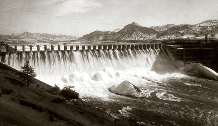
In the late 19th and early 20th centuries, a great number of dams were built along the course of the Missouri, transforming 35 percent of the river into a chain of reservoirs. River development was stimulated by a variety of factors, first by growing demand for electricity in the rural northwestern parts of the basin, and by floods and droughts that plagued rapidly growing agricultural and urban areas along the lower Missouri River. Small, privately owned hydroelectric projects have existed since the 1890s, but the large flood-control and storage dams that characterize the middle reaches of the river today were not constructed until the 1950s.
Between 1890 and 1940, five dams were built in the vicinity of Great Falls to generate power from the Great Falls of the Missouri, a chain of giant waterfalls formed by the river in its path through western Montana. Black Eagle Dam, built in 1891 on Black Eagle Falls, was the first dam of the Missouri. Replaced in 1926 with a more modern structure, the dam was little more than a small weir atop Black Eagle Falls, diverting part of the Missouri's flow into the Black Eagle power plant. |access-date = October 7, 2010 |archive-url = https://web.archive.org/web/20110715111220/http://www.pplmontana.com/producing+power/power+plants/Black+Eagle+Dam.htm |archive-date = July 15, 2011 |url-status = dead The largest of the five dams, Ryan Dam, was built in 1913. The dam lies directly above the 87 ft Big Falls, the largest waterfall of the Missouri. |access-date = October 8, 2010 |archive-url = https://web.archive.org/web/20100717143028/http://www.pplmontana.com/producing+power/power+plants/Ryan+Dam.htm |archive-date = July 17, 2010 |url-status = dead

In the same period, several private establishments – most notably the Montana Power Company – began to develop the Missouri River above Great Falls and below Helena for power generation. A small run-of-the river structure completed in 1898 near the present site of Canyon Ferry Dam became the second dam built on the Missouri. This rock-filled timber crib dam generated seven and a half megawatts of electricity for Helena and the surrounding countryside. The nearby steel Hauser Dam was finished in 1907, but failed in 1908 because of structural deficiencies, causing catastrophic flooding all the way downstream past Craig. At Great Falls, a section of the Black Eagle Dam was dynamited to save nearby factories from inundation. Hauser was rebuilt in 1910 as a concrete gravity structure, and stands to this day. |access-date = December 2, 2010 |url-status = dead |archive-url = https://web.archive.org/web/20100725181555/http://www.pplmontana.com/producing+power/power+plants/Hauser+Dam.htm |archive-date = July 25, 2010 |url-status=live |access-date=December 2, 2010 |archive-url=https://web.archive.org/web/20190322134725/https://helenair.com/news/local/article_ab5ce658-c9e1-5ade-a9c4-8b371a5ceecf.html |archive-date=March 22, 2019
Holter Dam, about 45 mi downstream of Helena, was the third hydroelectric dam built on this stretch of the Missouri River. |access-date = October 7, 2010 |url-status = dead |archive-url = https://web.archive.org/web/20100725201906/http://www.pplmontana.com/producing+power/power+plants/Holter+Dam.htm |archive-date = July 25, 2010 When completed in 1918 by the Montana Power Company and the United Missouri River Power Company, its reservoir flooded the Gates of the Mountains, a limestone canyon which Meriwether Lewis described as "the most remarkable clifts that we have yet seen ... the tow[er]ing and projecting rocks in many places seem ready to tumble on us." |access-date = January 16, 2012 |url-status = dead |archive-url = https://web.archive.org/web/20090205162342/http://www.mbmg.mtech.edu/gmr/lewis_clark/lewis_clark-gates.asp |archive-date = February 5, 2009 In 1949, the U.S. Bureau of Reclamation (USBR) began construction on the modern Canyon Ferry Dam to provide flood control to the Great Falls area. By 1954, the rising waters of Canyon Ferry Lake submerged the old 1898 dam, whose powerhouse still stands underwater about 1+1/2 mi upstream of the present-day dam. |url-status=dead |access-date=January 7, 2011 |archive-url=https://web.archive.org/web/20120927160231/http://www.usbr.gov/projects/Facility.jsp?fac_Name=Canyon+Ferry+Dam&groupName=General |archive-date=September 27, 2012
"uncertain as the actions of a jury or the state of a woman's mind".
The Missouri basin suffered a series of catastrophic floods around the turn of the 20th century, most notably in 1844, 1881, and 1926–1927. In 1940, as part of the Great Depression-era New Deal, the U.S. Army Corps of Engineers (USACE) completed Fort Peck Dam in Montana. Construction of this massive public works project provided jobs for more than 50,000 laborers during the Depression and was a major step in providing flood control to the lower half of the Missouri River. |access-date=January 16, 2012 |url-status=live |archive-url=https://web.archive.org/web/20110525033940/http://www.newwest.net/topic/article/dam_politics_could_a_project_like_fort_peck_get_built_today/C37/L37/ |archive-date=May 25, 2011 However, Fort Peck only controls runoff from 11 percent of the Missouri River watershed, and had little effect on a severe snowmelt flood that struck the lower basin three years later. This event was particularly destructive as it submerged manufacturing plants in Omaha and Kansas City, greatly delaying shipments of military supplies in World War II. |access-date = October 5, 2010 |url-status = dead |archive-url = https://web.archive.org/web/20110515083058/http://www.dnr.state.ne.us/floodplain/mitigation/mofloods.html |archive-date = May 15, 2011 |access-date = January 19, 2012 |url-status = dead |archive-url = https://web.archive.org/web/20120305153218/http://www.nwk.usace.army.mil/pa/History/timeline-1938-1947.pdf |archive-date = March 5, 2012

Flooding damages on the Mississippi–Missouri river system were one of the primary reasons for which Congress passed the Flood Control Act of 1944, opening the way for the USACE to develop the Missouri on a massive scale. |access-date=October 5, 2010 |url-status=live |archive-url=https://web.archive.org/web/20101203042456/http://www.fws.gov/laws/lawsdigest/FLOOD.HTML |archive-date=December 3, 2010 |access-date = March 10, 2012 |url-status = dead |archive-url = https://web.archive.org/web/20130120022019/http://www.msaconline.com/Missouri%20River%20Basin%20Project%20-%20The%20System.htm |archive-date = January 20, 2013 The 1944 act authorized the Pick–Sloan Missouri Basin Program (Pick–Sloan Plan), which was a composite of two widely varying proposals. The Pick plan, with an emphasis on flood control and hydroelectric power, called for the construction of large storage dams along the main stem of the Missouri. The Sloan plan, which stressed the development of local irrigation, included provisions for roughly 85 smaller dams on tributaries. |access-date = October 5, 2010 |url-status = dead |archive-url = https://web.archive.org/web/20110703062111/http://140.194.76.129/publications/eng-pamphlets/ep870-1-42/c-4-2.pdf |archive-date = July 3, 2011 |access-date=January 14, 2012 |url-status=dead |archive-url=https://web.archive.org/web/20120419163500/http://mo-rast.org/wp-content/uploads/2011/09/2011.09.27-Continued-Pick-Sloan-Presentation-Roger-Otstot.pdf |archive-date=April 19, 2012
In the early stages of Pick–Sloan development, tentative plans were made to build a low dam on the Missouri at Riverdale, North Dakota, and 27 smaller dams on the Yellowstone River and its tributaries. This was met with controversy from inhabitants of the Yellowstone basin, and eventually the USBR proposed a solution: to greatly increase the size of the proposed dam at Riverdale – today's Garrison Dam, thus replacing the storage that would have been provided by the Yellowstone dams. Because of this decision, the Yellowstone is now the longest free-flowing river in the contiguous United States. |access-date=January 14, 2012 |url-status=dead |archive-url=https://web.archive.org/web/20120309184038/http://library.fws.gov/Wetlands/upperyellowstone_01.pdf |archive-date=March 9, 2012 In the 1950s, construction commenced on the five mainstem dams – Garrison, Oahe, Big Bend, Fort Randall, and Gavins Point – proposed under the Pick-Sloan Plan. Along with Fort Peck, which was integrated as a unit of the Pick-Sloan Plan in the 1940s, these dams now form the Missouri River Mainstem System. |access-date = January 12, 2011 |url-status = dead |archive-url = https://web.archive.org/web/20130120022019/http://dnr.ne.gov/MissouriRiverActivities/pdf_files/MissouriRiver_MainstemSystem-Nov2010.pdf |archive-date = January 20, 2013
The flooding of lands along the Missouri River heavily impacted Native American groups whose reservations included fertile bottomlands and floodplains, especially in the arid Dakotas where it was some of the only good farmland they had. These consequences were pronounced in North Dakota's Fort Berthold Indian Reservation, where 150000 acre of land was taken by the construction of Garrison Dam. The Mandan, Hidatsa and Arikara / Sanish tribes sued the federal government on the basis of the 1851 Treaty of Fort Laramie which provided that reservation land could not be taken without the consent of both the tribes and Congress. After a lengthy legal battle the tribes were coerced in 1947 to accept a $5.1 million ($55 million today) settlement for the land, just $33 per acre. In 1949 this was increased to $12.6 million. The tribes were even denied the right to use the reservoir shore "for grazing, hunting, fishing, and other purposes". |access-date=December 13, 2016 |url-status=dead |archive-url=https://web.archive.org/web/20111007181537/http://www.ndstudies.org/resources/IndianStudies/threeaffiliated/historical_1900s_garrison.html |archive-date=October 7, 2011 |access-date=December 13, 2016 |url-status=live |archive-url=https://web.archive.org/web/20160304082339/http://www.nrcprograms.org/site/PageServer?pagename=airc_res_nd_fortberthold |archive-date=March 4, 2016
_1986_01.jpg)
The six dams of the Mainstem System, chiefly Fort Peck, Garrison, and Oahe, are among the largest dams in the world by volume; their sprawling reservoirs also rank among the biggest of the nation. |access-date=October 5, 2010 |url-status=dead |archive-url=https://web.archive.org/web/20120325153036/http://www.ussdams.org/uscold_s.html |archive-date=March 25, 2012 Holding up to 74.1 e6acre-ft in total, the six reservoirs can store more than three years' worth of the river's flow as measured below Gavins Point, the lowermost dam. This capacity makes it the largest reservoir system in the United States and one of the largest in North America. |access-date=January 15, 2012 |url-status=dead |archive-url=https://web.archive.org/web/20120112005247/http://www.epa.gov/region07/citizens/care/missouri.htm |archive-date=January 12, 2012 In addition to storing irrigation water, the system also includes an annual flood-control reservation of 16.3 e6acre-ft. Mainstem power plants generate about 9.3 billion KWh annually – equal to a constant output of almost 1,100 megawatts. |access-date=January 14, 2012 |url-status=live |archive-url=https://web.archive.org/web/20140812193753/http://news.yahoo.com/power-generation-missouri-river-dams-rebounds-182956078.html |archive-date=August 12, 2014 |access-date=January 19, 2012 |archive-url=https://web.archive.org/web/20130120022020/http://cedb.asce.org/cgi/WWWdisplay.cgi?152895 |archive-date=January 20, 2013 |url-status=dead
:{| class="wikitable sortable mw-collapsible collapsible collapsed" style="width:47%; left;" |- !colspan=6|Dams on the Missouri River |- style="font-size:9pt" !Dam !State(s) !Height !Reservoir !Capacity (Acre.ft) !Capacity (MW) |- style="font-size:9pt" !scope="row" |Toston |MT | ft (17 m) | |3,000 |- style="font-size:9pt" !scope="row" |Canyon Ferry |MT | ft (69 m) |Canyon Ferry Lake |1,973,000 |50 |- style="font-size:9pt" !scope="row" |Hauser |MT | ft (24 m) |Hauser Lake |98,000 |19 |- style="font-size:9pt" !scope="row" |Holter |MT | ft (38 m) |Holter Lake |243,000 |48 |- style="font-size:9pt" !scope="row" |Black Eagle |MT | ft (4.0 m) |Long Pool{{efn| "Long Pool" is the name used by area residents to refer to the smooth, almost lake-like 55 mi stretch of the Missouri between the Black Eagle Dam and the town of Cascade. Only about 2 mi of the so-called Long Pool are actually part of the impoundment behind the dam. |2,000 |- style="font-size:9pt" !scope="row" |Rainbow |MT | ft (8.8 m) | |1,000 |- style="font-size:9pt" !scope="row" |Cochrane |MT | ft (18 m) | |3,000 |- style="font-size:9pt" !scope="row" |Ryan |MT | ft (19 m) | |5,000 |- style="font-size:9pt" !scope="row" |Morony |MT | ft (18 m) | |3,000 |- style="font-size:9pt" ! scope="row" style="background:#7fffd4;"|Fort Peck |MT | ft (76 m) |Fort Peck Lake |18,690,000 |185 |- style="font-size:9pt" ! scope="row" style="background:#7fffd4;"|Garrison |ND | ft (64 m) |Lake Sakakawea |23,800,000 |515 |- style="font-size:9pt" ! scope="row" style="background:#7fffd4;"|Oahe |SD | ft (75 m) |Lake Oahe |23,500,000 |786 |- style="font-size:9pt" ! scope="row" style="background:#7fffd4;"|Big Bend |SD | ft (29 m) |Lake Sharpe |1,910,000 |493 |- style="font-size:9pt" ! scope="row" style="background:#7fffd4;"|Fort Randall |SD | ft (50 m) |Lake Francis Case |5,700,000 |320 |- style="font-size:9pt" ! scope="row" style="background:#7fffd4;"|Gavins Point |NE SD | ft (23 m) |Lewis and Clark Lake |492,000 |132 |- style="font-size:9pt" class="sortbottom" !scope="row" |Total |}
The table at left lists statistics of all fifteen dams on the Missouri River, ordered downstream. Many of the run-of-the-river power generation dams on the Missouri (marked in yellow) form very small impoundments which may or may not have been given names; those unnamed are left blank. All dams are on the upper half of the river above Sioux City; the lower river is uninterrupted due to its longstanding use as a shipping channel. |access-date = March 19, 2011 |archive-url = https://web.archive.org/web/20110614033558/http://nd.water.usgs.gov/lewisandclark/dams.html |archive-date = June 14, 2011 |url-status = dead
Navigation
"never achieved its expectations. Even under the very best of circumstances, it was never a huge industry".
— Richard Opper, former executive director Missouri River Basin Association
_aground.jpg)
Boat travel on the Missouri began with the wood-framed canoes and bull boats that Native Americans used for thousands of years before the colonization of the Great Plains introduced larger craft to the river.{{cite web |access-date=January 28, 2012 |archive-url=https://web.archive.org/web/20110813062607/http://history.nd.gov/activities/riverboats.pdf |archive-date=August 13, 2011 |url-status=dead |access-date=January 28, 2012 |archive-url=https://web.archive.org/web/20120507021750/http://nebraskahistory.org/archeo/pubs/Engineer%20Cantonment.pdf |archive-date=May 7, 2012 |url-status=usurped
During the early 19th century, at the height of the fur trade, steamboats and keelboats travelled nearly the whole length of the Missouri from Montana's rugged Missouri Breaks to the mouth, carrying beaver and buffalo furs to and from the areas the trappers frequented. This resulted in the development of the Missouri River mackinaw, which specialized in carrying furs. Since these boats could only travel downriver, they were dismantled and sold for lumber upon their arrival at St. Louis.
Water transport increased through the 1850s with multiple craft ferrying pioneers, emigrants and miners; many of these runs were from St. Louis or Independence to near Omaha. There, most of these people would set out overland along the large but shallow and unnavigable Platte River, which pioneers described as "a mile wide and an inch deep" and "the most magnificent and useless of rivers". Steamboat navigation peaked in 1858 with over 130 boats operating full-time on the Missouri, with many more smaller vessels. Many of the earlier vessels were built on the Ohio River before being transferred to the Missouri. Side-wheeler steamboats were preferred over the larger sternwheelers used on the Mississippi and Ohio because of their greater maneuverability. |access-date=October 18, 2010 |url-status=live |archive-url=https://web.archive.org/web/20101128113801/http://riverboatdaves.com/docs/moboats.html |archive-date=November 28, 2010
.jpg)
]]
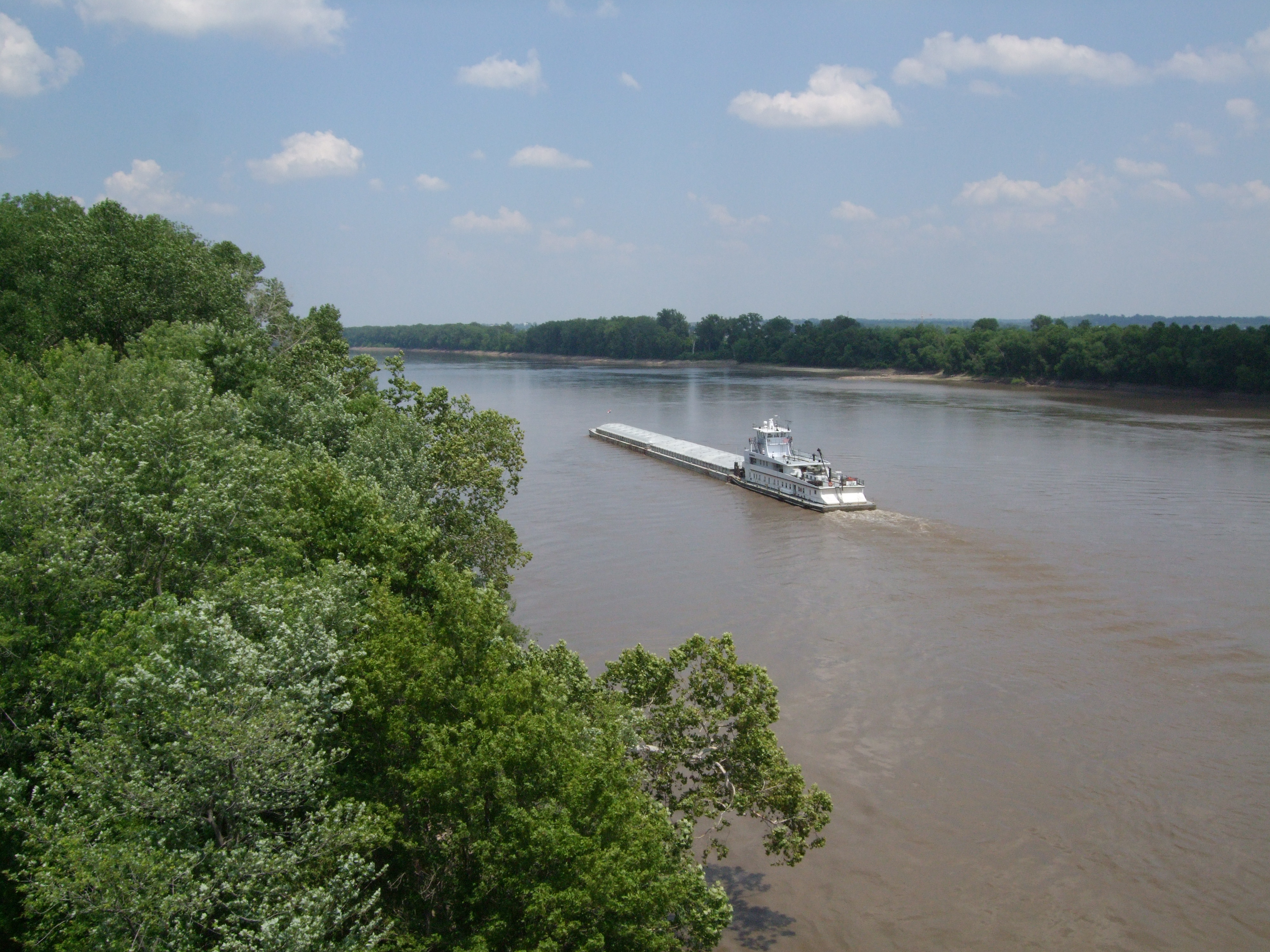
The industry's success, however, did not guarantee safety. In the early decades before man controlled the river's flow, its sketchy rises and falls and its massive amounts of sediment, which prevented a clear view of the bottom, wrecked some 300 vessels. Because of the dangers of navigating the Missouri River, the average ship's lifespan was only about four years. The development of the Transcontinental and Northern Pacific Railroads marked the beginning of the end of steamboat commerce on the Missouri. Outcompeted by trains, the number of boats slowly dwindled, until there was almost nothing left by the 1890s. Transport of agricultural and mining products by barge, however, saw a revival in the early twentieth century. |access-date = October 17, 2010 |url-status = dead |archive-url = https://web.archive.org/web/20160305031416/http://www.nebraskastudies.org/0400/frameset_reset.html?http%3A%2F%2Fwww.nebraskastudies.org%2F0400%2Fstories%2F0401_0141.html |archive-date = March 5, 2016
Passage to Sioux City
Since the beginning of the 20th century, the Missouri River has been extensively engineered for water transport purposes, and about 32 percent of the river now flows through artificially straightened channels. In 1912, the USACE was authorized to maintain the Missouri to a depth of 6 ft from the Port of Kansas City to the mouth, a distance of 368 mi. This was accomplished by constructing levees and wing dams to direct the river's flow into a straight, narrow channel and prevent sedimentation. In 1925, the USACE began a project to widen the river's navigation channel to 200 ft; two years later, they began dredging a deep-water channel from Kansas City to Sioux City. These modifications have reduced the river's length from some 2540 mi in the late 19th century to 2341 mi in the present day. |access-date = October 1, 2010 |url-status = dead |archive-url = https://web.archive.org/web/20100831064632/http://www.rivers.gov/waterfacts.html |archive-date = August 31, 2010 |df = mdy-all

Construction of dams on the Missouri under the Pick-Sloan Plan in the mid-twentieth century was the final step in aiding navigation. The large reservoirs of the Mainstem System help provide a dependable flow to maintain the navigation channel year-round, and are capable of halting most of the river's annual freshets. |access-date=October 7, 2010 |archive-url = https://web.archive.org/web/20070211195723/http://www.nwk.usace.army.mil/projects/mitigation/projectistory.htm |archive-date = February 11, 2007 However, high and low water cycles of the Missouri – notably the protracted early-21st-century drought in the Missouri River basin |access-date=January 14, 2012 |archive-url=https://web.archive.org/web/20120113063155/http://www.usatoday.com/news/nation/2005-04-28-muddy_x.htm |archive-date=January 13, 2012 |url-status=live and historic floods in 1993 |section-url=http://www.nwrfc.noaa.gov/floods/papers/oh_2/great.htm |access-date=January 14, 2012 |archive-url=https://web.archive.org/web/20120126102203/http://www.nwrfc.noaa.gov/floods/papers/oh_2/great.htm |archive-date=January 26, 2012 |url-status=live and 2011 |access-date=January 14, 2012 – are difficult for even the massive Mainstem System reservoirs to control.
In 1945, the USACE began the Missouri River Bank Stabilization and Navigation Project, which would permanently increase the river's navigation channel to a width of 300 ft and a depth of 9 ft. During work that continues to this day, the 735 mi navigation channel from Sioux City to St. Louis has been controlled by building rock dikes to direct the river's flow and scour out sediments, sealing and cutting off meanders and side channels, and dredging the riverbed. |access-date=October 7, 2010 |archive-url = https://web.archive.org/web/20070627040444/http://www.nwk.usace.army.mil/projects/mitigation/bankstabilization.htm |archive-date = June 27, 2007 However, the Missouri has often resisted the efforts of the USACE to control its depth. In 2006, the U.S. Coast Guard stated that commercial barge tows ran aground in the Missouri River because the navigation channel had been severely silted. |access-date = October 7, 2010 |url-status = dead |archive-url = https://web.archive.org/web/20100528112204/http://ago.mo.gov/newsreleases/2006/072606.htm |archive-date = May 28, 2010 The USACE was blamed for failing to maintain the channel to the minimum depth. |access-date = October 7, 2010 |url-status = dead |archive-url = https://web.archive.org/web/20100528115526/http://ago.mo.gov/pdf/2006/MartinLetter072606.pdf |archive-date = May 28, 2010

In 1929, the Missouri River Navigation Commission estimated the amount of goods shipped on the river annually at 15 million tons (13.6 million metric tons), providing widespread consensus for the creation of a navigation channel. However, shipping traffic has since been far lower than expected – shipments of commodities including produce, manufactured items, lumber, and oil averaged only 683,000 tons (616,000 t) per year from 1994 to 2006. |access-date=October 7, 2010 |archive-url=https://web.archive.org/web/20101106184620/http://www.gao.gov/new.items/d09224r.pdf |archive-date=November 6, 2010 |url-status=live
By tonnage of transported material, Missouri is by far the largest user of the river accounting for 83 percent of river traffic, while Kansas has 12 percent, Nebraska three percent and Iowa two percent. Almost all of the barge traffic on the Missouri River ships sand and gravel dredged from the lower 500 mi of the river; the remaining portion of the shipping channel now sees little to no use by commercial vessels.
For navigation purposes, the Missouri River is divided into two main sections. The Upper Missouri River is north of Gavins Point Dam, the last hydroelectric dam of fifteen on the river, just upstream from Sioux City, Iowa. The Lower Missouri River is the 840 mi of river below Gavins Point until it meets the Mississippi just above St. Louis. The Lower Missouri River has no hydroelectric dams or locks but it has a plethora of wing dams that enable barge traffic by directing the flow of the river into a 200 ft, 12 ft channel. These wing dams have been put in place by and are maintained by the U.S. Army Corps of Engineers, and there are no plans to construct any locks to replace these wing dams on the Missouri River.
Traffic decline
Tonnage of goods shipped by barges on the Missouri River has seen a serious decline from the 1960s to the present. In the 1960s, the USACE predicted an increase to 12 e6ST per year by 2000, but instead the opposite has happened. The amount of goods plunged from 3.3 e6ST in 1977 to just 1.3 e6ST in 2000. |access-date = October 7, 2010 |archive-url = https://web.archive.org/web/20120516094516/http://www.iatp.org/files/Past_and_Future_Grain_Traffic_on_the_Missouri_.pdf |archive-date = May 16, 2012 |url-status = dead One of the largest drops has been in agricultural products, especially wheat. Part of the reason is that irrigated land along the Missouri has only been developed to a fraction of its potential. In 2006, barges on the Missouri hauled only 200000 ST of products which is equal to the daily freight traffic on the Mississippi. |access-date=October 7, 2010 |archive-url=https://web.archive.org/web/20120321062645/http://www.prairiefirenewspaper.com/2007/12/missouri-river |archive-date=March 21, 2012 |url-status=dead
Drought conditions in the early 21st century and competition from other modes of transport – mainly railroads – are the primary reason for decreasing river traffic on the Missouri. The USACE's failure to consistently maintain the navigation channel has also hampered the industry. Efforts are being made to revive the shipping industry on the Missouri River, because of the efficiency and cheapness of river transport to haul agricultural products, and the overcrowding of alternative transportation routes. Solutions such as expanding the navigation channel and releasing more water from reservoirs during the peak of the navigation season are under consideration. |access-date=October 7, 2010 Drought conditions lifted in 2010, in which about 334000 ST were barged on the Missouri, representing the first significant increase in shipments since 2000. However, flooding in 2011 closed record stretches of the river to boat traffic – "wash[ing] away hopes for a bounce-back year".{{cite news |access-date = January 21, 2012 |url-status = dead |archive-url = https://archive.today/20130119163513/http://www.columbiamissourian.com/stories/2011/07/23/missouri-river-flooding-closure-impacting-barge-industry/ |archive-date = January 19, 2013
There are no lock and dams on the lower Missouri River, but there are plenty of wing dams that jettie out into the river and make it harder for barges to navigate. In contrast, the upper Mississippi has 29 locks and dams and averaged 61.3 million tons of cargo annually from 2008 to 2011, and its locks are closed in the winter. |access-date=September 19, 2014 |archive-url=https://web.archive.org/web/20140811003512/http://afcerc.tamu.edu/publications/Publication-PDFs/CP%2002%2002%20Lock%20Delay.pdf |archive-date=August 11, 2014 |url-status=live
Ecology
Natural history

Historically, the thousands of square miles that comprised the floodplain of the Missouri River supported a wide range of plant and animal species. Biodiversity generally increased proceeding downstream from the cold, subalpine headwaters in Montana to the temperate, moist climate of Missouri. Today, the river's riparian zone consists primarily of cottonwoods, willows and sycamores, with several other types of trees such as maple and ash. Average tree height generally increases farther from the riverbanks for a limited distance, as land next to the river is vulnerable to soil erosion during floods. Because of its large sediment concentrations, the Missouri does not support many aquatic invertebrates. However, the basin supports about 300 species of birds and 150 species of fish, |access-date=October 8, 2010 |url-status=dead |archive-url=https://web.archive.org/web/20080917075113/http://www.npwrc.usgs.gov/resource/fish/othrfish/overview.htm |archive-date=September 17, 2008 some of which are endangered such as the pallid sturgeon. The Missouri's aquatic and riparian habitats also support several species of mammals, such as minks, river otters, beavers, muskrats, and raccoons.
The World Wide Fund For Nature divides the Missouri River watershed into three freshwater ecoregions: the Upper Missouri, Lower Missouri and Central Prairie. The Upper Missouri, roughly encompassing the area within Montana, Wyoming, southern Alberta and Saskatchewan, and North Dakota, comprises mainly semiarid shrub-steppe grasslands with sparse biodiversity because of Ice Age glaciations. There are no known endemic species within the region. Except for the headwaters in the Rockies, there is little precipitation in this part of the watershed. |access-date = October 8, 2010 |url-status = dead |archive-url = https://web.archive.org/web/20111005204635/http://www.feow.org/ecoregion_details.php?eco=142 |archive-date = October 5, 2011 The Middle Missouri ecoregion, extending through Colorado, southwestern Minnesota, northern Kansas, Nebraska, and parts of Wyoming and Iowa, has greater rainfall and is characterized by temperate forests and grasslands. Plant life is more diverse in the Middle Missouri, which is also home to about twice as many animal species.{{cite web |access-date = October 8, 2010 |url-status = dead |archive-url = https://web.archive.org/web/20111005204635/http://www.feow.org/ecoregion_details.php?eco=142 |archive-date = October 5, 2011 |access-date = October 8, 2010 |url-status = dead |archive-url = https://web.archive.org/web/20111005204643/http://www.feow.org/ecoregion_details.php?eco=146 |archive-date = October 5, 2011
Human impacts

Since river commerce and industrial development began in the 1800s, human activity has severely polluted the Missouri and degraded its water quality. Most of the river's floodplain habitat is long gone, replaced by irrigated agricultural land. Development of the floodplain has led to increasing numbers of people and infrastructure within areas at high risk of inundation. Levees have been constructed along more than a third of the river to keep floodwater within the channel, but with the consequences of faster stream velocity and a resulting increase of peak flows in downstream areas. Fertilizer runoff, which causes elevated levels of nitrogen and other nutrients, is a major problem along the Missouri River, especially in Iowa and Missouri. This form of pollution also affects the upper Mississippi, Illinois and Ohio Rivers. Low oxygen levels in rivers and the vast Gulf of Mexico dead zone at the end of the Mississippi Delta are both results of high nutrient concentrations in the Missouri and other tributaries of the Mississippi.
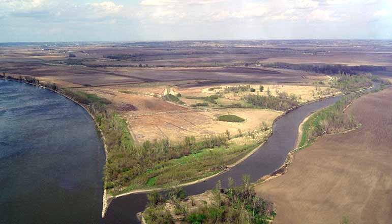
Channelization of the lower Missouri waters has made the river narrower, deeper and less accessible to riparian flora and fauna. Many dams and bank stabilization projects have been built to help convert 300000 acre of Missouri River floodplain to agricultural land. Channel control has reduced the volume of sediment transported downstream by the river and eliminated critical habitat for fish, birds and amphibians. |access-date=October 20, 2010 |url-status=live |archive-url=https://web.archive.org/web/20120516055440/http://digitalcommons.unl.edu/cgi/viewcontent.cgi?article=1022&context=nebgamewhitepap |archive-date=May 16, 2012 By the early 21st century, declines in populations of native species prompted the U.S. Fish and Wildlife Service to issue a biological opinion recommending restoration of river habitats for federally endangered bird and fish species. |section-url=http://www.fws.gov/mountain-prairie/pressrel/03-87.htm |access-date=January 19, 2011 |url-status=live |archive-url=https://web.archive.org/web/20120321080733/http://www.fws.gov/mountain-prairie/pressrel/03-87.htm |archive-date=March 21, 2012
The USACE began work on ecosystem restoration projects along the lower Missouri River in the early 21st century. Because of the low use of the shipping channel in the lower Missouri maintained by the USACE, it is now considered feasible to remove some of the levees, dikes, and wing dams that constrict the river's flow, thus allowing it to naturally restore its banks. By 2001, there were 87000 acre of riverside floodplain undergoing active restoration. |url-status=dead |archive-url=https://web.archive.org/web/20010608181325/http://www.uswaternews.com/archives/arcpolicy/1misriv5.html |archive-date=June 8, 2001 |access-date=March 11, 2014
Restoration projects have re-mobilized some of the sediments that had been trapped behind bank stabilization structures, prompting concerns of exacerbated nutrient and sediment pollution locally and downstream in the northern Gulf of Mexico. A 2010 National Research Council report assessed the roles of sediment in the Missouri River, evaluating current habitat restoration strategies and alternative ways to manage sediment. |access-date=July 22, 2011 |archive-url=https://web.archive.org/web/20120602143710/http://dels.nas.edu/Report/Missouri-River-Planning-Recognizing-Incorporating/13019 |archive-date=June 2, 2012 |url-status=live The report found that a better understanding of sediment processes in the Missouri River, including the creation of a "sediment budget" – an accounting of sediment transport, erosion, and deposition volumes for the length of the Missouri River – would provide a foundation for projects to improve water quality standards and protect endangered species. |access-date=July 22, 2011 |archive-url=https://web.archive.org/web/20120430095336/http://dels.nas.edu/Materials/Report-In-Brief/4336-Missouri-River-Planning |archive-date=April 30, 2012 |url-status=dead
National Wild and Scenic River
Several sections of the Missouri River were added to the National Wild and Scenic Rivers System from Fort Benton to Robinson Bridge, Gavins Point Dam to Ponca State Park and Fort Randall Dam to Lewis and Clark Lake. A total of 247 mi of the river were designated including 64 mi of wild river and 26 mi of scenic river in Montana. 157 mi of the river is listed as recreational under the National Wild and Scenic Rivers System.
Tourism and recreation

With over 1500 mi2 of open water, the six reservoirs of the Missouri River Mainstem System provide some of the main recreational areas within the basin. Visitation has increased from 10 million visitor-hours in the mid-1960s to over 60 million visitor-hours in 1990. Development of visitor facilities was spurred by the Federal Water Project Recreation Act of 1965, which required the USACE to build and maintain boat ramps, campgrounds and other public facilities along major reservoirs. Recreational use of Missouri River reservoirs is estimated to contribute $85–100 million to the regional economy each year. |access-date = January 16, 2012 |url-status = dead |archive-url = https://web.archive.org/web/20111012155902/http://www.swc.state.nd.us/4dlink9/4dcgi/GetSubCategoryPDF/201/TodaysMissouriRiver.pdf |archive-date = October 12, 2011
The Lewis and Clark National Historic Trail, some 3700 mi long, follows nearly the entire Missouri River from its mouth to its source, retracing the route of the Lewis and Clark Expedition. Extending from Wood River, Illinois, in the east, to Astoria, Oregon, in the west, it also follows portions of the Mississippi and Columbia Rivers. The trail, which spans through eleven U.S. states, is maintained by various federal and state government agencies; it passes through some 100 historic sites, notably archaeological locations including the Knife River Indian Villages National Historic Site.
Parts of the river itself are designated for recreational or preservational use. The Missouri National Recreational River consists of portions of the Missouri downstream from Fort Randall and Gavins Point Dams that total 98 mi.{{cite web |access-date=October 11, 2010 |archive-url=https://web.archive.org/web/20100829075021/http://www.nps.gov/mnrr/planyourvisit/canoeing-and-kayaking.htm |archive-date=August 29, 2010 |url-status=live |access-date=October 11, 2010 |archive-url=https://web.archive.org/web/20101010053130/http://www.nps.gov/mnrr/index.htm |archive-date=October 10, 2010 |url-status=live |access-date=October 11, 2010 |archive-url=https://web.archive.org/web/20110614031312/http://www.nature.nps.gov/water/planning/Info_Issuesoverview_reports/MNRR_IssuesOverview.pdf |archive-date=June 14, 2011 |url-status=dead |access-date = January 16, 2012 |url-status = dead |archive-url = https://web.archive.org/web/20120516053936/http://snr.unl.edu/gpcesu/PDFs/Shipwrecks_missouri.pdf |archive-date = May 16, 2012
Downstream from Great Falls, Montana, about 149 mi of the river course through a rugged series of canyons and badlands known as the Missouri Breaks. This part of the river, designated a U.S. National Wild and Scenic River in 1976, flows within the Upper Missouri Breaks National Monument, a 375000 acre preserve comprising steep cliffs, deep gorges, arid plains, badlands, archaeological sites, and whitewater rapids on the Missouri itself. The preserve includes a wide variety of plant and animal life; recreational activities include boating, rafting, hiking and wildlife observation.{{cite web |access-date = October 12, 2010 |url-status = dead |archive-url = https://web.archive.org/web/20120103073836/http://www.blm.gov/pgdata/content/mt/en/fo/umrbnm.html |archive-date = January 3, 2012 |access-date = October 12, 2010 |url-status = dead |archive-url = https://web.archive.org/web/20110727085905/http://www.missouribreaks.org/PDFs/twsmap2.pdf |archive-date = July 27, 2011
In north-central Montana, some 1100000 acre along over 125 mi of the Missouri River, centering on Fort Peck Lake, comprise the Charles M. Russell National Wildlife Refuge.{{cite web |access-date=October 11, 2010 |archive-url=https://web.archive.org/web/20101007232151/http://www.fws.gov/cmr/ |archive-date=October 7, 2010 |url-status=live |access-date=October 11, 2010 |archive-url=https://web.archive.org/web/20120209041622/http://www.fws.gov/refuges/profiles/index.cfm?id=61520 |archive-date=February 9, 2012 |url-status=live
Many U.S. national parks, such as Glacier National Park, Rocky Mountain National Park, Yellowstone National Park and Badlands National Park are, at least partially, in the watershed. Parts of other rivers in the basin are set aside for preservation and recreational use – notably the Niobrara National Scenic River, which is a 76 mi protected stretch of the Niobrara River, one of the Missouri's longest tributaries.{{cite web |access-date=October 12, 2010 |archive-url=https://web.archive.org/web/20100829074426/http://www.nps.gov/niob/naturescience/index.htm |archive-date=August 29, 2010 |url-status=live |access-date=February 24, 2011 |archive-url=https://web.archive.org/web/20101130180243/http://www.nps.gov/nr/travel/lewisandclark/thr.htm |archive-date=November 30, 2010 |url-status=dead |access-date = March 3, 2011 |url-status = dead |archive-url = https://web.archive.org/web/20120510141616/http://www.blm.gov/mt/st/en/fo/umrbnm/ftbenton.html |archive-date = May 10, 2012 |access-date=March 3, 2011 |archive-url=https://web.archive.org/web/20110111011603/http://www.nps.gov/nr/travel/lewisandclark/atk.htm |archive-date=January 11, 2011 |url-status=dead |access-date=March 3, 2011 |archive-url=https://web.archive.org/web/20110308034734/http://mostateparks.com/park/arrow-rock-state-historic-site |archive-date=March 8, 2011 |url-status=live
Notes
References
Works cited
- {{cite book |title=Wild mammals of North America: Biology, management, and conservation
References
- (1988). "Uniquely South Dakota". Donning Company.
- (2011). "New Lakota Dictionary". Lakota Language Consortium.
- "Spotlight on the Big Muddy".
- {{cite gnis
- "Hydrologic History of the Lower Missouri River". Southern Illinois University.
- link. (October 17, 2014 [[United States Geological Survey). USGS]] topographic map of the source
- {{cite gnis
- Howard Perlman, USGS. (October 31, 2012). "Lengths of major rivers".
- "Largest Rivers in the United States". [[United States Geological Survey]].
- "United States Geological Survey Topographic Maps". U.S. Geological Survey.
- "USGS Topo Maps for United States".
- (1941–2010). "USGS Gage #06185500 on the Missouri River near Culbertson, MT". U.S. Geological Survey.
- (1911–2010). "USGS Gage #06329000 on the Yellowstone River near Sidney, MT". U.S. Geological Survey.
- "{{grey".
- {{harvp. Athearn. 1965
- (1897–2009). "USGS Gage #06934500 on the Missouri River at Hermann, Missouri: Water-Data Report 2009". U.S. Geological Survey.
- (1861–2009). "USGS Gage #07010000 on the Mississippi River at St. Louis, Missouri: Water-Data Report 2009". U.S. Geological Survey.
- "Mount Lincoln, Colorado".
- "National Weather Service".
- "Great Divide Basin". Wyoming State Geological Survey.
- (1953–2009). "USGS Gage #06805500 on the Platte River at Louisville, NE". U.S. Geological Survey.
- {{harvp. McFarlan. McWhirter. 1992
- Kammerer, J.C.. (May 1990). "Largest Rivers in the United States". U.S. Geological Survey.
- "Boundary Descriptions and Names of Regions, Subregions, Accounting Units and Cataloging Units". U.S. Geological Survey.
- "The National Map". U.S. Geological Survey.
- (1917–2010). "USGS Gage #06892350 on the Kansas River at DeSoto, KS". U.S. Geological Survey.
- (1940–2010). "USGS Gage #06174500 on the Milk River at Nashua, MT". U.S. Geological Survey.
- (1928–2009). "USGS Gage #06478500 on the James River near Scotland, SD". U.S. Geological Survey.
- Miller, Kirk A.. (1999). "Environmental Setting of the Yellowstone River Basin, Montana, North Dakota, and Wyoming". U.S. Geological Survey.
- (1928–2009). "USGS Gage #06452000 on the White River near Oacoma, SD". U.S. Geological Survey.
- (1928–2009). "USGS Gage #06465500 on the Niobrara River near Verdel, NE". U.S. Geological Survey.
- (1935–2009). "USGS Gage #06337000 on the Little Missouri River near Watford City, ND". U.S. Geological Survey.
- (1996–2009). "USGS Gage #06926510 on the Osage River below St. Thomas, MO". U.S. Geological Survey.
- (1929–2009). "USGS Gage #06485500 on the Big Sioux River at Akron, IA". U.S. Geological Survey.
- (1957–2010). "USGS Gage #06934500 on the Missouri River at Hermann, Missouri: Monthly Average Flow". U.S. Geological Survey.
- "Missouri River at Great Falls, Montana". Center for Sustainability and the Global Environment (SAGE), Gaylord Nelson Institute for Environmental Studies, University of Wisconsin.
- (1934–1965). "USGS Gage #06440000 on the Missouri River at Pierre, SD". U.S. Geological Survey.
- (1953–2009). "USGS Gage #06486000 on the Missouri River at Sioux City, IA". U.S. Geological Survey.
- (1953–2009). "USGS Gage #06610000 on the Missouri River at Omaha, NE". U.S. Geological Survey.
- (1958–2009). "USGS Gage #06909000 on the Missouri River at Boonville, MO". U.S. Geological Survey.
- (1844–2009). "USGS Gage #07010000 on the Mississippi River at St. Louis, Missouri: Peak Streamflow". U.S. Geological Survey.
- Jones, Craig H.. "Photo map of the western United States: Cenozoic". University of Colorado.
- {{harvp. King. 1971
- {{harvp. King. 1971
- {{harvp. Baldridge. 2004
- {{harvp. Roberts. Hodsdon. 2001
- {{harvp. Benke. Cushing. 2005
- "White River Formation". U.S. Geological Survey.
- "White River Formation". U.S. Geological Survey.
- "Arikaree Group". U.S. Geological Survey.
- {{harvp. King. 1971
- {{harvp. Thornbury. 1965
- {{harvp. Thornbury. 1965
- "Montana Sapphires".
- Voynick, Stephen M.. (1987). "Yogo The Great American Sapphire". Mountain Press Publishing.
- {{harvp. Benke. Cushing. 2005
- {{harvp. Benke. Cushing. 2005
- {{harvp. Edwards. 1987
- {{harvp. Lott. Greene. 2003
- {{harvp. Feldhamer. Thompson. Chapman. 2003
- {{harvp. Lott. Greene. 2003
- {{harvp. Houck. 1908
- {{harvp. Kellogg. 1917
- {{harvp. Houck. 1908
- "Pinckney's Treaty or Treaty of San Lorenzo".
- {{harvp. Morris. 1912
- {{harvp. South Dakota State Historical Society. South Dakota Department of History. 1902
- {{harvp. Sunder. 1993
- {{harvp. Sunder. 1993
- {{harvp. Sunder. 1993
- {{harvp. Dick. 1971
- Cech, p. 424
- Mattes, pp. 4–11
- Holmes, Walter and Dailey, pp. 105–106
- Athearn, pp. 87–88
- {{harvp. Greene. 2003. xv–xxvi
- ''Montana: A State Guide Book'', p. 150
- {{harvp. Mulvaney. 2008
- {{harvp. Mulvaney. 2008
- "Toston Dam (Broadwater-Missouri)". Montana Department of Natural Resources and Conservation.
- "Rainbow Dam".
- "Cochrane Dam".
- "Morony Dam".
- "Fort Peck Dam / Fort Peck Lake". U.S. Army Corps of Engineers.
- Wilson, Ron. (June 2003). "Garrison Dam: A half-century later". North Dakota Game and Fish Department.
- (September 2010). "Final Oahe Dam / Lake Oahe Master Plan: Missouri River, South Dakota and North Dakota". U.S. Army Corps of Engineers.
- "Big Bend Dam/Lake Sharpe". U.S. Army Corps of Engineers.
- "Fort Randall Dam / Lake Francis Case". U.S. Army Corps of Engineers.
- "Gavins Point Dam / Lewis & Clark Lake". U.S. Army Corps of Engineers.
- (May 26, 2010). "Long dry spells cut into Missouri River navigation". News Tribune.
- Demoth, p. 101
- Rogers, Brown, and Garbrecht, p. 113
- Dyer, p. 2
- (August 2, 2007). "CERC Science Topic: Missouri River".
- (March 13, 2014). "About the Upper Mississippi River System". U.S. Geological Survey.
- (November 30, 2012). "Upper Mississippi River navigation season ending". Milwaukee Journal Sentinel.
- {{harvp. Benke. Cushing. 2005
- {{harvp. Benke. Cushing. 2005
- {{harvp. Singer. 1970
- "Lewis and Clark National Historic Trail". U.S. National Park Service.
- "Lewis and Clark National Historic Trail". National Parks Conservation Association.
- "National Historic Landmark Summary Listing". U.S. National Park Service.
This article was imported from Wikipedia and is available under the Creative Commons Attribution-ShareAlike 4.0 License. Content has been adapted to SurfDoc format. Original contributors can be found on the article history page.
Ask Mako anything about Missouri River — get instant answers, deeper analysis, and related topics.
Research with MakoFree with your Surf account
Create a free account to save articles, ask Mako questions, and organize your research.
Sign up freeThis content may have been generated or modified by AI. CloudSurf Software LLC is not responsible for the accuracy, completeness, or reliability of AI-generated content. Always verify important information from primary sources.
Report