From Surf Wiki (app.surf) — the open knowledge base
Mineral County, Nevada
County in Nevada, United States
County in Nevada, United States
| Field | Value |
|---|---|
| county | Mineral County |
| state | Nevada |
| type | County |
| flag | MineralCountyNVflag.png |
| ex image | Old Esmeralda & Mineral County Court House.jpg |
| ex image size | 220px |
| ex image cap | Historic 1883 Esmeralda County and Mineral County Courthouse. |
| seal | Seal of Mineral County, Nevada.png |
| founded year | |
| named for | Mineral |
| seat wl | Hawthorne |
| largest city wl | Hawthorne |
| city type | community |
| area_total_sq_mi | 3813 |
| area_land_sq_mi | 3753 |
| area_water_sq_mi | 60 |
| area percentage | 1.6 |
| population_as_of | 2020 |
| population_total | 4,554 |
| population_density_sq_mi | auto |
| district | 4th |
| time zone | Pacific |
| web | http://mineralcountynv.us/ |
| seal size | 75 |
Mineral County is a county located in the U.S. state of Nevada. As of the 2020 census, the population was 4,554, making it the fifth-least populous county in Nevada. Its county seat is Hawthorne.
History
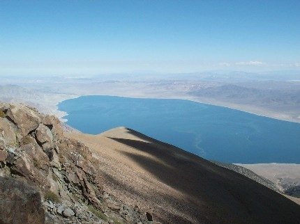
Mineral County was carved out of Esmeralda County in 1911 shortly after the county seat of Esmeralda was moved to Goldfield in 1907. Its name came from the surrounding area, which is heavily mineralized. Hawthorne has always been its county seat. The county is listed as Nevada Historical Marker 16. The marker is located on U.S. Highway 95 at Walker Lake.
Geography
According to the U.S. Census Bureau, the county has a total area of 3813 sqmi, of which 3753 sqmi is land and 60 sqmi (1.6%) is water. The highest point in Mineral County is Mount Grant at 11,285 ft.
Major highways
- [[File:I-11 (Future).svg|20px]] Interstate 11 (Future)
- [[File:US 6.svg|20px]] U.S. Route 6
- [[File:US 95.svg|20px]] U.S. Route 95
- [[File:Alt plate.svg|20px]]
- [[File:Truck plate.svg|20px]]
- [[File:Nevada 359.svg|20px]] State Route 359
- [[File:Nevada 360.svg|20px]] State Route 360
- [[File:Nevada 361.svg|20px]] State Route 361
Adjacent counties
- Lyon County - northwest
- Churchill County - north
- Nye County - northeast
- Esmeralda County - southeast
- Mono County, California - southwest
National protected areas
- Inyo National Forest (part)
- Toiyabe National Forest (part)
Demographics
|align-fn=center 1790-1960 1900-1990 1990-2000 2010-2020
2020 census
As of the 2020 census, the county had a population of 4,554. The median age was 47.3 years. 20.3% of residents were under the age of 18 and 25.4% of residents were 65 years of age or older. For every 100 females there were 100.6 males, and for every 100 females age 18 and over there were 98.5 males age 18 and over.
0.0% of residents lived in urban areas, while 100.0% lived in rural areas.
The racial makeup of the county was 65.9% White, 3.6% Black or African American, 17.2% American Indian and Alaska Native, 1.4% Asian, 0.2% Native Hawaiian and Pacific Islander, 3.7% from some other race, and 7.9% from two or more races. Hispanic or Latino residents of any race comprised 11.2% of the population.
There were 2,102 households in the county, of which 25.4% had children under the age of 18 living with them and 29.8% had a female householder with no spouse or partner present. About 36.7% of all households were made up of individuals and 17.3% had someone living alone who was 65 years of age or older.
There were 2,586 housing units, of which 18.7% were vacant. Among occupied housing units, 65.8% were owner-occupied and 34.2% were renter-occupied. The homeowner vacancy rate was 2.6% and the rental vacancy rate was 10.1%.
2010 census
At the 2010 census, there were 4,772 people, 2,240 households, and 1,258 families living in the county.{{cite web |access-date=January 21, 2016 |archive-url=https://archive.today/20200213011141/http://factfinder.census.gov/bkmk/table/1.0/en/DEC/10_DP/DPDP1/0500000US32021 |archive-date=February 13, 2020 |url-status=dead |access-date=January 21, 2016 |archive-url=https://archive.today/20200213162221/http://factfinder.census.gov/bkmk/table/1.0/en/DEC/10_SF1/GCTPH1.CY07/0500000US32021 |archive-date=February 13, 2020 |url-status=dead |access-date=January 21, 2016 |archive-url=https://archive.today/20200213021942/http://factfinder.census.gov/bkmk/table/1.0/en/ACS/10_5YR/DP02/0500000US32021 |archive-date=February 13, 2020 |url-status=dead
Of the 2,240 households, 21.2% had children under the age of 18 living with them, 39.0% were married couples living together, 11.2% had a female householder with no husband present, 43.8% were non-families, and 36.7% of households were made up of individuals. The average household size was 2.11 and the average family size was 2.70. The median age was 49.2 years.
The median household income was $35,446 and the median family income was $57,064. Males had a median income of $48,281 versus $33,830 for females. The per capita income for the county was $23,226. About 11.4% of families and 19.1% of the population were below the poverty line, including 11.0% of those under age 18 and 12.6% of those age 65 or over.{{cite web |access-date=January 21, 2016 |archive-url=https://archive.today/20200213015119/http://factfinder.census.gov/bkmk/table/1.0/en/ACS/10_5YR/DP03/0500000US32021 |archive-date=February 13, 2020 |url-status=dead
2000 census
At the 2000 census there were 5,071 people, 2,197 households, and 1,379 families living in the county. The population density was 1 /mi2. There were 2,866 housing units at an average density of 1 /mi2. The racial makeup of the county was 73.9% White, 4.8% Black or African American, 15.5% Native American, 0.8% Asian, 0.1% Pacific Islander, 2.7% from other races, and 2.4% from two or more races. 8.44% of the population were Hispanic or Latino of any race. Of the 2,197 households 25.40% had children under the age of 18 living with them, 45.20% were married couples living together, 11.50% had a female householder with no husband present, and 37.20% were non-families. 31.60% of households were one person and 15.10% were one person aged 65 or older. The average household size was 2.26 and the average family size was 2.78.
The age distribution was 24.40% under the age of 18, 6.20% from 18 to 24, 22.50% from 25 to 44, 27.10% from 45 to 64, and 19.80% 65 or older. The median age was 43 years. For every 100 females, there were 101.60 males. For every 100 females age 18 and over, there were 98.30 males.
The median household income was $32,891 and the median family income was $39,477. Males had a median income of $31,929 versus $25,262 for females. The per capita income for the county was $16,952. About 11.00% of families and 15.20% of the population were below the poverty line, including 17.70% of those under age 18 and 10.70% of those age 65 or over.
Communities

There are no incorporated communities in Mineral County.
Census-designated places
- Hawthorne (county seat)
- Mina
- Schurz
- Walker Lake
Unincorporated communities
- Luning
Other places
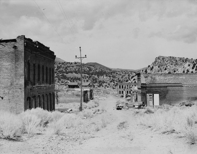
- Aurora
- Babbitt
- Basalt
- Belleville
- Broken Hills
- Candelaria
- Eagleville
- Kinkaid
- Lucky Boy
- Marietta
- Montgomery Pass
- Omco
- Rand
- Rawhide
- Rhodes
- Sodaville
- Thorne
Politics
For much of the 20th Century, Mineral County leaned Democratic and only voted Republican in national landslides. During the Reagan era, the county flipped decisively into the Republican column. The only Democrat to carry the county after 1976 was Bill Clinton in 1996 as a result of high third-party performance, although Barack Obama came within just over 2 points of winning it in 2008. Since this year, the county's Republican tilt has increased in every election.
References
References
- "State & County QuickFacts". United States Census Bureau.
- "County Explorer". National Association of Counties.
- "Nevada Historical Markers". Nevada State Historic Preservation Office.
- (August 22, 2012). "2010 Census Gazetteer Files". United States Census Bureau.
- "County Population Totals and Components of Change: 2020-2024". United States Census Bureau.
- "U.S. Decennial Census". United States Census Bureau.
- "Historical Census Browser". University of Virginia Library.
- "Population of Counties by Decennial Census: 1900 to 1990". United States Census Bureau.
- "Census 2000 PHC-T-4. Ranking Tables for Counties: 1990 and 2000". United States Census Bureau.
- (2023). "2020 Decennial Census Demographic and Housing Characteristics (DHC)".
- (2021). "2020 Decennial Census Redistricting Data (Public Law 94-171)".
- (2021). "2020 Decennial Census Demographic Profile (DP1)".
- "U.S. Census website". [[United States Census Bureau]].
- Leip, David. "Dave Leip's Atlas of U.S. Presidential Elections".
- The leading "other" candidate, [[Progressive Party (United States, 1912). Progressive]] [[Theodore Roosevelt]], received 146 votes, while Socialist candidate [[Eugene V. Debs. Eugene Debs]] received 131 votes.
- (November 5, 2024). "2024 Senate Election (Official Returns)".
This article was imported from Wikipedia and is available under the Creative Commons Attribution-ShareAlike 4.0 License. Content has been adapted to SurfDoc format. Original contributors can be found on the article history page.
Ask Mako anything about Mineral County, Nevada — get instant answers, deeper analysis, and related topics.
Research with MakoFree with your Surf account
Create a free account to save articles, ask Mako questions, and organize your research.
Sign up freeThis content may have been generated or modified by AI. CloudSurf Software LLC is not responsible for the accuracy, completeness, or reliability of AI-generated content. Always verify important information from primary sources.
Report