From Surf Wiki (app.surf) — the open knowledge base
Milwaukee metropolitan area
Metropolitan area in Wisconsin, United States
Metropolitan area in Wisconsin, United States
| Field | Value | |||||||
|---|---|---|---|---|---|---|---|---|
| name | Milwaukee Metropolitan Area | |||||||
| official_name | Milwaukee–Racine–Waukesha, WI | |||||||
| Combined Statistical Area | ||||||||
| settlement_type | Combined Statistical Area | |||||||
| image_skyline | Dji fly 20241201 160430 0031 1733092392756 photo-edit1.jpg | |||||||
| image_size | 300px | |||||||
| image_caption | Downtown Milwaukee | |||||||
| image_map | {{maplink | frame=yes | plain=yes | frame-align=center | frame-width=290 | frame-height=240 | zoom=7 | frame-coord= |
| type1 | shape | id1=Q502294 | title1=Milwaukee County | stroke-color1=#720000 | stroke-width1=0.5 | fill1=#720000 | fill-opacity1=0.4 | |
| type2 | shape | id2=Q505874 | title2=Ozaukee County | stroke-color2=#720000 | stroke-width2=0.5 | fill2=#720000 | fill-opacity2=0.4 | |
| type3 | shape | id3=Q501559 | title3=Washington County | stroke-color3=#720000 | stroke-width3=0.5 | fill3=#720000 | fill-opacity3=0.4 | |
| type4 | shape | id4=Q370654 | title4=Waukesha County | stroke-color4=#720000 | stroke-width4=0.5 | fill4=#720000 | fill-opacity4=0.4 | |
| type5 | shape | id5=Q510122 | title5=Racine County | stroke-color5=#FF9200 | stroke-width5=0.5 | fill5=#FF9200 | fill-opacity5=0.4 | |
| type6 | shape | id6=Q202454 | title6=Walworth County | stroke-color6=#BD00C8 | stroke-width6=0.5 | fill6=#BD00C8 | fill-opacity6=0.4 | |
| type7 | shape | id7=Q372796 | title7=Dodge County | stroke-color7=#0000FF | stroke-width7=0.5 | fill7=#0000FF | fill-opacity7=0.4 | |
| type8 | shape | id8=Q500958 | title8=Jefferson County | stroke-color8=#00BCE4 | stroke-width8=0.5 | fill8=#00BCE4 | fill-opacity8=0.4 | |
| type9 | shape | id9=Q37836 | title9=City of Milwaukee | stroke-color9=#007272 | stroke-width9=0.5 | fill9=#007272 | fill-opacity9=0.6 | |
| map_alt | Map of Greater Milwaukee | |||||||
| map_caption | Map of Milwaukee–Racine–Waukesha, WI CSA | |||||||
| coordinates | ||||||||
| subdivision_type | Country | |||||||
| subdivision_name | [[File:Flag of United States.svg | border | 23px]] United States | |||||
| subdivision_type1 | State | |||||||
| subdivision_name1 | Wisconsin | |||||||
| subdivision_type2 | Largest city | |||||||
| subdivision_name2 | Milwaukee | |||||||
| subdivision_type3 | Other cities | |||||||
| subdivision_name3 | {{Plainlist | - Waukesha | ||||||
| - West Allis | ||||||||
| - Racine | ||||||||
| - Whitewater | ||||||||
| - Elkhorn | ||||||||
| - Lake Geneva | ||||||||
| - Beaver Dam | ||||||||
| - Watertown | ||||||||
| - Fort Atkinson | ||||||||
| - Mequon | ||||||||
| unit_pref | US | |||||||
| area_total_sq_mi | 3356 | |||||||
| elevation_max_footnotes | tags -- | |||||||
| elevation_min_footnotes | tags -- | |||||||
| population_as_of | 2010 | |||||||
| population_footnotes | ||||||||
| population_total | 1,555,908 | |||||||
| population_density_sq_mi | 464 | |||||||
| demographics_type2 | GDP | |||||||
| demographics2_footnotes | ||||||||
| demographics2_title1 | Total | |||||||
| demographics2_info1 | $130.857 billion (2023) | |||||||
| timezone | CST | |||||||
| utc_offset | −6 | |||||||
| timezone_DST | CDT | |||||||
| utc_offset_DST | −5 |
Combined Statistical Area
- West Allis
- Racine
- Whitewater
- Elkhorn
- Lake Geneva
- Beaver Dam
- Watertown
- Fort Atkinson
- Mequon
The Milwaukee metropolitan area (also known as Metro Milwaukee or Greater Milwaukee) is a major metropolitan area located in Southeastern Wisconsin, consisting of the city of Milwaukee and some of the surrounding area. There are several definitions of the area, including the Milwaukee–Waukesha–West Allis metropolitan area and the Milwaukee–Racine–Waukesha combined statistical area. It is the largest metropolitan area in Wisconsin with an estimated population of about 1.6 million people ranking it as the 39th largest metropolitan area (4 County area) in United States, and the 34th largest combined statistical area (8 County area) in the U.S. the with a 2024 population estimate of 2,054,012.
Definitions
Metropolitan area
1790–1960 1900–1990 1990–2000 2010–2014
The U.S. Census Bureau defines the Milwaukee Metropolitan area as containing four counties in southeastern Wisconsin: Milwaukee and the three WOW counties: Ozaukee, Washington, and Waukesha. The Metropolitan population of Milwaukee was 1,575,179 in the Census Bureau's 2019 estimate, making it the 39th largest in the United States.
The city of Milwaukee is the hub of the metropolitan area. The eastern parts of Racine County, eastern parts of Waukesha County, southern part of Ozaukee County, southeastern part of Washington County, and remainder of Milwaukee County are the most urbanized parts of the outlying counties.
The character of the area varies widely. Mequon, Brookfield, and the North Shore (Fox Point, Whitefish Bay, River Hills, Shorewood, Glendale, Brown Deer, and Bayside) are more white-collar, while West Milwaukee, West Allis, and St. Francis are more blue-collar.
Metro Milwaukee draws commuters from outlying areas such as Madison, Chicago and the Fox Cities. It is part of the Great Lakes Megalopolis containing an estimated 54 million people.
Combined statistical area
The Milwaukee–Racine–Waukesha Combined Statistical Area is made up of the Milwaukee–Waukesha–West Allis Metropolitan Statistical Area (Milwaukee, Waukesha, Washington and Ozaukee counties), the Racine Metropolitan Statistical Area (Racine County), the Beaver Dam Micropolitan Statistical Area (Dodge County), the Watertown-Fort Atkinson Micropolitan Area (Jefferson County), and the Whitewater-Elkorn Micropolitan Area (Walworth County) according to the U.S. Census. Updated definitions released in February 2013 added Dodge, Jefferson and Walworth Counties to the Milwaukee CSA. Kenosha, despite being just 32 miles from Milwaukee and 50 miles from Chicago, is included as part of the Chicago CSA, as Kenosha has more residents who commute to the Chicago area. As of the 2019 census estimates, the Milwaukee–Racine–Waukesha Combined Statistical Area population was 2,047,966, the largest in Wisconsin and the 33rd largest in the United States. The Milwaukee-Racine-Waukesha CSA shares an eastern border with the Madison MSA the Janesville-Beloit MSA which in turn are both a part of the Madison CSA.
Counties
There are eight counties in the U.S. Census Bureau's Milwaukee–Racine–Waukesha Combined statistical area.https://www.census.gov/population/estimates/metro_general/List1.txt
- Dodge
- Jefferson
- Milwaukee
- Ozaukee
- Racine
- Walworth
- Washington
- Waukesha
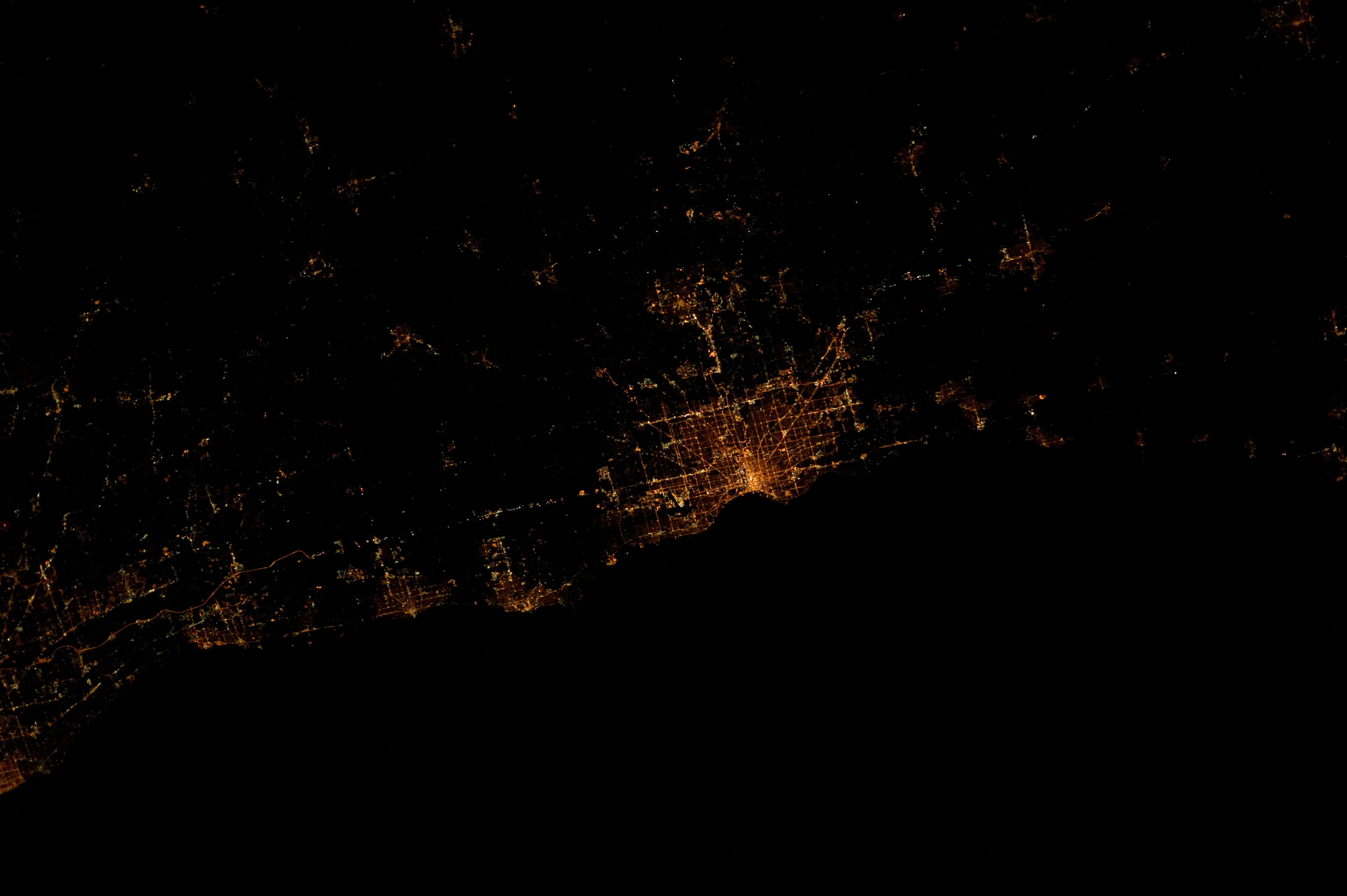
To the left of Milwaukee along the lakeshore are the cities of Racine, Kenosha, and Waukegan. Kenosha and Waukegan are considered part of the Chicago CSA rather than part of metro Milwaukee. The lights in the far left along the lake are from a portion of Cook County, of which Chicago is the county seat.
To the right of Milwaukee are Cedarburg and Grafton. Port Washington is just to the right of Grafton and along the lakeshore. Above Port Washington, the "+" shaped lights are from West Bend. In the far right edge, a small portion of Sheboygan can be seen along the lakeshore.]]
Cities (combined statistical area)

Primary
- Milwaukee
Other principal cities
- Racine
- Waukesha
Metro area cities and villages with more than 10,000 inhabitants
- Beaver Dam
- Brookfield
- Brown Deer
- Burlington
- Caledonia
- Cedarburg
- Cudahy
- Delavan
- Elkhorn
- Fort Atkinson
- Franklin
- Germantown
- Glendale
- Grafton
- Greendale
- Greenfield
- Hartford
- Menomonee Falls
- Mequon
- Mount Pleasant
- Muskego
- New Berlin
- Oak Creek
- Oconomowoc
- Pewaukee
- Port Washington
- Richfield
- Shorewood
- South Milwaukee
- Sussex
- Watertown
- Wauwatosa
- West Allis
- West Bend
- Whitefish Bay
- Whitewater
Metro area cities, towns and villages with fewer than 10,000 inhabitants
- Addison
- Barton
- Bayside
- Belgium
- Big Bend
- Bohners Lake
- Brookfield (town)
- Browns Lake
- Brownsville
- Butler
- Cambridge (part)
- Chenequa
- Clyman
- Columbus (part)
- Darien
- Delafield (city)
- Delafield (town)
- Dousman
- Dover
- Eagle
- Eagle Lake
- East Troy
- Elkhorn
- Elm Grove
- Elmwood Park
- Erin
- Farmington
- Fox Lake
- Fox Point
- Franksville
- Fredonia
- Genesee
- Germantown (town)
- Hales Corners
- Hartland
- Herman
- Horicon
- Hustisford
- Ixonia
- Iron Ridge
- Jackson
- Jefferson
- Johnson Creek
- Juneau
- Kekoskee
- Kewaskum
- Lac La Belle
- Lake Geneva
- Lake Mills
- Lannon
- Leroy
- Lisbon
- Lomira
- Lowell
- Mayville
- Merton
- Mukwonago
- Nashotah
- Neosho
- Newburg
- North Bay
- North Prairie
- Norway
- Oconomowoc Lake
- Okauchee Lake
- Ottawa
- Palmyra
- Pewaukee(village)
- Polk
- Randolph
- Raymond
- Reeseville
- River Hills
- Rochester
- Rubicon
- Saukville
- Sharon
- Slinger
- St. Francis
- Sturtevant
- Sullivan
- Summit
- Theresa
- Thiensville
- Trenton
- Union Grove
- Vernon
- Wales
- Walworth
- Waterford
- Waterloo
- Waupun (part)
- Wayne
- West Milwaukee
- Williams Bay
- Wind Lake
- Wind Point
- Yorkville
Unincorporated Communities and Census Designated Places
- Allenton
- Boltonville
- Cheeseville
- Colgate
- Ebenezer
- Farmersville
- Fillmore
- Genesee Depot
- Herman Center
- Hubertus
- Kansasville
- Kohlsville
- Lake Church
- Lakefield
- Myra
- Nabob
- Nenno
- North Cape
- Oak Hill
- Pipersville
- Pike Lake
- Rockfield
- Saint Michaels
- Saylesville
- Saylesville
- Stone Bank
- Thompson
- Tichigan
- Ulao
- Waubeka
- Woodland
Politics
The city of Milwaukee is overwhelmingly Democratic, while suburban Milwaukee County was historically politically divided, but has shifted to the left in recent election cycles. The WOW counties have long been a Republican stronghold for decades, but they have been trending to the left in recent elections. Dodge County, Jefferson County, Walworth County, and Racine County, which are located on the outskirts of the metro lean Republican.
Debate over metropolitan government
Although each county and its various municipalities are self-governing, there is some cooperation in the metropolitan area. The Milwaukee Metropolitan Sewerage District (MMSD) is a state-chartered government agency which serves 28 municipalities in the five counties.
At the same time, some in the area see the need for more consolidation in government services. The Kettl Commission and former Wisconsin Governor Scott McCallum have supported initiatives to do this. However, full consolidation has faced unsubstantiated criticism as a means of diluting minority voting power.
References
References
- "2010 Census Data - 2010 Census".
- "Total Gross Domestic Product for Milwaukee-Waukesha-West Allis, WI (MSA)". [[Federal Reserve Bank of St. Louis]].
- "U.S. Decennial Census". United States Census Bureau.
- "Historical Census Browser". University of Virginia Library.
- (March 27, 1995). "Population of Counties by Decennial Census: 1900 to 1990". United States Census Bureau.
- (April 2, 2001). "Census 2000 PHC-T-4. Ranking Tables for Counties: 1990 and 2000". United States Census Bureau.
- "United States 2020 Decennial Census".
- (March 26, 2020). "Metropolitan and Micropolitan Statistical Areas Population Totals and Components of Change: 2010-2019". [[United States Census Bureau]], Population Division.
- "Archived copy". [[Office of Management and Budget]].
- "Suburban Milwaukee County".
- "Milwaukee Metro Presidential Results".
- "State Canvasses".
This article was imported from Wikipedia and is available under the Creative Commons Attribution-ShareAlike 4.0 License. Content has been adapted to SurfDoc format. Original contributors can be found on the article history page.
Ask Mako anything about Milwaukee metropolitan area — get instant answers, deeper analysis, and related topics.
Research with MakoFree with your Surf account
Create a free account to save articles, ask Mako questions, and organize your research.
Sign up freeThis content may have been generated or modified by AI. CloudSurf Software LLC is not responsible for the accuracy, completeness, or reliability of AI-generated content. Always verify important information from primary sources.
Report