From Surf Wiki (app.surf) — the open knowledge base
Mills County, Iowa
County in Iowa, United States

County in Iowa, United States
| Field | Value |
|---|---|
| county | Mills County |
| state | Iowa |
| ex image | Mills County IA Courthouse.jpg |
| ex image cap | Mills County Courthouse |
| founded year | 1851 |
| seat wl | Glenwood |
| largest city wl | Glenwood |
| area_total_sq_mi | 441 |
| area_land_sq_mi | 437 |
| area_water_sq_mi | 3.2 |
| area percentage | 0.7 |
| population_as_of | 2020 |
| population_total | 14484 |
| population_density_sq_mi | auto |
| pop_est_as_of | 2024 |
| population_est | 14717 |
| time zone | Central |
| web | https://www.millscountyiowa.gov/ |
| district | 3rd |
Mills County is a county located in the U.S. state of Iowa. As of the 2020 census, the population was 14,484. The county seat is Glenwood. The county was formed in 1851 and named for Major Frederick Mills of Burlington, Iowa, who was killed at the Battle of Churubusco during the Mexican–American War.
Mills County is included in the Omaha–Council Bluffs metropolitan area.
History
The future county's first permanent settlement was Rushville, founded in 1846 by persecuted members of the Church of Jesus Christ of Latter-day Saints as they were being driven out of Nauvoo, Illinois. This is not to be confused with the state's present-day Rushville in Jasper County. A nearby settlement, also founded by the Mormon settlers, was called Coonsville after Dr. Liberius Coons, one of the first arrivals. That settlement continued after the Mormons moved on; its name was changed to Glenwood in 1853.
In Glenwood, the first courthouse was a small frame building which served until 1857. It was replaced by a two-story building, which was enlarged in the 1900s and received a clock tower in 1910. In 1959 this building was replaced with the present building, dedicated on August 29, 1959.
Geography
According to the U.S. Census Bureau, the county has a total area of 441 sqmi, of which 437 sqmi is land and 3.2 sqmi (0.7%) is water.
Major highways
- [[File:I-29.svg|x20px]] Interstate 29
- [[File:US 34.svg|x20px]] U.S. Highway 34
- [[File:US 59.svg|x20px]] U.S. Highway 59
- [[File:US 275.svg|x20px]] U.S. Highway 275
Adjacent counties
- Pottawattamie County, Iowa(north)
- Montgomery County, Iowa (east)
- Fremont County, Iowa (south)
- Cass County, Nebraska (southwest)
- Sarpy County, Nebraska (west)
Demographics
|align-fn=center 1790-1960 1900-1990 1990-2000 2010-2018
2020 census
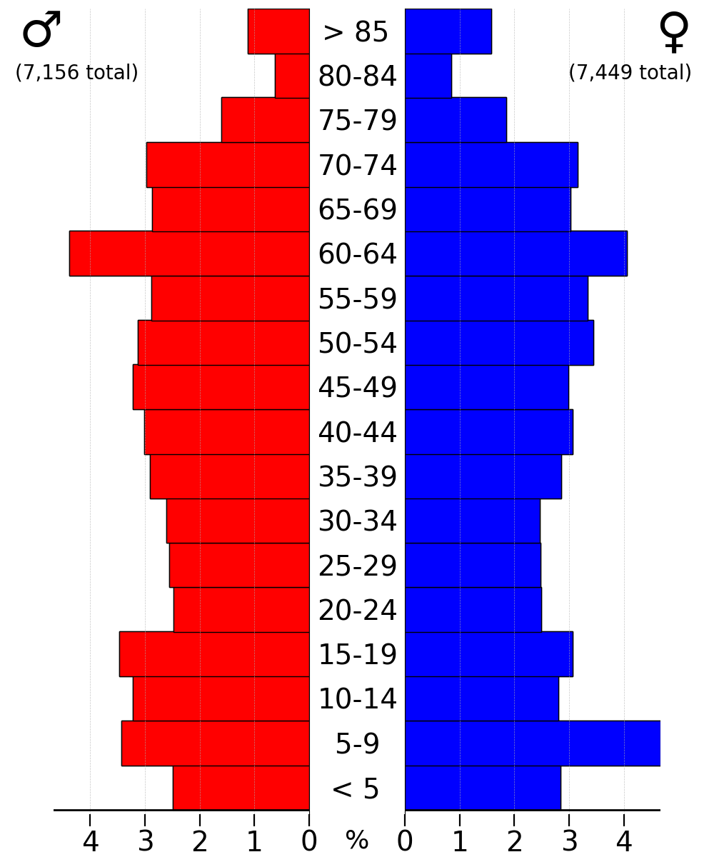
As of the 2020 census, the county had a population of 14,484 and a population density of .
The median age was 43.1 years. 24.6% of residents were under the age of 18 and 19.2% of residents were 65 years of age or older. For every 100 females there were 99.6 males, and for every 100 females age 18 and over there were 97.8 males age 18 and over.
According to the 2020 Decennial Census Redistricting Data, 95.16% of the population reported being of one race while 5.63% reported being some other race or more than one race. Of the single-race responses, 90.05% were non-Hispanic White, 0.53% were Black or African American, 0.21% were Native American, 0.33% were Asian, and 0.07% were Native Hawaiian or Pacific Islander. Including multiple-race and other-race residents, the total composition was 93.2% White, 0.5% Black or African American, 0.2% American Indian and Alaska Native, 0.3% Asian, 0.1% Native Hawaiian and Pacific Islander, 0.8% from some other race, and 4.8% from two or more races; Hispanic or Latino residents of any race comprised 3.2% of the population.
34.6% of residents lived in urban areas, while 65.4% lived in rural areas.
There were 5,512 households in the county, of which 32.1% had children under the age of 18 living in them. Of all households, 58.3% were married-couple households, 15.3% were households with a male householder and no spouse or partner present, and 20.7% were households with a female householder and no spouse or partner present. About 23.4% of all households were made up of individuals and 11.5% had someone living alone who was 65 years of age or older. Of the county's 6,110 housing units, 5,512 were occupied (9.8% vacant). Among occupied housing units, 80.6% were owner-occupied and 19.4% were renter-occupied. The homeowner vacancy rate was 1.7% and the rental vacancy rate was 8.6%.
2010 census
The 2010 census recorded a population of 15,059 in the county, with a population density of . There were 6,109 housing units, of which 5,605 were occupied.
2000 census
As of the census of 2000, there were 14,547 people, 5,324 households, and 3,939 families residing in the county. The population density was 33 /mi2. There were 5,671 housing units at an average density of 13 /mi2. The racial makeup of the county was 97.97% White, 0.28% Black or African American, 0.27% Native American, 0.29% Asian, 0.01% Pacific Islander, 0.36% from other races, and 0.82% from two or more races. 1.23% of the population were Hispanic or Latino of any race.
There were 5,324 households, out of which 34.80% had children under the age of 18 living with them, 61.70% were married couples living together, 8.90% had a female householder with no husband present, and 26.00% were non-families. 22.30% of all households were made up of individuals, and 10.10% had someone living alone who was 65 years of age or older. The average household size was 2.60 and the average family size was 3.04.
In the county, the population was spread out, with 26.80% under the age of 18, 7.00% from 18 to 24, 28.10% from 25 to 44, 25.50% from 45 to 64, and 12.60% who were 65 years of age or older. The median age was 38 years. For every 100 females there were 100.60 males. For every 100 females age 18 and over, there were 96.70 males.
The median income for a household in the county was $42,428, and the median income for a family was $49,592. Males had a median income of $31,721 versus $24,938 for females. The per capita income for the county was $18,736. About 5.80% of families and 8.30% of the population were below the poverty line, including 10.30% of those under age 18 and 7.60% of those age 65 or over.
Communities

Cities
- Emerson
- Glenwood
- Hastings
- Henderson
- Malvern
- Pacific Junction
- Silver City
- Tabor (partial)
Unincorporated communities
- Balfour
- Rushville
- Strahan
Census-designated place
- Mineola
Townships
- Anderson
- Center
- Deer Creek
- Glenwood
- Indian Creek
- Ingraham
- Lyons
- Oak
- Plattville
- Rawles
- St. Marys
- Silver Creek
- White Cloud
Population ranking
The population ranking of the following table is based on the 2020 census of Mills County.
† county seat
| Rank | City/town/etc. | Municipal type | Population (2020 Census) |
|---|---|---|---|
| 1 | † Glenwood | City | 5,073 |
| 2 | Malvern | City | 1,046 |
| 3 | Emerson | City | 403 |
| 4 | Silver City | City | 245 |
| 5 | Mineola | CDP | 154 |
| 6 | Hastings | City | 152 |
| 7 | Henderson | City | 144 |
| 8 | Pacific Junction | City | 96 |
| 9 | Tabor (mostly in Fremont County) | City | 86 (1,014 total) |
Law enforcement
The first Mills County Sheriff was W.W. Noyes who was appointed by the Iowa General Assembly on August 1, 1851. He was succeeded by James Hardy who served as the first elected sheriff of the county and assumed the office on August 31, 1851.
The current sheriff of Mills County is interim sheriff Joshua England. He and his 11 full-time deputies patrol approximately 447 square miles in the county. The Mills County Sheriff's Office provides police services under contract for all of the towns and cities and Mills County except for the City of Glenwood which has its own police department.
Politics
Mills County is one of the most consistently Republican counties in Iowa. It has backed the Republican in all but five elections in its history, its inaugural election in 1852 prior to the founding of the Republican Party, in 1912 when former Republican turned Progressive Theodore Roosevelt caused a split in the vote, allowing Democrat Woodrow Wilson to take the county with a sub-40% plurality, in the two landslide victories for Franklin D. Roosevelt in 1932 and 1936, and for Lyndon B. Johnson in his 1964 landslide, who even then barely took Mills County by only 39 votes and less than 1%.
Local government
Board of supervisors
The board of supervisors is elected according to Plan One of the 1984 Code of Iowa, Chapter 331.208. It is composed of three members elected at large. Vacancies in the board of supervisors are filled by appointment made by the county auditor, county recorder, and the clerk of district court.
Current board of supervisors
- Richard Crouch, board chair
- Term expires 2026
- Carol Vinton, vice chair
- Term expires 2024
- Lonnie Mayberry, board member
- Term expires 2024
2024 election
There are two open seats on the Mills County Board of Supervisors that will be elected in the November 2024 General Election. Primary Vote Count
| Name | Party affiliation | Primary votes |
|---|---|---|
| Jack A. Sayers | Republican | 890 |
| Lonnie Mayberry | Republican | 777 |
| Bruce Wray | Democrat | 30 |
County attorney
DeShawne Bird-Sell is the current Mills County, IA county attorney. Their term ends in 2026.
County auditor
Ami Petersen is the current Mills County, IA county auditor. Their term ends in 2024
2024 election
| Name | Party affiliation | Primary votes |
|---|---|---|
| Amber Farnan | Republican | 814 |
County recorder
Lu Anne Christiansen is the current Mills County, IA county reporter. Their term ends in 2026.
County sheriff
Josh England is the current Mills County, IA sheriff. Their term ends in 2024.
2024 election
| Name | Party affiliation | Primary votes |
|---|---|---|
| Greg Schultz | Republican | 1,345 |
County treasurer
Jill Ford is the current Mills County, IA county treasurer. Their term ends in 2026.
References
References
- "2020 Census State Redistricting Data". United states Census Bureau.
- "Find a County". National Association of Counties.
- [http://www.iowacounties.org/About%20Us/AboutCoGov/County%20Pages/Mills.htm Mills County]{{dead link. (January 2018)
- United States Office of Management and Budget. "Update of Statistical Area Definitions and Guidance on Their Uses".
- ""History" - Mills County".
- (February 12, 2011). "US Gazetteer files: 2010, 2000, and 1990". United States Census Bureau.
- "Population and Housing Unit Estimates Tables". United States Census Bureau.
- "U.S. Decennial Census". United States Census Bureau.
- "Historical Census Browser". University of Virginia Library.
- "Population of Counties by Decennial Census: 1900 to 1990". United States Census Bureau.
- "Census 2000 PHC-T-4. Ranking Tables for Counties: 1990 and 2000". United States Census Bureau.
- "State & County QuickFacts". United States Census Bureau.
- (2021). "2020 Decennial Census Demographic Profile (DP1)".
- (2021). "2020 Decennial Census Redistricting Data (Public Law 94-171)".
- (2023). "2020 Decennial Census Demographic and Housing Characteristics (DHC)".
- "Population & Housing Occupancy Status 2010". United States Census Bureau – American FactFinder.
- "U.S. Census website". United States Census Bureau.
- [http://www.millscoia.us/offices/sheriff/sheriffhistory.htm History of Mills County Sheriff's Office] {{webarchive. link. (October 15, 2011)
- Leip, David. "Dave Leip's Atlas of U.S. Presidential Elections".
- "Election Night Reporting".
This article was imported from Wikipedia and is available under the Creative Commons Attribution-ShareAlike 4.0 License. Content has been adapted to SurfDoc format. Original contributors can be found on the article history page.
Ask Mako anything about Mills County, Iowa — get instant answers, deeper analysis, and related topics.
Research with MakoFree with your Surf account
Create a free account to save articles, ask Mako questions, and organize your research.
Sign up freeThis content may have been generated or modified by AI. CloudSurf Software LLC is not responsible for the accuracy, completeness, or reliability of AI-generated content. Always verify important information from primary sources.
Report