From Surf Wiki (app.surf) — the open knowledge base
Milestone
Numbered marker along a road or boundary

Numbered marker along a road or boundary

A milestone is a numbered marker placed on a route such as a road, railway line, canal or boundary. They can indicate the distance to towns, cities, and other places or landmarks like mileage signs; or they can give their position on the route relative to some datum location (a zero milepost). On roads they are typically located at the side or in a median or central reservation. They are alternatively known as mile markers (sometimes abbreviated MMs), mileposts or mile posts (sometimes abbreviated MPs). A "kilometric point" is a term used in metricated areas, where distances are commonly measured in kilometres instead of miles. "Distance marker" is a generic unit-agnostic term.
Milestones are installed to provide linear referencing points along the road. This can be used to reassure travellers that the proper path is being followed, and to indicate either distance travelled or the remaining distance to a destination. Such references are also used by maintenance engineers and emergency services to direct them to specific points where their presence is required. This term is sometimes used to denote a location on a road even if no physical sign is present. This is useful for accident reporting and other record keeping (e.g., "an accident occurred at the 13-mile mark" even if the road is only marked with a stone once every 10 miles). Distance markers are typically written only to integer values (sometimes with a single significant figures), often with the unit name or symbol before the number, as in "mile x" or "kilometre y", for example, "mile 317" or "kilometre 510".
History
Roman Empire
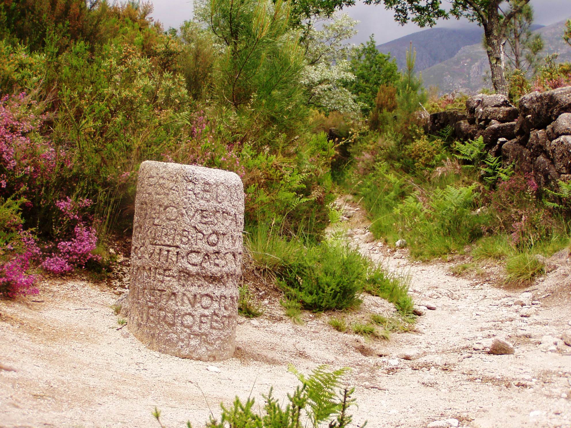

Miliarium () were originally stone obelisks – made from granite, marble, or whatever local stone was available – and later concrete posts. They were widely used by Roman Empire road builders and were an important part of any Roman road network: the distance travelled per day was only a few miles in some cases. Many Roman milestones only record the name of the reigning emperor without giving any placenames or distances. The first Roman milestones appeared on the Appian Way. At the centre of Rome, the "Golden Milestone" was erected to mark the presumed centre of the empire: this milestone has since been lost. The Golden Milestone inspired the Zero Milestone in Washington, D.C., intended as the point from which all road distances in the United States should be reckoned. Odometers were used to measure the Roman milestone spacing, most likely based on Ancient Greek technology.
Byzantine Empire
A mile-marker monument, the Milion, was erected in the early 4th century AD in Constantinople. It served as the starting point for measurement of distances for all the roads leading to the cities of the Byzantine Empire, and had the same function as the Milliarium Aureum of Ancient Rome. The Milion survived intact until at least the late 15th century. Its fragments were discovered again in the late 1960s. A fragment is re-erected as a pillar.
Islamic civilization
In Islamic civilisation, use of milestone began in the first Islamic century. The Umayyad caliph Abd al-Malik bin Marwan laid the milestones along the paths that travelers used, and some were found in the city of Faiq in the Syrian Golan, which is, Faiq, one of the main road stations throughout the Islamic ages. The function of these stones was to guide travelers and introduce them to long distances, as the separation between one and the other was one mile. Many of these stones were found in more than one location, one in the Islamic Archeology Museum in Istanbul and another in the Jerusalem Museum. A translation of the text written on the stone currently found in the Kasserine Museum in the Golan reads as follows:
In the name of God, the Most Gracious, the Most Merciful.
There is no god but God alone, and there is no partner for it. Muhammad is the Messenger of God. He ordered the making of these miles, Abdul Malik bin Marwan, Commander of the Faithful. At the hands of a consultant, the Lord of the Faithful. In Sha'ban from the year eighty-five, from Damascus to this stone fifty-three miles.}}
Post-Medieval Europe

In Europe, the distance measured typically starts at specified point within a city or town, as many roads were named for the towns at either end. For example, in London, United Kingdom, a plaque near the Eleanor cross at Charing Cross is the reference point from which distances from London to other towns and cities are measured. In the UK, milestones are especially associated with former turnpike roads.
The British built many milestones on the island of Malta. They consisted of large slabs of local hard rock and they were engraved with the distance to or from a particular location. Many of these were defaced in World War II to disorientate forces in a potential invasion. Despite this, a very small number of milestones still exist undefaced, and one of these is now in the Malta at War Museum.
India
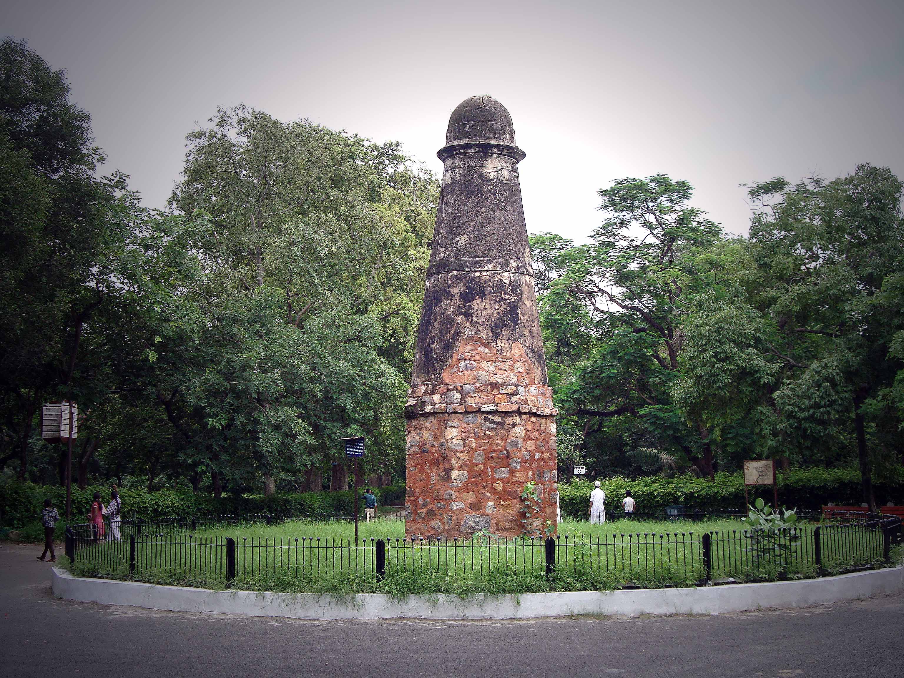
The Kos Minars or Mile Pillars are medieval milestones that were made by the 16th-century Afghan Ruler Sher Shah Suri and later on by Mughal emperors. These Minars were erected by the Mughal Emperors on the main highways across the empire to mark the distance. The Kos Minar is a solid round pillar, around 30 ft in height that stands on a masonry platform built with bricks and plastered over with lime. Though not architecturally very impressive, being milestones, they were an important part of communication and travel in a large empire.
Kos is an ancient Indian unit of distance. It can represent either a distance of approximately 1.8 km or 3.2 km. Minar is a Persian word for tower. Abul Fazl recorded in Akbar Nama that in the year 1575 AD, Akbar issued an order that at every Kos on the way from Agra to Ajmer, a pillar or a minar should be erected for the comfort of the travelers.
Modern highways
Main article: Highway location marker

The historical term milestone is still used today, even though the "stones" are typically metal highway location markers and in most countries use kilometres and metres rather than miles and yards. Also found today are more closely spaced signs containing fractional numbers, and signs along railways, beaches and canals.
Railway mileposts

The Railways Clauses Consolidation Act 1845{{cite web | access-date = 2008-11-03
"The company shall cause the length of the railway to be measured, and milestones, posts, or other conspicuous objects to be set up and maintained along the whole line thereof, at the distance of one quarter of a mile from each other, with numbers or marks inscribed thereon denoting such distances."{{cite web
| access-date = 2007-04-08 | archive-date = 27 April 2021 | archive-url = https://web.archive.org/web/20210427140543/http://www.railsigns.uk/sect25page1/sect25page1.html | url-status = dead
Similar laws were passed in other countries. On the modern railway, these historical markers are still used as infrastructure reference points. At many points, the distances shown on the markers are based upon points no longer on the network – for example, distances measured via a closed line or from a junction which has subsequently been moved. Whole mileposts are usually supplemented by half and quarter posts. Structure signs often include the mileage to a fair degree of precision; in the UK, the chain (equal to 1/80 mi) is the usual accuracy. In the U.S. and Canada, miles are "decimalized", so that, for example, there may be a "milepost 4.83" to mark a junction, crossing, bridge or tunnel.
In metricated areas, the equivalent is the kilometric point.
Boundaries
Main article: Boundary marker
Surveyors place milestones to mark the boundaries between the jurisdictions separated by borders. A series of such boundary markers exists at one mile (1.6 km) intervals along the borders of the District of Columbia in the United States.
Gallery
File:Milestone in the hedge near Corpusty, on B1149 Holt Road.jpg|B1149 near Corpusty, Norfolk File:AD 1836 milestone.JPG|B3306 near Land's End Airport, marked "A.D. 1836" File:Chellaston milestone.jpg|A514 in Chellaston, Derby File:Broughton milestone.JPG|A5130 in Broughton, Milton Keynes File:Trewellard milestone penwith cornwall.jpg|B3318 in Penwith, Cornwall File:Potterne Milestone.JPG|A360 near Potterne, Wiltshire File:A350 milestone.jpg|A350 in Longbridge Deverill, Wiltshire File:Milestone, Township of Balterley, Staffordshire.JPG|B5500 in Balterley, Staffordshire File:Fife milestone (B940) near Lathones.JPG|B940 near Lathones, Fife File:Milestone on Sutton High Street.jpg|Sutton High Street, Sutton, London File:Milestone, Rod Moor Road.jpg|Rod Moor Road, Dronfield, Derbyshire File:Old Milestone - geograph.org.uk - 1493977.jpg|Milestone II of a set erected in 1728-1732 between Cambridge and Barkway by Dr Warren of Trinity Hall
File:Milestone Batemans Bay NSW 18.JPG|Milepost 18 from Batemans Bay, New South Wales
File:Skanderborg milestone.JPG|With royal cypher of Frederick VII in Skanderborg Dyrehave
File:Fagervik museum road milestone 1.JPG|Fagervik museum road in Fagervik, Ingå File:A King's Road milestone by Vanha Porvoontie in Sipoo, Finland, 2021 July.jpg|King's Road in Sipoo File:Milestone in Pietarsaari.jpg|Jakobstad File:Koivistonkyläntie 7.JPG|Äänekoski
File:Haridwar Holy Ganges En Route Milestone.jpg|Near Haridwar File:Milestone on NH 309 A, India.jpg|NH309A in Uttarakhand
File:C Milestone023.jpg|Milestone, County Tipperary File:MilestoneDublin1Howth8.jpg|North Strand Dublin File:Milestone on N71 Cork-Skibbereen - main.jpg|N71 in County Cork File:Milestone, Mountbellow (geograph 5365674).jpg|Mountbellew, County Galway
File:Malta - Mellieha - Triq Selmun 04 ies.jpg|Mellieħa File:Malta - Swieqi - Triq il-Madliena 02 ies.jpg|Swieqi
File:North Smithfield milestone.JPG|Great Road in Rhode Island File:Union village milestone.JPG|Great Road in Rhode Island File:Upper Post Road MP 8.jpg|Upper Boston Post Road in Harvard Square, Massachusetts File:Boundary Stone (District of Columbia) NE 2.jpg|Boundary of the original District of Columbia File:Sleepy-Hollow-Historic-Marker2 updated.jpg|Albany Post Road (U.S. Route 9) in Sleepy Hollow, New York File:KingstonMA GraniteMileMarker 20170521 (35563329673).jpg|Kingston, Massachusetts, marking the 42nd parallel
File:Kilometric point 9-10 at Savyolovskoye direction of Moscow Railway.jpg|Savyolovskoye direction of Moscow Railway
Notes
References
References
- Collingwood, R. G.. (1965). "The Roman Inscriptions of Britain. I: Inscriptions on stone". [[Clarendon Press]].
- "Milestones salvaged and added to the new museum's collection".
- (12 July 2009). "'Monumental' treasure house". [[The Times of India]].
- "Kos Minar". University of Alberta.
- (27 October 2012). "A milestone on the highway". [[Hindustan Times]].
This article was imported from Wikipedia and is available under the Creative Commons Attribution-ShareAlike 4.0 License. Content has been adapted to SurfDoc format. Original contributors can be found on the article history page.
Ask Mako anything about Milestone — get instant answers, deeper analysis, and related topics.
Research with MakoFree with your Surf account
Create a free account to save articles, ask Mako questions, and organize your research.
Sign up freeThis content may have been generated or modified by AI. CloudSurf Software LLC is not responsible for the accuracy, completeness, or reliability of AI-generated content. Always verify important information from primary sources.
Report