From Surf Wiki (app.surf) — the open knowledge base
Meuse
River in western Europe

River in western Europe
| Field | Value |
|---|---|
| name | Meuse |
| native_name | |
| image | Dinant Meuse R01.jpg |
| image_size | 300 |
| image_caption | The Meuse at Dinant |
| map | Meuse Basin.svg |
| map_caption | Basin of the Meuse |
| mapframe | yes |
| mapframe-zoom | 5 |
| subdivision_type1 | Countries |
| subdivision_name1 | |
| subdivision_type3 | Region |
| subdivision_name3 | Western Europe |
| subdivision_type5 | Cities |
| subdivision_name5 | |
| length | 925 km |
| discharge1_avg | 350 m3/s |
| source1_location | Pouilly-en-Bassigny, Le Châtelet-sur-Meuse, Haute-Marne, Grand Est, France |
| source1_coordinates | |
| source1_elevation | 409 m |
| mouth | North Sea |
| mouth_location | Hollands Diep, North Brabant/South Holland, Netherlands |
| mouth_coordinates | |
| mouth_elevation | 0 m |
| basin_size | 34548 km2 |
| extra |
| mapframe-zoom = 5
The Meuse or Maas is a major European river, rising in France and flowing through Belgium and the Netherlands before draining into the North Sea from the Rhine–Meuse–Scheldt delta. It has a total length of 925 km.
History
From 1301, the upper Meuse roughly marked the western border of the Holy Roman Empire with the Kingdom of France, after Count Henry III of Bar had to receive the western part of the County of Bar (Barrois mouvant) as a French fief from the hands of King Philip IV. In 1408, a Burgundian army led by John the Fearless went to the aid of John III against the citizens of Liège, who were in open revolt. After the battle, which saw the men from Liège defeated, John ordered the drowning in the Meuse of burghers and noblemen in Liège whose loyalties he suspected.
The border remained relatively stable until the annexation of the Three Bishoprics Metz, Toul and Verdun by King Henry II in 1552 and the occupation of the Duchy of Lorraine by the forces of King Louis XIII in 1633. Its lower Belgian (Walloon) portion, part of the sillon industriel, was the first fully industrialized area in continental Europe.
The Afgedamde Maas was created in the late Middle Ages, when a major flood made a connection between the Maas and the Merwede at the town of Woudrichem. From that moment on, the current Afgedamde Maas was the main branch of the lower Meuse. The former main branch eventually silted up and is today called the Oude Maasje. In the late 19th century and early 20th century the connection between the Maas and Rhine was closed off and the Maas was given a new, artificial mouth – the Bergse Maas. The resulting separation of the rivers Rhine and Maas reduced the risk of flooding and was considered to be the greatest achievement in Dutch hydraulic engineering before the completion of the Zuiderzee Works and Delta Works. The former main branch was, after the dam at its southern inlet was completed in 1904, renamed Afgedamde Maas and no longer receives water from the Maas.
The Meuse and its crossings were a key objective of the Battle of France, the Battle of Sedan and also for the last major German WWII counter-offensive on the Western Front, the Battle of the Bulge in December 1944 and January 1945.
The Meuse is represented in the documentary The River People released in 2012 by Xavier Istasse.
In July 2021, the Meuse basin was one of the many regions in Europe to experience catastrophic flooding during the 2021 European floods.
Etymology
The name Meuse is derived from the French name of the river, derived from its Latin name, Mosa, which ultimately derives from the Celtic or Proto-Celtic name *Mosā. This probably derives from the same root as English "maze", referring to the river's twists and turns.
The Dutch name Maas descends from Middle Dutch Mase, which comes from the presumed but unattested Old Dutch form *Masa, from Proto-Germanic *Masō. Modern Dutch and German Maas and Limburgish Maos preserve this Germanic form. Despite the similarity, the Germanic name is not derived from the Celtic name, judging from the change from earlier o into a, which is characteristic of the Germanic languages.
Geography
The Meuse rises in Pouilly-en-Bassigny, commune of Le Châtelet-sur-Meuse on the Langres plateau in France from where it flows northwards past Sedan (the head of navigation) and Charleville-Mézières into Belgium.
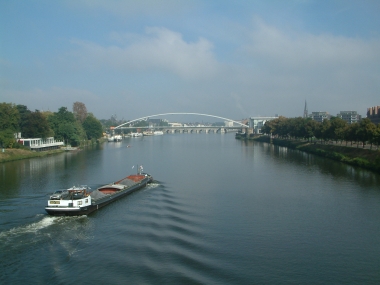
At Namur it is joined by the Sambre. Beyond Namur the Meuse winds eastwards and passes Liège before turning north. The river then forms part of the Belgian-Dutch border, except that at Maastricht the border lies further to the west. In the Netherlands it continues northwards through Venlo closely along the border to Germany, then turns towards the west, where it runs parallel to the Waal and forms part of the extensive Rhine–Meuse–Scheldt delta, together with the Scheldt to its south and the Rhine to the north. The river has been divided near Heusden into the Afgedamde Maas on the right and the Bergse Maas on the left. The Bergse Maas continues under the name of Amer, which is part of De Biesbosch. The Afgedamde Maas joins the Waal, the main stem of the Rhine at Woudrichem, and then flows under the name of Boven Merwede to Hardinxveld-Giessendam, where it splits into Nieuwe Merwede and Beneden Merwede. Near Lage Zwaluwe, the Nieuwe Merwede joins the Amer, forming the Hollands Diep, which splits into Grevelingen and Haringvliet, before finally flowing into the North Sea.
The Meuse is crossed by railway bridges between the following stations (on the left and right banks respectively):
- Belgium:
- Hasselt (Belgium) – Maastricht (Netherlands)
- Netherlands:
- Weert - Roermond
- Blerick – Venlo
- Cuijk – Mook-Molenhoek
- Ravenstein – Wijchen
- 's-Hertogenbosch – Zaltbommel
There are also numerous road bridges and around 32 ferry crossings.
The Meuse is navigable over a substantial part of its total length: In the Netherlands and Belgium, the river is part of the major inland navigation infrastructure, connecting the Rotterdam-Amsterdam-Antwerp port areas to the industrial areas upstream: 's-Hertogenbosch, Venlo, Maastricht, Liège, Namur. Between Maastricht and Maasbracht, an unnavigable section of the Meuse is bypassed by the 36 km Juliana Canal. South of Namur, further upstream, the river can only carry more modest vessels, although a barge as long as 100 m. can still reach the French border town of Givet.
From Givet, the river is canalized over a distance of 272 km. The canalized Meuse used to be called the "Canal de l'Est — Branche Nord" but was recently rebaptized into "Canal de la Meuse". The waterway can be used by the smallest barges that are still in use commercially almost 40 m long and just over 5 m wide. Just upstream of the town of Commercy, the Canal de la Meuse connects with the Marne–Rhine Canal by means of a short diversion canal.
The Cretaceous sea reptile Mosasaurus is named after the river Meuse. The first fossils of it were discovered outside Maastricht in 1780.
Basin area

.jpg)


An international agreement was signed in 2002 in Ghent, Belgium, about the management of the river amongst France, Germany, Luxembourg, the Netherlands, and Belgium. Also participating in the agreement were the Belgian regional governments of Flanders, Wallonia, and Brussels (which is not in the basin of the Meuse but pumps running water into the Meuse).
Most of the basin area (approximately 36,000 km2) is in Wallonia (12,000 km2), followed by France (9,000 km2), the Netherlands (8,000 km2), Germany (2,000 km2), Flanders (2,000 km2) and Luxembourg (a few km2).
An International Commission on the Meuse has the responsibility of the implementation of the treaty.
The costs of this Commission are met by all these countries, in proportion of their own territory in the basin of the Meuse: Netherlands 30%, Wallonia 30%, France 15%, Germany 14.5%, Flanders 5%, Brussels 4.5%, Kingdom of Belgium 0.5%, and Luxembourg 0.5%.
The map of the basin area of Meuse was joined to the text of the treaty.
As for culture, as a major communication route the River Meuse is the origin of Mosan art, principally (Wallonia and France).
The first landscape painted in the Renaissance was the landscape of Meuse by Joachim Patinir. He was likely the uncle of Henri Blès, who is sometimes defined as a Mosan landscape painter active during the second third of the 16th century (i.e. second generation of landscape painters).
Tributaries
The main tributaries of the Meuse are listed below in downstream-upstream order, with the town where the tributary meets the river:
- Dieze (near 's-Hertogenbosch)
- Aa (in 's-Hertogenbosch)
- Binnendieze (in 's-Hertogenbosch)
- Dommel (in 's-Hertogenbosch)
- Gender (in Eindhoven)
- Raam (in Grave)
- Niers (in Gennep)
- Swalm (in Swalmen)
- Rur/Roer (in Roermond)
- Wurm (in Heinsberg, Germany)
- Merzbach (in Linnich, Germany)
- Inde (in Jülich, Germany)
- Kingbeek (near Illikhoven)
- Geleenbeek (near Maasbracht)
- Geul (near Meerssen)
- Geer/Jeker (in Maastricht)
- Yerne (in Lens-sur-Geer)
- Voer/Fouron (in Eijsden)
- Berwinne/Berwijn (near Moelingen, part of Voeren)
- Ourthe (in Liège)
- Weser/Vesdre (near Liège)
- Amel/Amblève (in Comblain-au-Pont)
- Salm (in Trois-Ponts)
- Warche (near Malmedy)
- Hoyoux (in Huy)
- Mehaigne (in Wanze)
- Sambre (in Namur)
- Houyoux (in Namur)
- Bocq (in Yvoir)
- Molignée (in Anhée)
- Lesse (in Anseremme, part of Dinant)
- Viroin (in Vireux-Molhain)
- Faux (in Revin)
- Semois or Semoy (in Monthermé)
- Sormonne (in Warcq)
- Bar (near Dom-le-Mesnil)
- Chiers (in Bazeilles)
- Othain (in Montmédy)
- Vair (in Maxey-sur-Meuse)
- Mouzon (in Neufchâteau, Vosges)
- Saônelle (in Coussey)
Distributaries
Main article: Bergse Maas, Afgedamde Maas, Oude Maas, Nieuwe Maas
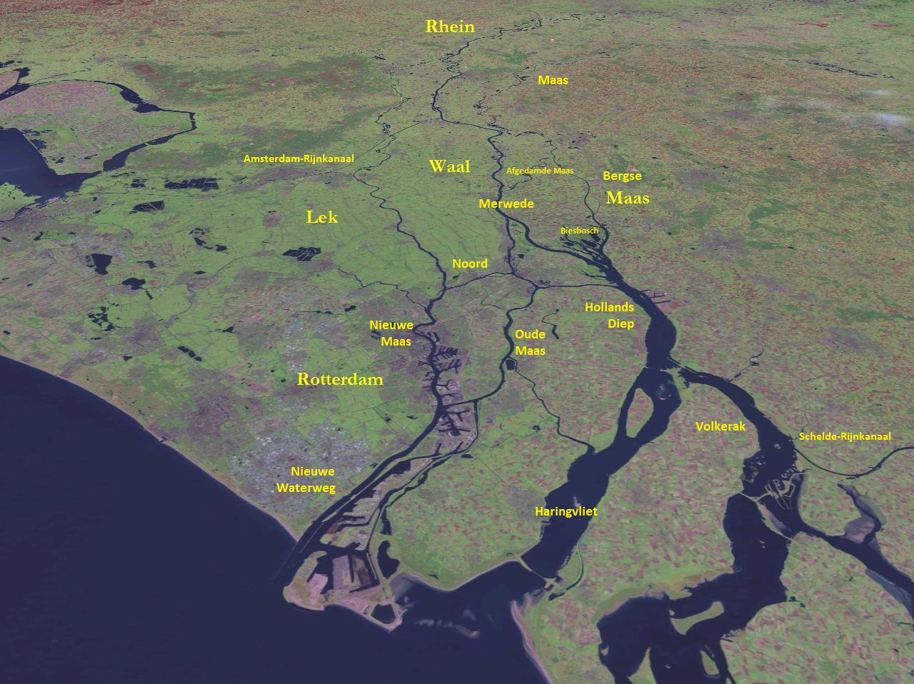
However during another series of severe floods the Meuse found an additional path towards the sea, resulting in the creation of the Biesbosch wetlands and Hollands Diep estuaries. Thereafter the Meuse split near Heusden into two main distributaries, one flowing north to join the Merwede and one flowing direct to the sea. The branch of the Meuse leading direct to the sea eventually silted up (and now forms the Oude Maasje stream), but in 1904 the canalised Bergse Maas was dug to take over the functions of the silted-up branch. At the same time the branch leading to the Merwede was dammed at Heusden (and has since been known as the Afgedamde Maas) so that little water from the Meuse entered the old Maas courses or the Rhine distributaries. The resulting separation of the rivers Rhine and Meuse is considered to be the greatest achievement in Dutch hydraulic engineering before the completion of the Zuiderzee Works and Delta Works.
A 2008 study notes that the difference between summer and winter flow volumes has increased significantly in the last 100–200 years. It points out that the frequency of serious floods (i.e. flows 1000% of normal) has increased markedly. They predict that winter flooding of the Meuse may become a recurring problem in the coming decades.
Départements, provinces and towns
The Meuse flows through the following departments of France, provinces of Belgium, provinces of the Netherlands and towns:
- France Haute-Marne
- France Vosges: Neufchâteau
- France Meuse: Commercy, Saint-Mihiel, Verdun, Stenay
- France Ardennes: Sedan, Charleville-Mézières, Givet
- Belgium Namur: Dinant, Namur
- Belgium Liège: Huy, Liège, Visé
- Netherlands Limburg: Eijsden, Maastricht, Stein, Maasbracht, Roermond, Venlo, Gennep
- Belgium Limburg: Stokkem, Maaseik (between Stein and Maasbracht)
- Netherlands North Brabant: Boxmeer, Cuijk, Grave, Ravenstein, Lith, Heusden, Aalburg, Woudrichem
- Netherlands Gelderland: Maasdriel
- Netherlands South Holland: Dordrecht, Maassluis, Rotterdam
Detailed route
Main cities and tributaries will be in bold.
| Region | Municipality on the left bank | Municipality on the right bank | Route | ||
|---|---|---|---|---|---|
| EU France Grand Est Haute-Marne | Le Châtelet-sur-Meuse | Le Châtelet-sur-Meuse | Source near Pouilly-en-Bassigny | ||
| Dammartin-sur-Meuse | Dammartin-sur-Meuse | [[File:Panneau d'Agglomération France.png | frameless | 20x20px]] Malroy | |
| Val-de-Meuse | Val-de-Meuse | [[File:Panneau d'Agglomération France.png | frameless | 20x20px]] Meuse | |
| Lavilleneuve | Val-de-Meuse | [[File:SADC road sign GLS-1.svg | frameless | 20x20px]] Ruisseau de Rangecourt | |
| Val-de-Meuse | [[File:Panneau d'Agglomération France.png | frameless | 20x20px]] Lénizeul | ||
| Bassoncourt | Bassoncourt | [[File:SADC road sign GLS-1.svg | frameless | 20x20px]] Ruisseau du Soilleron | |
| Breuvannes-en-Bassigny | Breuvannes-en-Bassigny | [[File:SADC road sign GLS-1.svg | frameless | 20x20px]] Ruisseau des Noues | |
| Clefmont | Clefmont | / | |||
| Audeloncourt | Audeloncourt | [[File:SADC road sign GLS-1.svg | frameless | 20x20px]] Ruisseau du Grand Pré | |
| Levécourt | Levécourt | [[File:SADC road sign GLS-1.svg | frameless | 20x20px]] Ruisseau de la Hourie | |
| Huilliécourt | Doncourt-sur-Meuse | / | |||
| Hâcourt | Hâcourt | [[File:Segnale stradale italiano 1981 - ponte (viabilità ordinaria - senza pannelli).svg | frameless | 20x20px]] Pont de Hâcourt | |
| Bourg-Sainte-Marie | [[File:Panneau d'Agglomération France.png | frameless | 20x20px]] Hâcourt | ||
| Brainville-sur-Meuse | [[File:Segnale stradale italiano 1981 - ponte (viabilità ordinaria - senza pannelli).svg | frameless | 20x20px]] Pont de Bourg-Sainte-Marie (D119) | ||
| Bourmont-entre-Meuse-et-Mouzon | Bourmont-entre-Meuse-et-Mouzon | [[File:Panneau d'Agglomération France.png | frameless | 20x20px]] Bourmont | |
| Saint-Thiébault | [[File:Panneau d'Agglomération France.png | frameless | 20x20px]] Saint-Thiébault | ||
| Bourmont-entre-Meuse-et-Mouzon | [[File:Segnale stradale italiano 1981 - ponte (viabilità ordinaria - senza pannelli).svg | frameless | 20x20px]] Pont de Gonaincourt (D119) | ||
| Harréville-les-Chanteurs | Harréville-les-Chanteurs | [[File:Segnale stradale italiano 1981 - ponte (viabilità ordinaria - senza pannelli).svg | frameless | 20x20px]] Railway bridges Culmont-Chalindrey - Toul line (2x) | |
| EU France Grand Est Vosges | Bazoilles-sur-Meuse | Bazoilles-sur-Meuse | [[File:Segnale stradale italiano 1981 - ponte (viabilità ordinaria - senza pannelli).svg | frameless | 20x20px]] Railway bridges Culmont-Chalindrey - Toul line (2x) |
| Neufchâteau | Neufchâteau | [[File:Segnale stradale italiano 1981 - ponte (viabilità ordinaria - senza pannelli).svg | frameless | 20x20px]] Railway bridge Culmont-Chalindrey - Toul line | |
| Frebécourt | Frebécourt | *[[File:Segnale stradale italiano 1981 - ponte (viabilità ordinaria - senza pannelli).svg | frameless | 20x20px]] Pont de Frebécourt* | |
| Coussey | Coussey | [[File:Panneau d'Agglomération France.png | frameless | 20x20px]] Coussey | |
| Domrémy-la-Pucelle | Domrémy-la-Pucelle | *[[File:Segnale stradale italiano 1981 - ponte (viabilità ordinaria - senza pannelli).svg | frameless | 20x20px]] Pont de Domrémy-la-Pucelle (D164 Neufchâteau - Greux)* | |
| Greux | Maxey-sur-Meuse | **[[File:SADC road sign GLS-1.svg | frameless | 20x20px]] Vair** | |
| Maxey-sur-Meuse | [[File:Panneau d'Agglomération France.png | frameless | 20x20px]] Maxey-sur-Meuse | ||
| EU France Grand Est Meuse France | Brixey-aux-Chanoines | Brixey-aux-Chanoines | *[[File:Segnale stradale italiano 1981 - ponte (viabilità ordinaria - senza pannelli).svg | frameless | 20x20px]] Pont de Brixey-aux-Chanoines* |
| Sauvigny | Sauvigny | [[File:SADC road sign GLS-1.svg | frameless | 20x20px]] Ruisseau de Ruppes | |
| Montbras | / | ||||
| Sauvigny | *[[File:Segnale stradale italiano 1981 - ponte (viabilità ordinaria - senza pannelli).svg | frameless | 20x20px]] Pont de Traveron* | ||
| Pagny-la-Blanche-Côte | Pagny-la-Blanche-Côte | [[File:SADC road sign GLS-1.svg | frameless | 20x20px]] Rivière de Chêtre | |
| Montbras | Champougny | / | |||
| Taillancourt | [[File:SADC road sign GLS-1.svg | frameless | 20x20px]] La Haute Meuse | ||
| Champougny | [[File:Panneau d'Agglomération France.png | frameless | 20x20px]] Champougny | ||
| Maxey-sur-Vaise | Maxey-sur-Vaise | / | |||
| Burey-en-Vaux | Sepvigny | / | |||
| Sepvigny | *[[File:Segnale stradale italiano 1981 - ponte (viabilità ordinaria - senza pannelli).svg | frameless | 20x20px]] Pont de Sepvigny (D145)* | ||
| Neuville-lès-Vaucouleurs | Neuville-lès-Vaucouleurs | / | |||
| Vaucouleurs | Chalaines | [[File:Panneau d'Agglomération France.png | frameless | 20x20px]] Chalaines | |
| Ugny-sur-Meuse | Rigny-la-Salle | [[File:SADC road sign GLS-1.svg | frameless | 20x20px]] Le Goulot de Meuse | |
| Saint-Germain-sur-Meuse | *[[File:Segnale stradale italiano 1981 - ponte (viabilità ordinaria - senza pannelli).svg | frameless | 20x20px]] Pont de Ugny-sur-Meuse (D36)* | ||
| Ugny-sur-Meuse | Ourches-sur-Meuse | [[File:Panneau d'Agglomération France.png | frameless | 20x20px]] Ourches-sur-Meuse | |
| Pagny-sur-Meuse | Pagny-sur-Meuse | *[[File:Segnale stradale italiano 1981 - ponte (viabilità ordinaria - senza pannelli).svg | frameless | 20x20px]] Pont de Pagny-sur-Meuse (N4 Paris - Strasbourg)* | |
| Troussey | Troussey | [[File:Panneau d'Agglomération France.png | frameless | 20x20px]] Troussey | |
| Void-Vacon | Sorcy-Saint-Martin | [[File:SADC road sign GLS-1.svg | frameless | 20x20px]] Ruisseau de Frasne | |
| Sorcy-Saint-Martin | *[[File:Segnale stradale italiano 1981 - ponte (viabilità ordinaria - senza pannelli).svg | frameless | 20x20px]] Pont de Sorcy-Saint-Martin (D10)* | ||
| Sorcy-Saint-Martin | Euville | *[[File:Segnale stradale italiano 1981 - ponte (viabilità ordinaria - senza pannelli).svg | frameless | 20x20px]] Railway bridge Paris-Est–Strasbourg-Ville line* | |
| Commercy | Commercy | [[File:SADC road sign GLS-1.svg | frameless | 20x20px]] Canal de l'Est | |
| Vignot | Vignot | [[File:SADC road sign GLS-1.svg | frameless | 20x20px]] Ruisseau d'Aulnois | |
| Commercy | Commercy | *[[File:Segnale stradale italiano 1981 - ponte (viabilità ordinaria - senza pannelli).svg | frameless | 20x20px]] Pont de Rte de Boncourt (D8A)* | |
| Lérouville | Commercy | [[File:SADC road sign GLS-1.svg | frameless | 20x20px]] Canal de l'Est | |
| Boncourt-sur-Meuse | Boncourt-sur-Meuse | *[[File:Segnale stradale italiano 1981 - ponte (viabilità ordinaria - senza pannelli).svg | frameless | 20x20px]] Railway bridge Lérouville - Metz line* | |
| Pont-sur-Meuse | Pont-sur-Meuse | [[File:Panneau d'Agglomération France.png | frameless | 20x20px]] Pont-sur-Meuse | |
| Vadonville | / | ||||
| Mécrin | Mécrin | *[[File:Segnale stradale italiano 1981 - ponte (viabilità ordinaria - senza pannelli).svg | frameless | 20x20px]] Pont de Mécrin (D12A)* | |
| Sampigny | Han-sur-Meuse | [[File:SADC road sign GLS-1.svg | frameless | 20x20px]] Rivière de Mont | |
| Han-sur-Meuse | [[File:Panneau d'Agglomération France.png | frameless | 20x20px]] Brasseitte | ||
| Saint-Mihiel | *[[File:Segnale stradale italiano 1981 - ponte (viabilità ordinaria - senza pannelli).svg | frameless | 20x20px]] Pont de Han-sur-Meuse (D7A)* | ||
| Kœur-la-Petite | Bislée | *[[File:Segnale stradale italiano 1981 - ponte (viabilità ordinaria - senza pannelli).svg | frameless | 20x20px]] Pont de D964 (Commercy - Verdun)* | |
| Kœur-la-Grande | *[[File:Segnale stradale italiano 1981 - ponte (viabilità ordinaria - senza pannelli).svg | frameless | 20x20px]] Pont de Bislée (D171)* | ||
| Chauvoncourt | [[File:SADC road sign GLS-1.svg | frameless | 20x20px]] Canal de l'Est | ||
| Chauvoncourt | [[File:Panneau d'Agglomération France.png | frameless | 20x20px]] Menonville | ||
| Saint-Mihiel | Saint-Mihiel | [[File:SADC road sign GLS-1.svg | frameless | 20x20px]] Canal de l'Est | |
| Les Paroches | Maizey | [[File:SADC road sign GLS-1.svg | frameless | 20x20px]] Le Rehaut | |
| Maizey | [[File:Panneau d'Agglomération France.png | frameless | 20x20px]] Maizy | ||
| Dompcevrin | *[[File:Segnale stradale italiano 1981 - ponte (viabilità ordinaria - senza pannelli).svg | frameless | 20x20px]] Pont de Maizy (D101)* | ||
| Bannoncourt | Rouvrois-sur-Meuse | / | |||
| Bannoncourt | [[File:SADC road sign GLS-1.svg | frameless | 20x20px]] La Petite Meuse | ||
| Lacroix-sur-Meuse | [[File:SADC road sign GLS-1.svg | frameless | 20x20px]] La Prêle | ||
| Woimbey | / | ||||
| Troyon | Troyon | *[[File:Segnale stradale italiano 1981 - ponte (viabilità ordinaria - senza pannelli).svg | frameless | 20x20px]] Pont de Troyon* | |
| Bouquemont | / | ||||
| Tilly-sur-Meuse | / | ||||
| Tilly-sur-Meuse | *[[File:Segnale stradale italiano 1981 - ponte (viabilità ordinaria - senza pannelli).svg | frameless | 20x20px]] Pont de Tilly-sur-Meuse* | ||
| Ambly-sur-Meuse | [[File:SADC road sign GLS-1.svg | frameless | 20x20px]] Ruisseau de Récourt | ||
| Villers-sur-Meuse | Villers-sur-Meuse | [[File:Panneau d'Agglomération France.png | frameless | 20x20px]] Villers-sur-Meuse | |
| Les Monthairons | Les Monthairons | *[[File:Segnale stradale italiano 1981 - ponte (viabilità ordinaria - senza pannelli).svg | frameless | 20x20px]] Pont de Rue du Lavoir* | |
| Dieue-sur-Meuse | Dieue-sur-Meuse | [[File:SADC road sign GLS-1.svg | frameless | 20x20px]] Le Clair Fossé | |
| Dugny-sur-Meuse | Haudainville | *[[File:Segnale stradale italiano 1981 - ponte (viabilità ordinaria - senza pannelli).svg | frameless | 20x20px]] Pont de l'Autoroute A4 (Paris - Strasbourg)* | |
| Belleray | Belleray | *[[File:Segnale stradale italiano 1981 - ponte (viabilità ordinaria - senza pannelli).svg | frameless | 20x20px]] Pont de Belleray (D301)* | |
| Verdun | Verdun | [[File:SADC road sign GLS-1.svg | frameless | 20x20px]] Saint Vanne | |
| Belleville-sur-Meuse | Thierville-sur-Meuse | *[[File:Segnale stradale italiano 1981 - ponte (viabilità ordinaria - senza pannelli).svg | frameless | 20x20px]] Railway bridge St-Hilaire-au-Temple-Hagondange line (Verdun-Metz)* | |
| Charny-sur-Meuse | Bras-sur-Meuse | [[File:Panneau d'Agglomération France.png | frameless | 20x20px]] Charny-sur-Meuse | |
| Vacherauville | Vacherauville | [[File:Panneau d'Agglomération France.png | frameless | 20x20px]] Vacherauville | |
| Marre | Champneuville | [[File:SADC road sign GLS-1.svg | frameless | 20x20px]] Ruisseau de la Claire | |
| Chattancourt | / | ||||
| Champneuville | *[[File:Segnale stradale italiano 1981 - ponte (viabilità ordinaria - senza pannelli).svg | frameless | 20x20px]] Pont de Champneuville (D214)* | ||
| Cumières-le-Mort-Homme | / | ||||
| Regnéville-sur-Meuse | Samogneux | [[File:Panneau d'Agglomération France.png | frameless | 20x20px]] Regnéville-sur-Meuse | |
| Forges-sur-Meuse | Brabant-sur-Meuse | [[File:SADC road sign GLS-1.svg | frameless | 20x20px]] Ruisseau de Forges | |
| Consenvoye | Consenvoye | *[[File:Segnale stradale italiano 1981 - ponte (viabilità ordinaria - senza pannelli).svg | frameless | 20x20px]] Pont de Consenvoye* | |
| Dannevoux | Sivry-sur-Meuse | [[File:SADC road sign GLS-1.svg | frameless | 20x20px]] Canal de l'Est | |
| Vilosnes-Haraumont | Vilosnes-Haraumont | [[File:SADC road sign GLS-1.svg | frameless | 20x20px]] Canal de l'Est | |
| Brieulles-sur-Meuse | Brieulles-sur-Meuse | [[File:SADC road sign GLS-1.svg | frameless | 20x20px]] Ruisseau de Domfontaine | |
| Cléry-le-Petit | Liny-devant-Dun | [[File:SADC road sign GLS-1.svg | frameless | 20x20px]] Le Doua | |
| Dun-sur-Meuse | [[File:SADC road sign GLS-1.svg | frameless | 20x20px]] Canal de l'Est | ||
| Doulcon | [[File:Panneau d'Agglomération France.png | frameless | 20x20px]] Dun-sur-Meuse | ||
| Sassey-sur-Meuse | Milly-sur-Bradon | [[File:SADC road sign GLS-1.svg | frameless | 20x20px]] Ruisseau de Bradon | |
| Sassey-sur-Meuse | [[File:Panneau d'Agglomération France.png | frameless | 20x20px]] Sassey-sur-Meuse | ||
| Mont-devant-Sassey | [[File:SADC road sign GLS-1.svg | frameless | 20x20px]] Ruisseau de Mont | ||
| Saulmory-Villefranche | Mouzay | [[File:SADC road sign GLS-1.svg | frameless | 20x20px]] Ruisseau de Froide Fontaine | |
| Wiseppe | / | ||||
| Stenay | [[File:SADC road sign GLS-1.svg | frameless | 20x20px]] Canal de l'Est | ||
| Stenay | *[[File:Segnale stradale italiano 1981 - ponte (viabilità ordinaria - senza pannelli).svg | frameless | 20x20px]] Pont de Stenay (D947 Stenay - Montmédy)* | ||
| Martincourt-sur-Meuse | Martincourt-sur-Meuse | *[[File:Segnale stradale italiano 1981 - ponte (viabilità ordinaria - senza pannelli).svg | frameless | 20x20px]] Pont de Martincourt-sur-Meuse* | |
| Luzy-Saint-Martin | Inor | [[File:SADC road sign GLS-1.svg | frameless | 20x20px]] Ruisseau de Cesse | |
| Pouilly-sur-Meuse | [[File:SADC road sign GLS-1.svg | frameless | 20x20px]] Ruisseau du Fond de Noue | ||
| Pouilly-sur-Meuse | *[[File:Segnale stradale italiano 1981 - ponte (viabilità ordinaria - senza pannelli).svg | frameless | 20x20px]] Pont de Pouilly-sur-Meuse* | ||
| EU France Grand Est Ardennes/Meuse | Létanne Ardennes | Pouilly-sur-Meuse Meuse | [[File:SADC road sign GLS-1.svg | frameless | 20x20px]] La Wame |
| EU France Grand Est Ardennes | Létanne | Mouzon | [[File:SADC road sign GLS-1.svg | frameless | 20x20px]] Le Bras de Vincy |
| Mouzon | [[File:Panneau d'Agglomération France.png | frameless | 20x20px]] Mouzon | ||
| Autrecourt-et-Pourron | [[File:SADC road sign GLS-1.svg | frameless | 20x20px]] Yoncq | ||
| Villers-devant-Mouzon | [[File:Panneau d'Agglomération France.png | frameless | 20x20px]] Villers-devant-Mouzon | ||
| Remilly-Aillicourt | Douzy | / | |||
| Remilly-Aillicourt | [[File:Panneau d'Agglomération France.png | frameless | 20x20px]] Petit Remilly | ||
| Bazeilles | [[File:SADC road sign GLS-1.svg | frameless | 20x20px]] Chiers | ||
| Noyers-Pont-Maugis | [[File:SADC road sign GLS-1.svg | frameless | 20x20px]] Ruisseau de Thélonne | ||
| Balan | [[File:SADC road sign GLS-1.svg | frameless | 20x20px]] Ruisseau de Batelotte | ||
| Wadelincourt | [[File:Panneau d'Agglomération France.png | frameless | 20x20px]] Wadelincourt | ||
| Sedan | *[[File:Segnale stradale italiano 1981 - ponte (viabilità ordinaria - senza pannelli).svg | frameless | 20x20px]] Pont de Sedan (N43 Sedan - Charleville-Mézières)* | ||
| Sedan | *[[File:Segnale stradale italiano 1981 - ponte (viabilità ordinaria - senza pannelli).svg | frameless | 20x20px]] Pont de l'Avenue Philippoteaux (D8043A)* | ||
| Glaire | Floing | [[File:SADC road sign GLS-1.svg | frameless | 20x20px]] Ruz de Glaire | |
| Saint-Menges | [[File:SADC road sign GLS-1.svg | frameless | 20x20px]] Ruisseau du Bas Caillou | ||
| Donchery | [[File:SADC road sign GLS-1.svg | frameless | 20x20px]] Ruisseau de la Falizette | ||
| Sedan | [[File:Panneau d'Agglomération France.png | frameless | 20x20px]] Frénois (Sedan) | ||
| Donchery | *[[File:Segnale stradale italiano 1981 - ponte (viabilità ordinaria - senza pannelli).svg | frameless | 20x20px]] Pont de Donchery (D24)* | ||
| Villers-sur-Bar | [[File:SADC road sign GLS-1.svg | frameless | 20x20px]] Vrigne | ||
| Vrigne-Meuse | [[File:Panneau d'Agglomération France.png | frameless | 20x20px]] Vrigne-Meuse | ||
| Dom-le-Mesnil | [[File:SADC road sign GLS-1.svg | frameless | 20x20px]] Canal des Ardennes | ||
| Nouvion-sur-Meuse | [[File:Panneau d'Agglomération France.png | frameless | 20x20px]] Nouvion-sur-Meuse | ||
| Flize | [[File:SADC road sign GLS-1.svg | frameless | 20x20px]] Ruisseau des Trois Fontaines | ||
| Chalandry-Elaire | [[File:Panneau d'Agglomération France.png | frameless | 20x20px]] Elaire (Chalandry-Elaire) | ||
| Les Ayvelles | Lumes | [[File:Panneau d'Agglomération France.png | frameless | 20x20px]] Lumes | |
| Lumes | *[[File:Segnale stradale italiano 1981 - ponte (viabilità ordinaria - senza pannelli).svg | frameless | 20x20px]] Railway bridge Mohon-Thionville line (Charleville-Mézières - Sedan)* | ||
| Villers-Semeuse | *[[File:Segnale stradale italiano 1981 - ponte (viabilità ordinaria - senza pannelli).svg | frameless | 20x20px]] Pont de Lumes (A34 Sedan - Charleville-Mézières)* | ||
| Saint-Laurent | [[File:SADC road sign GLS-1.svg | frameless | 20x20px]] Dérivation de Romery | ||
| Charleville-Mézières | [[File:Panneau d'Agglomération France.png | frameless | 20x20px]] Le Theux (Charleville-Mézières) | ||
| Charleville-Mézières | [[File:SADC road sign GLS-1.svg | frameless | 20x20px]] Vence | ||
| Prix-lès-Mézières | *[[File:Segnale stradale italiano 1981 - ponte (viabilità ordinaria - senza pannelli).svg | frameless | 20x20px]] Pont de Manchester (N43 Charleville-Mézières - Sedan)* | ||
| Warcq | [[File:Panneau d'Agglomération France.png | frameless | 20x20px]] Warcq | ||
| Charleville-Mézières | *[[File:Segnale stradale italiano 1981 - ponte (viabilità ordinaria - senza pannelli).svg | frameless | 20x20px]] Pont de N43 (Charleville-Mézières - Sedan)* | ||
| Montcy-Notre-Dame | [[File:SADC road sign GLS-1.svg | frameless | 20x20px]] Ruisseau de la Fontaine du Prince | ||
| Aiglemont | / | ||||
| Nouzonville | / | ||||
| Nouzonville | [[File:Panneau d'Agglomération France.png | frameless | 20x20px]] Nouzonville | ||
| Joigny-sur-Meuse | Joigny-sur-Meuse | *[[File:Segnale stradale italiano 1981 - ponte (viabilità ordinaria - senza pannelli).svg | frameless | 20x20px]] Pont de Joigny-sur-Meuse (D1A)* | |
| Bogny-sur-Meuse | Bogny-sur-Meuse | [[File:Panneau d'Agglomération France.png | frameless | 20x20px]] Braux | |
| Monthermé | *[[File:Segnale stradale italiano 1981 - ponte (viabilità ordinaria - senza pannelli).svg | frameless | 20x20px]] Railway bridge Soissons - Givet line (Charleville-Mézières - Givet)* | ||
| Monthermé | [[File:SADC road sign GLS-1.svg | frameless | 20x20px]] Semois | ||
| Deville | [[File:Panneau d'Agglomération France.png | frameless | 20x20px]] Deville | ||
| Laifour | [[File:SADC road sign GLS-1.svg | frameless | 20x20px]] Ruisseau de la Lambrèque | ||
| Revin | [[File:SADC road sign GLS-1.svg | frameless | 20x20px]] Ruisseau de la Grande Commune | ||
| Les Mazures | / | ||||
| Anchamps | *[[File:Segnale stradale italiano 1981 - ponte (viabilità ordinaria - senza pannelli).svg | frameless | 20x20px]] Railway bridge Soissons - Givet line (Charleville-Mézières - Givet)* | ||
| Revin | [[File:Panneau d'Agglomération France.png | frameless | 20x20px]] Orzy | ||
| Rocroi | *[[File:Segnale stradale italiano 1981 - ponte (viabilità ordinaria - senza pannelli).svg | frameless | 20x20px]] Pont de Saint-Nicolas* | ||
| Revin | *[[File:Segnale stradale italiano 1981 - ponte (viabilità ordinaria - senza pannelli).svg | frameless | 20x20px]] Pont de Fumay (D988 Charleville-Mézières - Givet)* | ||
| Fumay | [[File:SADC road sign GLS-1.svg | frameless | 20x20px]] Ruisseau de Come | ||
| Fumay | [[File:SADC road sign GLS-1.svg | frameless | 20x20px]] Ruisseau des Manises | ||
| Haybes | [[File:Panneau d'Agglomération France.png | frameless | 20x20px]] Fumay | ||
| Haybes | *[[File:Segnale stradale italiano 1981 - ponte (viabilità ordinaria - senza pannelli).svg | frameless | 20x20px]] Pont de la Guerre (D7B)* | ||
| Fépin | [[File:SADC road sign GLS-1.svg | frameless | 20x20px]] Ruisseau d'Hargnies | ||
| Montigny-sur-Meuse | Vireux-Wallerand | [[File:SADC road sign GLS-1.svg | frameless | 20x20px]] Risdoux | |
| Vireux-Molhain | [[File:Panneau d'Agglomération France.png | frameless | 20x20px]] Vireux-Molhain | ||
| Hierges | [[File:SADC road sign GLS-1.svg | frameless | 20x20px]] Viroin | ||
| Aubrives | Aubrives | [[File:Panneau d'Agglomération France.png | frameless | 20x20px]] Aubrives | |
| Ham-sur-Meuse | [[File:Panneau d'Agglomération France.png | frameless | 20x20px]] Ham-sur-Meuse | ||
| Chooz | [[File:France road sign ID35.svg | frameless | 20x20px]] Chooz Nuclear Power Plant | ||
| Chooz | *[[File:Segnale stradale italiano 1981 - ponte (viabilità ordinaria - senza pannelli).svg | frameless | 20x20px]] Pont de Chemin de Mission* | ||
| Rancennes | [[File:SADC road sign GLS-1.svg | frameless | 20x20px]] Le Fond des Vaux | ||
| Givet | / | ||||
| Givet | [[File:SADC road sign GLS-1.svg | frameless | 20x20px]] Ruisseau de Rancennes | ||
| EU France/Belgium Grand Est/Wallonia Ardennes/Namur | Givet France | Hastière Belgium | [[File:SADC road sign GLS-1.svg | frameless | 20x20px]] Ruisseau de Mon Idée |
| EU Belgium Wallonia Namur | Hastière | Hastière | [[File:Belgian road sign F1bh.svg | frameless | 20x20px]] Heer-Agimont |
| Dinant | [[File:Belgian road sign F1bh.svg | frameless | 20x20px]] Freÿr (Hastière) | ||
| Dinant | [[File:Belgian road sign F1bh.svg | frameless | 20x20px]] Anseremme | ||
| Yvoir | / | ||||
| Anhée | [[File:Belgian road sign F1bh.svg | frameless | 20x20px]] Houx (Yvoir) | ||
| Profondeville | [[File:Belgian road sign F1bh.svg | frameless | 20x20px]] Godinne (Yvoir) | ||
| Profondeville | [[File:Belgian road sign F1bh.svg | frameless | 20x20px]] Burnot | ||
| Namur | [[File:Belgian road sign F1bh.svg | frameless | 20x20px]] Boreuville (Namur) | ||
| Namur | *[[File:Segnale stradale italiano 1981 - ponte (viabilità ordinaria - senza pannelli).svg | frameless | 20x20px]] Pont de Wépion* | ||
| Andenne | Andenne | [[File:SADC road sign GLS-1.svg | frameless | 20x20px]] Samson | |
| EU Belgium Wallonia Liège | Wanze | Huy | [[File:Belgian road sign F1bh.svg | frameless | 20x20px]] Gisves (Huy) |
| Huy | [[File:Belgian road sign F1bh.svg | frameless | 20x20px]] Anhin | ||
| Amay | [[File:France road sign ID35.svg | frameless | 20x20px]] Tihange Nuclear Power Station | ||
| Amay | *[[File:Segnale stradale italiano 1981 - ponte (viabilità ordinaria - senza pannelli).svg | frameless | 20x20px]] Pont d'Ombret (N696)* | ||
| Engis | [[File:SADC road sign GLS-1.svg | frameless | 20x20px]] Ruisseau d'Oxhe | ||
| Saint-Georges-sur-Meuse | *[[File:Segnale stradale italiano 1981 - ponte (viabilità ordinaria - senza pannelli).svg | frameless | 20x20px]] Pont de Hermalle* | ||
| Engis | [[File:Belgian road sign F1bh.svg | frameless | 20x20px]] Engis | ||
| Flémalle | Flémalle | [[File:Belgian road sign F1bh.svg | frameless | 20x20px]] Ramioul | |
| Seraing | [[File:SADC road sign GLS-1.svg | frameless | 20x20px]] Ruisseau de Ville en Cour | ||
| Seraing | [[File:Belgian road sign F1bh.svg | frameless | 20x20px]] Troque | ||
| Saint-Nicolas | [[File:Belgian road sign F1bh.svg | frameless | 20x20px]] Tilleur (Saint-Nicolas) | ||
| Liège | [[File:Belgian road sign F1bh.svg | frameless | 20x20px]] Ougrée (Seraing) | ||
| Liège | [[File:Belgian road sign F1bh.svg | frameless | 20x20px]] Kinkempois | ||
| Herstal | [[File:Belgian road sign F1bh.svg | frameless | 20x20px]] Herstal | ||
| Oupeye | Visé | [[File:Belgian road sign F1bh.svg | frameless | 20x20px]] Cheratte (Visé) | |
| Visé | [[File:Belgian road sign F1bh.svg | frameless | 20x20px]] Visé | ||
| EU Belgium Wallonia/Flanders Liège/Limburg (Belgium) | Visé Wallonia | Voeren Flanders | [[File:Belgian road sign F1bh.svg | frameless | 20x20px]] Lixhe (Visé) |
| EU Belgium/Netherlands Wallonia/Limburg (Netherlands) Liège Belgium / Netherlands | Visé Belgium | Eijsden-Margraten Netherlands | [[File:SADC road sign GLS-1.svg | frameless | 20x20px]] Voer |
| EU Netherlands Limburg (Netherlands) | Maastricht | Maastricht | [[File:Netherlands traffic sign NL H1a.svg | frameless | 42x42px]] Maastricht |
| EU Belgium/Netherlands Flanders/Limburg (Netherlands) Limburg (Belgium) Belgium / Netherlands | Lanaken Belgium | Maastricht Netherlands | [[File:Belgian road sign F1bh.svg | frameless | 20x20px]] Smeermaas (Lanaken) |
| Maasmechelen Belgium | Meerssen Netherlands | [[File:SADC road sign GLS-1.svg | frameless | 20x20px]] Geul | |
| Stein Netherlands | [[File:Belgian road sign F1bh.svg | frameless | 20x20px]] Kotem | ||
| Dilsen-Stokkem Belgium | Sittard-Geleen Netherlands | [[File:Netherlands traffic sign NL H1a.svg | frameless | 42x42px]] Obbicht (Sittard-Geleen) | |
| Echt-Susteren Netherlands | [[File:Netherlands traffic sign NL H1a.svg | frameless | 42x42px]] Illikhoven (Sittard-Geleen) | ||
| Maaseik Belgium | [[File:Belgian road sign F1bh.svg | frameless | 20x20px]] Heppeneert (Maaseik) | ||
| Maasgouw Netherlands | [[File:Netherlands traffic sign NL H1a.svg | frameless | 42x42px]] Ohé en Laak (Maasgouw) | ||
| Kinrooi Belgium | [[File:Belgian road sign F1bh.svg | frameless | 20x20px]] Ophoven (Kinrooi) | ||
| EU Netherlands Limburg (Netherlands) | Maasgouw | Maasgouw | [[File:Netherlands traffic sign NL H1a.svg | frameless | 42x42px]] Maasbracht |
| Roermond | [[File:SADC road sign GLS-1.svg | frameless | 20x20px]] Vlootbeek | ||
| Roermond | [[File:Netherlands traffic sign NL H1a.svg | frameless | 42x42px]] Merum | ||
| Leudal | [[File:SADC road sign GLS-1.svg | frameless | 20x20px]] Linne-Buggenum Canal | ||
| Beesel | [[File:Thailand road sign Ferry Port.svg | frameless | 20x20px]] Bike ferry service Neer - Rijkel | ||
| Peel en Maas | [[File:Netherlands traffic sign NL H1a.svg | frameless | 42x42px]] Beesel | ||
| Venlo | [[File:Netherlands traffic sign NL H1a.svg | frameless | 42x42px]] Oijen (Peel en Maas) | ||
| Venlo | [[File:SADC road sign GLS-1.svg | frameless | 20x20px]] Engerbeek | ||
| Horst aan de Maas | [[File:SADC road sign GLS-1.svg | frameless | 20x20px]] Stopbeek | ||
| Bergen | [[File:SADC road sign GLS-1.svg | frameless | 20x20px]] Geldernsch-Nierkanaal | ||
| Venray | [[File:Netherlands traffic sign NL H1a.svg | frameless | 42x42px]] Wellerlooi (Bergen) | ||
| EU Netherlands Limburg (Netherlands)/Noord-Brabant | Land van Cuijk Noord-Brabant | Bergen Limburg (Netherlands) | [[File:Netherlands traffic sign NL H1a.svg | frameless | 42x42px]] Maashees |
| Gennep Limburg (Netherlands) | [[File:Netherlands traffic sign NL H1a.svg | frameless | 42x42px]] Boxmeer (Land van Cuijk) | ||
| Mook en Middelaar Limburg (Netherlands) | [[File:Netherlands traffic sign NL H1a.svg | frameless | 42x42px]] Sint-Agatha (Land van Cuijk) | ||
| EU Netherlands Gelderland/Noord-Brabant | Heumen Gelderland | [[File:SADC road sign GLS-1.svg | frameless | 20x20px]] Maas–Waal Canal | |
| Wijchen Gelderland | [[File:Netherlands traffic sign NL H1a.svg | frameless | 42x42px]] Balgoij (Wijchen) | ||
| Oss Noord-Brabant | [[File:Netherlands traffic sign NL H1a.svg | frameless | 42x42px]] Keent (Oss) | ||
| West Maas en Waal Gelderland | [[File:SADC road sign GLS-1.svg | frameless | 20x20px]] Nieuwe Wetering | ||
| Maasdriel Gelderland | [[File:Netherlands traffic sign NL H1a.svg | frameless | 42x42px]] Voorne (Maasdriel) | ||
| 's-Hertogenbosch Noord-Brabant | [[File:Netherlands traffic sign NL H1a.svg | frameless | 42x42px]] Gewande ('s-Hertogenbosch) | ||
| Heusden Noord-Brabant | [[File:Netherlands traffic sign NL H1a.svg | frameless | 42x42px]] Well (Maasdriel) | ||
| Zaltbommel Gelderland | [[File:Thailand road sign Ferry Port.svg | frameless | 20x20px]] Car ferry service Bern - Herpt | ||
| EU Netherlands Noord-Brabant | Heusden | Altena | *[[File:Segnale stradale italiano 1981 - ponte (viabilità ordinaria - senza pannelli).svg | frameless | 20x20px]] Maasbrug van Heusden (N267 Heusden - Giessen)* |
| Waalwijk | [[File:SADC road sign GLS-1.svg | frameless | 20x20px]] Afwateringskanaal 's-Hertogenbosch - Drongelen | ||
| Geertruidenberg | [[File:Netherlands traffic sign NL H1a.svg | frameless | 42x42px]] Peerenboom (Altena) |
Mention in patriotic songs
The Meuse (Maas) is mentioned in the first stanza of Germany's old national anthem, the Deutschlandlied. However, since its re-adoption as national anthem in 1952, only the third stanza of the Deutschlandlied has been sung as the German national anthem, the first and second stanzas being omitted. This was confirmed after German reunification in 1991 when only the third stanza was defined as the official anthem. The lyrics written in 1841 describe a then–disunited Germany with the river as its western boundary, where King William I of the Netherlands had joined the German Confederation with his Duchy of Limburg in 1839. Though the duchy's territory officially became an integral part of the Netherlands by the 1867 Treaty of London, the text passage remained unchanged when the Deutschlandlied was declared the national anthem of the Weimar Republic in 1922.
The name of the rivers also forms part of the title of "Le Régiment de Sambre et Meuse", written after the French defeat in the Franco-Prussian War of 1870, and a popular patriotic song for the rest of the 19th century and into the 20th.
Notes
References
References
- Marcel de Wit, Robert Leander, Adri Buishand: ''[http://www.chr-khr.org/files/I-2_deWit.pdf Extreme discharges in the Meuse basin] {{webarchive. link. (2014-01-06 '', p. 2
(The frequently mentioned figure of 250 m3/s refers to the ''Borgharen'' gauge near the frontier between Belgium and the Netherlands representing two thirds of the basin.)) - {{Cite American Heritage Dictionary. Meuse
- "Meuse". [[Oxford University Press]].
- {{Cite Merriam-Webster. Meuse
- "Maas". [[Oxford University Press]].
- Loo, Bart van. (2021). "The Burgundians: A Vanished Empire: A History of 1111 Years and One Day".
- "Wallonie : une région en Europe". Ministère de la Région wallonne.
- Van der Aalst & De Jongh. (2004). "Honderd Jaar Bergse Maas". Pictures Publishing.
- Wols, Rien. (2011). "De Uitvoering van de Maasmondingswerken".
- "Presentation of The River People on Eurochannel".
- (2022). "Massive morphological changes during the 2021 summer flood in the River Meuse".
- (1862). "The River-Names of Europe". Williams & Norgate.
- {{in lang. fr {{Sandre. B---0000. La Meuse
- NoorderSoft Waterways database
- "Accord international sur la Meuse".
- {{langx. fr. Les rochers par lesquels l'art gothique suggère conventionnellement un site sauvage et désertique, sont présents. Comme d'aucuns l'ont remarqué, ces pics rocheux qui vont devenir chez Patinier, indissociables de l'évocation d'un paysage ressemblent à ceux qu'il a pu voir dans la région [[dinant]]aise (...) Mais il va de soi que les paysages représentés ne sont jamais dans leur ensemble la transposition de sites existants. L'espace tel que le conçoit Patinier est d'un autre ordre que celui qui s'offre au spectateur dans la réalité.
- Fraiture, Pascale. (2002). "Contribution of scientific methods to the understanding of the work of the 16th century painter, Henri Bles". Dendrochronologia.
- Ward PJ, H Renssen, JCJH Aerts, RT van Balen & J Vandenberghe (2008), "Strong increases in flood frequency and discharge of the River Meuse over the Late Holocene: impacts of long-term anthropogenic land use change and climate variability". ''Hydrol. Earth Syst. Sci.'' 12: 159-175. http://www.hydrol-earth-syst-sci.net/12/159/2008/hess-12-159-2008.pdf {{Webarchive. link. (2020-02-17 [Ward ''et al.'', 2008])
- In 1970 the [[Haringvlietdam]] has been finished. Since then the reunited Rhine and Meuse waters have reached the North Sea either at this site or, during times of lower discharges of the Rhine, at [[Hook of Holland]].Rijkswaterstaat: ''Water Management in the Netherlands'', 2011
- Ward ''et al.'', 2008
This article was imported from Wikipedia and is available under the Creative Commons Attribution-ShareAlike 4.0 License. Content has been adapted to SurfDoc format. Original contributors can be found on the article history page.
Ask Mako anything about Meuse — get instant answers, deeper analysis, and related topics.
Research with MakoFree with your Surf account
Create a free account to save articles, ask Mako questions, and organize your research.
Sign up freeThis content may have been generated or modified by AI. CloudSurf Software LLC is not responsible for the accuracy, completeness, or reliability of AI-generated content. Always verify important information from primary sources.
Report