From Surf Wiki (app.surf) — the open knowledge base
Metropolitan Area of San Salvador
Area in El Salvador
Area in El Salvador
| Field | Value | |||||||
|---|---|---|---|---|---|---|---|---|
| name | Metropolitan Area of San Salvador | |||||||
| native_name | Área Metropolitana de San Salvador (AMSS) | |||||||
| native_name_lang | es | |||||||
| image_skyline | File:San Salvador Montage.jpg | |||||||
| image_size | 300px | |||||||
| image_caption | Top, left to right: National Palace of El Salvador, Zona Rosa (San Salvador), Temple of El Salvador, Metropolitan Cathedral of San Salvador, Skyline of San Salvador, Zona Rosa and Cuscatlán Stadium | |||||||
| image_map | {{maplink | frame=yes | plain=yes | frame-align=center | frame-width=290 | frame-height=240 | zoom=10 | frame-coord= |
| type1 | shape | id1=Q575756 | title1=Distrito de Antiguo Cuscatlan | stroke-color1=#00BCE4 | stroke-width1=0.5 | fill1=#00BCE4 | fill-opacity1=0.4 | |
| type2 | shape | id2=Q619646 | title2=Distrito de Apopa | stroke-color2=#00BCE4 | stroke-width2=0.5 | fill2=#00BCE4 | fill-opacity2=0.4 | |
| type3 | shape | id3=Q793367 | title3=Distrito de Ayutuxtepeque | stroke-color3=#00BCE4 | stroke-width3=0.5 | fill3=#00BCE4 | fill-opacity3=0.4 | |
| type4 | shape | id4=Q1003783 | title4=Distrito de Cuscatancingo | stroke-color4=#00BCE4 | stroke-width4=0.5 | fill4=#00BCE4 | fill-opacity4=0.4 | |
| type5 | shape | id5=Q723792 | title5=Distrito de Delgado | stroke-color5=#00BCE4 | stroke-width5=0.5 | fill5=#00BCE4 | fill-opacity5=0.4 | |
| type6 | shape | id6=Q1659066 | title6=Distrito de Ilopango | stroke-color6=#00BCE4 | stroke-width6=0.5 | fill6=#00BCE4 | fill-opacity6=0.4 | |
| type7 | shape | id7=Q723411 | title7=Distrito de Mejicanos | stroke-color7=#00BCE4 | stroke-width7=0.5 | fill7=#00BCE4 | fill-opacity7=0.4 | |
| type8 | shape | id8=Q1003551 | title8=Distrito de Nejapa | stroke-color8=#00BCE4 | stroke-width8=0.5 | fill8=#00BCE4 | fill-opacity8=0.4 | |
| type9 | shape | id9=Q1157132 | title9=Distrito de San Marcos | stroke-color9=#00BCE4 | stroke-width9=0.5 | fill9=#00BCE4 | fill-opacity9=0.4 | |
| type10 | shape | id10=Q2302179 | title10=Distrito de San Martín | stroke-color10=#00BCE4 | stroke-width10=0.5 | fill10=#00BCE4 | fill-opacity10=0.4 | |
| type11 | shape | id11=Q3110 | title11=Distrito de San Salvador | stroke-color11=#0000FF | stroke-width11=0.5 | fill11=#0000FF | fill-opacity11=0.4 | |
| type12 | shape | id12=Q723246 | title12=Distrito de Santa Tecla | stroke-color12=#00BCE4 | stroke-width12=0.5 | fill12=#00BCE4 | fill-opacity12=0.4 | |
| type13 | shape | id13=Q956031 | title13=Distrito de Soyapango | stroke-color13=#00BCE4 | stroke-width13=0.5 | fill13=#00BCE4 | fill-opacity13=0.4 | |
| type14 | shape | id14=Q1003568 | title14=Distrito de Tonacatepeque | stroke-color14=#00BCE4 | stroke-width14=0.5 | fill14=#00BCE4 | fill-opacity14=0.4 | |
| type15 | shape | id15=Q2289978 | title15=Distrito de Aguilares | stroke-color15=#ADD8E6 | stroke-width15=0.5 | fill15=#ADD8E6 | fill-opacity15=0.4 | |
| type16 | shape | id16=Q984328 | title16=Distrito de El Paisnal | stroke-color16=#ADD8E6 | stroke-width16=0.5 | fill16=#ADD8E6 | fill-opacity16=0.4 | |
| type17 | shape | id17=Q984133 | title17=Distrito de Guazapa | stroke-color17=#ADD8E6 | stroke-width17=0.5 | fill17=#ADD8E6 | fill-opacity17=0.4 | |
| type18 | shape | id18=Q927563 | title18=Distrito de Panchimalco | stroke-color18=#ADD8E6 | stroke-width18=0.5 | fill18=#ADD8E6 | fill-opacity18=0.4 | |
| type19 | shape | id19=Q3941398 | title19=Distrito de Rosario de Mora | stroke-color19=#ADD8E6 | stroke-width19=0.5 | fill19=#ADD8E6 | fill-opacity19=0.4 | |
| type20 | shape | id20=Q679112 | title20=Distrito de Santiago Texacuangos | stroke-color20=#ADD8E6 | stroke-width20=0.5 | fill20=#ADD8E6 | fill-opacity20=0.4 | |
| type21 | shape | id21=Q3949527 | title21=Distrito de Santo Tomás | stroke-color21=#ADD8E6 | stroke-width21=0.5 | fill21=#ADD8E6 | fill-opacity21=0.4 | |
| map_alt | Map of Metropolitan Area of San Salvador | |||||||
| map_caption | Interactive Map of Metropolitan Area of San Salvador (AMSS) | |||||||
| settlement_type | Metropolitan Area | |||||||
| subdivision_type | Country | |||||||
| subdivision_name | [[File:Flag of El Salvador.svg | border | 23px]] El Salvador | |||||
| subdivision_type1 | Department(s) | |||||||
| subdivision_name1 | [[File:San Salvador Flag.png | border | 23px]] San Salvador | |||||
| [[File:Flag of La Libertad Department (El Salvador).svg | border | 23px]] La Libertad | ||||||
| area_total_km2 | 1,167 | |||||||
| population_as_of | 2023 | |||||||
| population_total | 1696692 | |||||||
| population_footnotes | ||||||||
| utc_offset1 | -6 |

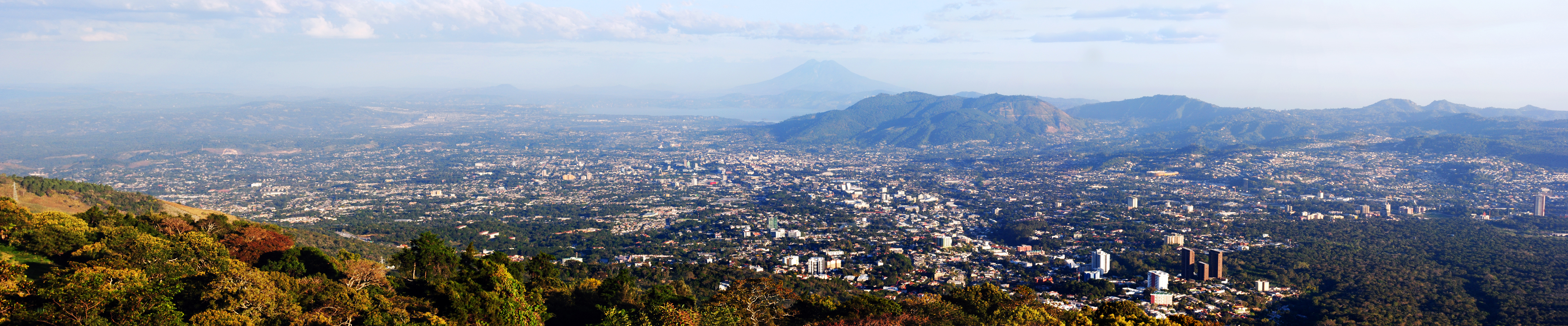
The Metropolitan Area of San Salvador (Área Metropolitana de San Salvador or AMSS) is a metropolitan area formed by San Salvador, the capital of El Salvador, and with a total of seven municipalities which are subdivided into 23 districts. It was instituted in 1993 through Legislative Decree No. 732 of the Law on Territorial Development and the Metropolitan Area of San Salvador and neighbouring municipalities. The Act defines that, based on their urban development, these cities form a single urban unit.
Since 1990, it was felt that urban development in the Municipality of San Salvador and neighbouring municipalities was having a remarkable growth, and even be defined as a big city. This situation required the planning and control of urban development in these municipalities and their conformation as a metropolitan area.
Currently, the AMSS constitutes the directional centre of the country in political, financial, economic and cultural life. The most recently published official population projections for El Salvador forecasted the combined population of the fourteen municipalities at 1,767,102 in 2015, which would constitute 27.4% of the country's projected 6,460,271 inhabitants.
Districts
- San Salvador - Capital of El Salvador.
- Antiguo Cuscatlan - 4 kilometres southwest of San Salvador.
- Santa Tecla - 9 kilometres southwest of San Salvador.
- San Marcos - 6 kilometres south of San Salvador.
- Soyapango - 6 kilometres east of San Salvador.
- Ilopango - 8 kilometres east.
- San Martin - 15 kilometres east.
- Tonacatepeque - 12 kilometres northeast.
- Ciudad Delgado - 4 kilometres northeast.
- Cuscatancingo - 4 kilometres north.
- Mejicanos- 5 kilometres north.
- Apopa - 11 kilometres north.
- Nejapa-13 kilometres north.
- Ayutuxtepeque - 7 kilometres north.
References
References
- (2021). "El Salvador Proyecciones de Población Municipal 2020-2030(rev2021)". Dirección General de Estadística y Censos.
- "Generalidades del AMSS". Consejo de Alcaldes y Oficina de Planificación del Área Metropolitana de San Salvador.
- (September 2014). "El Salvador: Estimaciones y Proyecciones de Población Municipal 2005-2025 (Revisión 2014)". Dirección General de Estadística y Censos.
This article was imported from Wikipedia and is available under the Creative Commons Attribution-ShareAlike 4.0 License. Content has been adapted to SurfDoc format. Original contributors can be found on the article history page.
Ask Mako anything about Metropolitan Area of San Salvador — get instant answers, deeper analysis, and related topics.
Research with MakoFree with your Surf account
Create a free account to save articles, ask Mako questions, and organize your research.
Sign up freeThis content may have been generated or modified by AI. CloudSurf Software LLC is not responsible for the accuracy, completeness, or reliability of AI-generated content. Always verify important information from primary sources.
Report