From Surf Wiki (app.surf) — the open knowledge base
Marown
Parish on the Isle of Man
Parish on the Isle of Man
| Field | Value |
|---|---|
| crown_dependency | Isle of Man |
| official_name | Marown |
| manx_name | Skeerey Varooney |
| coordinates | |
| population | 2,246 |
| population_ref | |
| manx_sheading | Middle |
| constituency_manx_parliament | Middle |
| post_town | ISLE OF MAN |
| postcode_district | IM4 |
| postcode_area | IM |
| map_type | nomap |
| os_grid_reference | SC3265278833 |
| static_image_name | Parish-Marown.svg |
| static_image_width | 175 |
| static_image_caption | Parish of Marown, Isle of Man |
| hide_services | yes |
Marown ( , rhymes with "gown"; ) is one of the seventeen historic parishes of the Isle of Man. It is the only landlocked parish on the Island.
It is located in the centre of the island, in the sheading of Middle, though historically, from 1796 until 1986, it was in the sheading of Glenfaba.
Settlements in the parish include Braaid, Crosby and Glen Vine.
Local government
For the purposes of local government, the whole of the historic parish forms a single parish district with Commissioners.
Although Marown lies east of the watershed and is currently in the sheading of Middle, it is also grouped for various local government purposes with the west of the island: it falls under the aegis of the Peel and Western District Housing Committee, Western Traffic Management Group, Western Neighbourhood Policing etc.
The Captain of the Parish (since 2001) is Charles Fargher MBE.
Politics
Marown parish is part of the Middle constituency, which elects two Members to the House of Keys. Before 1986 it was in the Glenfaba constituency.
Geography
Marown has an area of about 9 sqmi and is the only landlocked parish on the island. The River Dhoo flows through the parish.
Churches, education, historic buildings
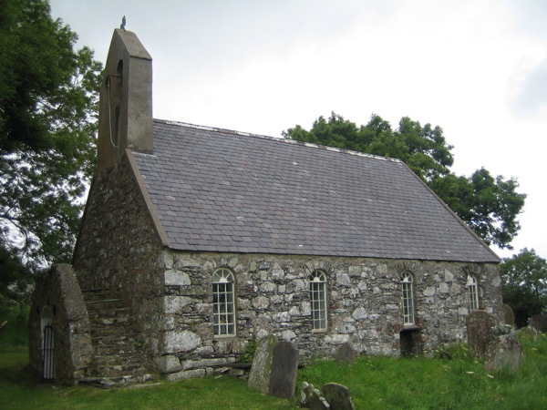
The Church of England parish church is St Runius church in Glen Vine. The old St Runius Church is in Crosby. | access-date = 2008-10-28 | access-date = 2008-10-28 | access-date = 2008-10-28
The parish primary school, Marown Primary School, was built in the 1980s, and is located in Glen Vine. The school was expanded in 2001. |access-date = 2008-10-28 |url-status = dead |archive-url = https://web.archive.org/web/20100110200426/http://www.sch.im/pml/Isle_of_Man_PML_Service/Home.html |archive-date = 2010-01-10
Marown Language Centre (), a foreign language teaching facility and training centre for teachers on the island, is located in Crosby, close to the Old St Runius Church (dedicated to St Runius or Rónán). |access-date=2008-10-28 |url-status=dead |archive-url=https://web.archive.org/web/20080927021526/http://www.sch.im/marown/Site/Marown_School_home_page.html |archive-date=2008-09-27
Historic homes in the parish include Ellerslie Manor, Ballacotch Manor and Ballavagher House.
Roads and footpaths
The Millennium Way long distance footpath runs through the parish, | access-date = 2008-10-28 | access-date = 2008-10-28
Demographics
The Isle of Man census of 2016 returned a parish population of 2,246, a decrease of 2.9% from the figure of 2,311 in 2011. The equivalent figure in the 2021 census was 2,220.
| 1996 |1564 | 2001 |1879 | 2006 |2086 | 2011 |2311 | 2016 |2246 | 2021 |2220
Sport
Marown A.F.C. is a football club who compete in the Isle of Man Football League. They play their home games at the Memorial Playing Fields in Crosby. The village also has the Crosby Cricket Club who play on the same site. They were founded in 1946 and are members of the Isle of Man Cricket Association. |access-date=2008-10-28 |url-status=dead |archive-url=https://web.archive.org/web/20080708190207/http://www.crosbycc.com/clubhistory.htm |archive-date=2008-07-08 | access-date = 2008-10-28 | archive-url = https://web.archive.org/web/20080706134321/http://www.iombadminton.com/glen_vine.htm | archive-date = 6 July 2008 | url-status = dead
References
References
- "2016 Isle of Man Census Report".
- . (1796). ["Common Law Courts Act 1796 (AN ACT for the better Regulation of the Court of Common Law.)"](http://www.legislation.gov.im/cms/images/LEGISLATION/PRINCIPAL/1796/1796-0001/CommonLawCourtsAct1796_1.pdf). *Isle of Man Government*.
- Broderick, George. (2000). "Placenames of the Isle of Man". Niemeyer.
- . ["Marown Parish Commissioners"](http://www.marown.im/).
- "Marown.im".
- . ["Captains of the Parishes"](https://www.culturevannin.im/parishcaptains/captains.html). *Culture Vannin*.
- "Census and Population". Government Isle of Man.
This article was imported from Wikipedia and is available under the Creative Commons Attribution-ShareAlike 4.0 License. Content has been adapted to SurfDoc format. Original contributors can be found on the article history page.
Ask Mako anything about Marown — get instant answers, deeper analysis, and related topics.
Research with MakoFree with your Surf account
Create a free account to save articles, ask Mako questions, and organize your research.
Sign up freeThis content may have been generated or modified by AI. CloudSurf Software LLC is not responsible for the accuracy, completeness, or reliability of AI-generated content. Always verify important information from primary sources.
Report