From Surf Wiki (app.surf) — the open knowledge base
Marion, Kansas
City in Marion County, Kansas
City in Marion County, Kansas
| Field | Value |
|---|---|
| name | Marion, Kansas |
| settlement_type | City and County seat |
| image_skyline | MarionCoCH.JPG |
| image_caption | Marion County Courthouse (2009) |
| image_map | Marion County Kansas Incorporated and Unincorporated areas Marion Highlighted.svg |
| map_caption | Location within Marion County and Kansas |
| image_map1 | Map of Marion Co, Ks, USA.png |
| map_caption1 | KDOT map of Marion County (legend) |
| coordinates_footnotes | |
| coordinates | |
| subdivision_type | Country |
| subdivision_name | United States |
| subdivision_type1 | State |
| subdivision_name1 | Kansas |
| subdivision_type2 | County |
| subdivision_name2 | Marion |
| subdivision_type3 | Township |
| subdivision_name3 | Centre |
| established_title | Founded |
| established_title1 | Platted |
| established_date1 | 1866, 1871, 1873 |
| established_title2 | Incorporated |
| established_date2 | 1875 |
| named_for | Francis Marion |
| government_type | Mayor–Council |
| leader_title | Mayor |
| leader_name | Michael Powers |
| area_footnotes | |
| area_total_sq_mi | 2.70 |
| area_land_sq_mi | 2.69 |
| area_water_sq_mi | 0.01 |
| area_total_km2 | 6.98 |
| area_land_km2 | 6.96 |
| area_water_km2 | 0.02 |
| unit_pref | Imperial |
| elevation_footnotes | |
| elevation_ft | 1342 |
| population_footnotes | |
| population_as_of | 2020 |
| population_total | 1922 |
| population_density_sq_mi | auto |
| population_density_km2 | auto |
| timezone | CST |
| utc_offset | -6 |
| timezone_DST | CDT |
| utc_offset_DST | -5 |
| postal_code_type | ZIP Code |
| postal_code | 66861 |
| area_code_type | Area code |
| area_code | 620 |
| blank_name | FIPS code |
| blank_info | |
| blank1_name | GNIS ID |
| blank1_info | 485619 |
| website |
Marion is a city in and the county seat of Marion County, Kansas, United States. As of the 2020 census, the population of the city was 1,922. The city was named in honor of Francis Marion, a brigadier general of the American Revolutionary War, known as the "Swamp Fox".
History
Early history
For many millennia, the Great Plains of North America was inhabited by Native Americans. From the 16th century to 18th century, the Kingdom of France claimed ownership of large parts of North America. In 1762, after the French and Indian War, France secretly ceded New France to Spain, per the Treaty of Fontainebleau.
19th century
In 1802, Spain returned most of the land to France. In 1803, most of the land for modern day Kansas was acquired by the United States from France as part of the 828,000 square mile Louisiana Purchase for 2.83 cents per acre.
In 1806, Zebulon Pike led the Pike Expedition westward from St Louis, Missouri, of which part of their journey followed the Cottonwood River through Marion County near the current cities of Florence, Marion, Durham.
In 1854, the Kansas Territory was organized, then in 1861 Kansas became the 34th U.S. state. In 1855, Marion County was established within Kansas, which included the land for modern day Marion.
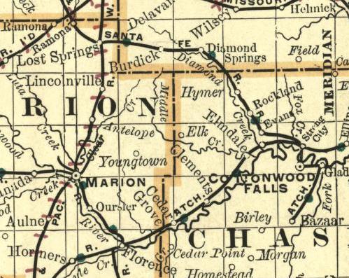
The city of Marion Centre was founded in 1860 and became the county seat, named in honor of Francis Marion. A post office was established on September 30, 1862, which shortened the name to Marion on October 15, 1881. The city officially adopted the shorter name on January 17, 1882. In 1875, Marion incorporated as a city as a 3rd class city, later in 1888 it became a 2nd class city.

As early as 1875, city leaders of Marion held a meeting to consider a branch railroad from Florence. In 1878, Atchison, Topeka and Santa Fe Railway and parties from Marion County and McPherson County chartered the Marion and McPherson Railway Company. In 1879, a branch line was built from Florence to McPherson, in 1880 it was extended to Lyons, in 1881 it was extended to Ellinwood. The line was leased and operated by the Atchison, Topeka and Santa Fe Railway. The line from Florence to Marion, was abandoned in 1968. In 1992, the line from Marion to McPherson was sold to Central Kansas Railway. In 1993, after heavy flood damage, the line from Marion to McPherson was abandoned. The original branch line connected Florence, Marion, Canada, Hillsboro, Lehigh, Canton, Galva, McPherson, Conway, Windom, Little River, Mitchell, Lyons, Chase, and Ellinwood. Later, the Santa Fe depot building was converted into the Marion Library.
In 1887, the Chicago, Kansas and Nebraska Railway built a branch line north-south from Herington through Marion to Caldwell. It foreclosed in 1891 and was taken over by Chicago, Rock Island and Pacific Railway, which shut down in 1980 and reorganized as Oklahoma, Kansas and Texas Railroad, merged in 1988 with Missouri Pacific Railroad, and finally merged in 1997 with Union Pacific Railroad.
In 1889, the Marion Belt and Chingawasa Springs Railroad built a 4.5 mi railroad from Marion north-east to Chingawasa Springs. A hotel was built near the site of the spa at Chingawasa Springs, and a depot and eatery as well. Both Santa Fe and Rock Island offered round trip fares from Chicago and western cities to Chingawasa Springs. An economic panic in 1893 closed down the health spa and hotel, and quarry business along the tracks never developed sufficiently. In 1893, the railroad ceased operations, and tracks were removed in 1910.
20th century
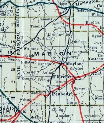
The National Old Trails Road, also known as the Ocean-to-Ocean Highway, was established in 1912, and was routed through Lehigh, Hillsboro, Marion and Lost Springs.
In 1937, the Marion County Lake was completed by the Civilian Conservation Corps south-east of Marion for the purpose of recreation. There were numerous floods during the early history of Marion. In June and July 1951, due to heavy rains, rivers and streams flooded numerous cities in Kansas, including Marion. Many reservoirs and levees were built in Kansas as part of a response to the Great Flood of 1951. From 1964 to 1968, the Marion Reservoir was constructed north-west of Marion. Downstream from the Marion Reservoir, levees were built in the low areas of Marion and Florence.
21st century

2023 newspaper raid
Main article: Marion County Record#2023 police raid
In August 2023, Marion County police raided the newspaper Marion County Record, its owners, and a local city council member. The police had received information that the paper had obtained, allegedly from a confidential source (it was later shown that legal public sources were used) that a local business owner had an unresolved drunk driving conviction and continued to drive for many months without a driving license. The newspaper did not publish this legally obtained information.
Geography
Marion is located in the scenic Flint Hills and Great Plains of the state of Kansas. According to the United States Census Bureau, the city has a total area of 2.99 sqmi, of which 2.98 sqmi is land and 0.01 sqmi is water.
Climate
The climate in this area is characterized by hot, humid summers and generally mild to cool winters. According to the Köppen Climate Classification system, Marion has a humid subtropical climate, abbreviated "Cfa" on climate maps.
|Jan record high F = 74 |Feb record high F = 80 |Mar record high F = 88 |Apr record high F = 95 |May record high F = 98 |Jun record high F = 105 |Jul record high F = 110 |Aug record high F = 109 |Sep record high F = 107 |Oct record high F = 97 |Nov record high F = 83 |Dec record high F = 74
|Jan avg record high F = 62.5 |Feb avg record high F = 68.6 |Mar avg record high F = 77.7 |Apr avg record high F = 84.6 |May avg record high F = 91.2 |Jun avg record high F = 97.3 |Jul avg record high F = 102.5 |Aug avg record high F = 101.1 |Sep avg record high F = 95.9 |Oct avg record high F = 87.8 |Nov avg record high F = 73.6 |Dec avg record high F = 63.9 |year avg record high F = 103.5
|Jan avg record low F = 1.1 |Feb avg record low F = 5.4 |Mar avg record low F = 15.0 |Apr avg record low F = 27.2 |May avg record low F = 38.8 |Jun avg record low F = 51.8 |Jul avg record low F = 57.8 |Aug avg record low F = 56.0 |Sep avg record low F = 42.3 |Oct avg record low F = 28.3 |Nov avg record low F = 17.0 |Dec avg record low F = 7.0 |year avg record low F = -2.5
|Jan record low F = -16 |Feb record low F = -20 |Mar record low F = -5 |Apr record low F = 11 |May record low F = 26 |Jun record low F = 42 |Jul record low F = 46 |Aug record low F = 47 |Sep record low F = 28 |Oct record low F = 14 |Nov record low F = 4 |Dec record low F = -24
|Jan snow depth inch = |Feb snow depth inch = |Mar snow depth inch = |Apr snow depth inch = |May snow depth inch = |Jun snow depth inch = |Jul snow depth inch = |Aug snow depth inch = |Sep snow depth inch = |Oct snow depth inch = |Nov snow depth inch = |Dec snow depth inch = |year snow depth inch =
|access-date = November 21, 2023 |access-date = November 21, 2023
Demographics
|align-fn=center
2020 census
The 2020 United States census counted 1,922 people, 860 households, and 502 families in Marion. The population density was 696.9 per square mile (269.1/km). There were 971 housing units at an average density of 352.1 per square mile (135.9/km). The racial makeup was 94.17% (1,810) white or European American (93.08% non-Hispanic white), 0.1% (2) black or African-American, 0.47% (9) Native American or Alaska Native, 0.05% (1) Asian, 0.0% (0) Pacific Islander or Native Hawaiian, 0.26% (5) from other races, and 4.94% (95) from two or more races. Hispanic or Latino of any race was 3.33% (64) of the population.
Of the 860 households, 23.8% had children under the age of 18; 46.4% were married couples living together; 29.8% had a female householder with no spouse or partner present. 37.7% of households consisted of individuals and 21.3% had someone living alone who was 65 years of age or older. The percent of those with a bachelor’s degree or higher was estimated to be 18.4% of the population.
20.3% of the population was under the age of 18, 7.8% from 18 to 24, 20.9% from 25 to 44, 26.3% from 45 to 64, and 24.7% who were 65 years of age or older. The median age was 46.3 years. For every 100 females, there were 114.0 males. For every 100 females ages 18 and older, there were 117.8 males.
The 2016-2020 5-year American Community Survey estimates show that the median household income was $46,548 (with a margin of error of +/- $5,836) and the median family income was $59,028 (+/- $9,025). Males had a median income of $40,000 (+/- $11,143) versus $28,750 (+/- $8,663) for females. The median income for those above 16 years old was $32,826 (+/- $3,144). Approximately, 5.2% of families and 5.5% of the population were below the poverty line, including 4.9% of those under the age of 18 and 4.2% of those ages 65 or over.
2010 census
At the 2010 census, there were 1,927 people, 846 households, and 514 families residing in the city. The population density was 646.6 /sqmi. There were 973 housing units at an average density of 326.5 /sqmi. The racial makeup of the city was 97.6% White, 0.6% African American, 0.3% Native American, 0.1% Asian, 0.1% Pacific Islander, 0.5% from other races, and 0.8% from two or more races. Hispanic or Latino of any race were 1.4% of the population.
There were 846 households, of which 28.6% had children under the age of 18 living with them, 47.3% were married couples living together, 9.6% had a female householder with no husband present, 3.9% had a male householder with no wife present, and 39.2% were non-families. 36.2% of all households were made up of individuals, and 19.5% had someone living alone who was 65 years of age or older. The average household size was 2.23 and the average family size was 2.90.
The median age was 44 years. 24.3% of residents were under the age of 18; 6.6% were between the ages of 18 and 24; 20.5% were from 25 to 44; 25.6% were from 45 to 64; and 23% were 65 years of age or older. The gender makeup was 47.5% male and 52.5% female.
Arts and culture
Area events
- Chingawassa Days Festival
- Old Settler's Day
- Art in the Park and Craft Show
Area attractions

Marion has five listings on the National Register of Historic Places (NRHP).
- Elgin Hotel (NRHP), 115 North 3rd Street. Currently a Bed and Breakfast.
- First Presbyterian Church (NRHP), 610 East Lawrence Street.
- Hill Grade School (NRHP), 601 East Main Street.
- Marion County Courthouse (NRHP), 200 South 3rd Street.
- Marion County Museum, 623 East Main Street. Formerly the First Baptist Church from 1882 to mid-1950s. Nearby recreational areas:
- Marion County Lake, southeast of Marion, 1 mi east of Marion on 190th Street (Main) then 1.75 mi south on Upland Road.
- Marion Reservoir, northwest of Marion, exists along US-56 (closest to farthest): Marion cove and Cottonwood Point cove (Pawnee Road), Overlook and Dam (Old Mill Road), Hillsboro cove (Nighthawk Road), French Creek cove (Limestone Road).
Government

City
The Marion government consists of a mayor and four council members. The city council meets every other Monday at 4:30pm.
- City Hall – 208 E. Santa Fe St.
- Police Department – 112 N. 5th St. As of August 2023, the police department had five full time members.
- Fire Department – 114 N. 5th St.
County
- Marion County Courthouse – 203 S. 4th St.
U.S.
- U.S. Post Office – 423 E. Main St.
- U.S. Consolidated Farm Service Agency – 301 N. Eisenhower Dr.
Education


Public schools
The community is served by Marion–Florence USD 408 public school district. The high school is a member of T.E.E.N., a shared video teaching network between five area high schools.
- Marion High School (Kansas), 701 E Main St.
- Marion Middle School, 125 S Lincoln St.
- Marion Elementary School, 1400 E Lawrence St.
Library
Each USD 408 school has a library for student access. The city is served by the Marion City Library at 101 Library Street. The library is a member of the North Central Kansas Libraries System, which provides an inter-library book loan service between its members.
Media
- Marion County Record, official newspaper for City of Marion and Marion County.
- Hillsboro Free Press, free newspaper for greater Marion County area.
Radio
Marion is served by numerous radio stations from the Wichita-Hutchinson listening market area, and satellite radio. (See Media in Wichita, Kansas.)
Television
Marion is served by over-the-air ATSC digital TV of the Wichita-Hutchinson viewing market area, cable TV, and satellite TV. (See Media in Wichita, Kansas.)
Infrastructure
Transportation
U.S. Route 56 runs along the city's northern side, and U.S. Route 77 is 2 mi east of the city. Kansas Highway 256 runs through the center of town as Main Street, past the east end business section, Marion High School and the downtown business district. A regional Kansas Department of Transportation office is located on the northern side of Marion at the corner of U.S. Route 56 and Cedar Street.
The Oklahoma Kansas Texas (OKT) line of the Union Pacific Railroad runs north-south through the city. The Chicago, Rock Island and Pacific Railroad's Kansas City Rocket formerly provided passenger rail service to Marion on their Mid-Continent Route until at least 1963. As of 2025, the nearest passenger rail station is located in Newton, where Amtrak's Southwest Chief stops once daily on a route from Chicago to Los Angeles.
The Atchison, Topeka and Santa Fe also previously provided passenger and freight rail service to Marion. A brick depot was built in June 1912, which now stands as the city library.
Marion Municipal Airport, FAA:43K, is located south-east of Marion and centered at .
Notable people

- Randolph Carpenter (1894–1956), U.S. Representative from Kansas and a U.S. Army World War I veteran.
- Charlie Faust (1880–1915), Major League baseball player
- Beverly Hoch (born 1951), soprano
- Edward Hoch (1849–1925), Kansas House of Representatives, 17th Governor of Kansas, editor of Marion County Record, Hoch Auditoria at University of Kansas was named after him.
- Homer Hoch (1879–1949), U.S. Congressman, member of Kansas Supreme Court, lawyer, editor of Marion County Record
- Tex Jones (1885–1938), Major League baseball player
- Eric Meyer (born 1953), journalism professor at University of Illinois, Pulitzer Prize nominee, president and majority owner of Hoch Publishing Co (in Marion)
- Fay Moulton (1876–1945), Olympic sprinter, football player and coach, lawyer; served as fifth head football coach at Kansas State Agricultural College (Kansas State University)
- Samuel Peters (1842–1910), Captain in Union Army (1861–1865), lawyer, Kansas State Senator (1874–1875), Judge of 9th District (1875–1883), U.S. House of Representatives (1883–1891), newspaper editor
- William Runyan (1870–1957), preacher, composer of "Great Is Thy Faithfulness"
- Carla Stovall (born 1957), Kansas Attorney General If you add/edit this section, it is YOUR responsibility to ensure ALL of the following is met:
- You MUST insert each person into the list, sorted/ordered by last name (surname).
- Each person MUST meet the Wikipedia:Notability (people) guideline.
- If a person has a Wikipedia article, then you MUST wikilink the persons name to the correct wikipedia article. Their wikipedia article MUST state the person has resided in this city.
- If a person doesn't have a Wikipedia article, then you MUST add a citation reference (Wikipedia:Citing sources) to prove notability (Wikipedia:Notability (people)) and the reference MUST state the person has resided in this city (Wikipedia:Verifiability).
- END OF INSTRUCTIONS *** --
References
References
- "2019 U.S. Gazetteer Files". United States Census Bureau.
- {{cite gnis2. 485619. Marion, Kansas
- "Profile of Marion, Kansas in 2020". United States Census Bureau.
- "Blue Skyways – A service of the State Library of Kansas".
- "1806 Pike Expedition map through Marion County". zebulonpike.org.
- "The History of Marion County and Courthouse".
- Kansas State Historical Society. (1916). "Biennial Report of the Board of Directors of the Kansas State Historical Society". Kansas State Printing Plant.
- "Kansas Post Offices, 1828–1961 (archived)". Kansas Historical Society.
- ''Marion County Kansas : Past and Present''; Sondra Van Meter; MB Publishing House; [[LCCN]] 72-92041; 344 pages; 1972.
- (August 13, 1886). "Fourth Annual Report of the Board of Railroad Commissioners for the Year Ending December 1, 1886 in State of Kansas; Kansas Publishing House; 1886.".
- "Lyons to Florence, KS - Abandoned Rails".
- "Rock Island Rail History".
- "The Marion Belt and Chingawasa Springs Railroad".
- "Chingawasa Springs (1 of 2)". National Orphan Train Complex.
- (August 11, 2023). "Police stage 'chilling' raid on Marion County newspaper, seizing computers, records and cellphones". [[Kansas Reflector]].
- (August 13, 2023). "A central Kansas police force sparked a firestorm by raiding a newspaper and the publisher's home".
- "Police seized phone, computer from town official the same day as Kansas newspaper raid".
- "US Gazetteer files 2010". [[United States Census Bureau]].
- "Climate Summary for Marion, Kansas". Weatherbase.
- "US Census Bureau, Table P16: HOUSEHOLD TYPE".
- "US Census Bureau, Table DP1: PROFILE OF GENERAL POPULATION AND HOUSING CHARACTERISTICS".
- "Gazetteer Files". United States Census Bureau.
- "US Census Bureau, Table P1: RACE".
- "US Census Bureau, Table P2: HISPANIC OR LATINO, AND NOT HISPANIC OR LATINO BY RACE".
- "US Census Bureau, Table S1501: EDUCATIONAL ATTAINMENT".
- "US Census Bureau, Table S1903: MEDIAN INCOME IN THE PAST 12 MONTHS (IN 2020 INFLATION-ADJUSTED DOLLARS)".
- "US Census Bureau, Table S2001: EARNINGS IN THE PAST 12 MONTHS (IN 2020 INFLATION-ADJUSTED DOLLARS)".
- "US Census Bureau, Table S1701: POVERTY STATUS IN THE PAST 12 MONTHS".
- "US Census Bureau, Table S1702: POVERTY STATUS IN THE PAST 12 MONTHS OF FAMILIES".
- "U.S. Census website". [[United States Census Bureau]].
- "Chingawassa Days Festival 2012". chingawassa.com.
- "City of Marion Official web site".
- "City of Marion Official web site".
- "marionelgin.com".
- "Elgin Hotel". National Register of Historic Places.
- "First Presbyterian Church". National Register of Historic Places.
- "Hill Grade School". National Register of Historic Places.
- "Marion County, KS |".
- "Marion County Courthouse". National Register of Historic Places.
- "City of Marion Official web site".
- "City Council".
- "Police Department".
- "Fire Department".
- "T.E.E.N. video teaching network". teen632.
- "Marion City Library".
- "Wichita-Hutchinson Radio market.".
- "Wichita - Hutchinson Television Stations - Station Index".
- "UP Railroad Common Line Names". [[Union Pacific Railroad]].
- "Rock Island 1963 Timetable".
- "Amtrak Southwest Chief".
- (July 12, 2025). "Marion Library sign".
- (June 10, 2016). "Marion Municipal Airport map".
- "AirNav: 43K - Marion Municipal Airport".
- (May 7, 1983). "13 Advance to Semi-finals". [[The Victoria Advocate]].
- "Kansas Legislators Past & Present". kslib.info.
- Capace, Nancy. (June 1, 2000). "Encyclopedia of Kansas". North American Book Dist LLC.
- "Meyer, Eric {{!}} Kansas Press Association".
This article was imported from Wikipedia and is available under the Creative Commons Attribution-ShareAlike 4.0 License. Content has been adapted to SurfDoc format. Original contributors can be found on the article history page.
Ask Mako anything about Marion, Kansas — get instant answers, deeper analysis, and related topics.
Research with MakoFree with your Surf account
Create a free account to save articles, ask Mako questions, and organize your research.
Sign up freeThis content may have been generated or modified by AI. CloudSurf Software LLC is not responsible for the accuracy, completeness, or reliability of AI-generated content. Always verify important information from primary sources.
Report