From Surf Wiki (app.surf) — the open knowledge base
Main (river)
River in Germany

River in Germany
| Field | Value |
|---|---|
| name | Main |
| image | Würzburg Löwenbrücke.jpg |
| image_caption | The Main River in Würzburg |
| map | Main-Karte-160710.jpg |
| map_caption | Position of the Main in Germany |
| map_size | 300 |
| mapframe | yes |
| mapframe-zoom | 6 |
| source1_location | Upper Franconia |
| source1_coordinates | |
| source1_elevation | 895 metres (at Weissmainquelle) |
| mouth_location | Rhine |
| mouth_coordinates | |
| mouth_elevation | 83 m |
| progression | |
| subdivision_type1 | Country |
| subdivision_name1 | Germany |
| length | 524.9 km |
| discharge1_avg | 200 m3/s |
| basin_size | 27208 km2 |
| subdivision_type2 | States |
| state | Hesse |
| mapframe-zoom = 6 Bavaria Baden-Württemberg
The Main () is the longest tributary of the Rhine, one of the major European rivers. It rises as the White Main in the Fichtel Mountains of northeastern Bavaria and flows west through central Germany for 525 km to meet the Rhine below Rüsselsheim, Hesse. The cities of Mainz and Wiesbaden are close to the confluence.
The largest cities on the Main are Frankfurt am Main, Offenbach am Main and Würzburg. It is the longest river lying entirely in Germany (if the Weser-Werra are considered separate).
Geography
The Main flows through the north and north-west of the state of Bavaria and then across southern Hesse; against the latter it demarcates a third state, Baden-Württemberg, east and west of Wertheim am Main, the northernmost town of that state.
The upper end of its basin opposes that of the Danube where the watershed is recognised by natural biologists, sea salinity studies (and hydrology science more broadly) as the European Watershed.
The Main begins near Kulmbach in Franconia at the joining of its two headstreams, the Red Main (Roter Main) and the White Main (Weißer Main). The Red Main originates in the Franconian Jura mountain range, 50 km in length, and runs through Creussen and Bayreuth. The White Main originates in the Fichtel Mountains; it is 41 km long. In its upper and middle section, the Main runs through the valleys of the German Highlands. Its lower section crosses the Lower Main Lowlands (Hanau-Seligenstadt Basin and northern Upper Rhine Plain) to Wiesbaden, where it discharges into the Rhine. Major tributaries of the Main are the Regnitz, the Franconian Saale, the Tauber, and the Nidda.
The name Main originates from Latin Moenis, Moenus or Menus. It is not related to the name of the city Mainz (Latin: Mogontiacum or Moguntiacum).
Navigation
The Main is navigable for shipping from its mouth at the Rhine close to Mainz for 396 km to Bamberg. Since 1992, the Main has been connected to the Danube via the Rhine-Main-Danube Canal and the highly regulated Altmühl river. The Main has been canalized with 34 large locks (300 xx) to allow CEMT class V vessels (110 xx) to navigate the total length of the river. The 16 locks in the adjacent Rhine-Main-Danube Canal and the Danube itself are of the same dimensions.
Weirs and locks
There are 34 weirs and locks along the 380 km navigable portion of the Main, from the confluence with the Regnitz near Bamberg, to the Rhine.
- No.: Number of the lock (from upstream to downstream).
- Name: Name of the lock.
- Location: City or town where the lock is located.
- Year built: Year when the lock was put into operation (replacement dates are also listed where applicable).
- Main-km: Location on the Main, measured from the 0 km stone in Mainz-Kostheim. The reference point is the center of the lock or lock group.
- Distance between locks: length in km of impoundment (between adjacent locks).
- Altitude: Height in meters above mean sea level of the upper water at normal levels.
- Height: Height of the dam in meters (the height of the Kostheim lock depends on the water level of the Rhine).
- Lock length: Usable length of the lock chamber in meters.
- Lock width: Usable width of the lock chamber in meters.
| No. | Name | Location | Year built | Main-km | Distance between locks (km) | Altitude (m) | Height (m) | Lock length (m) | Lock width (m) |
|---|---|---|---|---|---|---|---|---|---|
| 1 | Viereth | Viereth-Trunstadt | 1925 | 380.699 | 230.86 | 6.00 | 289.80 | 12.00 | |
| 2 | Limbach | Eltmann | 1951 | 367.176 | 224.86 | 5.36 | 299.10 | 12.00 | |
| 3 | Knetzgau | Knetzgau (Haßfurt) | 1958 | 359.781 | 219.50 | 4.24 | 298.85 | 12.00 | |
| 4 | Ottendorf | Gädheim | 1962 | 345.263 | 215.26 | 7.59 | 301.60 | 12.00 | |
| 5 | Schweinfurt | Schweinfurt | 1963 | 332.037 | 207.67 | 4.67 | 300.60 | 12.00 | |
| 6 | Garstadt | Bergrheinfeld | 1956 | 323.503 | 203.00 | 4.69 | 299.75 | 12.00 | |
| 7 | Wipfeld | Wipfeld | 1950 | 316.289 | 198.31 | 4.31 | 300.15 | 12.00 | |
| 8 | Gerlachshausen mit Volkach | Volkach (Schwarzach am Main) | 1957 | 300.506 | 194.00 | 6.30 | 300.00 | 12.00 | |
| 9 | Dettelbach | Dettelbach | 1959 | 295.398 | 187.70 | 5.50 | 299.35 | 12.00 | |
| 10 | Kitzingen | Kitzingen | 1956 | 283.979 | 182.20 | 3.66 | 299.80 | 12.00 | |
| 11 | Marktbreit | Marktbreit (Frickenhausen am Main) | 1955 | 275.681 | 178.54 | 3.31 | 296.40 | 12.00 | |
| 12 | Goßmannsdorf | Ochsenfurt | 1952 | 269.028 | 175.23 | 3.40 | 296.90 | 12.00 | |
| 13 | Randersacker | Würzburg (Randersacker) | 1950 | 258.885 | 171.83 | 3.30 | 299.60 | 12.00 | |
| 14 | Würzburg | Würzburg | 1954 | 252.512 | 168.53 | 2.75 | 293.10 | 12.00 | |
| 15 | Erlabrunn | Erlabrunn (Thüngersheim) | 1935 | 241.204 | 165.78 | 4.15 | 299.20 | 12.00 | |
| 16 | Himmelstadt | Himmelstadt | 1939 | 232.290 | 161.63 | 4.30 | 299.50 | 12.00 | |
| 17 | Harrbach | Karlstadt (Gemünden am Main) | 1939 | 219.466 | 157.33 | 4.90 | 299.45 | 12.00 | |
| 18 | Steinbach | Lohr am Main | 1939 | 200.673 | 152.43 | 5.14 | 299.10 | 12.00 | |
| 19 | Rothenfels | Rothenfels (Marktheidenfeld) | 1937 | 185.887 | 147.29 | 5.26 | 298.45 | 12.00 | |
| 20 | Lengfurt | Triefenstein | 1937 | 174.508 | 142.03 | 3.99 | 300.08 | 11.98 | |
| 21 | Eichel | Wertheim | 1937 | 160.467 | 138.04 | 4.50 | 299.92 | 12.00 | |
| 22 | Faulbach | Wertheim (Faulbach) | 1935 | 147.065 | 133.54 | 4.51 | 299.80 | 12.10 | |
| 23 | Freudenberg | Collenberg (Freudenberg) | 1934 | 133.948 | 129.03 | 4.51 | 300.00 | 12.00 | |
| 24 | Heubach | Großheubach (Miltenberg) | 1932 | 122.360 | 124.52 | 4.00 | 300.00 | 12.00 | |
| 25 | Klingenberg | Klingenberg am Main | 1930 | 113.050 | 120.52 | 4.00 | 300.71 | 12.05 | |
| 26 | Wallstadt | Kleinwallstadt (Großwallstadt) | 1930 | 101.203 | 116.52 | 4.00 | 299.93 | 12.00 | |
| 27 | Obernau | Niedernberg (Aschaffenburg) | 1930 | 92.909 | 112.52 | 4.01 | 299.18 | 12.00 | |
| 28 | Kleinostheim | Kleinostheim (Stockstadt am Main) | 1920 | ||||||
| 1972 | 77.905 | 108.51 | 6.80 | 298.36 | |||||
| 298.22 | 12.04 | ||||||||
| 12.02 | |||||||||
| 29 | Krotzenburg | Hainburg (Großkrotzenburg) | 1920 | ||||||
| 1983 | 63.850 | 101.71 | 2.74 | 302.30 | |||||
| 300.01 | 12.00 | ||||||||
| 12.00 | |||||||||
| 30 | Mühlheim | ||||||||
| (formerly Kesselstadt) | Maintal (Mühlheim am Main) | 1920 | |||||||
| 1980 | 53.185 | 98.97 | 3.77 | 299.90 | 12.04 | ||||
| 31 | Offenbach | Frankfurt am Main (Offenbach am Main) | 1901 | ||||||
| 1957 | 38.514 | 95.20 | 3.18 | 344.03 | |||||
| 230.07 | 12.09 | ||||||||
| 13.05 | |||||||||
| 32 | Griesheim | Frankfurt am Main | 1934 | 28.687 | 92.02 | 4.49 | 344.05 | ||
| 344.38 | 12.00 | ||||||||
| 15.00 | |||||||||
| 33 | Eddersheim | Hattersheim am Main (Kelsterbach) | 1934 | 15.551 | 87.53 | 3.61 | 345.46 | ||
| 344.26 | 12.05 | ||||||||
| 15.05 | |||||||||
| 34 | Kostheim | Hochheim am Main (Ginsheim-Gustavsburg) | 1886 | ||||||
| 1934 | 3.209 | 83.92 | |||||||
| 2.36 | |||||||||
| (MW Rhine) | 341.90 | ||||||||
| 339.02 | 15.00 | ||||||||
| Door: 12.00 | |||||||||
| Chamber: 20.00 |
Hydroelectric power generation
Most of the weirs or dams along the Main also have turbines for power generation.
- No.: Number of the dam/weir (from upstream to downstream).
- Name: Name of the dam/weir.
- Height: Height of the dam/weir in meters (the height of the Kostheim dam depends on the water level of the Rhine).
- Power: Maximum power generation capacity in megawatts.
- Turbines: Type and number of turbines.
- Operator: Operator of the hydroelectric plant.
| No. | Name | Height (m) | Power (MW) | Turbines | Operator |
|---|---|---|---|---|---|
| 1 | Viereth | 6.00 | 6.20 | Francis(3), Kaplan(1) | E.ON Wasserkraft |
| 2 | Limbach | 5.36 | 3.70 | Kaplan(2) | E.ON Wasserkraft |
| 3 | Knetzgau | 4.24 | 2.90 | Kaplan(2) | E.ON Wasserkraft |
| 4 | Ottendorf | 7.59 | 6.30 | Kaplan(2) | E.ON Wasserkraft |
| 5 | Schweinfurt | 4.67 | 3.80 | Kaplan(2) | E.ON Wasserkraft |
| 6 | Garstadt | 4.69 | 3.90 | Kaplan(2) | E.ON Wasserkraft |
| 7 | Wipfeld | 4.31 | 2.90 | Kaplan(2) | E.ON Wasserkraft |
| 8 | Gerlachshausen mit Volkach | 6.30 | 3.90 | Kaplan(2) | E.ON Wasserkraft |
| 9 | Dettelbach | 5.50 | 4.20 | Kaplan(2) | E.ON Wasserkraft |
| 10 | Kitzingen | 3.66 | 3.00 | Kaplan(2) | E.ON Wasserkraft |
| 11 | Marktbreit | 3.31 | 2.10 | Kaplan(2) | E.ON Wasserkraft |
| 12 | Goßmannsdorf | 3.40 | 2.00 | Kaplan(2) | E.ON Wasserkraft |
| 13 | Randersacker | 3.30 | 2.00 | Kaplan(2) | E.ON Wasserkraft |
| 14 | Würzburg | 2.75 | 0.90 | Kaplan(3) | E.ON Wasserkraft |
| 15 | Erlabrunn | 4.15 | 2.70 | Kaplan(1) | E.ON Wasserkraft |
| 16 | Himmelstadt | 4.30 | 2.50 | Kaplan(1) | E.ON Wasserkraft |
| 17 | Harrbach | 4.90 | 3.00 | Kaplan(2) | E.ON Wasserkraft |
| 18 | Steinbach | 5.14 | 4.20 | Kaplan(2) | E.ON Wasserkraft |
| 19 | Rothenfels | 5.26 | 4.20 | Kaplan(2) | E.ON Wasserkraft |
| 20 | Lengfurt | 3.99 | 2.60 | E.ON Wasserkraft | |
| 21 | Eichel | 4.50 | 3.10 | E.ON Wasserkraft | |
| 22 | Faulbach | 4.51 | 4.10 | E.ON Wasserkraft | |
| 23 | Freudenberg | 4.51 | 4.30 | E.ON Wasserkraft | |
| 24 | Heubach | 4.00 | 3.40 | E.ON Wasserkraft | |
| 25 | Klingenberg | 4.00 | 3.00 | E.ON Wasserkraft | |
| 26 | Wallstadt | 4.00 | 3.40 | E.ON Wasserkraft | |
| 27 | Obernau | 4.01 | 3.20 | E.ON Wasserkraft | |
| 28 | Kleinostheim | 6.80 | 9.70 | E.ON Wasserkraft | |
| 29 | Krotzenburg | 2.74 | |||
| 30 | Mühlheim | 3.77 | 4.80 | E.ON Wasserkraft | |
| 31 | Offenbach | 3.18 | 4.10 | E.ON Wasserkraft | |
| 32 | Griesheim | 4.49 | 4.90 | Kaplan(3) | Wasser- und Schifffahrtsamt Aschaffenburg |
| 33 | Eddersheim | 3.61 | 3.84 | Kaplan(3) | Wasser- und Schifffahrtsamt Aschaffenburg |
| 34 | Kostheim | 2.36 | 4.9 | Kaplan Pit-Rohrturbinen(2) | WKW Staustufe Kostheim/Main GmbH & Co. KG (Gebaut und Betrieben von Stadtwerke Ulm/Neu-Ulm) |
Tributaries
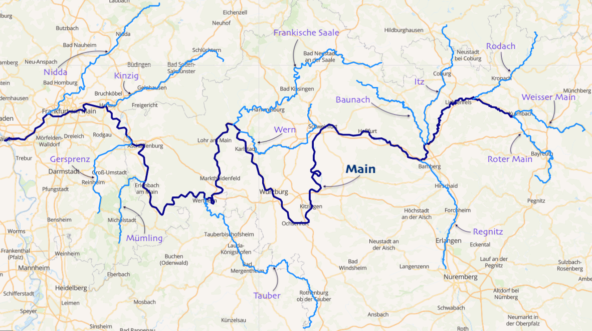
Tributaries from source to mouth: Left
- Regnitz
- Tauber
- Mümling Right
- Rodach (Main)
- Itz
- Franconian Saale
- Aschaff
- Kahl
- Kinzig
- Nidda File:Mainfest Frankfurt.jpg|The Main in Frankfurt at night Image:Offenbach 4.jpg|The Main in Offenbach am Main Image:Mainspitze fg01.JPG|Confluence into the Rhine at Mainz-Kostheim
Ports and municipalities
Around Frankfurt are several large inland ports. Because the river is rather narrow on many of the upper reaches, navigation with larger vessels and push convoys requires great skill.
The largest cities along the Main are Frankfurt am Main, Offenbach am Main and Würzburg. The Main also passes the following towns: Burgkunstadt, Lichtenfels, Bad Staffelstein, Eltmann, Haßfurt, Schweinfurt, Volkach, Kitzingen, Marktbreit, Ochsenfurt, Karlstadt, Gemünden, Lohr, Marktheidenfeld, Wertheim, Miltenberg, Obernburg, Erlenbach/Main, Aschaffenburg, Seligenstadt, Hainburg, Hanau, Hattersheim, Flörsheim, and Rüsselsheim.
The river has gained enormous importance as a vital part of European "Corridor VII", the inland waterway link from the North Sea to the Black Sea.
Main line
Main article: Main line (political)
In a historical and political sense, the Main line is referred to as the northern border of Southern Germany, with its predominantly Catholic population. The river roughly marked the southern border of the North German Federation, established in 1867 under Prussian leadership as the predecessor of the German Empire.
The river course also corresponds with the Speyer line isogloss between Central and Upper German dialects, sometimes mocked as Weißwurstäquator.
Recreation
The Main-Radweg is a major German bicycle path alongside the river. Approximately 600 km, it is the first long-distance instance awarded 5 stars by the General German Bicycle Club (ADFC) in 2008. It starts from Creußen or Bischofsgrün and ends in Mainz.
Sights
- Roman camp at Marktbreit
Bibliography
- Haus der Bayerischen Geschichte (ed.). Main und Meer: Porträt eines Flusses . Exhibition Catalogue to the Bayerische Landesausstellung 2013 (German). WBG. .
References
- "Main River {{!}} river, Germany".
- (2009). "Rivers of Europe". Academic Press.
- (June 2003). "Daten und Fakten". Wasser- und Schifffahrtsdirektion Süd.
- "NoorderSoft Waterways Database".
- (12 May 2014). "From St Jerome to Hypertext: Translation in Theory and Practice". Routledge.
- (11 April 2013). "Dictionary of Contemporary Germany". Routledge.
- "Main-Radweg".
This article was imported from Wikipedia and is available under the Creative Commons Attribution-ShareAlike 4.0 License. Content has been adapted to SurfDoc format. Original contributors can be found on the article history page.
Ask Mako anything about Main (river) — get instant answers, deeper analysis, and related topics.
Research with MakoFree with your Surf account
Create a free account to save articles, ask Mako questions, and organize your research.
Sign up freeThis content may have been generated or modified by AI. CloudSurf Software LLC is not responsible for the accuracy, completeness, or reliability of AI-generated content. Always verify important information from primary sources.
Report