From Surf Wiki (app.surf) — the open knowledge base
Mahoning Township, Armstrong County, Pennsylvania
Township in Pennsylvania, US
Township in Pennsylvania, US
| Field | Value |
|---|---|
| official_name | Mahoning Township, |
| Armstrong County, Pennsylvania | |
| settlement_type | Township |
| image_skyline | Bridge between Madison and Mahoning Townships.jpg |
| imagesize | 250px |
| image_caption | The historic bridge between Madison and Mahoning Townships |
| image_map | Map of Mahoning Township, Armstrong County, Pennsylvania Highlighted.png |
| mapsize | 250x200px |
| map_caption | Map of Armstrong County, Pennsylvania, highlighting Mahoning Township |
| image_map1 | Map of Pennsylvania highlighting Armstrong County.svg |
| mapsize1 | 250x200px |
| map_caption1 | Map of Armstrong County, Pennsylvania |
| subdivision_type | Country |
| subdivision_name | United States |
| subdivision_type1 | State |
| subdivision_name1 | Pennsylvania |
| subdivision_type2 | County |
| subdivision_name2 | Armstrong |
| established_title | Settled |
| established_date | 1787 |
| established_title1 | Incorporated |
| established_date1 | 1851 |
| unit_pref | Imperial |
| area_footnotes | |
| area_total_km2 | 65.32 |
| area_land_km2 | 64.19 |
| area_water_km2 | 1.13 |
| area_total_sq_mi | 25.22 |
| area_land_sq_mi | 24.78 |
| area_water_sq_mi | 0.44 |
| population_as_of | 2020 |
| population_total | 1406 |
| population_density_km2 | 21.16 |
| population_density_sq_mi | 54.80 |
| timezone | Eastern (EST) |
| utc_offset | -5 |
| timezone_DST | EDT |
| utc_offset_DST | -4 |
| pop_est_as_of | 2021 |
| pop_est_footnotes | |
| population_est | 1393 |
| blank_name | FIPS code |
| blank_info | 42-005-46632 |
Armstrong County, Pennsylvania Mahoning Township is a township in Armstrong County, Pennsylvania, United States. The population was 1,406 at the 2020 census, a decrease from 1,425 at the 2010 census.
History
The bridge between Madison and Mahoning Townships and Colwell Cut Viaduct are listed on the National Register of Historic Places.
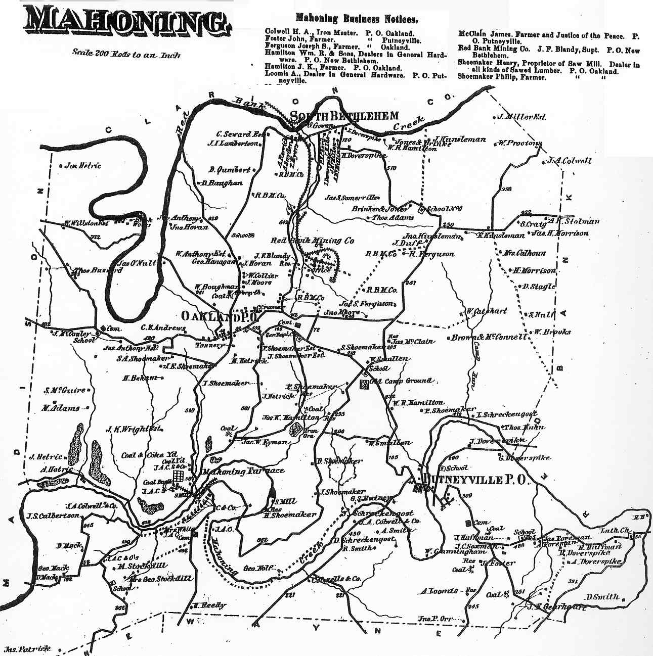
Mahoning Township appears in the 1876 Atlas of Armstrong County, Pennsylvania. Its early history is detailed in Robert Walter Smith's 1883 History of Armstrong County.
Geography
Mahoning Township is located along the northern border of Armstrong County and is bordered by Clarion County to the north across the river.
According to the United States Census Bureau, the township has a total area of 65.3 sqkm, of which 64.2 sqkm is land and 1.1 sqkm, or 1.73%, is water.
Climate
According to the Köppen Climate Classification system, has a warm-summer humid continental climate, abbreviated "Dfb" on climate maps. The hottest temperature recorded at Putneyville Dam was 103 F on July 17, 1988, while the coldest temperature recorded was -22 F on January 20, 1994, and February 25, 2015.
|Jan record high F = 73 |Feb record high F = 73 |Mar record high F = 84 |Apr record high F = 90 |May record high F = 92 |Jun record high F = 100 |Jul record high F = 103 |Aug record high F = 99 |Sep record high F = 96 |Oct record high F = 88 |Nov record high F = 80 |Dec record high F = 73
|Jan avg record high F = 58.3 |Feb avg record high F = 59.8 |Mar avg record high F = 70.8 |Apr avg record high F = 80.5 |May avg record high F = 86.1 |Jun avg record high F = 88.9 |Jul avg record high F = 90.7 |Aug avg record high F = 89.4 |Sep avg record high F = 86.9 |Oct avg record high F = 79.5 |Nov avg record high F = 69.1 |Dec avg record high F = 59.9 |year avg record high F = 92.2
|Jan avg record low F = -3.8 |Feb avg record low F = -0.6 |Mar avg record low F = 4.8 |Apr avg record low F = 20.2 |May avg record low F = 29.2 |Jun avg record low F = 38.8 |Jul avg record low F = 45.7 |Aug avg record low F = 44.5 |Sep avg record low F = 36.9 |Oct avg record low F = 27.0 |Nov avg record low F = 15.8 |Dec avg record low F = 7.0 |year avg record low F = -6.7
|Jan record low F = -22 |Feb record low F = -22 |Mar record low F = -12 |Apr record low F = 11 |May record low F = 17 |Jun record low F = 28 |Jul record low F = 36 |Aug record low F = 31 |Sep record low F = 22 |Oct record low F = 15 |Nov record low F = -2 |Dec record low F = -19
|Jan snow depth inch = 6.9 |Feb snow depth inch = 6.4 |Mar snow depth inch = 4.6 |Apr snow depth inch = 0.2 |May snow depth inch = 0.0 |Jun snow depth inch = 0.0 |Jul snow depth inch = 0.0 |Aug snow depth inch = 0.0 |Sep snow depth inch = 0.0 |Oct snow depth inch = 0.0 |Nov snow depth inch = 1.3 |Dec snow depth inch = 3.5 |year snow depth inch = 9.7
|access-date = August 7, 2023 |access-date = August 7, 2023
Recreation
Pennsylvania State Game Lands Number 137 is located in the northern portion of Mahoning Township, just outside of South Bethlehem near Redbank Creek.
Demographics
As of the 2000 census, there were 1,502 people, 607 households, and 449 families residing in the township. The population density was 60.5 PD/sqmi. There were 667 housing units at an average density of 26.8 /sqmi. The racial makeup of the township was 99.20% White, 0.27% African American, 0.07% Native American, 0.07% Pacific Islander, and 0.40% from two or more races.
There were 607 households, out of which 30.1% had children under the age of 18 living with them, 63.8% were married couples living together, 6.4% had a female householder with no husband present, and 26.0% were non-families. 22.7% of all households were made up of individuals, and 12.0% had someone living alone who was 65 years of age or older. The average household size was 2.47 and the average family size was 2.90.
The township median age of 40 years was the same as the county median age of 40 years. The distribution by age group was 23.8% under the age of 18, 8.2% from 18 to 24, 25.4% from 25 to 44, 25.0% from 45 to 64, and 17.5% who were 65 years of age or older. The median age was 40 years. For every 100 females there were 97.1 males. For every 100 females age 18 and over, there were 94.2 males.
The median income for a household in the township was $29,934, and the median income for a family was $35,337. Males had a median income of $26,891 versus $16,813 for females. The per capita income for the township was $13,833. About 7.3% of families and 8.1% of the population were below the poverty line, including 12.2% of those under age 18 and 4.9% of those age 65 or over.
Cemeteries
- Baptist Narrows Cemetery
- Colwell Cemetery
- Deanville Cemetery
- Mount Zion Cemetery
- Oakland Cemetery
- Putneyville Cemetery
- Smullin Cemetery
References
References
- "2016 U.S. Gazetteer Files". United States Census Bureau.
- "City and Town Population Totals: 2020-2021". US Census Bureau.
- "Geographic Identifiers: 2010 Demographic Profile Data (G001): Mahoning township, Armstrong County, Pennsylvania". U.S. Census Bureau, American Factfinder.
- {{NRISref
- (1876). "Atlas of Armstrong County Pennsylvania, page 52". Pomeroy, Whitman & Co..
- Robert Walter Smith. (1883). "History of Armstrong County Pennsylvania, Chapter 15, page 346". Chicago: Waterman, Watkins..
- https://viewer.nationalmap.gov/advanced-viewer/ The National Map, retrieved October 22, 2018.
- [https://www.pgc.pa.gov/HuntTrap/StateGameLands/Documents/SGL%20Maps/SGL__137.pdf Pennsylvania State Game Lands Number 137], retrieved October 23, 2018.
- "Census of Population and Housing". Census.gov.
- "U.S. Census website". [[United States Census Bureau]].
- {{cite gnis. 2775869. Baptist Narrows Cemetery
- {{cite gnis. 2775892. Colwell Cemetery
- {{cite gnis. 2775899. Deanville Cemetery
- {{cite gnis. 2775941. Mount Zion Cemetery
- {{cite gnis. 1182831. Oakland Cemetery
- {{cite gnis. 2775953. Putneyville Cemetery
- {{cite gnis. 2775980. Smullin Cemetery
This article was imported from Wikipedia and is available under the Creative Commons Attribution-ShareAlike 4.0 License. Content has been adapted to SurfDoc format. Original contributors can be found on the article history page.
Ask Mako anything about Mahoning Township, Armstrong County, Pennsylvania — get instant answers, deeper analysis, and related topics.
Research with MakoFree with your Surf account
Create a free account to save articles, ask Mako questions, and organize your research.
Sign up freeThis content may have been generated or modified by AI. CloudSurf Software LLC is not responsible for the accuracy, completeness, or reliability of AI-generated content. Always verify important information from primary sources.
Report