From Surf Wiki (app.surf) — the open knowledge base
M26 motorway
Motorway in England
Motorway in England
| Field | Value | |
|---|---|---|
| country | GBR | |
| type | M | |
| route | 26 | |
| maint | National Highways | |
| map | ||
| map_custom | yes | |
| map_notes | M26 highlighted in blue | |
| photo | M25 and M26 near Chevening and Chipstead - geograph.org.uk - 25228.jpg | |
| photo_notes | The M26 as it joins the M25 in 2005. The A21 is crossing above on the bridge. | |
| length_mi | 9.9 | |
| length_km | 15.9 | |
| direction_a | West | |
| direction_b | East | |
| terminus_a | Chevening | |
| destinations | Sevenoaks | |
| terminus_b | Addington | |
| previous_type | M | |
| next_type | M | |
| previous_route | 25 | |
| next_route | 27 | |
| formed | 1980 | |
| junction | [[File:UK-Motorway-M25.svg | 1000x20px]] |
| M25 motorway Junction 5 | ||
| [[File:UK-Motorway-M20.svg | 1000x20px]] | |
| M20 motorway Junction 3 |
M25 motorway Junction 5 M20 motorway Junction 3 The M26 is a motorway in Kent, England. It is a short link between the M25 at Sevenoaks and the M20 near West Malling, which provides connectivity between southern England and the Channel ports in Kent.
Route
The motorway starts at junction 3 of the M20 and heads west, encountering almost immediately the single junction along its length where it has an interchange with the A20. This junction is numbered 2a to reflect its proximity to the M20's nearby junction 2 (also connecting with the A20) a short distance to the north-west.
8 mi to the west the M26 merges with the M25 at junction 5. There is no exit from the M26 at junction 5 and all traffic must join the clockwise (westbound) M25. The next M25 junction, number 6, is 10 mi west at Godstone so traffic joining the M26 at Junction 2a cannot leave the motorway for 18 mi, the longest distance between motorway exits in the UK.
On the anti-clockwise direction of the M25, the main carriageway continues directly onto the M26 at junction 5. To remain on the M25, traffic must turn on to the slip road which connects to the M25 spur coming north from Sevenoaks, which is multiplexed with the A21. The awkwardness of junction 5 is a result of the history of the two motorways' planning and construction.
History
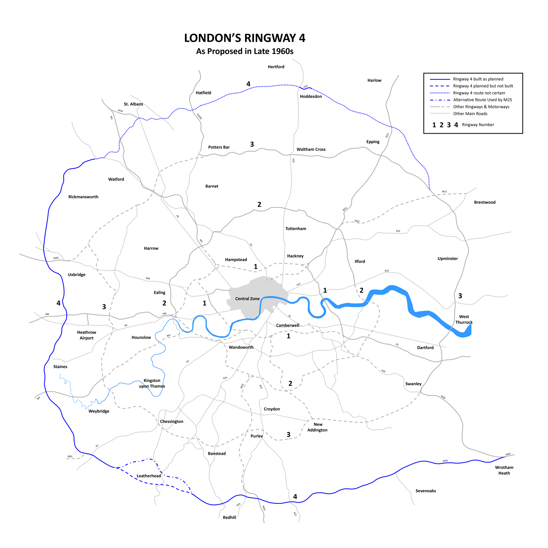
Construction of the first part of the M25 began in 1972 but before it opened, plans for the London Orbital motorway were modified to combine the southern and western part of Ringway 4 with the northern and eastern part of Ringway 3. To connect the two separate routes, which together were numbered as the M25, an additional section of road needed to be planned and the M25 route was diverted northwards from junction 5 to meet Ringway 3 at Swanley (M25 junction 3).
The remaining section of Ringway 4 became the M26. Until February 1986, the anticlockwise M25 simply became the M26 at Junction 5, as the M25 between Junction 5 and Junction 3 was not opened until then.
A few hundred metres of the eastern end is the former A20(M).
Construction
Construction of the M26 began in October 1977, although a route on a similar alignment was originally proposed in the Greater London Plan in 1944 as part of proposed post war improvements to London area transport network. Those proposals were developed further in the 1960s as part of the London Ringways plan and the route of the M26 at that time formed part of Ringway 4 and would have been designated as part of the M25. Construction was slowed down by three wet summers and Gault clay.
It was built by Cementation Ltd, with chief engineer was Ian Watts. It cost £18m. There were 300 people on the project; John Oldham was project manager for the Dunton Green to Wrotham section. There was good weather in 1979. The nearby M20, the West Kingsdown to Addington section, was being built at the same time, by Dowsett. But it would be many years before the nearby M25 was built.
Opening
It was opened on Tuesday 18 November 1980 at 11am at Wrotham by Norman Fowler, Baron Fowler and Mark Wolfson.
Proposed developments
New junction
Kent County Council has been in talks with the Highways Agency over a possible new junction with the A225, allowing direct access to Sevenoaks – or access to the A21 at the M25 junction.
Brexit contingency planning
Plans to modify the M26 to hold large numbers of lorries in the event of a no-deal Brexit were publicly revealed in October 2018.
Junctions
References
- "Motorway Database – M26". CBRD.
- "The Motorway Archive – M26". Motorway Archive Trust.
- ''Kentish Advertiser'' Saturday 22 November 1980, page 10
- ''Kentish Advertiser'' Saturday 15 November 1980, page 1
- ''Times'' Wednesday November 19 1980, page 4
- ''Kentish Advertiser'' Saturday 21 July 1979, page 19
- ''Kentish Advertiser'' Saturday 20 October 1979, page 1
- "Local Transport Plan". Kent County Council.
- (11 October 2018). "UK plan to use motorway as 'parking lot' if no Brexit deal".
- (8 April 2019). "No-deal Brexit: What is the UK government doing to prepare?". BBC News.
This article was imported from Wikipedia and is available under the Creative Commons Attribution-ShareAlike 4.0 License. Content has been adapted to SurfDoc format. Original contributors can be found on the article history page.
Ask Mako anything about M26 motorway — get instant answers, deeper analysis, and related topics.
Research with MakoFree with your Surf account
Create a free account to save articles, ask Mako questions, and organize your research.
Sign up freeThis content may have been generated or modified by AI. CloudSurf Software LLC is not responsible for the accuracy, completeness, or reliability of AI-generated content. Always verify important information from primary sources.
Report