From Surf Wiki (app.surf) — the open knowledge base
Lower Austria
.JPG)
| Field | Value | |
|---|---|---|
| name | Lower Austria | |
| native_name | Niederösterreich | |
| settlement_type | State | |
| image_flag | Flag of Lower Austria.svg | |
| flag_size | 120px | |
| image_shield | Niederösterreich CoA.svg | |
| shield_size | 60px | |
| anthem | Niederösterreiche Landeshymne | |
| image_map | Niederösterreich in Austria.svg | |
| subdivision_type | Country | |
| subdivision_name | ||
| seat_type | Capital | |
| seat | Sankt Pölten | |
| governing_body | Landtag of Lower Austria | |
| leader_party | ÖVP | |
| leader_title | Governor | |
| leader_name | Johanna Mikl-Leitner | |
| leader_title1 | Deputy Governors | |
| leader_name1 | {{Plainlist | |
| area_total_km2 | 18901.2 | |
| population_total | 1698796 | |
| population_as_of | 1 January 2022 | |
| population_density_km2 | auto | |
| demographics_type1 | GDP | |
| demographics1_footnotes | ||
| demographics1_title1 | Total | |
| demographics1_info1 | €65.035 billion (2021) | |
| demographics1_title2 | Per capita | |
| demographics1_info2 | €38,400 (2021) | |
| timezone1 | CET | |
| utc_offset1 | +1 | |
| timezone1_DST | CEST | |
| utc_offset1_DST | +2 | |
| blank_name_sec1 | HDI (2022) | |
| blank_info_sec1 | {{Plainlist | |
| * 0.893<ref name | "GlobalDataLab" | |
| blank1_name_sec2 | Votes in Bundesrat | |
| blank1_info_sec2 | 12 (of 62) | |
| blank_name_sec2 | NUTS Region | |
| blank_info_sec2 | AT1 | |
| iso_code | AT-3 | |
| website |
- Udo Landbauer (FPÖ)
- Stephan Pernkopf (ÖVP)
- 0.893
- · 8th of 9
Lower Austria ( , , abbreviated LA or NÖ) is one of the nine states of Austria, located in the northeastern corner of the country. Major cities are Amstetten, Krems an der Donau, Wiener Neustadt and Sankt Pölten, which has been the capital of Lower Austria since 1986, replacing Vienna, which became a separate state in 1921. With a land area of 19186 km2 and a population of 1.7 million people, Lower Austria is the largest and second-most-populous state in Austria (after Vienna).
Geography
With a land area of 19186 km2 situated east of Upper Austria, Lower Austria is the country's largest state. Lower Austria derives its name from its downriver location on the river Enns, which flows from the west to the east. Lower Austria has an international border, 414 km long, with the Czech Republic (South Bohemia and South Moravia) and Slovakia (Bratislava and Trnava Regions). The state has the second-longest external border of all Austrian states. It also borders the other Austrian states of Upper Austria, Styria and Burgenland as well as surrounding Vienna.
Lower Austria is divided into four regions, known as Viertel (quarters):
- Mostviertel (above the Vienna Woods)
- Industrieviertel (below the Vienna Woods)
- Weinviertel (below the Manhartsberg)
- Waldviertel (above the Manhartsberg)
These regions have different geographical structures. Whilst the Mostviertel is dominated by the foothills of the Limestone Alps with mountains up to (6,500 ft) high, most of the Waldviertel is a granite plateau. The hilly Weinviertel lies to the northeast, descends to the plains of Marchfeld in the east of the state, and is separated by the Danube from the Vienna Basin to the south, which in turn is separated from the Vienna Woods by a line of thermal springs (the Thermenlinie) running north to south.
Mountains

- Schneeberg (Klosterwappen; 2,076 m)
- Rax (Scheibwaldhöhe; 1,943 m; highest summit: Heukuppe; 2,007 m – Styria)
- Ötscher (1,893 m)
- Dürrenstein (1,878 m)
- Schneealpe (Ameisbühel; 1,828 m; highest summit: Windberg; 1,903 m – Styria)
- Hochkar (1,808 m)
- Gamsstein (1,774 m)
- Stumpfmauer (1,770 m)
- Göller (1,766 m)
- Hochwechsel (1,743 m)
- Gippel (1,669 m)
- Großer Sonnleitstein (1,639 m)
- Großer Zellerhut (1,639 m)
- Gemeindealpe (1,626 m)
- Scheiblingstein (1,622 m) (not to be confused with Scheiblingstein (2,197 m), which is in Styria)
- Drahtekogel (1,565 m)
- Sonnwendstein (1,523 m)
- Obersberg (1,467 m)
- Königsberg (1,452 m)
- Großer Sulzberg (1,400 m)
- Reisalpe (1,399 m)
- Gahns (1,380 m)
- Tirolerkogel (1,377 m)
- Türnitzer Höger (1,372 m)
- Unterberg (1,342 m)
- Traisenberg (1,230 m)
- Dürre Wand (1,222 m)
- Hohenstein (1,195 m)
- Eisenstein (1,185 m)
- Hohe Wand (1,132 m)
- Großer Peilstein (1,061 m)
- Weinsberg (1,041 m)
- Hocheck (1,036 m)
- Nebelstein (1,017 m)
- Eibl (1,007 m)
- Hohe Mandling (967 m)
- Jauerling (961 m)
- Hoher Lindkogel also named Eisernes Tor (834 m)
- Anninger (675 m)
- Buschberg (491 m)
Other mountains in Lower Austria may be found at :Category:Mountains of Lower Austria.
Alpine passes
- Semmering (985 m)
- Wechsel (980 m)
The state border with Styria runs over both passes.
Rivers


Almost all of Lower Austria is drained by the Danube. The only river that flows into the North Sea (via the Moldau and the Elbe) is the Lainsitz in northern Waldviertel.
The most important rivers north of the Danube (on its left bank) are the Ysper, Kamp, Krems, Lainsitz, March and Thaya. South of the Danube (on its right bank) are the Enns, Ybbs, Erlauf, Melk, Pielach, Traisen, Schwechat, Fischa, Schwarza, Triesting, Pitten and the Leitha.
Lakes
- Ottenstein Reservoir (4.3 km)
- Lunzer See (0.69 km)
- Erlaufsee (0.56 km, of which about half lies in Lower Austria)
- Erlauf Reservoir
- Wienerwaldsee (0.32 km)
Caves
Lower Austria is rich in natural caves; in all 4,082 have been recorded. Most of the caves have formed in limestone and dolomite rocks and are therefore called karst caves. Cavities also form in the marble of the Central Alps and the Bohemian Massif. Among the largest caves in Lower Austria are:
- Ötscherhöhlensystem (Ötscher): 27,003 m long; union of the Taubenloch and Geldloch
- Pfannloch (Ötscher): 5,287 m long
- Lechnerweidhöhle (Dürrenstein): 5,252 m long
- Trockenes Loch (Schwarzenbach an der Pielach): 4,510 m long
- Hermannshöhle (Kirchberg am Wechsel): 4,430 m long
- Eisensteinhöhle (Bad Fischau): 2,341 m long The last two are open as show caves, along with the Allander stalactite cave, the Unicorn Cave, the Hochkarschacht, the Nixhöhle and the Ötschertropfsteinhöhle.
Land use
| Type of land use | Area in km | Per cent of |
|---|---|---|
| total area | ||
| Farmland | 7,000 | 42 |
| Woods | 6,711 | 40 |
| Grassland | 1,750 | 11 |
| Alpine pastures | 300 | 1.7 |
| Vineyards | 315 | 1.9 |
History
Main article: History of Austria

More than 200 Neolithic people were killed during the massacre in the Linear Pottery settlement area of Schletz 7000 years ago.
The history of Lower Austria is directly connected to the history of Austria. Many castles are located in Lower Austria. Klosterneuburg Abbey, located here, is one of the oldest abbeys in Austria. Before World War II, Lower Austria had the largest number of Jews in the country.
The names Lower Austria and Upper Austria are derived from the earlier names Austria below the Enns and Austria above the Enns, references to the river Enns. Going down from its source on the northern edge of the Central Eastern Alps, the river crosses Upper Austria, then on its lower reaches forms the boundary between Upper Austria and Lower Austria.
In the mid-13th century, it became known as the Principality below the river Enns (Fürstentum unter der Enns).
The Battle on the Marchfeld on 26 August 1278 marked the beginning of the ascendancy of the House of Habsburg in Austria and Central Europe.
During the Ottoman wars in Europe, Lower Austria was the target of repeated raids by the Tatars and Ottoman Akinji mounted paramilitary units, with many people taken into slavery.
Lower Austria was the site of the Battles of Wagram and Aspern, fought between invading French troops under Napoleon and an Austrian army led by Archduke Charles in 1809.
Following the Second World War Lower Austria was occupied by Soviet troops from 1945 until the Austrian State Treaty in effective in 1955.
Economy
The gross domestic product (GDP) of the state was 61.0 billion € in 2018, accounting for 15.8% of Austria's economic output. GDP per capita adjusted for purchasing power was 32,300 €, or 107% of the EU27 average in the same year. Lower Austria is the state with the second-lowest GDP per capita in Austria.
Transport
Air travel to the state is served by Vienna Airport which can easily be accessed by train operated by Railjet and road. Some western parts of Lower Austria such as Waidhofen an der Ybbs and St Valentin can also be served by Linz Airport given its close proximity to the area.
Demographics
|1869|1,077,232 |1880|1,152,767 |1890|1,213,471 |1900|1,310,506 |1910|1,425,238 |1923|1,426,885 |1934|1,446,675 |1939|1,455,373 |1951|1,400,471 |1961|1,374,012 |1971|1,420,816 |1981|1,427,849|1991|1,473,813|2001|1,545,804|2011|1,614,693|2021|1,698,951|source=Censuses|2025|1,727,514}}
Administrative divisions

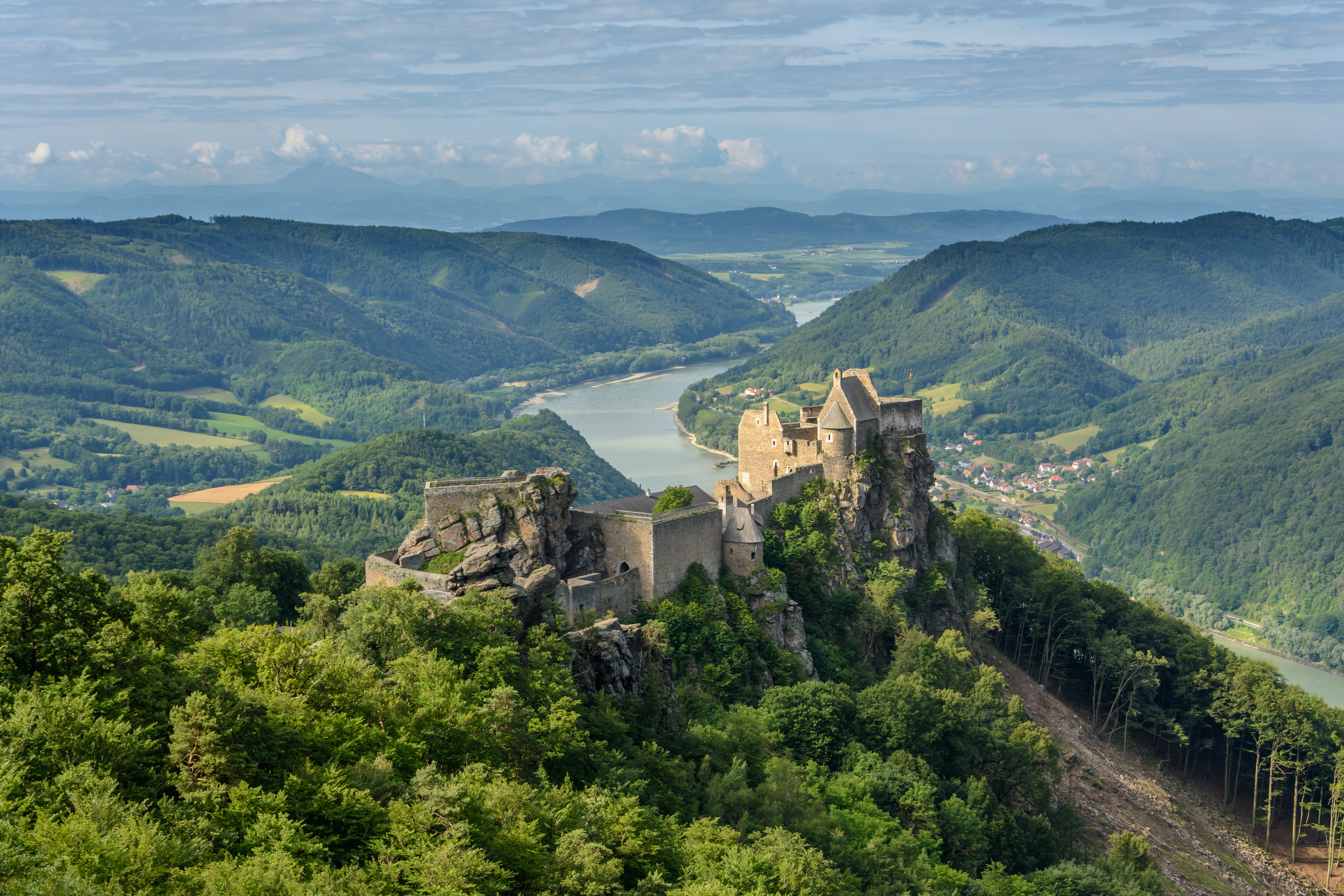
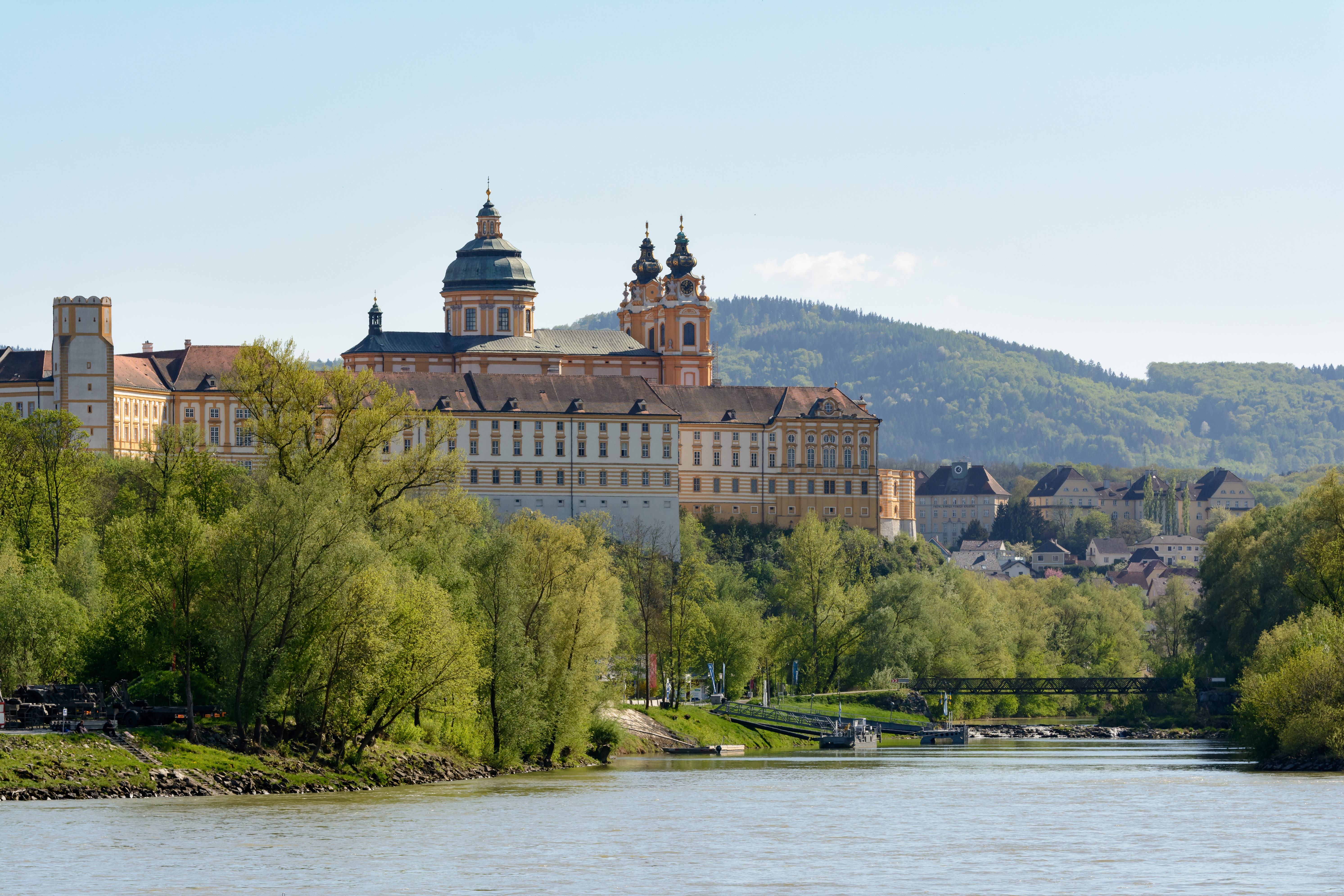
Lower Austria is divided into four regions: Mostviertel, Industrieviertel, Weinviertel and Waldviertel. The Wachau valley, situated between Melk and Krems in the Mostviertel region, is famous for its landscape, culture, and wine.
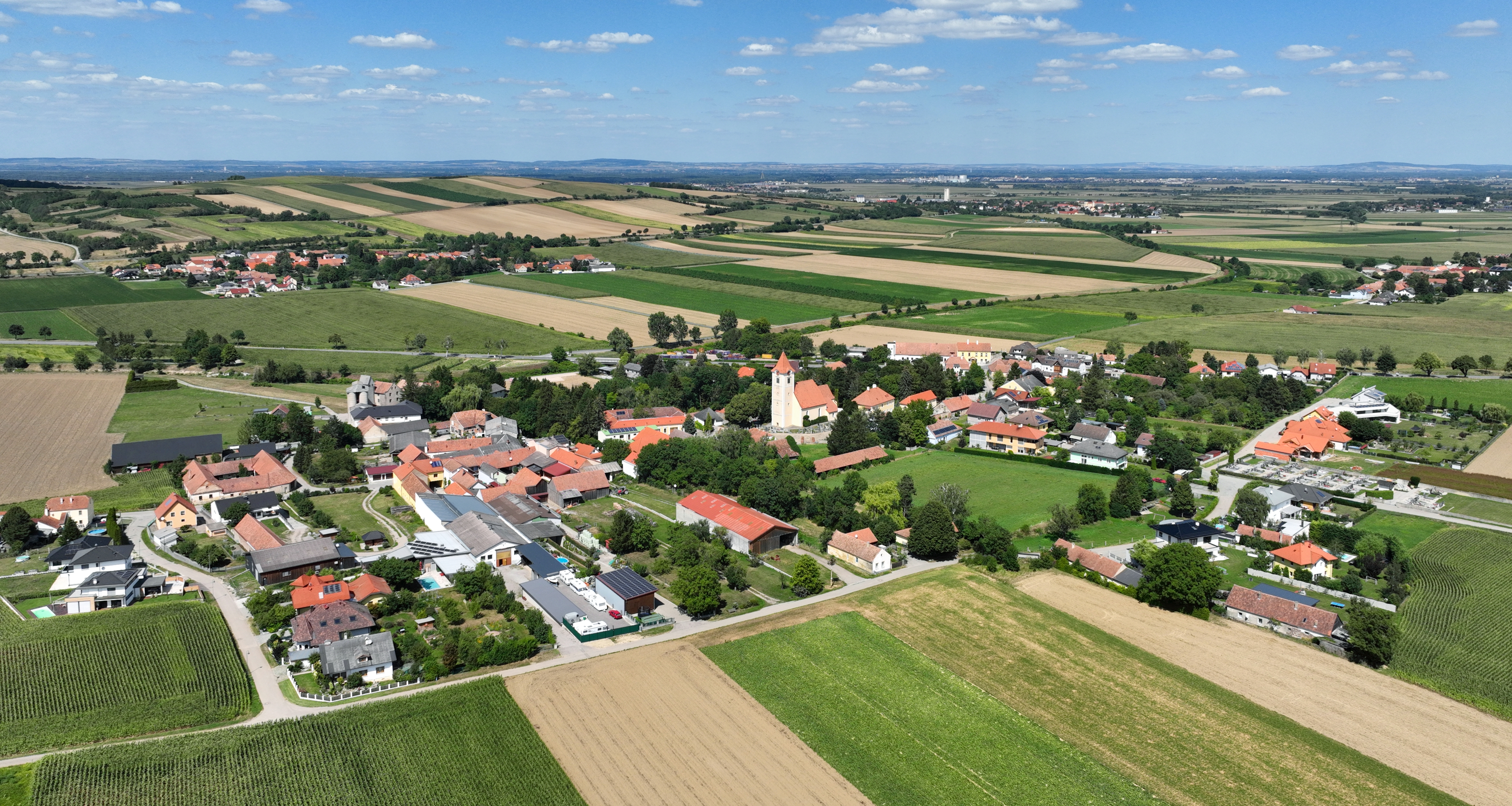
Administratively, the state is divided into 20 districts (Bezirke), and four independent towns (Statutarstädte). In total, there are 573 municipalities within Lower Austria.

Independent towns
- Krems an der Donau
- Sankt Pölten
- Waidhofen
- Wiener Neustadt
Districts
- Amstetten
- Baden
- Bruck an der Leitha
- Gänserndorf
- Gmünd
- Hollabrunn
- Horn
- Korneuburg
- Krems
- Lilienfeld
- Melk
- Mistelbach
- Mödling
- Neunkirchen
- St. Pölten
- Scheibbs
- Tulln an der Donau
- Waidhofen an der Thaya
- Wiener Neustadt
- Zwettl
References
References
- (24 March 2023). "Niederösterreichs Landtag besiegelt Schwarz-Blau – mit einer Minderheit für Mikl-Leitner".
- "Basisdaten Bundesländer".
- "Sub-national HDI - Area Database". Global Data Lab.
- "About the State Parliament of Lower Austria – NÖ Landtag".
- "Visitor-Information".
- Eva Maria Wild et al.: ''Neolithic Massacres: Local Skirmishes or General Warfare in Europe?'' In: ''Radiocarbon.'' Volume 46, No 1, 2004, S. 377–385, [https://www.researchgate.net/publication/236166865_Neolithic_Massacres_Local_Skirmishes_or_General_Warfare_in_Europe text]
- "History of Lower Austria – NÖ Landtag".
- Brian Glyn Williams. (2013). "The Sultan's Raiders: The Military Role of the Crimean Tatars in the Ottoman Empire".
- "Regional GDP per capita ranged from 30% to 263% of the EU average in 2018".
- "Historic Censuses - STATISTICS AUSTRIA". Statistics Austria.
- "Lower Austria in Numbers".
This article was imported from Wikipedia and is available under the Creative Commons Attribution-ShareAlike 4.0 License. Content has been adapted to SurfDoc format. Original contributors can be found on the article history page.
Ask Mako anything about Lower Austria — get instant answers, deeper analysis, and related topics.
Research with MakoFree with your Surf account
Create a free account to save articles, ask Mako questions, and organize your research.
Sign up freeThis content may have been generated or modified by AI. CloudSurf Software LLC is not responsible for the accuracy, completeness, or reliability of AI-generated content. Always verify important information from primary sources.
Report