From Surf Wiki (app.surf) — the open knowledge base
Los Feliz, Los Angeles
.jpg)
| Field | Value |
|---|---|
| name | Los Feliz |
| settlement_type | Neighborhood of Los Angeles |
| image_skyline | {{Photomontage |
| photo1a | Abraham Gore Residence, Harry B. Aarens, Architect 1927 (cropped).jpg |
| photo1b | 4473 Sunset.JPG |
| photo2a | Griffith observatory 2006.jpg |
| photo3a | Thirteenth Church of Christ, Scientist (Los Angeles) west face 2015-05-10 (cropped).jpg |
| photo3b | John Sowden House, Los Angeles (cropped).JPG |
| spacing | 2 |
| position | center |
| color_border | white |
| color | white |
| size | 260 |
| foot_montage | Top: Abraham Gore House (left), Vista Theatre (right); middle: Griffith Observatory; bottom: Church of Christ, Scientist (left), Sowden House (right). |
| pushpin_map | United States Los Angeles Central |
| pushpin_label_position | right |
| pushpin_map_caption | Location within Central Los Angeles |
| elevation_ft | 469 |
| elevation_footnotes | |
| pushpin_mapsize | 250 |
| image_map | Map of Loz Feliz district, Los Angeles, California.png |
| map_caption | Los Feliz neighborhood, as mapped by the Los Angeles Times |
| named_for | Rancho Los Feliz |
| subdivision_type | Country |
| subdivision_name | |
| subdivision_type1 | State |
| subdivision_name1 | California |
| subdivision_type2 | County |
| subdivision_name2 | Los Angeles |
| subdivision_type3 | City |
| subdivision_name3 | Los Angeles |
| timezone | PST |
| utc_offset | -8 |
| timezone_DST | PDT |
| utc_offset_DST | -7 |
| postal_code_type | ZIP code |
| postal_code | 90027 |
| area_codes | 213, 323 |
| coordinates | |
| unit_pref | Imperial |
Los Feliz (; Spanish for "The Féliz (family)", ) is a hillside neighborhood in the greater Hollywood area of Los Angeles, California, abutting Hollywood and encompassing part of the Santa Monica Mountains. The neighborhood is named after the Feliz family of Californios who had owned the area since 1795, when José Vicente Féliz was granted Rancho Los Feliz.
History
Indigenous era
Prior to the arrival of Spanish settlers along the Los Angeles River, the region was inhabited exclusively by Native American groups. It is estimated that these communities lived in the area for thousands of years before European contact.
Spanish and Mexican eras
When Gaspar de Portolà traveled through the vicinity in 1769, his expedition encountered members of this village.
The 6647 acre Rancho Los Feliz, one of the first land grants in California, was granted to Corporal José Vicente Feliz. An old adobe house built in the 1830s by his heirs still stands on Crystal Springs Drive in Griffith Park. Other sections of the rancho were developed and became the communities of Los Feliz and Silver Lake.
Post-Conquest era
_(cropped).jpg)
Following the American conquest of California, Rancho Los Feliz had a succession of owners after the Feliz family. The family first sold the rancho to noted statesman Antonio F. Coronel, before it passed to James Lick, whose estate sold the rancho to Griffith J. Griffith. Griffith donated over half of the ranch to the city of Los Angeles. This ranch became one of the largest city-owned parks in the country, Griffith Park.
In 1882, Colonel Griffith acquired 4071 acre of Rancho Los Feliz. The Lick estate still owned the southwest portion of the rancho and there developed the Lick Tract, which later became a part of Hollywood. Griffith never served in any branch of the U.S. armed forces, but he was given the honorary title of colonel by influential friends in the California National Guard. The title remained a permanent fixture to his name.
Modern era
_(28383742386)_(cropped).jpg)
In 1900, there were only 23 properties in Los Feliz.
Griffith died on July 6, 1919, at the age of 67. Griffith bequeathed $700,000 and his Los Feliz acreage to the city of Los Angeles to be used for additions to Griffith Park.
On August 9, 1969, Charles Manson and six others murdered supermarket executive Leno LaBianca and his wife Rosemary in their home located at 3301 Waverly Drive in Los Feliz, henceforth known as the Tate–LaBianca murders.
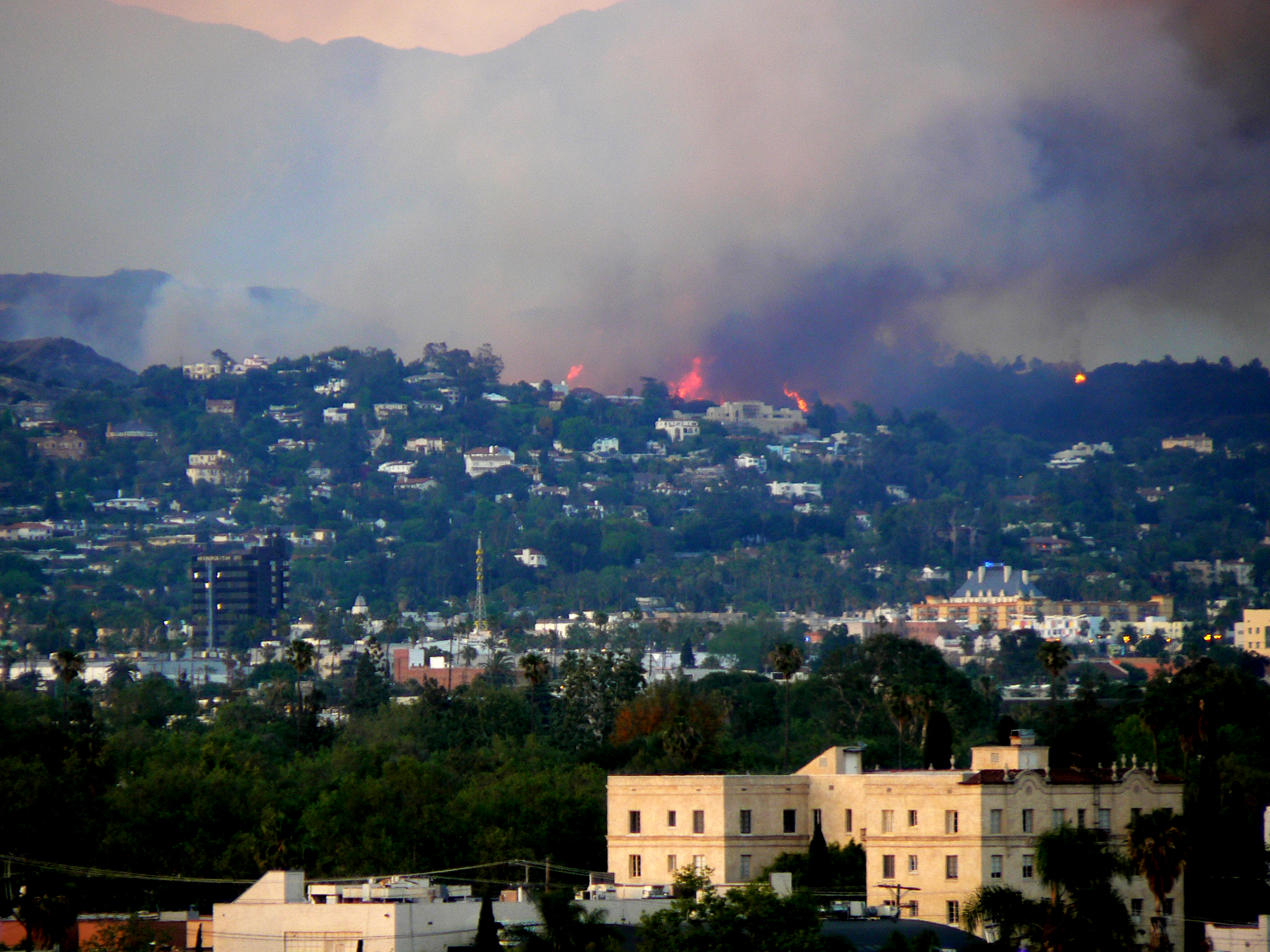
On May 8–9, 2007, about 800 acre of uninhabited terrain in Los Feliz and Griffith Park, including the famous Dante's View, were destroyed in a wildfire. After the fire, Los Angeles city officials pledged millions of dollars in aid to repair the damage.
Geography

Los Feliz encompasses several smaller but distinct areas, including the Los Feliz Hills and Los Feliz Estates (north of Los Feliz Boulevard), Laughlin Park, Los Feliz Village, Los Feliz Square, Los Feliz Knolls, and Franklin Hills.
According to the Mapping L.A. project of the Los Angeles Times, Los Feliz is part of central Los Angeles. It is flanked on the north by Griffith Park, on the northeast by Atwater Village, on the southeast by Silver Lake, on the south by East Hollywood, and on the northwest by Hollywood and Hollywood Hills. Los Feliz is situated near the 101 and the 5 freeways in Hollywood and Atwater Village respectively. The neighborhood's boundaries (as used by Mapping L.A.) are the Griffith Park line between Fern Dell Drive and Riverside Drive on the north; the Los Angeles River on the east; Hyperion Avenue and Griffith Park Boulevard on the southeast; Fountain Avenue and Hollywood Boulevard on the south; and Western Avenue, Los Feliz Boulevard, and Fern Dell Drive on the west and northwest. The boundaries of the Los Feliz Improvement Association extend further west to Canyon Drive.
Los Feliz experiences a hot-summer Mediterranean climate (Csa), just like most of Central Los Angeles.
|Jan record high F = 95 |Feb record high F = 95 |Mar record high F = 99 |Apr record high F = 106 |May record high F = 103 |Jun record high F = 112 |Jul record high F = 109 |Aug record high F = 106 |Sep record high F = 113 |Oct record high F = 108 |Nov record high F = 100 |Dec record high F = 92 |year record high F = |Jan record low F = 28 |Feb record low F = 28 |Mar record low F = 31 |Apr record low F = 36 |May record low F = 40 |Jun record low F = 46 |Jul record low F = 49 |Aug record low F = 49 |Sep record low F = 44 |Oct record low F = 40 |Nov record low F = 34 |Dec record low F = 30 |year record low F =
Demographics

The 2000 U.S. census counted 35,238 residents in the 2.61-square-mile neighborhood—an average of 13,512 people per square mile, among the highest population densities in Los Angeles County. In 2008 the city estimated that the population had increased to 36,933. The median age for residents was 36, older than in the city as a whole; the percentage of residents aged 65 and older was among the county's highest.
The neighborhood was highly diverse ethnically. The breakdown was whites, 57.6%; Latinos, 18.7%; Asians, 13.5%; blacks, 3.7%, and others, 6.6%. Armenia (25.3%) and Mexico (9.4%) were the most common places of birth for the 44.5% of the residents who were born abroad, a high ratio compared to the rest of Los Angeles.
The median yearly household income in 2008 dollars was $50,793, about the same as the rest of Los Angeles, but a high rate of households earned $20,000 or less per year. The average household size of two people was low for the city of Los Angeles. Renters occupied 75.5% of the housing stock, and house or apartment owners the rest.
The percentages of never-married men (50.2%) and never-married women (37.2%) were among the county's highest, as was the percentage of widowed women (10.1%).
Communities

The Los Feliz Neighborhood Council is divided into six interest areas, which include the following communities:
- District A: Los Feliz Hills and Los Feliz Estates
- District B: Los Feliz Square, Laughlin Park, and Thai Town North
- District C: Los Feliz Village
- District D: Los Feliz Knolls and Waverly Heights
- District E: Franklin Hills and a few neighboring blocks
- District F: West Los Feliz The Oaks, a hilly neighborhood on the west side of Los Feliz bordering Griffith Park, is part of the Hollywood United Neighborhood Council. It is, however, within the boundaries of the Los Feliz Improvement Association.
Los Feliz Hills
.jpg)
The area north of Los Feliz Boulevard below Griffith Park is commonly referred to as the Los Feliz Hills. The Los Feliz Hills contain multimillion-dollar homes and have been known for the large share of their inhabitants being involved in creative pursuits. The mean household income is $196,585.
The original subdivision of Los Feliz Heights was subdivided in 1921, from Los Feliz Boulevard north to Griffith Park, from Catalina to Vermont. The Los Feliz Heights Residential Historic District is significant for Period Revival architecture (including American Colonial, Spanish Colonial, Mediterranean, and Tudor Revival styles) from 1920 to 1949. The original subdivision of Hillhurst Park was between Los Feliz Boulevard and Griffith Park, from Vermont Avenue to Commonwealth Avenue. The original subdivision of Los Feliz Hills was to the east, abutting Riverside Drive, Los Feliz Boulevard, and Griffith Park.
Laughlin Park
.jpg)
The gated community of Laughlin Park has 60 houses. In 1998, Laura Meyers of Los Angeles Magazine described the area as "The most seductive, exclusive neighborhood in Los Feliz". W.C. Fields lived here in an Italianate residence built in 1919.
Los Feliz Village
Los Feliz Village is the southern section of Los Feliz, home to most of the commercial storefronts in the district. It is centered on the thoroughfares of Vermont and Hillhurst Avenues and spans from approximately Prospect Avenue to Los Feliz Boulevard. There are several coffee shops, restaurants, and small clothing and vintage stores.
Los Feliz Village Business Improvement District helps promote local businesses and has an annual street fair.
In February 2014, a local shop called Dumb Starbucks was opened as a bit for the Comedy Central show Nathan for You in Los Feliz Village. It has gained notoriety as a parody of Starbucks.
Education
.jpg)
Forty-two percent of Los Feliz residents aged 25 and older had earned a four-year degree in 2000, a high figure for the city.
The schools within Los Feliz are as follows:
- John Marshall Senior High School, LAUSD, 3939 Tracy Street. Designed by architect George M. Lindsey in the Collegiate Gothic style, the school opened on January 26, 1931. After the Sylmar earthquake of 1971, some of Marshall's buildings were condemned. The cafeteria was torn down, but the Main Building was preserved. In 1975, it was closed for structural strengthening, and in September 1981 it was reopened. Mike Haynes Stadium, the school's football and track arena, dates to 1981 and was renovated with a regulation Olympic track and new turf field in 2010.
- Franklin Avenue Elementary School, LAUSD, 1910 North Commonwealth Avenue
- Los Feliz Elementary School, LAUSD, 1740 North New Hampshire Avenue
- Thomas Starr King Middle School, LAUSD, 4201 Fountain Avenue
- Our Mother of Good Counsel, private elementary, 4622 Ambrose Avenue
- Lycée International de Los Angeles Los Feliz campus, private elementary
In 1998, Laura Meyers of the Los Angeles Times said that residents of the Laughlin Park section of Los Feliz "tend not to send their kids to the local public schools" and instead "often" select the Lycée International or the Oaks School.
The Immaculate Heart school is in close proximity to the community.
In popular culture
_south_face_2015-05-10.jpg)
Buena Vista Street, the entrance to the California Adventure theme park at the Disneyland Resort, is partly modeled after Los Feliz in the 1920s and 1930s. The Disney Buena Vista Street includes a retail location called Los Feliz Five and Dime. Disney's Hyperion studio was situated in the Los Feliz area where a Gelson's Market now stands.
In J.G. Quintel's series Close Enough, the main characters live in Los Feliz.
In Swingers, the main characters discuss their personal lives while playing at golf at Los Feliz 9-hole, par 3 golf course.
References
References
- "Worldwide Elevation Finder".
- (December 1996). "Native Tongues".
- Gerber, Marisa. (May 7, 2013). "'Los Feliz': How you say it tells about you and L.A.".
- "Hollywood Community Plan". Los Angeles City Planning.
- [https://planning.lacity.org/odocument/7de89dca-89c9-494e-8e72-e67694613161/SurveyLAHollywood_SurveyReport.pdf Historic Resources Survey Report: Hollywood Community Plan Area]
- Holen, Steven R.. (27 April 2017). "A 130,000-year-old archaeological site in southern California, USA". Nature.
- Bugliosi, Vincent with Gentry, Curt. ''Helter Skelter: The True Story of the Manson Murders 25th Anniversary Edition'', W. W. Norton & Company, 1994. {{ISBN. 0-393-08700-X. {{oclc. 15164618.
- "Los Feliz House Where Leno And Rosemary LaBianca Were Slain By Manson Gang Sold". [[Deadline Hollywood]].
- (May 9, 2007). "Wildfire continues to burn in heart of Los Angeles".
- Ashraf, Khalil. (2007-05-11). "With fire out, officials begin planning Griffith Park repairs". Los Angeles Times.
- [http://projects.latimes.com/mapping-la/neighborhoods/region/central-la/ "Central L.A.", Mapping L.A.], ''Los Angeles Times''
- [http://projects.latimes.com/mapping-la/neighborhoods/region/northeast-la/ "Northeast L.A.", Mapping L.A.], ''Los Angeles Times''
- [http://projects.latimes.com/mapping-la/neighborhoods/neighborhood/los-feliz "Los Feliz", Mapping L.A.], ''Los Angeles Times''
- (2004). "The Thomas Guide: Los Angeles County".
- "Zipcode 90027 - Los Angeles California is in Hardiness Zones 10a and 10b".
- "Boundary Map". Los Feliz Neighborhood Council.
- [https://assets.site-static.com/userFiles/1102/image/Los-Feliz-Neighborhood-Map.png Los Feliz Neighborhood Map] on [https://www.rubyhome.com/los-angeles/los-feliz/ RubyHome]
- "District A - Los Feliz Hills". Los Feliz Neighborhood Council.
- "District B - Los Feliz Square". Los Feliz Neighborhood Council.
- "District C - Los Feliz Village". Los Feliz Neighborhood Council.
- "District D - Los Feliz Knolls". Los Feliz Neighborhood Council.
- "District E". Los Feliz Neighborhood Council.
- "Interest Area District E". Los Feliz Neighborhood Council.
- "West Los Feliz".
- "About Us". The Oaks Neighborhood Association.
- "Hollywood United Neighborhood Council History – Hollywood United Neighborhood Council".
- "Exploring Los Feliz: Interactive Map & Property Search".
- "Los Feliz Improvement Association: Historical Residential Survey".
- (October 15, 2015). "3839 Clayton Avenue: Serene Traditional Living in Franklin Hills".
- "Higley1000.com".
- (April 9, 1922). "The Los Angeles Times from Los Angeles, California on April 9, 1922 · 97".
- (September 6, 1928). "The Los Angeles Times from Los Angeles, California on September 6, 1928 · 38".
- https://www.yumpu.com/en/document/read/10850862/observer-los-feliz-improvement-association "...subdivision known as Los Feliz Heights (an area extending from Los Feliz Blvd. to Griffith Park and from Catalina to Vermont)"
- "Franklin Village Commercial Historic District".
- "Hillhurst Park - David Rumsey Historical Map Collection".
- (6 December 2012). "Los Angeles Department of City Planning: RECOMMENDATION REPORT".
- Communications, Emmis. (January 1998). "Los Angeles Magazine". Emmis Communications.
- Hendrickson, V. L.. (June 7, 2021). "Dodgers Owner Lists Historic Los Angeles Home of for $15 Million". Mansion Global.
- [https://tessa.lapl.org/cdm/ref/collection/maps/id/47 Laughlin Park, 1913] (map), [https://calisphere.org/item/70775ef914b9b4552452cf2d4b80f39c/ Laughlin Park, 1913] (map)
- (February 9, 2014). "'Dumb Starbucks' Shop Appears in L.A.'s Los Feliz".
- [http://projects.latimes.com/mapping-la/neighborhoods/neighborhood/los-feliz/schools/ "Los Feliz Schools", Mapping L.A.], ''Los Angeles Times''
- Communications, Emmis. (Jan 1998). "Los Angeles Magazine". Emmis Communications.
- MacDonald, Brady. (August 20, 2011). "Disney California Adventure shops to reflect Walt's history".
- (8 July 2020). "'Close Enough': TV Review". The Hollywood Reporter.
- Staff, GolfWRX. (June 14, 2018). "Los Feliz Short 9 in Hollywood from the movie "Swingers": 1-Club Challenge".
This article was imported from Wikipedia and is available under the Creative Commons Attribution-ShareAlike 4.0 License. Content has been adapted to SurfDoc format. Original contributors can be found on the article history page.
Ask Mako anything about Los Feliz, Los Angeles — get instant answers, deeper analysis, and related topics.
Research with MakoFree with your Surf account
Create a free account to save articles, ask Mako questions, and organize your research.
Sign up freeThis content may have been generated or modified by AI. CloudSurf Software LLC is not responsible for the accuracy, completeness, or reliability of AI-generated content. Always verify important information from primary sources.
Report