From Surf Wiki (app.surf) — the open knowledge base
Los Amates
| Field | Value | |
|---|---|---|
| official_name | Los Amates | |
| settlement_type | Municipality of Guatemala | |
| image_skyline | Quirigua1897.jpg | |
| image_caption | Quiriguá, Los Amates, in 1897. Picture from Alberto G. Valdeavellano | |
| pushpin_map | Guatemala | |
| pushpin_label_position | bottom | |
| pushpin_map_caption | Location in Guatemala | |
| subdivision_type | Country | |
| subdivision_name | [[Image:Flag of Guatemala.svg | 25px]] Guatemala |
| subdivision_type1 | Department | |
| subdivision_name1 | Izabal Department | |
| leader_title1 | Mayor (2016-2020) | |
| leader_name1 | Milton Panteleón | |
| leader_party | TODOS | |
| established_title | Settled | |
| established_date | 30 June 1916 | |
| established_title3 | ||
| unit_pref | Imperial | |
| area_total_km2 | 1049 | |
| area_land_km2 | ||
| population_as_of | 2018 census | |
| population_footnotes | ||
| population_total | 60914 | |
| population_density_km2 | auto | |
| population_blank1_title | Ethnicities | |
| population_blank2_title | Religions | |
| timezone | GMT_6 | |
| coordinates | ||
| elevation_footnotes | tags-- | |
| elevation_m | 77 | |
| postal_code_type | ||
| blank_name | Climate | |
| blank_info | Am |
Los Amates is a municipality in the Izabal department of Guatemala. At the 2018 census, the population was 60,914. The mayor is currently Marco Tulio Ramirez Estrada. Los Amates is located on the Motagua River, 6 km from the ruins of the ancient Maya city of Quiriguá.
History
Quiriguá
Main article: Quiriguá
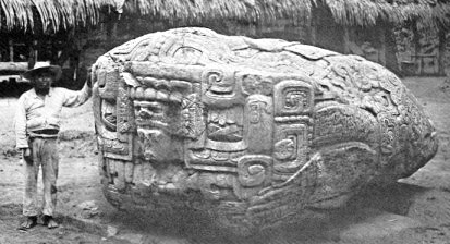
Quiriguá is an ancient Maya archaeological site in Los Amates. It is a medium-sized site covering approximately 3 km2 along the lower Motagua River, with the ceremonial center about 1 km from the north bank. During the Maya Classic Period (AD 200–900), Quiriguá was situated at the juncture of several important trade routes. The site was occupied by 200, construction on the acropolis had begun by about 550, and an explosion of grander construction started in the 8th century. All construction had halted by about 850, except for a brief period of reoccupation in the Early Postclassic (c. 900 – c. 1200). Quiriguá shares its architectural and sculptural styles with the nearby Classic Period city of Copán, with whose history it is closely entwined.
After the Independence of Central America
The area was largely abandoned during the Spanish Colony of Guatemala, and the first European visitor to publish an account of Los Amates was English architect and artist Frederick Catherwood, who reached the Quiriguá ruins in 1840, during the turbulent times of president general Rafael Carrera. Due to adverse conditions he was only able to stay a short time at the ruins, but made drawings of two of the stelae, which were published with a short account of Catherwood's visit in John Lloyd Stephens's book Incidents of Travel in Central America, Chiapas, and Yucatan in 1841. A longer account of the ruins was made in 1854 by Dr. Karl Scherzer.
Explorer and archaeologist Alfred Maudslay visited Quiriguá for three days in 1881; they were the first pre-Columbian ruins that he saw and they were sufficiently impressive to inspire him to take up a permanent interest in Central American archaeology.
Los Amates train station
Main article: Northern Railroad of Guatemala
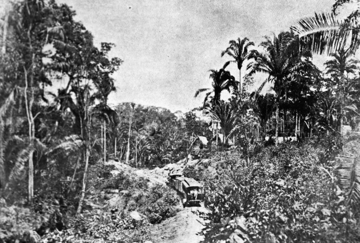
On 22 November 1896 the Northern Railroad Zacapa, Zacapa-Puerto Barrios connection, was opened to the public; it was the most important infrastructure project of general José María Reina Barrios given the economic crisis the loomed over Guatemala if he was not able to finish the railroad on time for the Central American Expo schedule for March 1897. The new line would have one hundred and one miles. In those days, the Northern region of Guatemala was practically a new and unexplored area, a newfound place where natural resources could be exploited and the railroad construction finally gave way to the commercial and industrial exploration of the area. The complete line Puerto Barrios-Guatemala City -through Panajax- had one hundred and ninety seven miles and was built in stages (which later became train stops): from Puerto Barrios to Tenedores, eighteen miles; from Tenedores to Los Amates, forty one miles; from Los Amates to Gualán, twenty one miles; from Zacapa to El Rancho de San Agustín, thirty four miles; from El Rancho to Panajax, thirty miles; and finally, from Panajax to Guatemala city, thirty two miles.
In 1910, the United Fruit Company bought Quiriguá, Los Amates and all the land for a great distance around for banana production; they set aside 75 acre around the ceremonial centre as an archaeological park, leaving an island of jungle among the plantations. More archaeological work was carried out from 1910 to 1914 by Edgar Lee Hewett and Sylvanus Morley for the School of American Archaeology in Santa Fe. The Carnegie Institution conducted several intermittent projects at Quiriguá from 1915 through 1934.
Municipality establishment
Los Amates municipality was established by an executive action of president Manuel Estrada Cabrera on 30 June 1916, and ratified and organized on 24 June 1920. On 28 January 1944 the municipality capital was moved to Quirigua, but the change was brief as it was derogated on 12 April of that year.
United Fruit Company
Main article: United Fruit Company
In early 1920, after the Unionist party deposed Manuel Estrada Cabrera, the United Fruit Company -which had received considerable concessions from the Guatemalan president in the past two decades in Izabal- was suddenly confronted with a large strike and did not have the help from the government to repress it due to the fighting taking place in Guatemala City. New labor chapters opened both in Morales and Los Amates banana plantations, while Puerto Barrios had more than 250 members. The strike grew stronger and upon the resistance of the Unionists to help it, UFCO supported a coup d'état led by general José María Orellana in 1921, who swiftly repressed the union members and gave tranquility to the United Fruit Company operations in Izabal.
Franja Transversal del Norte
Main article: Franja Transversal del Norte
In the 1960s, the importance of the region known as Franja Transversal del Norte was in livestock, exploitation of precious export wood and archaeological wealth. Timber contracts we granted to multinational companies such as Murphy Pacific Corporation from California, which invested US$30 million for the colonization of southern Petén and Alta Verapaz, and formed the North Impulsadora Company. Colonization of the area was made through a process by which inhospitable areas of the Franja Transversal del Norte (FTN) were granted to native peasants.
In 1964, the National Institute for Agrarian Transformation (INTA) defined the geography of the FTN as the northern part of the departments of Huehuetenango, Quiché, Alta Verapaz and Izabal and that same year priests of the Maryknoll order and the Order of the Sacred Heart began the first process of colonization, along with INTA, carrying settlers from Huehuetenango to the Ixcán sector in Quiché.
The Northern Transversal Strip was officially created during the government of General Carlos Arana Osorio in 1970, by Decree 60-70 in the Congress, for agricultural development. The area included within the municipalities: San Ana Huista, San Antonio Huista, Nentón, Jacaltenango, San Mateo Ixtatán, and Santa Cruz Barillas in Huehuetenango; Chajul and San Miguel Uspantán in Quiché; Cobán, Chisec, San Pedro Carchá, Lanquín, Senahú, Cahabón and Chahal, in Alta Verapaz and the entire department of Izabal.
Climate
Los Amates has a tropical monsoon climate (Köppen: Am) and its municipal capital is 78 m above sea level.
|access-date= 5 September 2015
References
- Canal Antigua. (2015). "TSE presenta resultados oficiales de alcaldes en Izabal". Canal Antigua.
- [https://www.citypopulation.de/en/guatemala/admin/ Citypopulation.de] Population of departments and municipalities in Guatemala
- Ashmore, Wendy. (1980). "The Classic Maya Settlement at Quirigua: Recent agricultural activities have helped reveal the extent of the buried settlement". [[University of Pennsylvania Museum of Archaeology and Anthropology]].
- Sharer, Robert J.. (2006). "The Ancient Maya". [[Stanford University Press]].
- Miller, Mary Ellen. (1999). "Maya Art and Architecture". [[Thames & Hudson]].
- Kelly. 1996
- (1854). "Incidents of travel in Central America, Chiapas, and Yucatan". Arthur Hall, Virtue and Co..
- Trustees of the British Museum. (n.d.). "Alfred P. Maudslay (1850–1931)". [[British Museum.
- {{harvnb. Kelly. 1996
- San Diego Museum of Man. (n.d.). "Casts of our Maya Monuments". [[San Diego Museum of Man]].
- San Diego Museum of Man. (n.d.). "Maya: Heart of Sky, Heart of Earth". [[San Diego Museum of Man]].
- Prins Wilhelm. (1922). "Between two continents, notes from a journey in Central America, 1920". E. Nash and Grayson, Ltd..
- Colby, Jason M.. (2011). "The business of empire: United Fruit, race and U.S. expansion in Central America". Cornell University Press.
- "Franja Transversal del Norte". Wikiguate.
- SEGEPLAN. "Municipios de Izabal, Guatemala".
This article was imported from Wikipedia and is available under the Creative Commons Attribution-ShareAlike 4.0 License. Content has been adapted to SurfDoc format. Original contributors can be found on the article history page.
Ask Mako anything about Los Amates — get instant answers, deeper analysis, and related topics.
Research with MakoFree with your Surf account
Create a free account to save articles, ask Mako questions, and organize your research.
Sign up freeThis content may have been generated or modified by AI. CloudSurf Software LLC is not responsible for the accuracy, completeness, or reliability of AI-generated content. Always verify important information from primary sources.
Report