From Surf Wiki (app.surf) — the open knowledge base
Loei province
Province of Thailand
Province of Thailand
| Field | Value |
|---|---|
| name | Loei |
| native_name | เลย |
| native_name_lang | th |
| settlement_type | Province |
| image_seal | File:Seal Loei.png |
| image_flag | Flag of Loei.svg |
| nickname | ตำรวจภาคส่วน สำนักงานตำรวจแห่งชาติ |
| motto | City of the sea of mountains, coldest place in Siam, with beautiful flowers of three seasons |
| image_map | Thailand Loei locator map.svg |
| mapsize | frameless |
| map_caption | Map of Thailand highlighting Loei province |
| coordinates | |
| subdivision_type | Country |
| subdivision_name | Thailand |
| seat_type | Capital |
| seat | Loei |
| leader_title | Governor |
| leader_name | Chaipote Jaroonpong |
| leader_title1 | PAO Chief Executive |
| leader_name1 | Chaithawat Niamsiri |
| area_footnotes | |
| area_total_km2 | 10,500 |
| area_rank | 16th |
| population_footnotes | |
| population_total | 632,187 |
| population_as_of | 2024 |
| population_rank | 42nd |
| population_density_km2 | 60 |
| population_density_rank | 68th |
| demographics_type2 | GDP |
| demographics2_footnotes | |
| demographics2_title1 | Total |
| demographics2_info1 | baht 53 billion |
| (US$1.8 billion) (2019) | |
| demographics_type1 | Human Achievement Index |
| demographics1_footnotes | |
| demographics1_title1 | HAI (2022) |
| demographics1_info1 | 0.6407 "average" |
| Ranked 39th | |
| timezone1 | ICT |
| utc_offset1 | +7 |
| postal_code_type | Postal code |
| postal_code | 42xxx |
| area_code_type | Calling code |
| area_code | 042 |
| iso_code | TH-42 |
| registration_plate | เลย |
| website |
(US$1.8 billion) (2019) Ranked 39th
Loei (Thai: เลย, ), is one of the more sparsely populated provinces (changwat) of Thailand. It lies in the Isan region of upper northeastern Thailand. Neighboring provinces are (from east clockwise) Nong Khai, Udon Thani, Nong Bua Lamphu, Khon Kaen, Phetchabun, and Phitsanulok. In the north it borders Xaignabouli and Vientiane province of Laos.
, the provincial governor is Chaiwat Chuenkosum. The province was allocated 225.6 million baht in the FY2019 Thailand budget.
History
Loei was founded by a Thai tribe from the Kingdom of Yonok Chiang Saen. Khun Pha Muang founded the village of Dan-kwa, and Bang Klang Hao founded Dan Sai. Drought and disease later led to the villagers move to the site of present-day Loei.
In 1907, King Chulalongkorn (Rama V) created Loei province. The Loei Cultural Centre (ศูนย์วัฒนธรรมจังหวัดเลย) displays Loei's history, religions, and traditions. The province is home to many Lao people who fled the Communist take-over of the Kingdom of Laos. The area of the province along the Lao border is used by the Laotians to buy and sell goods with the locals on the Thai side.
Geography
The province is mountainous. The seat of provincial government, Loei, is in a fertile basin surrounded by mountains whose summits are covered by fog and abundant varied flora. The best known mountains in the province are Phu Kradueng, Phu Luang, and Phu Ruea. The Loei River, which flows through the province, is a tributary of the Mekong, which forms part of the northern boundary of the province with neighboring Laos. Phu Thap Buek, the highest mountain of the Phetchabun Range, is in the province. The mountain Phu Kradueng is in Phu Kradueng National Park (อุทยานแห่งชาติภูกระดึง). The western part of the province reaches the southern end of the Luang Prabang Range of the Thai highlands. The total forested area is 3,382 km² or 32.2 percent of the province.
National parks
There are four national parks, along with two other national parks, make up region 8 (Khon Kaen), and Na Yung–Nam Som in region 10 (Udon Thani) and Phu Hin Rong Kla region 11 (Phitsanulok) of Thailand's protected areas.
- Na Yung–Nam Som National Park, 397 km2
- Phu Pha Man National Park, 350 km2
- Phu Kradueng National Park, 348 km2
- Phu Hin Rong Kla National Park, 307 km2
- Phu Ruea National Park, 121 km2
- Phu Suan Sai National Park, 117 km2
Wildlife sanctuaries
There are three wildlife sanctuaries, two of which are in region 8 (Khon Kaen), and Phu Khat in region 11 (Phitsanulok) of Thailand's protected areas.
- Phu Luang Wildlife Sanctuary, 897 km2
- Phu Khat Wildlife Sanctuary, 241 km2
- Phu Kho–Phu Kratae Wildlife Sanctuary, 232 km2
Demographics
Loei province is home to several Tai peoples. The indigenous people are the Tai Lue, while the Phuan, Tai Dam, Thai, and Chinese people make up the rest of the population. The Tai Phuan people came to the province after migrating from Luang Prabang in Laos.
Symbols
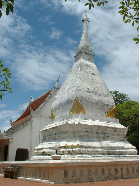
The seal of the province shows the stupa at Phra That Si Song Rak, which was built in 1560 by King Maha Chakrapat of the Ayutthaya Kingdom and King Saysettha of Lan Xang as a symbol of friendship between the two kingdoms. The provincial tree is the Khasi pine (Pinus kesiya). Altigena lippa the cyprinid fish is the provincial aquatic life.
The provincial slogan is "city of the sea of mountains, coldest place in Siam, with beautiful flowers of three seasons."
Economy
Agriculture drives Loei's economy. Macadamia nuts, passion fruit, and Arabica coffee are grown in the highlands; bananas, sesame, and rubber on the plains. Loei is an ecotourism destination due to its natural environment and amalgam of northern and northeastern cultures.
Wang Saphung District is the site of a large open pit gold mine that employs many locals. The locality has been the site of a long-standing dispute as well as physical conflict between the villagers of Ban Na Nong Bong and its environs and Tungkum Limited, a subsidiary of Tongkah Harbour PCL. Tungkum's gold mining operation has been accused in the courts of environmental destruction.
Administrative divisions

Provincial government
The province is divided into 14 districts (amphoe). The districts are further divided into 89 subdistricts (tambons) and 839 villages (mubans).
Local government
As of 26 November 2019 there are: one Loei Provincial Administration Organisation (ongkan borihan suan changwat) and 29 municipal (thesaban) areas in the province. Loei with Wang Saphung have town (thesaban mueang) status. There are a further 27 subdistrict municipalities (thesaban tambon). The non-municipal areas are administered by 71 Subdistrict Administrative Organisations, SAO (ongkan borihan suan tambon).
Transport
Route 201 leads from Chiang Khan in the north on the border with Laos, through Loei, to Non Sa-at near Chum Phae. Route 203 leads west to the vicinity of Phu Ruea, and then turns south to Lom Sak.
Loei is served by Loei Airport.
Human achievement index 2022
| Loei province, with a 2022 HAI value of 0.6407, is "average", occupies place 39 in the ranking. |
|---|
Since 2003, United Nations Development Programme (UNDP) in Thailand has tracked progress on human development at the provincial level using the Human achievement index (HAI), a composite index measuring eight key areas of human development. The National Economic and Social Development Board (NESDB) has taken over this task since 2017.
| 62 – 77 | "low" |
|---|
| [[File:HAI 2022 rankings.svg | 950px]] |
|---|
Gallery
File:Sun rise at Nok Aen Cliff-2 ,Phu Kradueng National Park.jpg|Sunrise, Pha Nok Aen File:อุทยานแห่งชาติภูกระดึง001.jpg|Phu Kradueng National Park File:อุทยานแห่งชาติภูกระดึง2.jpg|Phu Kradueng National Park File:Phukradung.JPG|Phu Kradueng File:อุทยานแห่งชาติภูกระดึง 7.jpg|Phu Kradueng File:พืชเล็กๆ อุทยานแห่งชาติภูกระดึง.jpg|Phu Kradueng File:เส้นทางอันสวยงานแห่งภูเรือ.jpg|Phu Ruea National Park File:Man Daeng Waterfall.jpg|Man Daeng Waterfall, Phu Hin Rong Kla National Park File:Nahaew district.JPG|Na Haeo District File:ChiangKhan.jpg|Chiang Khan
References
References
- "Table 2 Forest area Separate province year 2019". Royal Forest Department.
- "Official statistics registration systems". Department of Provincial Administration (DOPA).
- (July 2019). "''Gross Regional and Provincial Product, 2019 Edition''". Office of the National Economic and Social Development Council (NESDC).
- "ข้อมูลสถิติดัชนีความก้าวหน้าของคน ปี 2565 (PDF)".
- (2 May 2020). "Loei governor rises as 'savior' in Covid-19 struggle". Thai PBS World.
- (20 December 2018). "Thailand's Budget in Brief Fiscal Year 2019". Bureau of the Budget.
- "เกี่ยวกับจังหวัด {{!}} สำนักงานธนารักษ์พื้นที่เลย".
- "Loei Cultural Center".
- Patchsuti, Warapol. "“จังหวัดเลย” เริ่มแล้วสงกรานต์ไทย-ลาว อ.นาแห้ว".
- "Ban Thap Boek".
- "Phu Kradueng National Park".
- ดร.กระมล ทองธรรมชาติ และคณะ, สังคมศึกษา ศาสนาและวัฒนธรรม ม.1, สำนักพิมพ์ อักษรเจริญทัศน์ อจท. จำกัด, 2548, หน้า 24-25
- (2019). "ตาราง 5 พื้นที่เขตรักษาพันธุ์สัตว์ป่า พ.ศ. 2562".
- "Loei".
- "About Loei".
- "Loei: General Info".
- (2016-06-05). "Struggle against mining violations leaves activists exposed". Bangkok Post.
- (26 November 2019). "Number of local government organizations by province". Department of Local Administration (DLA).
- "Loei Airport". OurAirports.
This article was imported from Wikipedia and is available under the Creative Commons Attribution-ShareAlike 4.0 License. Content has been adapted to SurfDoc format. Original contributors can be found on the article history page.
Ask Mako anything about Loei province — get instant answers, deeper analysis, and related topics.
Research with MakoFree with your Surf account
Create a free account to save articles, ask Mako questions, and organize your research.
Sign up freeThis content may have been generated or modified by AI. CloudSurf Software LLC is not responsible for the accuracy, completeness, or reliability of AI-generated content. Always verify important information from primary sources.
Report