From Surf Wiki (app.surf) — the open knowledge base
Littlebredy
Village in Dorset, England
Village in Dorset, England
| Field | Value |
|---|---|
| country | England |
| official_name | Littlebredy |
| static_image_name | Church of St Michael and All Angels, Little Bredy - geograph.org.uk - 31320.jpg |
| static_image_caption | Parish church of St Michael and All Angels |
| coordinates | |
| map_type | Dorset |
| population | 121 |
| population_ref | |
| unitary_england | Dorset |
| lieutenancy_england | Dorset |
| region | South West England |
| post_town | Dorchester |
| postcode_area | DT |
| postcode_district | DT2 |
| constituency_westminster | West Dorset |
| os_grid_reference | SY588890 |
| website | Village website |
Littlebredy (also written Little Bredy, pronounced ) is a small village and civil parish in the English county of Dorset, situated approximately 6.5 mi west of the county town Dorchester. It is sited at the head of the valley of the small River Bride, surrounded by wooded chalk hills of the Dorset Downs. The parish contains the Valley of Stones National Nature Reserve and is in an area rich with evidence of early human occupation. In the 2011 census it had a population of 121.
History
The area around Littlebredy is rich with evidence of early human occupation, including stone circles, strip lynchets, tumuli (long and round barrows) and a probable hill fort. North and east of the village the density of barrows is as great as the area around Stonehenge. One mile north of the village and just outside the parish is a group of 44 Bronze Age round barrows of various sizes, known as Winterbourne Poor Lot Barrows or just Poor Lot. On a hill immediately south of the village are the earthworks of Old Warren (or Danes' Camp), which most likely was a univallate (single rampart) Iron Age hill fort. Old Warren may later have been used as a burh in the time of Alfred the Great, though it may have been not completed, or abandoned in favour of a site at what is now Bridport.
Records from the 10th century refer to the area as 'Bridian' or 'Brydian' The words 'Bride' and 'Bredy' derive from the Celtic for a torrential, gushing stream; the addition of 'Little' distinguishes the parish from the larger neighbouring parish of Long Bredy.
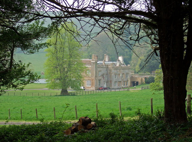
Littlebredy was owned by Cerne Abbey until the Dissolution of the Monasteries in the 16th century, when the Abbey sold its land to Philip Vanwilder. The estate subsequently passed to the Freke family of Iwerne Courtney and then Sir Robert Meller (or Mellor) of Winterborne Came, who built Bridehead House in the early 17th century. In 1730 the estate was bought by the Meech family who in 1797 sold it to wealthy banker Robert Williams from Hertfordshire.
During the 19th century the Williams family—headed by four successive Roberts who all became members of parliament—made substantial changes to the estate. The architects Peter Frederick Robinson and then Benjamin Ferrey were employed. Bridehead House was extended and altered by Robinson in 1830–33, then extended further by Ferrey a few years later. The River Bride was dammed near its source to create a lake as part of landscaping around the house. Ferrey also designed new cottages to form an estate village and provided plans for restoring the parish church, including adding a spire to its 14th-century tower. Some Jacobean buildings in the village were also changed around this time, being reworked into a Gothic farmyard or stable block. Ferrey's plan for the church—which involved virtually rebuilding it—was implemented in 1847 under the supervision of the third Robert Williams' brother-in-law, Arthur Acland, who also had an architectural input.
In the churchyard is a memorial to Frederic Wallis, Bishop of Wellington, New Zealand, who married into the Williams family. It is made from the wood of a tree sent specially from New Zealand.

In 2024 the Williams family put the estate, which includes the 32 houses in the village, up for sale. In 2025 it was sold to unknown buyers. The new owners terminated the previous public access to the lake and waterfall on Bridehead Estate. In June 2025 it was reported by the journalist and activist George Monbiot that the new owners had served notice of eviction on the tenants of all the houses in the village. However, the new owners, Belport Limited, stated that they intend to reopen access to the closed area after certain issues are addressed following works, and denied that they plan to evict tenants from properties on the estate.
Government
For elections to the British House of Commons, Littlebredy is in the West Dorset parliamentary constituency.
At the upper tier of local government, Littlebredy is the Dorset unitary authority area. For elections to Dorset Council, it is in the Chesil Bank electoral ward.
At the lower tier, Littlebredy is a civil parish. It does not have a parish council, but it does have parish meetings.
Geography
Littlebredy village is sited between 85 and 110 metres above sea-level All of Littlebredy parish lies within the Dorset National Landscape area.
Valley of Stones
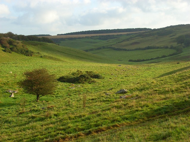
In the south of the parish is the Valley of Stones, which in 1906 was described by Sir Frederick Treves as "a mysterious glen among the downs, on whose grassy slopes many huge stones are scattered." In prehistoric times it was used as a source of building material for nearby constructions such as tombs and stone circles, and within 4 miles are two-thirds of all such structures in the county. Folklore attributes the origin of the stones to have been two giants playing stone-throwing games, but they are the result of conditions at the end of the last ice age, when freezing and thawing caused sandstone on surrounding hilltops to break up and slump downhill. They form one of the best British examples of a sarsen stone boulder train. The stones and the surrounding dry chalk valley provide habitats for a variety of flora and fauna—including clustered bellflower, autumn gentian, lichens, bryophytes and the adonis blue butterfly—and the area is designated a National Nature Reserve.
Demography
In the 2011 census Littlebredy civil parish had 53 dwellings, 45 households and a population of 121.
The population of the parish in the censuses between 1921 and 2001 is shown in the table below:
| Census Population of Littlebredy Parish 1921–2001 (except 1941) | Census | 1921 | 1931 | 1951 | 1961 | 1971 | 1981 | 1991 | 2001 | Population |
|---|---|---|---|---|---|---|---|---|---|---|
| 136 | 158 | 132 | 101 | 80 | 80 | 100 | 90 | |||
| Source:Dorset County Council |
In the 1861 census the parish had 41 inhabited dwellings and a population of 199.
Notable people
- Robert Meller (c.1564-1624), member of parliament
- Ben Pentreath (born 1971), architect and interior designer
Notes
References
- "Area: Littlebredy (Parish), Key Figures for 2011 Census: Key Statistics". [[Office for National Statistics]].
- Ken Ayres. (January 2010). "Bridehead revisited". Dorset Life Magazine.
- Roland Gant. (1980). "Dorset Villages". Robert Hale Ltd.
- "Little Bredy". Dorset OPC Project.
- (c. 1983). "West Dorset, Holiday and Tourist Guide". [[West Dorset District Council]].
- [[Ordnance Survey]] 1:25,000 Pathfinder Series of Great Britain, Sheet SY 49/59 Bridport, published 1977
- (1999–2013). "Extracts from C.J. Bailey's Book "The Bride Valley"". Burton Bradstock ONLINE Committee.
- "Winterbourne Poor Lot Barrows". English Heritage.
- (2007). "Old Warren". [[English Heritage]].
- (2014). "'Bredy, Little', An Inventory of the Historical Monuments in Dorset, Volume 1: West (1952), pp. 37–39". University of London & History of Parliament Trust.
- (11 November 2011). "Little Bredy". Dorset Ancestors.
- "Little Bredy, St. Michael & All Angels". The Dorset Historic Churches Trust.
- (29 June 2024). "The £30 million Dorset estate that comes with a 200-year-old mansion, a cricket ground, a nature reserve and an entire village". [[Country Life (magazine).
- Morris, Steven. (31 May 2025). "Anger as Dorset estate withdraws public entry to 'stunning' local landmark". The Guardian.
- Monbiot, George. (28 June 2025). "An entire village in Dorset is facing eviction – proof that private money holds all the power in rural England". The Guardian.
- Lumb, Alfie. (1 July 2025). "Belport to reopen public access to Bridehead, Littlebredy". Bridport News.
- "Littlebredy Parish Meeting". [[Dorset County Council]].
- at the head of the small River Bride, surrounded by wooded chalk hills of the Dorset Downs. It is {{convert. 6.5. mi. km west of the county town Dorchester, {{convert. 8. mi. km east of [[Bridport]], {{convert. 8. mi. km northwest of [[Weymouth, Dorset. Weymouth]] and {{convert. 3.5. mi. km north of the [[English Channel]]. The nearest railway stations are [[Maiden Newton railway station. Maiden Newton]], [[Dorchester West railway station. Dorchester West]], [[Dorchester South railway station. Dorchester South]], [[Upwey railway station, Dorset. Upwey]] and [[Weymouth railway station. Weymouth]], which are all within a direct radius of {{convert. 8.5. mi. km. The nearest main road is the [[A35 road. A35 trunk road]] approximately {{convert. 1. mi. km to the north.John Bartholomew & Son Ltd 1:100,000 National Map Series, Sheet 4 Dorset, published 1980
- "Dorset AONB Map". Dorset AONB Partnership.
- "Valley of Stones NNR". Natural England.
- Maureen Hymas. (1981). "Dorset Folklore". Books of Wessex Ltd.
- "Area: Littlebredy (Parish), Dwellings, Household Spaces and Accommodation Type, 2011 (KS401EW)". [[Office for National Statistics]].
- (17 March 2010). "Parishes (A-L), 1921–2001– Census Years". [[Dorset County Council]].
- "Parish of Little Bredy, 1861 Census". Dorset OPC Project.
This article was imported from Wikipedia and is available under the Creative Commons Attribution-ShareAlike 4.0 License. Content has been adapted to SurfDoc format. Original contributors can be found on the article history page.
Ask Mako anything about Littlebredy — get instant answers, deeper analysis, and related topics.
Research with MakoFree with your Surf account
Create a free account to save articles, ask Mako questions, and organize your research.
Sign up freeThis content may have been generated or modified by AI. CloudSurf Software LLC is not responsible for the accuracy, completeness, or reliability of AI-generated content. Always verify important information from primary sources.
Report