From Surf Wiki (app.surf) — the open knowledge base
Linwood, New Zealand
Suburb of Christchurch, New Zealand
Suburb of Christchurch, New Zealand
| Field | Value |
|---|---|
| name | Linwood |
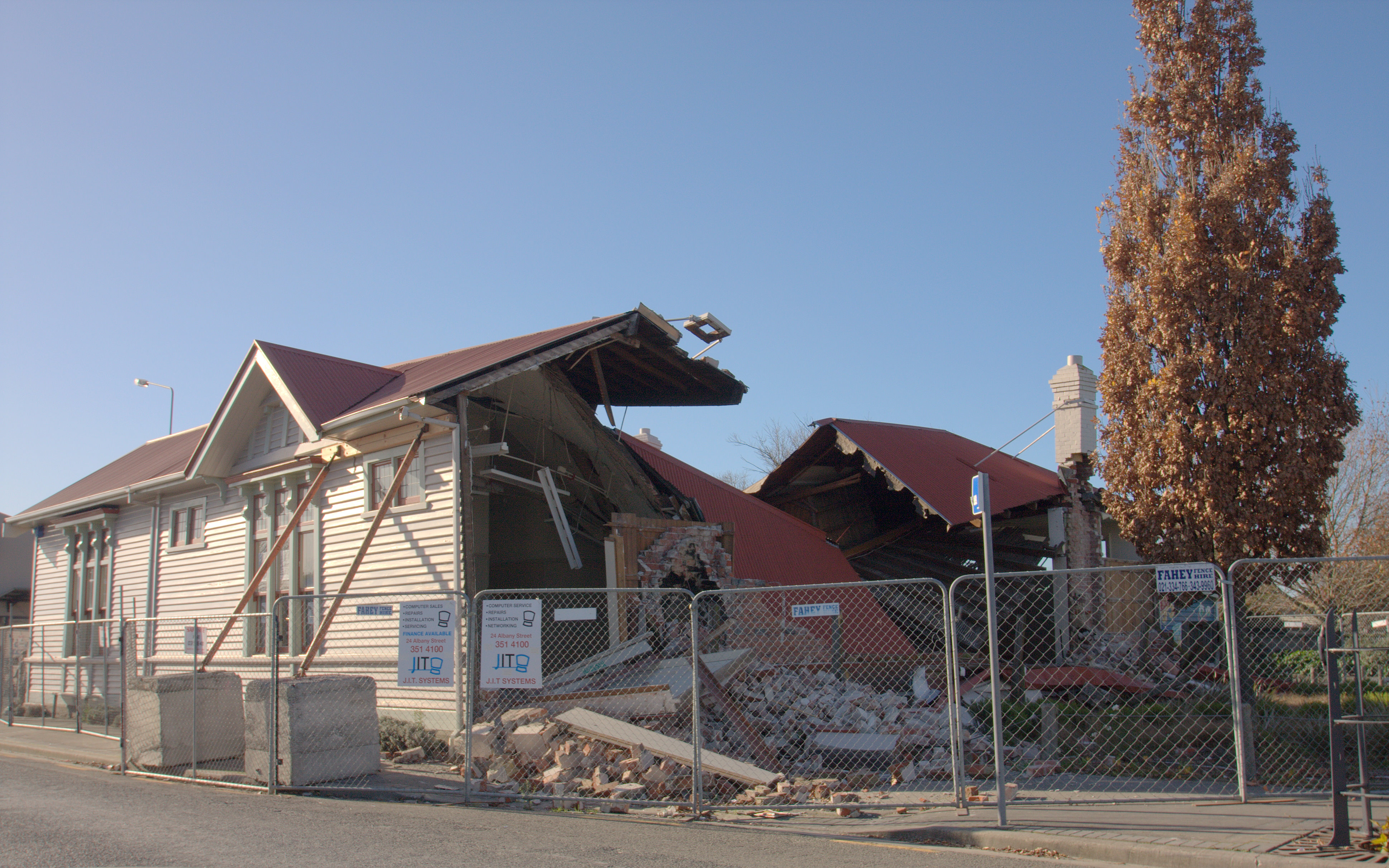
| image | Linwood House, 2003.jpg |
| caption1 | Linwood House in 2003 |
| city1 | Christchurch |
| council | Christchurch City Council |
| ward | |
| community_board | |
| established | 1850s |
| coordinates | |
| area | 285 |
| areasource | |
| population | |
| popdate | |
| popref | |
| population_density_km2 | auto |
| mapframe | yes |
| mapframe-zoom | 11 |
| mapframe-zoom = 11
Linwood is an inner suburb of the city of Christchurch, New Zealand. It lies to the east of the city centre, mostly between Ferry Road and Linwood Avenue, two of the major arterial roads to the eastern suburbs of Christchurch. It is one of the city's older suburbs, established in 1850.
History
Linwood is one of Christchurch's older suburbs which was established in 1850. "Linwood" was given its name by Joseph Brittan, who purchased rural section 300 in Avonside. The adjoining rural section 301 was to be part of the farm, but the right was sold but probably farmed with rural section 300 and was eventually bought back by his son in 1874. To this was added a small part of section 30 to give access in 1855 and 21-year lease for the adjoining sections in 1862 giving a total area of about 380 acres (about 150ha). He called the farm Linwood, as he was from Linwood, Hampshire. Brittan built Linwood House at 30 Linwood Avenue in 1857, which stood there until demolition following the February 2011 Christchurch earthquake.
Christchurch lacked an accessible port before the construction of the Lyttelton Rail Tunnel in 1867. This posed a significant problem for the fledgling city. A barge service along what is now Linwood Avenue was mooted prior to this tunnel but was never completed.
The Linwood Islamic Centre was the site of a mass shooting during the Christchurch mosque shootings on 15 March 2019.
Demographics
Linwood covers 2.85 km2. It had an estimated population of as of with a population density of people per km2.
Linwood had a population of 9,783 at the 2018 New Zealand census, an increase of 1,161 people (13.5%) since the 2013 census, and an increase of 768 people (8.5%) since the 2006 census. There were 3,873 households, comprising 5,043 males and 4,743 females, giving a sex ratio of 1.06 males per female, with 1,563 people (16.0%) aged under 15 years, 2,559 (26.2%) aged 15 to 29, 4,593 (46.9%) aged 30 to 64, and 1,074 (11.0%) aged 65 or older.
Ethnicities were 64.5% European/Pākehā, 16.9% Māori, 6.9% Pasifika, 21.3% Asian, and 3.9% other ethnicities. People may identify with more than one ethnicity.
The percentage of people born overseas was 31.8, compared with 27.1% nationally.
Although some people chose not to answer the census's question about religious affiliation, 45.9% had no religion, 32.0% were Christian, 1.1% had Māori religious beliefs, 5.9% were Hindu, 1.7% were Muslim, 1.2% were Buddhist and 4.9% had other religions.
Of those at least 15 years old, 1,503 (18.3%) people had a bachelor's or higher degree, and 1,635 (19.9%) people had no formal qualifications. 636 people (7.7%) earned over $70,000 compared to 17.2% nationally. The employment status of those at least 15 was that 4,215 (51.3%) people were employed full-time, 1,101 (13.4%) were part-time, and 459 (5.6%) were unemployed.
| Name | Area | |||||||
|---|---|---|---|---|---|---|---|---|
| (km2) | Population | Density | ||||||
| (per km2) | Households | Median age | Median | |||||
| income | New Zealand | 37.4 years | $31,800 | |||||
| Linwood West | 1.08 | 4,962 | 4,594 | 2,115 | 32.9 years | $28,300 | ||
| Linwood North | 0.86 | 2,709 | 3,150 | 990 | 36.0 years | $27,700 | ||
| Linwood East | 0.91 | 2,112 | 2,321 | 768 | 34.7 years | $28,100 |
Economy
Retail

A long established retail section is on Stanmore Road around the intersections with Gloucester and Worcester Streets. It underwent significant upgrading in the 2020s and has been described as an urban village.
Linwood's main commercial area is located around the intersection of Linwood Avenue, Aldwins Road and Buckleys Road. There is also a shopping mall in the suburb, known as Eastgate Mall (formerly Linwood City) that contains a Christchurch City Council community centre and a library. It covers an area of 30,500 m2. It is a two level shopping mall but used to encompass a much larger area prior to the 22 February 2011 earthquake. The mall has 1100 carparks and 37 shops, including The Warehouse, Woolworths, Warehouse Stationery, Number One Shoes and Lincraft.
Parks
The largest parks in Linwood are Bromley Park and the adjacent Linwood Cemetery, followed by Beverley Park and the North Linwood Community Park. As there are no defined suburb boundaries in Christchurch, post code boundaries are sometimes used for suburb boundaries (e.g. by Google Maps). According to Google Maps, most of Woodham Park is located in Linwood whilst only part of Linwood Park belongs to the eponymous suburb. Most commonly, Aldwins Road and Linwood Avenue are considered the boundary roads of Woolston and if so, Linwood Park is located in Woolston.
Education
Te Aratai College is a secondary school for years 7 to 13. It has a roll of . The school opened in 1954.
Te Pā o Rākaihautū is a Kura Kaupapa Māori composite school which teaches years 1 to 13 in the Māori language. It has a roll of . It was founded in 2015.
Linwood Avenue Primary School and Whītau School are contributing primary schools for years 1 to 6, with rolls of and students, respectively. Linwood Avenue opened in 1928, and Whītau opened in 1908 as Linwood North School.
All of these are coeducational state schools. Rolls are as of
Notable people
- Lianne Dalziel (born 1960), former Mayor of Christchurch from 2013–2022.
References
References
- (2012). "Linwood Village Master Plan".
- Archives NZ land records
- {{NZHPT. 3119. Linwood House. 13 August 2011
- Greenaway, Richard L. N.. (June 2007). "Avonside Anglican Parish Cemetery Tour". Christchurch City Libraries.
- Cronshaw, Tim. (5 March 2011). "Heritage heartbreak looms". [[The Press]].
- (24 August 2020). "Christchurch mosque terror attack sentencing: Gunman Brenton Tarrant planned to attack three mosques". New Zealand Herald.
- "ArcGIS Web Application".
- {{NZ census 2018. Linwood West (327900), Linwood North (328500) and Linwood East (329300)
- {{NZ census place summary 2018. linwood-west. Linwood West
- {{NZ census place summary 2018. linwood-north. Linwood North
- {{NZ census place summary 2018. linwood-east. Linwood East
- (8 February 2024). "'More people-friendly and pleasant' Linwood Village on the way". Star Media Network.
- "Linwood Village Master Plan". CCC.
- (23 December 2001). "Growth plans for Eastgate Mall". Wilson & Horton.
- "Our shops - Eastgate Mall". Eastgate Mall.
- McDonald, Liz. (2024-11-08). "Eastgate Mall sold, buyers have ‘big plans’". The Press.
- "Bromley Park".
- "Linwood Cemetery".
- "Beverley Park & Playground".
- "Woodham Park".
- "Linwood Park".
- {{TKI. 337. Linwood College
- "Welcome to Linwood College - Warm greetings to the Linwood community". Linwood College.
- {{TKI. 706. Te Pā o Rākaihautū
- "Te Pā o Rākaihautū".
- {{TKI. 3413. Linwood Avenue Primary School
- {{TKI. 3415. Whītau School
- "Miscellaneous Local Historical Information". Christchurch City Libraries.
- Baker, Timothy David. (1908). "Linwood North School centennial, 1908-2008". Linwood North School.
- (6 November 2019). "Whītau School". Education Review Office.
This article was imported from Wikipedia and is available under the Creative Commons Attribution-ShareAlike 4.0 License. Content has been adapted to SurfDoc format. Original contributors can be found on the article history page.
Ask Mako anything about Linwood, New Zealand — get instant answers, deeper analysis, and related topics.
Research with MakoFree with your Surf account
Create a free account to save articles, ask Mako questions, and organize your research.
Sign up freeThis content may have been generated or modified by AI. CloudSurf Software LLC is not responsible for the accuracy, completeness, or reliability of AI-generated content. Always verify important information from primary sources.
Report