From Surf Wiki (app.surf) — the open knowledge base
Lichfield District
.JPG)
| Field | Value | |||
|---|---|---|---|---|
| name | Lichfield District | |||
| native_name | ||||
| settlement_type | Non-metropolitan district | |||
| total_type | ||||
| image_skyline | {{multiple image | |||
| border | infobox | perrow = 1/2 | total_width = 280 | align=center |
| image1 | Lichfield-Cathedral-June2020.jpg | |||
| image2 | Birmingham ^ Fazeley Canal near Fazeley Junction - geograph.org.uk - 4707618.jpg | |||
| image3 | Main Street in Alrewas, Staffordshire (geograph 7290139).jpg | |||
| image4 | Allotments near Armitage, Staffordshire - geograph.org.uk - 6952984.jpg | |||
| image5 | Clifton Campville, St. Andrew's Church - geograph.org.uk - 4943401.jpg | |||
| image6 | Eastridge Croft with Shenstone Church Tower showing behind the Houses - geograph.org.uk - 2810676.jpg | |||
| image7 | Chasetown Station - running round the train - geograph.org.uk - 4369849.jpg}} | |||
| image_caption | ||||
| blank_emblem_size | 110px | |||
| image_map | Lichfield UK locator map.svg | |||
| mapsize | frameless | |||
| map_caption | Shown within Staffordshire | |||
| dot_x | dot_y = | |||
| pushpin_map | ||||
| pushpin_label_position | ||||
| subdivision_type | Sovereign state | |||
| subdivision_name | United Kingdom | |||
| subdivision_type1 | Constituent country | |||
| subdivision_name1 | England | |||
| subdivision_type2 | Region | |||
| subdivision_name2 | West Midlands | |||
| subdivision_type3 | Ceremonial county | |||
| subdivision_name3 | Staffordshire | |||
| subdivision_type4 | Admin HQ | |||
| subdivision_name4 | Lichfield | |||
| parts_style | ||||
| parts | ||||
| p2 | ||||
| government_type | Non-metropolitan district | |||
| leader_title2 | MPs: | |||
| leader_name2 | Dave Robertson L | |||
| established_title | Created | |||
| established_date | 1 April 1974 | |||
| unit_pref | ||||
| area_total_km2 | 331.3 | |||
| area_land_km2 | ||||
| elevation_footnotes | tags-- | |||
| population_as_of | ||||
| population_total | (Ranked ) | |||
| demographics_type1 | Ethnicity (2021) | |||
| demographics1_footnotes | ||||
| demographics1_title1 | Ethnic groups | |||
| demographics_type2 | Religion (2021) | |||
| demographics2_footnotes | ||||
| demographics2_title1 | Religion | |||
| population_density_km2 | ||||
| timezone | GMT | |||
| utc_offset | 0 | |||
| timezone_DST | BST | |||
| utc_offset_DST | +1 | |||
| coor_pinpoint | ||||
| postal_code_type | Post Code | |||
| postal_code | WS7, 9, 13-15, DE13, B74-78 | |||
| area_code | 01543 |
Default is list if up to 5 items, coll if more than 5--
Sarah Edwards L | 94.8% White | 2.3% Asian | 1.9% Mixed | 0.6% Black | 0.4% other | 57.1% Christianity | 40.1% no religion | 0.7% Islam | 0.5% Hinduism | 0% Judaism | 0.9% Sikhism | 0.2% Buddhism | 0.4% other Lichfield District () is a local government district in Staffordshire, England. The district is named after its largest settlement, the city of Lichfield, which is where the district council is based. The district also contains the towns of Burntwood and Fazeley, along with numerous villages and surrounding rural areas, including part of Cannock Chase, a designated Area of Outstanding Natural Beauty.
The neighbouring districts are Cannock Chase, Stafford, East Staffordshire, South Derbyshire, North West Leicestershire, North Warwickshire, Tamworth, Birmingham and Walsall.
History
The district was formed on 1 April 1974 under the Local Government Act 1972. The new district covered two former districts, which were both abolished at the same time:
- Lichfield Municipal Borough
- Lichfield Rural District (except the parish of Brindley Heath, which went to Cannock Chase)
The borough of Lichfield had held city status from time immemorial. When the new district was created the area of the former borough became an unparished area with charter trustees to preserve its city status and other civic dignities. In 1980 the area of the former borough was made a civil parish, the charter trustees were wound up and the city status was re-conferred onto the new parish of Lichfield. As such, "Lichfield City Council" is a parish council, whilst "Lichfield District Council" is a district council with wider powers and covering the much larger area of Lichfield District.
Between 2011 and 2023, Lichfield formed part of the Greater Birmingham & Solihull Local Enterprise Partnership.
Governance
| coa-pic = | coa-res = Conservative Conservative ;Administration (20) : ;Other parties (27) : Labour (16) : : Reform UK (1) : Lichfield District Council provides district-level services. County-level services are provided by Staffordshire County Council. The whole district is also covered by civil parishes, which form a third tier of local government.
Political control
The council has been under no overall control since the 2023 election, being run by a Conservative minority administration.
The first election to the district council was held in 1973, initially operating as a shadow authority alongside the outgoing authorities until the new arrangements took effect on 1 April 1974. Political control of the council since 1974 has been as follows:
| Party in control | Years | |
|---|---|---|
Leadership
The leaders of the council since 1977 have been:
| Councillor | Party | From | To | |||||||
|---|---|---|---|---|---|---|---|---|---|---|
| David Lightbown | 1977 | 1983 | ||||||||
| Arnold Ward | 1983 | May 1995 | ||||||||
| Peter Van Hagen | May 1995 | Dec 1998 | ||||||||
| Tony Lanchester | Dec 1998 | May 1999 | ||||||||
| last1=Elkes | first1=Neil | title=Tories in triumph after tense finish | url=https://www.findmypast.co.uk/image-viewer?issue=BL%2F0000379%2F19990513&page=4 | access-date=16 July 2025 | work=Lichfield Mercury | date=13 May 1999 | page=4}} | May 1999 | 11 May 2010 | |
| title=Council minutes, 11 May 2010 | url=https://democracy.lichfielddc.gov.uk/Data/Council/20100713/Agenda/AGENDA%20ITEM%203%201%20.pdf | website=Lichfield District Council | access-date=16 July 2025}} | 11 May 2010 | 21 May 2019 | |||||
| title=Council minutes, 21 May 2019 | url=https://democracy.lichfielddc.gov.uk/documents/s7059/Item%204%20-%20Minutes%20-%20Annual%20Council%20-%2021%20May%202019.pdf | website=Lichfield District Council | access-date=16 July 2025}} | 21 May 2019 |
Composition
Following the 2023 election, and subsequent by-elections and changes of allegiance up to May 2025, the composition of the council was:
| Party | Councillors | Total | 47 |
|---|---|---|---|
| 20 | |||
| 16 | |||
| 7 | |||
| 1 | |||
| 3 |
The next election is due in 2027.
Premises
The district council is based at the District Council House on Frog Lane. The building began as Lichfield Grammar School, which had been founded in 1495 and moved to this site in 1577. The oldest surviving part of the complex is the former headmaster's house at 45 St John Street, built in 1682. The main school room behind the house was rebuilt in 1849. The school moved to new premises in 1903 and later became the King Edward VI School in 1971. The former school buildings at the corner of St John Street and Frog Lane were bought by Lichfield Rural District Council in 1917 and subsequently converted to be that council's offices in 1920. Following the local government reorganisation in 1974 the building passed to the current Lichfield District Council. A large extension was added in 1987 facing Frog Lane, incorporating a new main entrance. The 1849 school room serves as the council chamber.
Elections
Since the last boundary changes in 2015 the council has comprised 47 councillors representing 22 wards, with each ward electing one, two or three councillors. Elections are held every four years.
Wards
Lichfield District's 22 wards are:
- Alrewas and Fradley
- Armitage with Handsacre
- Boley Park
- Boney Hay and Central
- Bourne Vale
- Chadsmead
- Chase Terrace
- Chasetown
- Colton and the Ridwares
- Curborough
- Fazeley
- Hammerwich with Wall
- Highfield
- Leomansley
- Little Aston and Stonnall
- Longdon
- Mease Valley
- Shenstone
- St John’s
- Stowe
- Summerfield and All Saints
- Whittington and Streethay
Wider political boundaries
The district includes areas in two parliamentary constituencies: Lichfield and Tamworth.
Geography
Settlements within the district
- Alrewas, Armitage
- Blithbury, Burntwood
- Chase Terrace, Chasetown, Chesterfield, Chorley, Clifton Campville, Colton, Comberford, Croxall, Curborough
- Drayton Bassett
- Edingale, Elford, Elmhurst
- Farewell, Fazeley, Fisherwick, Fradley
- Gentleshaw
- Hademore, Hammerwich, Hamstall Ridware, Handsacre, Harlaston, Haunton, Hill Ridware, Hilliards Cross, Hints, Hopwas
- Kings Bromley
- Lichfield, Little Aston, Little Hay, Longdon
- Mavesyn Ridware, Mile Oak
- Orgreave
- Pipe Ridware
- Rileyhill
- Shenstone, Stockwell Heath, Stonnall, Streethay, Swinfen
- Thorpe Constantine
- Upper Longdon
- Wall, Weeford, Whittington, Wigginton
Parishes
The entire district is divided into civil parishes. The parish council for Lichfield itself takes the style "city council", and the parish councils for Burntwood and Fazeley take the style "town council".
Demography
According to mid-2020 estimates, the population of Lichfield district is 105,637, with 53,583 (50.7%) of the population female.
In the 2011 census, 69% of the population reported their religion as Christianity, and 23% reported no religion. 6% did not state a religion, with the remainder reporting other religions. The most common ethnicity was White British, 94.6%, followed by Other White, 1.5%, and Asian/Asian British: Indian, 0.9%.
Places of interest


Adventure and excitement
- [[Image:Themepark uk icon.png|16px]]Drayton Manor Theme Park – A 280-acre theme park and zoo with 35 rides in total, including 5 roller coasters and 4 water rides.
- Curborough Sprint Course – A premier motorsport venue for speed sprinting against the clock.
Arts and entertainment
- [[Image:Drama-icon.svg|16px]]Lichfield Garrick Theatre – A modern theatre seating 480 people, named after David Garrick who was brought up in Lichfield.
History and heritage
- [[Image:AP Icon.svg|16px]]Lichfield Cathedral – The only medieval cathedral in Europe with three spires. The present building was started in 1195, and completed by the building of the Lady Chapel in the 1330s. It replaced a Norman building begun in 1085 which had replaced one, or possibly two, Saxon buildings from the seventh century.
- Cathedral Close – Surrounding the Cathedral with its many fine buildings is one of the most unspoilt in the country.
- [[Image:Museum icon.png]]Samuel Johnson Birthplace Museum – A museum to Samuel Johnson's life, work and personality.
- [[Image:Museum icon.png]]Erasmus Darwin House – Home to Erasmus Darwin, the house was restored to create a museum which opened to the public in 1999.
- [[Image:Museum icon.png]]Lichfield Heritage Centre – in St Mary's Church in the market square, an exhibition of 2,000 years of Lichfield's history.
- [[Image:HH icon.png|Historical House]]Bishop's Palace – Built in 1687, the palace was the residence of the Bishop of Lichfield until 1954, it is now used by the Cathedral School.
- Milley's Hospital – Located on Beacon Street, it dates back to 1504 and was a women's hospital.
- [[Image:HH icon.png|Historical House]]Hospital of St John Baptist without the Barrs – A distinctive Tudor building with a row of eight brick chimneys. This was built outside the city walls (barrs) to provide accommodation for travellers arriving after the city gates were closed. It now provides a home for elderly people and has an adjacent Chapel.
- [[Image:AP Icon.svg|16px]]Church of St Chad – A 12th-century church though extensively restored, on its site is a Holy Well by which St Chad is said to have prayed and used the waters healing properties.
- [[Image:AP Icon.svg|16px]]St Michael on Greenhill – Overlooking the city the ancient churchyard is unique as one of the largest in the country at 9 acre.
- [[Image:AP Icon.svg|16px]]Christ Church – An outstanding example of Victorian ecclesiastical architecture and a grade II* listed building.
- The Franciscan Friary – The ruins of the former Friary in Lichfield, now classed as a Scheduled Ancient Monument.
- Lichfield Clock Tower – A Grade II listed 19th century clock tower, located south of Festival Gardens.
- [[Image:EH icon.svg]] [[Image:NTE icon.png]]Letocetum – The remains of a Roman Staging Post and Bath House, in the village of Wall, 1 mi south of the city.
- [[Image:Museum icon.png]]Staffordshire Regiment Museum – 2.5 mi east of the city in Whittington, the museum covers the regiment's history, activities and members, and include photographs, uniforms, weapons, medals, artifacts, memorabilia and regimental regalia. Outdoors is a replica trench from World War I, and several armoured fighting vehicles.
- The Market Square – In the centre of the city of Lichfield, the square contains two statues, one of Samuel Johnson overlooking the house in which he was born, and one of his great friends and biographer, James Boswell.
Parks and the great outdoors
- Beacon Park – An 81 acre public park in the centre of the city, used for many sporting and recreational activities.
- Minster Pool & Stowe Pool – The two lakes occupying 16 acres in the heart of Lichfield, Stowe Pool is designated a SSSI site as it is home to native White-Clawed Crayfish.
- National Memorial Arboretum – 4 mi northeast of the city in Alrewas, the arboretum is a national site of remembrance and contains many memorials to the armed services.
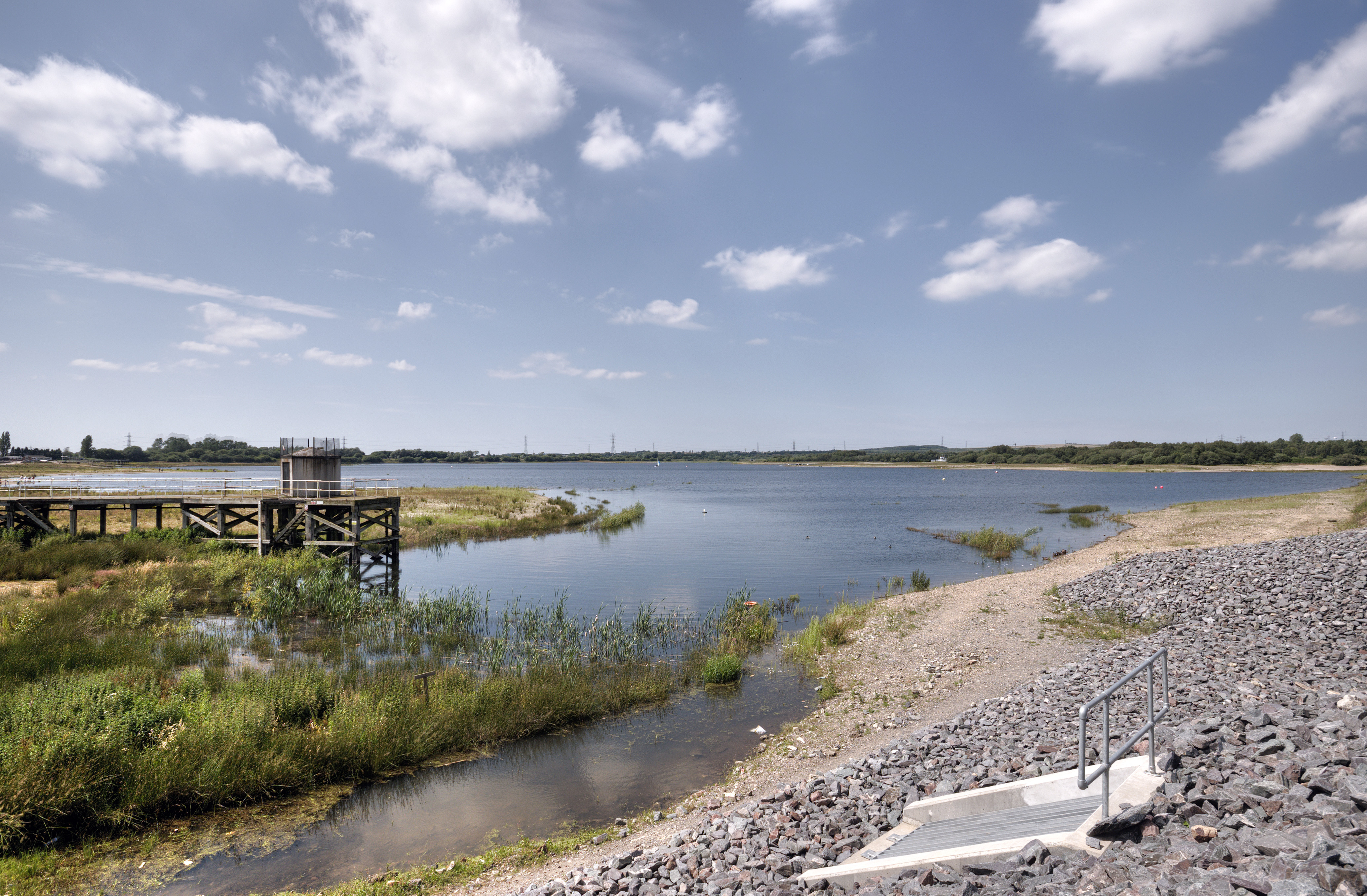
- Chasewater Country Park – A country park including a 3-square-kilometre reservoir which hosts a variety of activities including water skiing, sailing, angling and bird watching. The Chasewater habitat also supports several rare plant and animal species.
- Chasewater Railway – A 2 mile long, former colliery railway running round the shores of Chasewater.
- Garden of Remembrance – Located next to Lichfield Cathedral and Minster Pool, the garden was opened in 1920 to commemorate soldiers lost in the First World War.
- Gentleshaw Common – A Site of Special Scientific Interest that contains rare species of heathland plants.
- Fradley Junction – A canal junction between Fradley and Alrewas popular with gongoozlers and other visitors. Fradley Pool Nature Reserve is adjacent to the junction.
- Prince's Park – Located in Burntwood, it is featured in the Guinness Book of Records for being the smallest park in the United Kingdom.
Shopping and retail
- Three Spires Shopping Centre – The principal shopping area in the heart of Lichfield with over 40 stores and 750 parking spaces.
- Heart of the Country Shopping Village – A shopping village with shops, galleries and restaurants, 2 mile south of Lichfield.
Plans have been approved for Friarsgate, a new £100 million shopping and leisure complex opposite Lichfield City Station. The police station, bus station, Ford garage and multi-storey car park will be demolished to make way for new retail space and leisure facilities consisting of a flagship department store, six-screen cinema, hotel, 37 individual shops, 56 apartments and over 700 car parking spaces.
Staffordshire Hoard Discovery
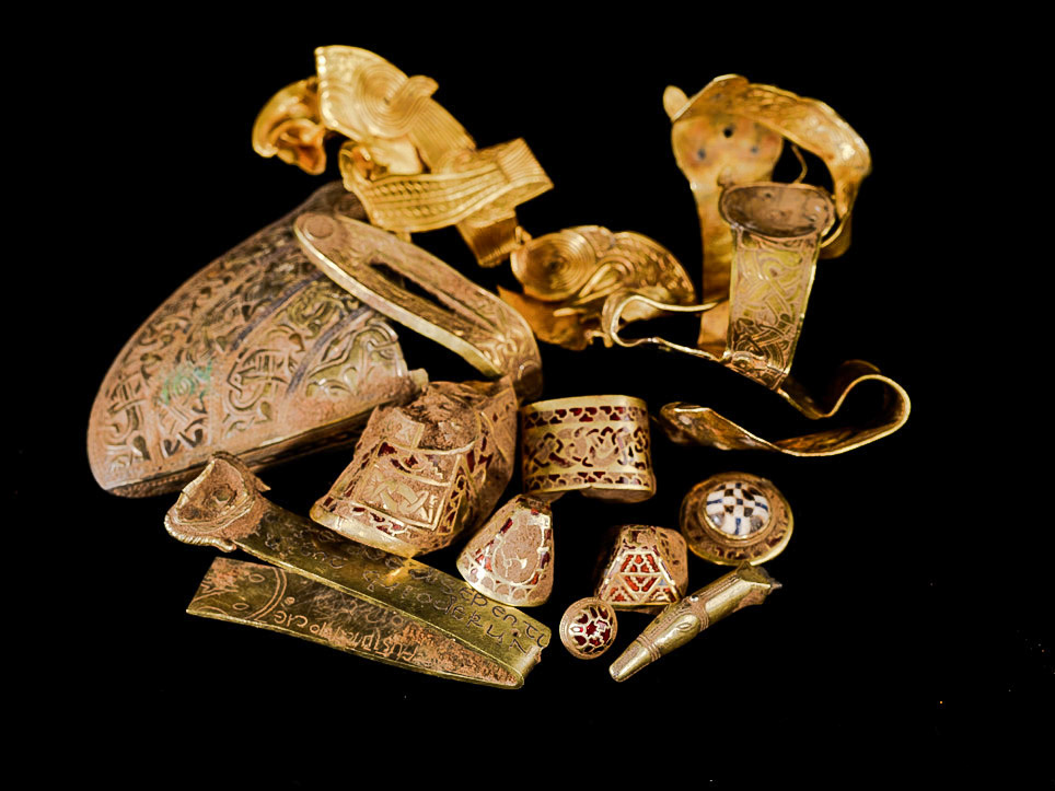
Discovered in a field near the village of Hammerwich, near Lichfield City, in Staffordshire, on 5 July 2009, the Staffordshire Hoard is the largest hoard of Anglo-Saxon gold and silver metalwork ever found. It consists of nearly 4,000 items that are nearly all martial in character. The artefacts have tentatively been dated to the 7th or 8th centuries, placing the origin of the items in the time of the Kingdom of Mercia.
The hoard was valued at £3.285 million, and was purchased by the Birmingham Museum & Art Gallery and the Potteries Museum & Art Gallery where items from the hoard are displayed.
Media
Television
Local news and television programmes are provided by BBC West Midlands and ITV Central. Television signals are received from the Sutton Coldfield transmitter.
Radio
Radio stations for the area are:
BBC Local Radio
- BBC Radio WM
- BBC Radio Derby can also be received Commercial
- Capital Mid-Counties
- Heart West Midlands
- Greatest Hits Radio Birmingham & The West Midlands
- Smooth West Midlands
- Hits Radio Birmingham Community
- Cannock Chase Radio FM, a community radio station that broadcast from Cannock Chase.
Newspapers
Local newspapers are:
- Lichfield Mercury
- Lichfield Live.
References
References
- "Lichfield Local Authority".
- (n.d.). "Lichfield". Collins Dictionary.
- {{cite legislation UK. (1972)
- {{cite legislation UK. (1973)
- "Council History". Lichfield City Council.
- "The Lichfield (Parishes) Order 1980". The National Archives.
- {{London Gazette. (7 November 1980)
- Live, Lichfield. (2023-04-15). "Lichfield District Council to exit local enterprise partnership after changes are confirmed".
- "Council minutes, 13 May 2025".
- (9 May 2019). "All change at Lichfield District Council after Conservatives vote for new leader". Lichfield Live.
- (27 May 2021). "New boss to take helm at Lichfield District Council". Staffordshire Live.
- {{cite legislation UK. (1972)
- Live, Lichfield. (2023-05-05). "No party wins overall control of Lichfield District Council after dramatic count".
- (20 May 2023). "Tories vow to 'work together' with opposition after losing majority in Lichfield". Express and Star.
- "Compositions Calculator". University of Exeter.
- "Lichfield". [[BBC News Online]].
- (14 December 1995). "Obituary: Sir David Lightbown". The Independent.
- (11 May 1995). "And it's the same story in Lichfield". Rugeley Mercury.
- (25 February 2017). "Former leader of Lichfield District Council says area has lost one of the last great local government statesmen". Lichfield Live.
- (18 May 1995). "District's top jobs". Lichfield Mercury.
- (3 December 1998). "Council's leader stands down". Lichfield Mercury.
- (10 December 1998). "It's business as usual, says new Labour leader". Lichfield Mercury.
- (13 May 1999). "Tories in triumph after tense finish". Lichfield Mercury.
- "Council minutes, 11 May 2010".
- (3 May 2019). "Lichfield District Council election results 2019". Birmingham Live.
- "Council minutes, 21 May 2019".
- "Local elections 2023: live council results for England". The Guardian.
- "Your Councillors by Party". Lichfield District Council.
- (3 October 2023). "Second Conservative member of Lichfield District Council switches to become independent". Lichfield Live.
- "Lichfield". Thorncliffe.
- {{NHLE
- (23 October 1987). "Minister's city visit hit by gales". Lichfield Mercury.
- "History of Lichfield District Council House".
- {{cite legislation UK. (2015)
- "Your Councillors".
- "Your MPs". Lichfield District Council.
- "Parish council contact details".
- "MYE1: Population estimates: Summary for the UK, mid-2020".
- "UK Census Data: Lichfield".
- "Heart of the Country Village". Lichfield District Council.
- "The Find". Staffordshire Hoard.
- (1 May 2004). "Sutton Coldfield (Birmingham, England) Full Freeview transmitter".
- "Cannock Chase Radio".
- "Lichfield Live".
This article was imported from Wikipedia and is available under the Creative Commons Attribution-ShareAlike 4.0 License. Content has been adapted to SurfDoc format. Original contributors can be found on the article history page.
Ask Mako anything about Lichfield District — get instant answers, deeper analysis, and related topics.
Research with MakoFree with your Surf account
Create a free account to save articles, ask Mako questions, and organize your research.
Sign up freeThis content may have been generated or modified by AI. CloudSurf Software LLC is not responsible for the accuracy, completeness, or reliability of AI-generated content. Always verify important information from primary sources.
Report