From Surf Wiki (app.surf) — the open knowledge base
Lewis County, Tennessee
County in Tennessee, United States
County in Tennessee, United States
| Field | Value |
|---|---|
| county | Lewis County |
| state | Tennessee |
| flag | Flag of Lewis County, Tennessee.png |
| seal | Seal of Lewis County, Tennessee.png |
| founded | December 23, 1843 |
| named for | Meriwether Lewis |
| seat wl | Hohenwald |
| largest city wl | Hohenwald |
| area_total_sq_mi | 282 |
| area_land_sq_mi | 282 |
| area_water_sq_mi | 0.4 |
| area percentage | 0.1% |
| census yr | 2020 |
| pop | 12582 |
| density_sq_mi | 43 |
| web | www.lewiscountytn.com |
| time zone | Central |
| ex image | Lewis County Courthouse, Tennessee.JPG |
| ex image cap | Lewis County Courthouse, April 2014 |
| ex image size | 200px |
| district | 5th |
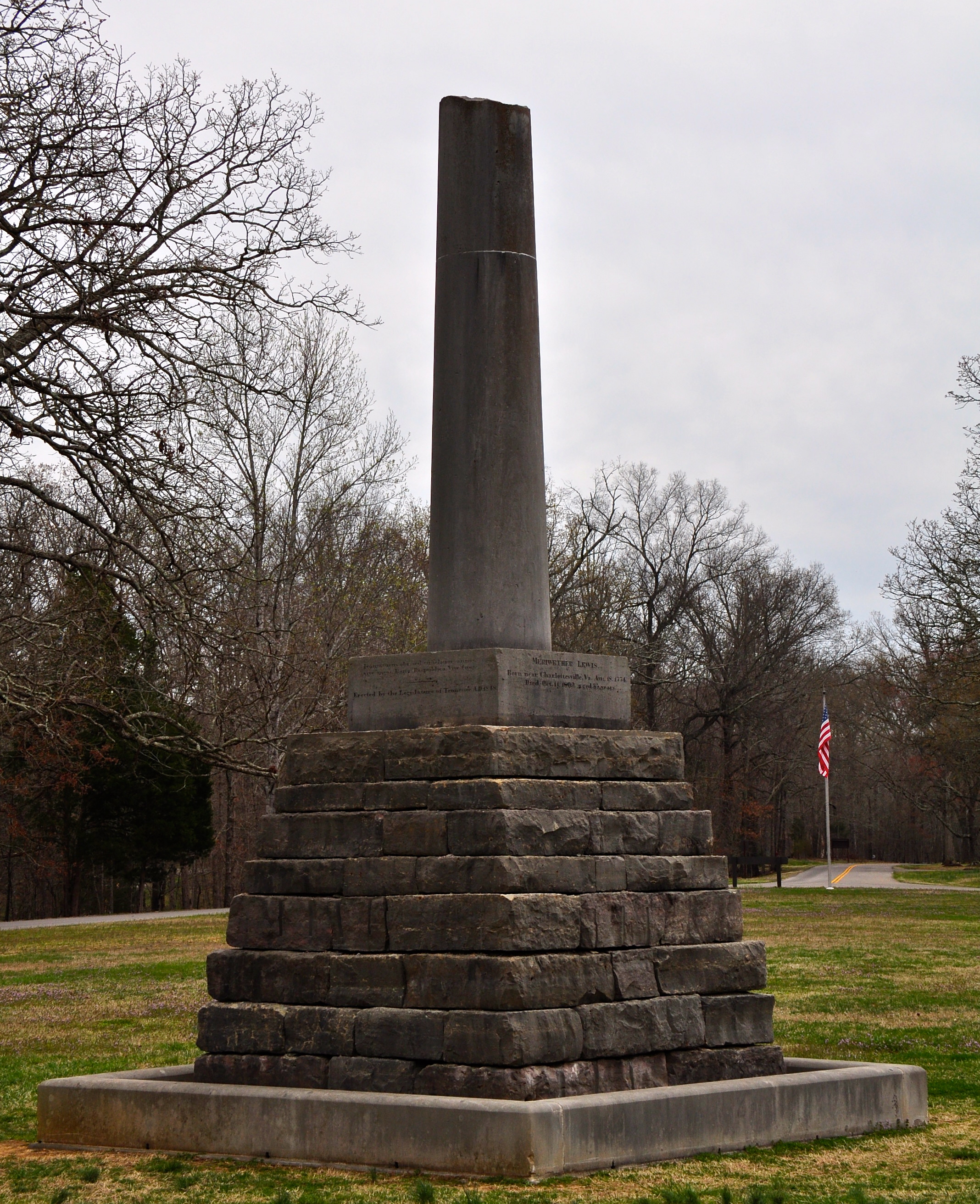
Lewis County is a county located in the U.S. state of Tennessee. As of the 2020 census, the population was 12,582. Its county seat is Hohenwald. The county is named for explorer Meriwether Lewis, who died and was buried at Grinder's Stand near Hohenwald in 1809.
History
Lewis County was formed in 1843 from parts of Perry, Hickman, Lawrence, Maury and Wayne counties. Lewis's grave is located at the geographic center of the county. The bill for its creation was proposed by Powhatan Gordon in the Tennessee State Senate.
On August 10, 1884, a mob attacked a worship service of the Church of Jesus Christ of Latter-day Saints in what is known as the Cane Creek Massacre. Four Latter-day Saints and one member of the mob were killed.
On October 7, 2009, a ceremony was held at the cemetery to commemorate the bicentennial of Meriwether Lewis's death. A bust of Lewis was presented to the National Park Service, which manages the site.
Geography
According to the U.S. Census Bureau, the county has a total area of 282 sqmi, of which 282 sqmi is land and 0.4 sqmi (0.1%) is water.
Adjacent counties
- Hickman County (north)
- Maury County (east)
- Lawrence County (south)
- Wayne County (southwest)
- Perry County (west)
National protected area
- Natchez Trace Parkway (part)
State protected areas
- Auntney Hollow State Natural Area
- Devil's Backbone State Natural Area
- Dry Branch State Natural Area
- Hick Hill Wildlife Management Area
- Langford Branch State Natural Area
- Laurel Hill Wildlife Management Area
- Lewis State Forest
Major highways
Demographics
|align-fn=center 1790-1960 1900-1990 1990-2000 2010-2014
2020 census
| Race | Number | Percentage | White (non-Hispanic) | Black or African American (non-Hispanic) | Native American | Asian | Pacific Islander | Other/Mixed | Hispanic or Latino |
|---|---|---|---|---|---|---|---|---|---|
| 11,510 | 91.48% | ||||||||
| 184 | 1.46% | ||||||||
| 31 | 0.25% | ||||||||
| 55 | 0.44% | ||||||||
| 5 | 0.04% | ||||||||
| 471 | 3.74% | ||||||||
| 326 | 2.59% |
As of the 2020 census, there were 12,582 people, 5,073 households, and 3,175 families residing in the county. The median age was 43.5 years, with 22.5% of residents under the age of 18 and 21.1% aged 65 or older; for every 100 females there were 95.7 males and for every 100 females age 18 and over there were 93.6 males.
The racial makeup of the county was 92.6% White, 1.5% Black or African American, 0.2% American Indian and Alaska Native, 0.4% Asian,
There were 5,073 households in the county, of which 29.0% had children under the age of 18 living in them. Of all households, 48.4% were married-couple households, 18.1% were households with a male householder and no spouse or partner present, and 27.4% were households with a female householder and no spouse or partner present. About 28.8% of all households were made up of individuals and 14.5% had someone living alone who was 65 years of age or older.
There were 5,690 housing units, of which 10.8% were vacant. Among occupied housing units, 75.9% were owner-occupied and 24.1% were renter-occupied. The homeowner vacancy rate was 1.2% and the rental vacancy rate was 4.2%.
2000 census
As of the census of 2000, there were 11,367 people, 4,381 households, and 3,215 families residing in the county. The population density was 40 /mi2. There were 4,821 housing units at an average density of 17 /mi2. The racial makeup of the county was 97.07% White, 1.45% Black or African American, 0.20% Native American, 0.18% Asian, 0.29% from other races, and 0.80% from two or more races. 1.20% of the population were Hispanic or Latino of any race.
There were 4,381 households, out of which 33.20% had children under the age of 18 living with them, 58.90% were married couples living together, 10.70% had a female householder with no husband present, and 26.60% were non-families. 23.50% of all households were made up of individuals, and 10.60% had someone living alone who was 65 years of age or older. The average household size was 2.54 and the average family size was 2.98.
In the county, the population was spread out, with 25.80% under the age of 18, 8.30% from 18 to 24, 27.40% from 25 to 44, 24.80% from 45 to 64, and 13.60% who were 65 years of age or older. The median age was 37 years. For every 100 females there were 96.90 males. For every 100 females age 18 and over, there were 91.80 males.
The median income for a household in the county was $30,444, and the median income for a family was $35,972. Males had a median income of $27,060 versus $19,847 for females. The per capita income for the county was $14,664. About 10.30% of families and 13.40% of the population were below the poverty line, including 16.60% of those under age 18 and 12.20% of those age 65 or over.
Communities
City
- Hohenwald (county seat)
Unincorporated communities
- Buffalo Valley
- Gordonsburg
- Kimmins
Politics
Historically, like all of secessionist Middle Tennessee, Lewis County was overwhelmingly Democratic. Although it did vote for Charles Evans Hughes in 1916 and Warren G. Harding in 1920, Lewis County would be firmly Democratic for the next six decades, being one of only two Tennessee counties to remain loyal to both Hubert Humphrey in 1968 and George McGovern in 1972. Ronald Reagan broke this Democratic sequence with a 177-vote majority over Walter Mondale in his 1984 landslide, but Lewis County would subsequently remain Democratic up to 2000. Since then, however, like much of the rural white South, it has become overwhelmingly Republican due to opposition to the Democratic Party's liberal views on social issues.
Education
The county is served by Lewis County High School.
References
References
- Marjorie Graves, "[http://tennesseeencyclopedia.net/entry.php?rec=782 Lewis County]," ''Tennessee Encyclopedia of History and Culture''. Retrieved: October 21, 2013.
- "Census - Geography Profile: Lewis County, Tennessee". [[United States Census Bureau]].
- "Find a County". National Association of Counties.
- Gannett, Henry. (1905). "The Origin of Certain Place Names in the United States". U.S. Government Printing Office.
- (June 26, 1910). "Lewis. Awful Tragedy Connected With Name of the County". The Tennessean.
- Ricketts, Jeremy R.. (2008). "Tennessee's 1884 "Mormon Massacre" and the Cane Creek Vigilante Movement". Tennessee Historical Quarterly.
- "[http://news.tn.gov/node/2414 First National Memorial Service for Meriwether Lewis] {{webarchive. link. (July 12, 2011 , August 21, 2009. Retrieved: October 21, 2013.)
- (August 22, 2012). "2010 Census Gazetteer Files". United States Census Bureau.
- "U.S. Decennial Census". United States Census Bureau.
- "Historical Census Browser". University of Virginia Library.
- (March 27, 1995). "Population of Counties by Decennial Census: 1900 to 1990". United States Census Bureau.
- (April 2, 2001). "Census 2000 PHC-T-4. Ranking Tables for Counties: 1990 and 2000". United States Census Bureau.
- "State & County QuickFacts". United States Census Bureau.
- "Explore Census Data".
- (2021). "2020 Decennial Census Demographic Profile (DP1)".
- (2021). "2020 Decennial Census Redistricting Data (Public Law 94-171)".
- (2023). "2020 Decennial Census Demographic and Housing Characteristics (DHC)".
- "U.S. Census website". [[United States Census Bureau]].
- Leip, David. "Dave Leip's Atlas of U.S. Presidential Elections".
- Cohn, Nate; [https://www.nytimes.com/2014/04/24/upshot/southern-whites-loyalty-to-gop-nearing-that-of-blacks-to-democrats.html ‘Demographic Shift: Southern Whites’ Loyalty to G.O.P. Nearing That of Blacks to Democrats’], ''[[New York Times]]'', April 24, 2014
This article was imported from Wikipedia and is available under the Creative Commons Attribution-ShareAlike 4.0 License. Content has been adapted to SurfDoc format. Original contributors can be found on the article history page.
Ask Mako anything about Lewis County, Tennessee — get instant answers, deeper analysis, and related topics.
Research with MakoFree with your Surf account
Create a free account to save articles, ask Mako questions, and organize your research.
Sign up freeThis content may have been generated or modified by AI. CloudSurf Software LLC is not responsible for the accuracy, completeness, or reliability of AI-generated content. Always verify important information from primary sources.
Report