From Surf Wiki (app.surf) — the open knowledge base
Lee Valley Reservoir Chain
Chain of 13 reservoirs supplying London

Chain of 13 reservoirs supplying London
The Lee Valley Reservoir Chain is located in the Lee Valley, and comprises 13 reservoirs that supply drinking water to London.
The Reservoir Chain, together with the flood plain which it occupies, is a major geographic constraint; together with the Thames it is one of the two significant topographic features that divide the capital and define the communities on either side. The Lower Lea Valley, downstream of the reservoirs, is more integrated, with better east–west transport connectivity.
Geographic significance
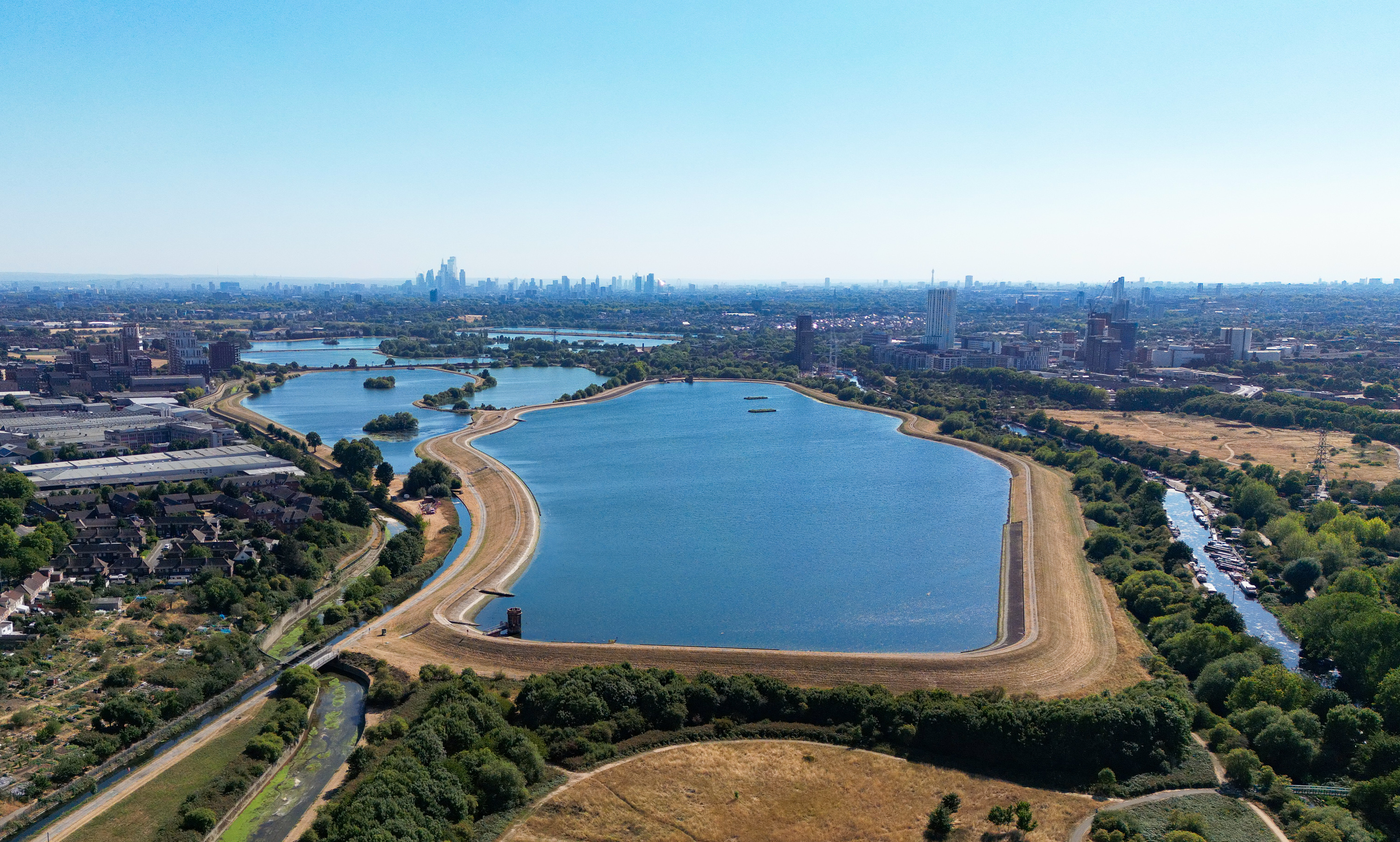
The Chain separates the London Boroughs of Haringey and Enfield to the west, from Waltham Forest and Essex in the east. The corridor includes 13 reservoirs and two to three channels of the Lee, as well as marshes and parkland, up to a mile wide.
During World War I, the settlements on both sides of the Lea were badly hit by German Army and Navy airship raids. It is believed the crews mistook the Reservoir Chain for the Thames and released their bombs on what they took to be central London.
The Boundary Commission treats the Thames and Lea as natural barriers within London. When reviewing the boundaries of London's parliamentary constituencies, it concludes that any constituency spanning either river would be artificial and not reflect local communities or identities. The 2018 review compromised on this, allowing a cross-Lea constituency further south, in the Lower Lea where the communities on each side are more integrated due to the greater quantity and quality of the road and rail links across the valley.
The corridor is part of the Metropolitan Green Belt, and its national and international significance for wildlife is reflected by SSSI, Ramsar and SPA designations. Lying between some of London's most densely populated areas, the Reservoir Chain and associated open land provide a highly valued ecological, landscape and recreational resource for the people of north and east London.
Reservoirs

| Reservoir | Water source (see below) | Water supply | Depth | |||
|---|---|---|---|---|---|---|
| (metres) | Capacity | |||||
| (megalitres) | Chingford Reservoirs (London Borough of Enfield) | Walthamstow Reservoirs (London Borough of Waltham Forest) | ||||
| King George V | River Lea, New River, Lea Diversion | Pumped | 7.5 | 12,500 | ||
| William Girling | Lea Diversion | Pumped | 12.5 | 16,500 | ||
| Banbury | Lea Diversion & Thames-Lee tunnel | Pumped | 8.5 | 2,950 | ||
| Lockwood | Lea Diversion & Thames-Lee tunnel | Pumped | 10.4 | 2,500 | ||
| High Maynard | Lee Diversion, Walthamstow No. 4, East Warwick | Gravity-fed | 5.8 | 680 | ||
| Low Maynard | High Maynard | Gravity-fed | 3.0 | 150 | ||
| Walthamstow No. 4 | High Maynard, Walthamstow No. 5 | Gravity-fed | 5.8 | 590 | ||
| Walthamstow No. 5 | Walthamstow No. 4 | Gravity-fed | 5.8 | 770 | ||
| East Warwick | High Maynard, West Warwick | Gravity-fed | 5.8 | 960 | ||
| West Warwick | East Warwick | Gravity-fed | 5.8 | 800 |
The Chingford Reservoirs are a Site of Special Scientific Interest (SSSI). The Walthamstow Reservoirs, with the exception of Banbury Reservoir, also form an SSSI.
Water supply
The reservoirs are fed by the following waters:
- River Lee Diversion
- River Lee Flood Relief Channel
- New River
- The Thames-Lee Water Main
Water treatment
After being stored in the above reservoirs the water is piped to the Coppermills Water Treatment Works to be treated. In 2006 a smaller water treatment works was also built at Chingford at the edge of the William Girling and King George V reservoirs.
References
References
- "Algae in raw water storage reservoirs: A case study into the effect on rapid gravity filtration".
- Castle, Ian. (2008). "London 1914-17: the Zeppelin menace". Osprey Pub.
- 2018 Boundary Commission proposals for parliamentary constituencies https://boundarycommissionforengland.independent.gov.uk/wp-content/uploads/2018/09/Final-recommendations-report.pdf
- Walthamstow Wetlands SSSI details includes reference to other designations https://designatedsites.naturalengland.org.uk/SiteGeneralDetail.aspx?SiteCode=UK9012111&SiteName=&countyCode=&responsiblePerson=&unitId=&SeaArea=&IFCAArea=
- "Lee Valley Regional Park Authority, Reservoirs".
- [http://www.natureonthemap.naturalengland.org.uk/news.html Natural England, Nature on the Map] (Search on Walthamstow Reservoirs)
- (Feb 1962). "The Thames-Lee Water Main". Proceedings of the Institution of Civil Engineers.
- "Coppermills". Thames Water.
- "Chingford South Water Treatment Works".
This article was imported from Wikipedia and is available under the Creative Commons Attribution-ShareAlike 4.0 License. Content has been adapted to SurfDoc format. Original contributors can be found on the article history page.
Ask Mako anything about Lee Valley Reservoir Chain — get instant answers, deeper analysis, and related topics.
Research with MakoFree with your Surf account
Create a free account to save articles, ask Mako questions, and organize your research.
Sign up freeThis content may have been generated or modified by AI. CloudSurf Software LLC is not responsible for the accuracy, completeness, or reliability of AI-generated content. Always verify important information from primary sources.
Report