From Surf Wiki (app.surf) — the open knowledge base
Lantau Link
Road linking western and central Hong Kong

Road linking western and central Hong Kong
| Field | Value |
|---|---|
| country | HKG |
| type | Route |
| route | 8 |
| name | Lantau Link |
| alternate_name | Part of Route 8 |
| length_km | 4.0 |
| established | 27 April 1997 |
| direction_a | East |
| terminus_a | Tsing Yi |
| junction | 3; |
| [[Image:HK Route3.svg | 22px]] Route 3 at Tsing Yi |
| direction_b | West |
| terminus_b | Lantau (near Tsing Chau Tsai) |
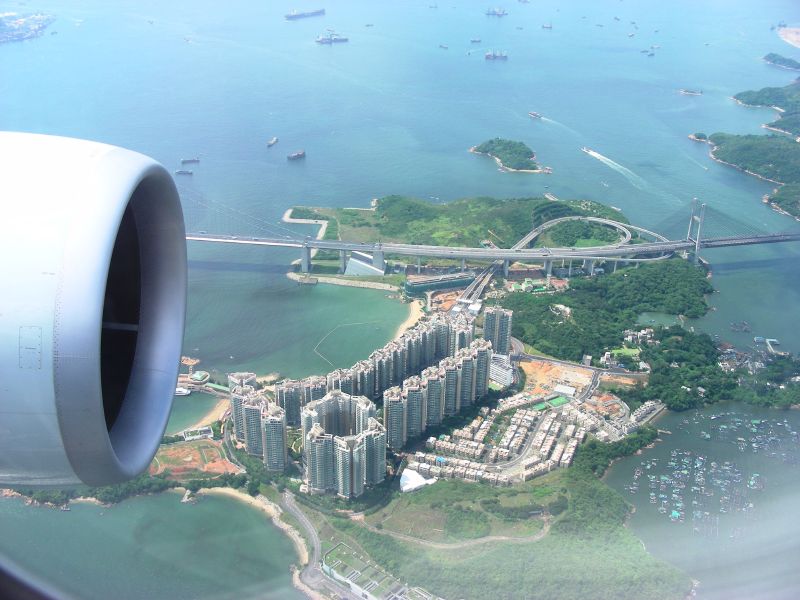
The Lantau Link, formerly known as the Lantau Fixed Crossing, is a roadway in Hong Kong forming part of Route 8 linking Lantau Island to Tsing Yi, from which other roads lead to the urban areas of Kowloon and the rest of the New Territories. It is part of the Airport Core Programme centred on the new Hong Kong International Airport on Lantau. The link was officially opened on 27 April 1997, and it opened to traffic on 22 May the same year.
Infrastructure
The Lantau Link is 3.5 km long and consists of:
- the Tsing Ma Bridge, a suspension bridge linking Tsing Yi to Ma Wan island
- the Ma Wan Viaduct, a viaduct crossing Ma Wan
- the Kap Shui Mun Bridge, a cable-stayed bridge linking Ma Wan to Lantau Island
The link is split into two traffic levels; the upper level is an open, 3-lane divided highway, while the lower level is a double-track railway line used by the MTR Airport Express and Tung Chung line and also contains two single-lane roads for emergency use in both directions. The speed limit is 80 km/h on the upper level and 50 km/h on the lower level. The lower level is generally used only in special circumstances such as strong wind or serious accidents which could lead to the closure of the upper level. The lower level is not connected to Ma Wan.
The Lantau Link is one of the two land passageways connecting Lantau and other parts of Hong Kong; Tuen Mun–Chek Lap Kok Link via Tuen Mun opened on 27 December 2020 as the second land connection, reducing the traffic pressure on Lantau Link.
Near the Tsing Yi end of the Lantau Link is the cable-stayed Ting Kau Bridge, and the Cheung Tsing and Nam Wan tunnels, the latter of which leads to the Stonecutters Bridge. Tsing Yi is also home to the Lantau Link Visitors Centre, a museum and viewing platform for the Lantau Link.
Interchanges
| ''Start '''Lantau Link''''' | - | ''End '''Lantau Link''''' |
|---|---|---|
| continues as North Lantau Highway [[Image:HK Route8.svg | 13px]] |
References
References
- [http://www.info.gov.hk/archive/napco/p-llink.html Government information about the Lantau Link]
- (21 December 2020). "Tolls of Lantau Link to be waived from 0.00am on December 27". Hong Kong Government.
- (24 November 2023). "am專訪|青嶼幹線觀景台活化正收集建議 葵青DO鄧顯權:公眾參與最重要 冀善用潛力搞旺設施".
This article was imported from Wikipedia and is available under the Creative Commons Attribution-ShareAlike 4.0 License. Content has been adapted to SurfDoc format. Original contributors can be found on the article history page.
Ask Mako anything about Lantau Link — get instant answers, deeper analysis, and related topics.
Research with MakoFree with your Surf account
Create a free account to save articles, ask Mako questions, and organize your research.
Sign up freeThis content may have been generated or modified by AI. CloudSurf Software LLC is not responsible for the accuracy, completeness, or reliability of AI-generated content. Always verify important information from primary sources.
Report