From Surf Wiki (app.surf) — the open knowledge base
La Ronge
Northern town in Saskatchewan, Canada
Northern town in Saskatchewan, Canada
| Field | Value |
|---|---|
| official_name | La Ronge |
| settlement_type | Northern town |
| image_skyline | Lac la Ronge island.jpg |
| image_caption | Island on Lac La Ronge |
| pushpin_map | Saskatchewan#Canada |
| pushpin_label_position | |
| pushpin_map_caption | Location of La Ronge in Saskatchewan/Canada |
| pushpin_relief | yes |
| subdivision_type | Country |
| subdivision_name | Canada |
| subdivision_type1 | Province |
| subdivision_name1 | Saskatchewan |
| subdivision_type2 | District |
| subdivision_name2 | Northern Saskatchewan Administration District |
| leader_title1 | MLA Cumberland |
| leader_name1 | Jordan McPhail |
| leader_title2 | MP Desnethé—Missinippi |
| —Churchill River | |
| leader_name2 | Buckley Belanger |
| established_title | Northern village |
| established_date | 3 May 1905 |
| established_title1 | Industrial town |
| established_date1 | 1965 |
| established_title2 | Town |
| established_date2 | 1 November 1976 |
| established_title3 | Northern town |
| established_date3 | 1 October 1983 |
| unit_pref | |
| area_footnotes | |
| area_land_km2 | 16.40 |
| area_urban_km2 | 8.57 |
| population_as_of | 2021 |
| population_footnotes | |
| population_total | 2,521 |
| population_density_km2 | 150.9 |
| population_urban | 5,671 |
| population_density_urban_km2 | 661.9 |
| timezone | CST |
| utc_offset | −6 |
| coordinates | |
| postal_code_type | Postal code |
| postal_code | S0J 1L0 |
| blank_name | Highways |
| blank_info | |
| blank1_name | Post office established |
| blank1_info | 1911 |
| blank2_name | Climate |
| blank2_info | Dfc |
| website | |
| footnotes |
—Churchill River](desnethe-missinippi-churchill-river)
La Ronge is a northern town in the boreal forest of Saskatchewan, Canada. The town is also the namesake of the larger La Ronge population centre, the largest in northern Saskatchewan, comprising the Northern Village of Air Ronge, and the Kitsakie 156B and Lac La Ronge 156 reserves of the Lac La Ronge First Nation.
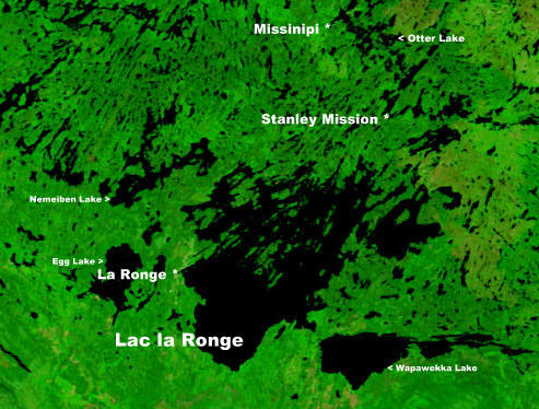
The town is located approximately 250 km north of Prince Albert and lies on the western shore of Lac la Ronge, is adjacent to Lac La Ronge Provincial Park, and is on the edge of the Canadian Shield.
History
The name "La Ronge" comes from the lake itself, although the actual origin of the name is uncertain. The French verb ronger translates as "to gnaw", with at least one explanation theorising that 17th- and 18th-century French fur traders referred to the lake as la ronge (literally, the chewed) due to the abundant beaver population along the lake’s shoreline. Undoubtedly, many of the trees along the water’s edge would have been visibly chewed, or completely gnawed to the ground and taken away by the rodents for their dam construction.
In 1782,{{cite web | access-date = 12 October 2012 }} Swiss born fur trader Jean-Étienne Waddens had a fur trade post on Lac La Ronge.{{cite web | access-date = 12 October 2012 }} In March 1782, Waddens was fatally wounded in a quarrel with his associate Peter Pond.
La Ronge began in 1904 as a fur trading post and meeting place, but with the decline of hunting and the fur market, La Ronge has diversified into other areas. Many of the Dene, Cree, and white trappers used La Ronge as their central service point. It incorporated as a northern village on 3 May 1905.
With the extension of Highway 2 from Prince Albert in 1947, La Ronge became a major tourist fishing area. The highway between La Ronge and Prince Albert expanded the community further in the 1970s after it was paved.
In the early 1950s and 1960s, the mineral resources in the La Ronge area began to be explored and developed.
La Ronge's status changed from northern village to industrial town in 1965 and then to town on 1 November 1976 before finally becoming a northern town on 1 October 1983.
Wildfire evacuations
In May 1999, the community of La Ronge was evacuated after a fire burned through the far north of the town. The wildfire burned multiple houses before conditions pushed the fire away from the town and crews were able to extinguish it.
Once again in July 2015, La Ronge was threatened by dangerous forest fires that combined forcing approximately 7,000 people to evacuate from their homes. Many cabins and homes were burnt. The fire came within 2 km of La Ronge and burned completely around the La Ronge Airport making it difficult to fight the fire from air with smokey conditions and unreliable weather making the fight against the fires very difficult. In total there were over a hundred fires burning in Northern Saskatchewan at once which forced over 13,000 residents to flee their homes, resulting in the province's largest evacuation ever. The fires were caused by low precipitation in the winter and summer months and also high temperatures. | access-date = 12 May 2016}}
Geography
La Ronge is surrounded by several First Nations reserves, with the Northern Village of Air Ronge located just south of the community on Highway 2. With access to all other points north, east and west, and transportation linkage to the south, La Ronge is also the northern hub for the Saskatchewan provincial government.
Climate
According to the Köppen–Geiger and Trewartha climate classification systems, La Ronge experiences a borderline (warm-summer) humid continental climate (Köppen Dfb; Trewartha Dc)—prior to the 1991–2020 normals, it experienced a continental subarctic climate (Köppen Dfc; Trewartha Ec). Winters are long, dry and very cold while summer is short, warm and wetter. Precipitation is fairly low, with an annual average of 513.6 mm. The highest temperature ever recorded in La Ronge was 37.2 C on 23 August 1929, while the coldest temperature ever recorded was -52.2 C on 15 February 1936.
| Jan record high C = 12.5 | Feb record high C = 14.0 | Mar record high C = 17.5 | Apr record high C = 28.0 | May record high C = 33.2 | Jun record high C = 36.1 | Jul record high C = 35.6 | Aug record high C = 37.2 | Sep record high C = 34.4 | Oct record high C = 27.4 | Nov record high C = 18.0 | Dec record high C = 10.6 | year record high C = | Jan record low C = -48.3 | Feb record low C = -52.2 | Mar record low C = -41.8 | Apr record low C = -33.9 | May record low C = -17.6 | Jun record low C = -3.3 | Jul record low C = 0.0 | Aug record low C = -3.4 | Sep record low C = -9.4 | Oct record low C = -20.9 | Nov record low C = -37.6 | Dec record low C = -48.9 | year record low C =
Demographics
In the 2021 Census of Population conducted by Statistics Canada, La Ronge had a population of living in of its total private dwellings, a change of from its 2016 population of . With a land area of 16.71 km2, it had a population density of in 2021.
Population centre
The La Ronge population centre, the fourteenth largest population centre in the province, comprises four adjoining census subdivisions including the Northern Town of La Ronge, the Northern Village of Air Ronge and the Kitsakie 156B and Lac La Ronge 156 Indian reserves of the Lac La Ronge First Nation.
In the 2016 Census, Statistics Canada reported that the La Ronge population centre had a population of 5,671 living in 1,704 of its 1,927 total dwellings, a +6.6% change from its 2011 population of 5,318. With a land area of 8.57 km2, it had a population density of in 2016.
The following is a population breakdown of the La Ronge population centre by census subdivision.
| Census subdivision | 2016 | |||
|---|---|---|---|---|
| population | 2011 | |||
| population | 2006 | |||
| population | Total La Ronge population centre | |||
| Air Ronge | ||||
| Kitsakie 156B | ||||
| La Ronge | ||||
| Lac La Ronge 156 |
Economy
Several mining companies, government agencies, and airlines now keep offices in La Ronge, and the local Chamber of Commerce has many other retail and service businesses amongst its members.
La Ronge Wild Rice Corporation processes freshly harvested wild rice (in August to October) from Northern Saskatchewan farmers.
Tourism also brings in many of people to the La Ronge area. In the summer time, many people visit the Lac La Ronge Provincial Park which is Saskatchewan's largest Provincial Park.
Sports

The community is also home to the La Ronge Ice Wolves ice hockey team of the Saskatchewan Junior Hockey League, La Ronge minor hockey association and the La Ronge Crushers men's hockey league and the La Ronge women's hockey league. La Ronge also has a minor baseball program with many teams and age groups.
La Ronge is home to an 8 team Ladies Slopitch League - JRMCC Ladies Slopitch (slow-pitch softball). The Churchill Community High School and the Senator Myles Venne High School both have many sports programs and partake in the Saskatchewan High School Athletic Association. There are many other sports available in the community including volleyball, broomball, curling and a women's hockey program.
Government
In 2009, La Ronge elected 21-year-old councillor Thomas Sierzycki as its mayor. This established La Ronge as having one of the youngest mayors in Canada. Sierzycki stayed in office for two terms up until October 2016 when he decided not to run for a third term after a failed bid to land himself a seat as a Saskatchewan MLA with the Saskatchewan Party in the April 2016 election.
Education
There are two high schools and three elementary schools in La Ronge and Air Ronge. High schools include Churchill Community High School and / Senator Myles Venne High School. Elementary schools in La Ronge and Air Ronge include Pre-cam Community School, Gordon Denny Community School, and Bells Point Elementary School.
Northlands College maintains its main campus in La Ronge and took over the Nortep / Norpac program after the Saskatchewan provincial government cut funding to the program in March 2017.
Transportation
_Airport.JPG)
La Ronge is connected to southern Saskatchewan by Highway 2, which continues north as Highway 102. La Ronge is served by the La Ronge (Barber Field) Airport and the La Ronge Water Aerodrome.
Notable people
- Danis Goulet, Cree-Métis film director and screenwriter
References
References
- "Search for Municipal Information". Government of Saskatchewan.
- [http://www.municipal.gov.sk.ca/Municipal-History/Northern-Incorporated Northern Communities Incorporation Dates] {{webarchive. link. (20 December 2013)
- White, C.O.. (19 September 2012). "La Ronge". Historica Canada.
- "La Ronge". [[Environment and Climate Change Canada]].
- "La Ronge A". [[Environment Canada]].
- "Lac La Ronge". Environment Canada.
- "La Ronge RCS". Environment Canada.
- "August 1929". Environment Canada.
- "February 1936". Environment Canada.
- (9 February 2022). "Population and dwelling counts: Canada, provinces and territories, census divisions and census subdivisions (municipalities), Saskatchewan". [[Statistics Canada]].
- Cam Fuller, "'Wapawekka' in festival". ''[[Regina Leader-Post]]'', 18 December 2010.
- (2016). "Census Profile: La Ronge, Saskatchewan (Population centre)". Statistics Canada.
- "GeoSearch 2011 - Population Centres (POPCTR)". Statistics Canada.
- (8 February 2012). "Population and dwelling counts, for Canada, provinces and territories, and census subdivisions (municipalities), 2011 and 2006 censuses (Saskatchewan)". [[Statistics Canada]].
- Ragnar Haagen. (5 July 2012). "La Ronge grows larger". paNOW.com.
- (19 September 2012). "Corrections and updates". Statistics Canada.
- (11 April 2012). "Population and dwelling counts, for Canada, provinces and territories, and population centres, 2011 and 2006 censuses (Saskatchewan)". [[Statistics Canada]].
This article was imported from Wikipedia and is available under the Creative Commons Attribution-ShareAlike 4.0 License. Content has been adapted to SurfDoc format. Original contributors can be found on the article history page.
Ask Mako anything about La Ronge — get instant answers, deeper analysis, and related topics.
Research with MakoFree with your Surf account
Create a free account to save articles, ask Mako questions, and organize your research.
Sign up freeThis content may have been generated or modified by AI. CloudSurf Software LLC is not responsible for the accuracy, completeness, or reliability of AI-generated content. Always verify important information from primary sources.
Report