From Surf Wiki (app.surf) — the open knowledge base
La Chapelle, Savoie
| Field | Value |
|---|---|
| name | La Chapelle |
| commune status | Commune |
| image | LA CHAPELLE (1).jpg |
| arrondissement | Saint-Jean-de-Maurienne |
| canton | Saint-Jean-de-Maurienne |
| INSEE | 73074 |
| postal code | 73660 |
| mayor | Charles Costel |
| term | 2023–2026 |
| coordinates | |
| elevation min m | 360 |
| elevation max m | 2200 |
| area km2 | 12.28 |
| population | |
| population date | |
| population footnotes | |
| native name | La Shapéla (Savoyard) |
La Chapelle (; Savoyard: La Shapéla) is a commune in the Savoie department in the Auvergne-Rhône-Alpes region in south-eastern France.
Geography
Climate
In 2010, the climate of the commune was a Type 1, according to a study by the French National Centre for Scientific Research based on a series of data covering the period of 1971–2000. In 2020, Météo-France published a typology of the climates of metropolitan France in which the commune is exposed to a mountain climate and is in the northern Alps climatic region, characterized by an annual rainfall of 1,200 to 1,500 mm, irregularly distributed in summer.
From 1971–2000, the mean annual temperature is 10.5 °C, with an annual temperature range of 19.4 °C. The average annual rainfall total is 1,168 mm, with 9.6 days of precipitation in January and 9 days in July. From 1991–2020, the average annual temperature observed at the nearest Météo-France weather station, "Saint-Alban des Hurtières", in the commune of Saint-Alban-d'Hurtières, 7 km away per great-circle navigation, is 11.0°C and the mean annual precipitation total is 1,274.5 mm. For the future, the municipality's climate parameters estimated for 2050 according to different greenhouse gas emission scenarios can be consulted on a dedicated website published by Météo-France in November 2022.
Urban planning
Typology
As of 1 January 2024, La Chapelle is categorised as a rural commune with dispersed housing, according to the new seven-level municipal density grid defined by INSEE in 2022. It is located outside the urban unit. In addition, the commune is part of the , of which it is a crown commune.In October 2020, the concept of functional areas replaced the old concept of urban areas, to allow consistent comparisons with other countries of the European Union. This area, which includes 26 municipalities, is categorized as an area with fewer than 50,000 inhabitants.
Land use

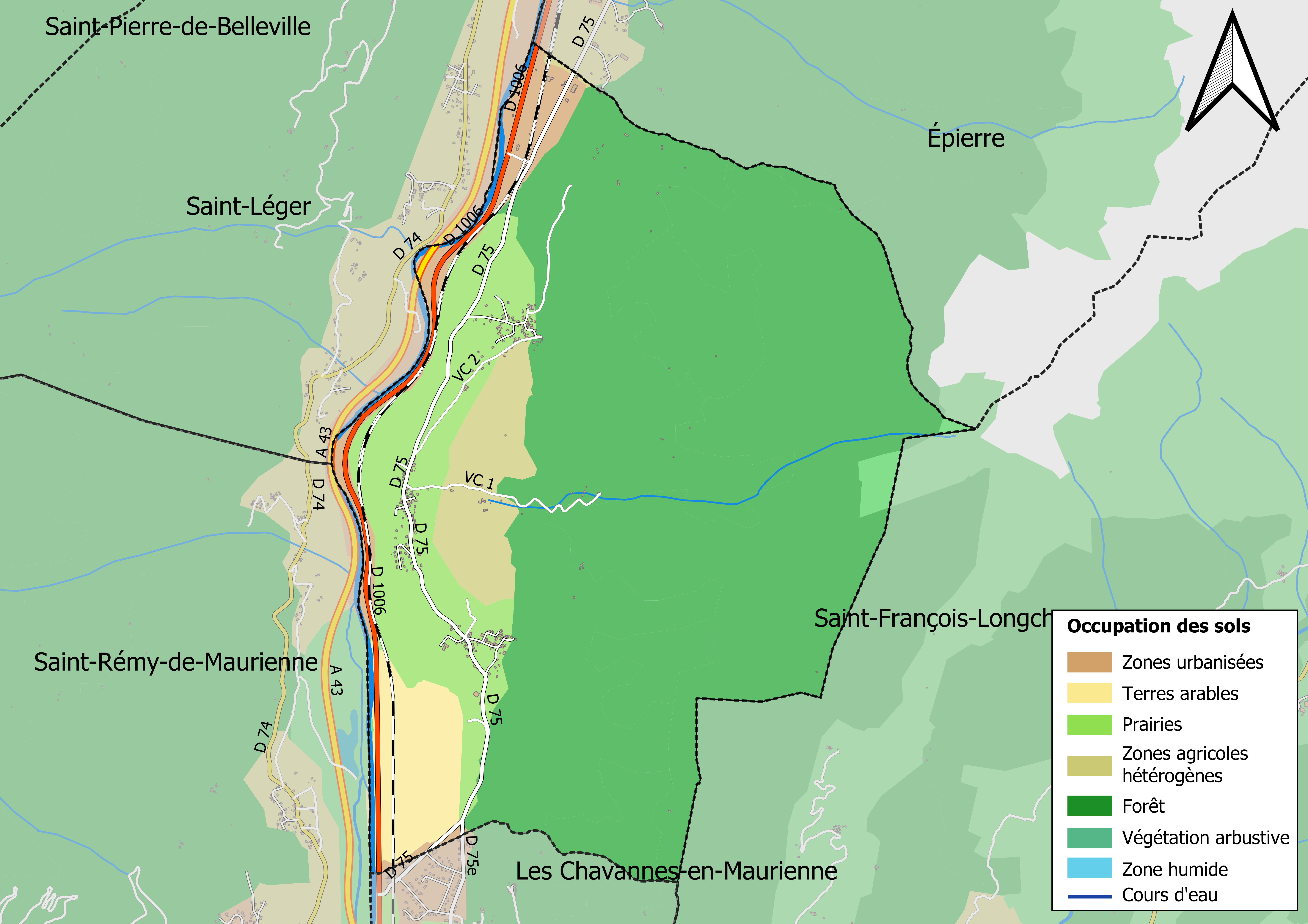
The land use of the municipality, as shown by the European biophysical land cover database (CLC), is marked by the importance of forests and semi-natural environments (72% in 2018), which is decreasing compared to 1990 (73%). The detailed breakdown in 2018 is as follows: forests (70.9%), meadows (13.7%), heterogeneous agricultural areas (4.9%), arable land (4.7%), industrial or commercial areas and communication networks (4.5%), environments with shrub and/or herbaceous vegetation (1.1%), urbanised areas (0.2%).
The IGN also provides an online tool to compare the evolution over time of the land use of the municipality (or territories at different scales). Several eras are available in the form of maps or aerial photos: the Cassini map (18th century), the (1820-1866) and the current period (1950 to the present day).
Notes
References
References
- (6 June 2023). "Répertoire national des élus: les maires". data.gouv.fr, Plateforme ouverte des données publiques françaises.
- Joly, Daniel. (2010-06-18). "Les types de climats en France, une construction spatiale". Cybergeo: European Journal of Geography.
- "Un peu de géographie".
- "Distance between La Chapelle and Saint-Alban-d'Hurtières".
- "Station Météo-France « Saint-Alban des Hurtières », sur la commune de Saint-Alban-d'Hurtières - fiche climatologique - période 1991-2020".
- "Station Météo-France « Saint-Alban des Hurtières », sur la commune de Saint-Alban-d'Hurtières - fiche de métadonnées".
- "CLIMADIAG COMMUNE par Météo-France".
- "La grille de densité 2022".
- "Commune de La Chapelle".
- "Aire d'attraction des villes 2020 de Saint-Jean-de-Maurienne".
- de Bellefon, Marie-Pierre. (2020-10-21). "En France, neuf personnes sur dix vivent dans l’aire d’attraction d’une ville - Insee Focus - 211".
- (2018-12-27). "CORINE Land Cover".
This article was imported from Wikipedia and is available under the Creative Commons Attribution-ShareAlike 4.0 License. Content has been adapted to SurfDoc format. Original contributors can be found on the article history page.
Ask Mako anything about La Chapelle, Savoie — get instant answers, deeper analysis, and related topics.
Research with MakoFree with your Surf account
Create a free account to save articles, ask Mako questions, and organize your research.
Sign up freeThis content may have been generated or modified by AI. CloudSurf Software LLC is not responsible for the accuracy, completeness, or reliability of AI-generated content. Always verify important information from primary sources.
Report