From Surf Wiki (app.surf) — the open knowledge base
Kolozs County
County of the Kingdom of Hungary
County of the Kingdom of Hungary
| Field | Value |
|---|---|
| native_name | |
| conventional_long_name | Kolozs County |
| common_name | Kolozs |
| subdivision | County |
| nation | the Kingdom of Hungary |
| (11th century-1526) | |
| County of the Eastern Hungarian Kingdom | |
| (1526–1570) | |
| County of the Principality of Transylvania | |
| (1570–1867) | |
| County of the Kingdom of Hungary | |
| (1867–1920, 1940–1945) | |
| year_start | 11th century |
| event1 | Treaty of Trianon |
| date_event1 | 4 June 1920 |
| event2 | County recreated (Second Vienna Award) |
| date_event2 | 30 August 1940 |
| event3 | Disestablished |
| date_event3 | 1945 |
| image_coat | Coa_Hungary_County_Kolozs_(history).svg |
| image_map | Kolozs vármegye Magyarországon.svg |
| capital | Kolozsvár |
| coordinates | |
| stat_area1 | 5006 |
| stat_pop1 | 286700 |
| stat_year1 | 1910 |
| today | Romania |
| footnotes | Cluj-Napoca is the current name of the capital. |
(11th century-1526) County of the Eastern Hungarian Kingdom (1526–1570) County of the Principality of Transylvania (1570–1867) County of the Kingdom of Hungary (1867–1920, 1940–1945) Kolozs County was an administrative county (comitatus) of the Kingdom of Hungary, of the Eastern Hungarian Kingdom and of the Principality of Transylvania. Its territory is now in north-western Romania (north-western Transylvania). The capital of the county was Kolozsvár (present-day Cluj-Napoca).
Geography
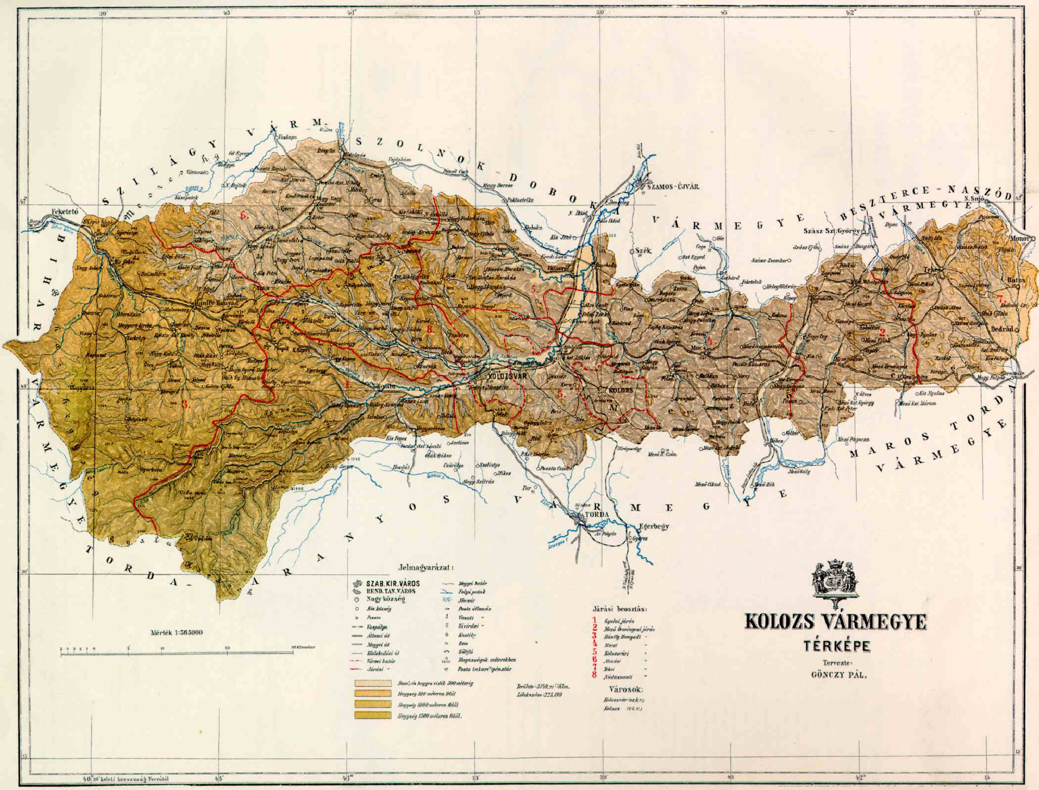
After 1876, Kolozs County shared borders with the Hungarian counties Bihar, Szilágy, Szolnok-Doboka, Beszterce-Naszód, Maros-Torda, and Torda-Aranyos. The rivers Crișul Repede and Someșul Mic flowed through the county. Its area was 5006 km2 in 1910.
History
Kolozs County was formed in the 11th century. In 1876, when the administrative structure of Transylvania was changed, the territory of Kolozs was modified and some villages of Doboka County (which was then disbanded) were annexed to it. In 1920, by the Treaty of Trianon, the county became part of Romania. Following the Second Vienna Award, large part of it was retaken by Hungary in 1940 and the county was recreated; however, after World War II it became part of Romania again. Most of the territory of the county lies in the present Romanian county Cluj, some parts of the county are in the present Romanian counties Sălaj (north-west), Bistrița-Năsăud (north-east), and Mureș (south-east).
Demographics

| Census | Total | Romanian | Hungarian | German | Other or unknown | 1880 | 1890 | 1900 | 1910 |
|---|---|---|---|---|---|---|---|---|---|
| 196,307 | 112,627 (59.31%) | 63,005 (33.18%) | 7,667 (4.04%) | 6,587 (3.47%) | |||||
| 225,199 | 133,277 (59.18%) | 77,271 (34.31%) | 8,081 (3.59%) | 6,570 (2.92%) | |||||
| 253,656 | 146,268 (57.66%) | 95,626 (37.70%) | 9,058 (3.57%) | 2,704 (1.07%) | |||||
| 286,687 | 161,279 (56.26%) | 111,439 (38.87%) | 8,386 (2.93%) | 5,583 (1.95%) |
| Census | Total | Greek Catholic | Calvinist | Eastern Orthodox | Roman Catholic | Jewish | Lutheran | Unitarian | Other or unknown | 1880 | 1890 | 1900 | 1910 |
|---|---|---|---|---|---|---|---|---|---|---|---|---|---|
| 196,307 | 90,265 (45.98%) | 44,525 (22.68%) | 29,110 (14.83%) | 18,016 (9.18%) | 4,782 (2.44%) | 7,380 (3.76%) | 2,083 (1.06%) | 146 (0.07%) | |||||
| 225,199 | 103,681 (46.04%) | 51,213 (22.74%) | 33,281 (14.78%) | 19,972 (8.87%) | 6,727 (2.99%) | 7,700 (3.42%) | 2,515 (1.12%) | 110 (0.05%) | |||||
| 253,656 | 113,136 (44.60%) | 58,297 (22.98%) | 36,578 (14.42%) | 24,821 (9.79%) | 9,858 (3.89%) | 7,864 (3.10%) | 3,020 (1.19%) | 82 (0.03%) | |||||
| 286,687 | 126,217 (44.03%) | 65,910 (22.99%) | 41,715 (14.55%) | 28,427 (9.92%) | 12,581 (4.39%) | 8,167 (2.85%) | 3,331 (1.16%) | 339 (0.12%) |
Subdivisions

In the early 20th century, the subdivisions of Kolozs County were:
| Districts (járás) | District | Capital | Urban counties (törvényhatósági jogú város) | Urban districts (rendezett tanácsú város) |
|---|---|---|---|---|
| Bánffyhunyad | Bánffyhunyad (now Huedin) | |||
| Gyalu | Gyalu (now Gilău) | |||
| Hídalmás | Hídalmás (now Hida) | |||
| Kolozsvár | Kolozsvár (now Cluj) | |||
| Mezőörményes | Mezőörményes (now Urmeniș) | |||
| Mocs | Mocs (now Mociu) | |||
| Nádasment | Kolozsvár (now Cluj) | |||
| Nagysármás | Nagysármás (now Sărmașu) | |||
| Teke | Teke (now Teaca) | |||
| Kolozsvár (now Cluj) | ||||
| Kolozs (now Cojocna) |
Notes
References
References
- "Az 1881. év elején végrehajtott népszámlálás főbb eredményei megyék és községek szerint rendezve, II. kötet (1882)". library.hungaricana.hu.
- "A Magyar Korona országainak helységnévtára (1892)". library.hungaricana.hu.
- "A MAGYAR KORONA ORSZÁGAINAK 1900". library.hungaricana.hu.
- "KlimoTheca :: Könyvtár". Kt.lib.pte.hu.
This article was imported from Wikipedia and is available under the Creative Commons Attribution-ShareAlike 4.0 License. Content has been adapted to SurfDoc format. Original contributors can be found on the article history page.
Ask Mako anything about Kolozs County — get instant answers, deeper analysis, and related topics.
Research with MakoFree with your Surf account
Create a free account to save articles, ask Mako questions, and organize your research.
Sign up freeThis content may have been generated or modified by AI. CloudSurf Software LLC is not responsible for the accuracy, completeness, or reliability of AI-generated content. Always verify important information from primary sources.
Report