From Surf Wiki (app.surf) — the open knowledge base
Kodiak Island Borough, Alaska
Borough in Alaska, United States
Borough in Alaska, United States
| Field | Value |
|---|---|
| county | Kodiak Island Borough |
| state | Alaska |
| ex image | Athena 1 rocket launching from Kodiak Island.jpg |
| ex image size | 220px |
| ex image cap | Athena 1 rocket launching from Kodiak Island |
| seal | Seal of Kodiak Island Borough, Alaska.jpg |
| founded year | 1963 |
| founded date | September 24 |
| founded title | Incorporated |
| seat wl | Kodiak |
| largest city wl | Kodiak |
| area_total_sq_mi | 12022 |
| area_land_sq_mi | 6550 |
| area_water_sq_mi | 5472 |
| area percentage | 45.5% |
| population_as_of | 2020 |
| population_total | 13101 |
| pop_est_as_of | 2024 |
| population_est | 12654 |
| density_sq_mi | auto |
| web | www.kodiakak.us |
| district | At-large |
| time zone | Alaska |
| named for | Kodiak Island |
Kodiak Island Borough is a borough in the U.S. state of Alaska. At the 2020 census, the population was 13,101, down from 13,592 in 2010. The borough seat is Kodiak.
Geography
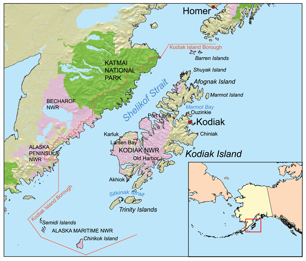
The borough has a total area of 12022 sqmi, of which 6550 sqmi is land and 5472 sqmi (45.5%) is water. Most of the land area belongs to Kodiak Island, but a thin strip of coastal area on the western part of the Alaska Peninsula and other nearby islands (Afognak Island, Shuyak Island, Marmot Island, Raspberry Island, Little Raspberry Island, Whale Island, Spruce Island, Woody Island, Uganik Island, Sitkalidak Island, Tugidak Island, Sitkinak Island, Chirikof Island, and the Semidi Islands) are also in the borough. The waterway between the island and mainland is known as the Shelikof Strait. South of the island are the open waters of the Pacific Ocean, so the site is considered good for launching certain types of satellites. The Kodiak Launch Complex is ideal for putting satellites in Molniya and polar orbits.
Adjacent boroughs
- Kenai Peninsula Borough, Alaska - north
- Lake and Peninsula Borough, Alaska - northwest
National protected areas
- Alaska Maritime National Wildlife Refuge (parts of Alaska Peninsula and Gulf of Alaska units)
- Barren Islands
- Semidi Wilderness
- Semidi Islands
- Trinity Islands
- Sitkinak Island
- Tugidak Island
- Alaska Peninsula National Wildlife Refuge (part)
- Becharof National Wildlife Refuge (part)
- Becharof Wilderness (part)
- Chugach National Forest (part)
- Katmai National Park and Preserve (part)
- Katmai Wilderness (part)
- Kodiak National Wildlife Refuge
Demographics
|align-fn=center 1790-1960 1900-1990 1990-2000 2010-2020
2020 census
| Race / Ethnicity (NH = Non-Hispanic) | title=P004: Hispanic or Latino, and Not Hispanic or Latino by Race – 2000: DEC Summary File 1 – Kodiak Island Borough, Alaska | url=https://data.census.gov/table?g=050XX00US02150&tid=DECENNIALSF12000.P004 | website=United States Census Bureau | access-date= }} | title=P2: Hispanic or Latino, and Not Hispanic or Latino by Race – 2010: DEC Redistricting Data (PL 94-171) – Kodiak Island Borough, Alaska | url=https://data.census.gov/cedsci/table?q=p2&g=050XX00US02150&tid=DECENNIALPL2010.P2 | website=United States Census Bureau | access-date= }} | Pop 2020 | % 2000 | % 2010 | % 2020 |
|---|---|---|---|---|---|---|---|---|---|---|---|---|
| White alone (NH) | 8,001 | 7,137 | 6,291 | 57.51% | 52.51% | 48.02% | ||||||
| Black or African American alone (NH) | 129 | 85 | 85 | 0.93% | 0.63% | 0.65% | ||||||
| Native American or Alaska Native alone (NH) | 1,997 | 1,759 | 1,759 | 14.35% | 12.94% | 13.43% | ||||||
| Asian alone (NH) | 2,193 | 2,620 | 2,781 | 15.76% | 19.28% | 21.23% | ||||||
| Native Hawaiian or Pacific Islander alone (NH) | 105 | 86 | 107 | 0.75% | 0.63% | 0.82% | ||||||
| Other race alone (NH) | 15 | 14 | 74 | 0.11% | 0.10% | 0.56% | ||||||
| Mixed race or Multiracial (NH) | 625 | 895 | 980 | 4.49% | 6.58% | 7.48% | ||||||
| Hispanic or Latino (any race) | 848 | 996 | 1,024 | 6.10% | 7.33% | 7.82% | ||||||
| Total | 13,913 | 13,592 | 13,101 | 100.00% | 100.00% | 100.00% |
As of the 2020 census, the county had a population of 13,101. The median age was 35.2 years. 24.6% of residents were under the age of 18 and 12.3% of residents were 65 years of age or older. For every 100 females there were 114.3 males, and for every 100 females age 18 and over there were 113.3 males age 18 and over.
The racial makeup of the county was 50.1% White, 0.7% Black or African American, 13.9% American Indian and Alaska Native, 21.4% Asian, 0.9% Native Hawaiian and Pacific Islander, 3.0% from some other race, and 10.0% from two or more races. Hispanic or Latino residents of any race comprised 7.8% of the population.
72.7% of residents lived in urban areas, while 27.3% lived in rural areas.
There were 4,612 households in the county, of which 37.2% had children under the age of 18 living with them and 21.6% had a female householder with no spouse or partner present. About 24.6% of all households were made up of individuals and 7.6% had someone living alone who was 65 years of age or older.
There were 5,825 housing units, of which 20.8% were vacant. Among occupied housing units, 56.4% were owner-occupied and 43.6% were renter-occupied. The homeowner vacancy rate was 1.4% and the rental vacancy rate was 10.8%.
2000 census
As of the census of 2000, there were 13,913 people, 4,424 households, and 3,256 families residing in the borough. The population density was 2 /mi2. There were 5,159 housing units at an average density of 1 /mi2. The racial makeup of the borough was 59.69% White, 0.96% Black or African American, 14.58% Native American, 16.04% Asian, 0.79% Pacific Islander, 2.78% from other races, and 5.16% from two or more races. 6.10% of the population were Hispanic or Latino of any race. 13.10% reported speaking Tagalog at home, a language of the Philippines, while 5.28% speak Spanish.
There were 4,424 households, out of which 45.90% had children under the age of 18 living with them, 59.70% were married couples living together, 8.80% had a female householder with no husband present, and 26.40% were non-families. 19.90% of all households were made up of individuals, and 3.70% had someone living alone who was 65 years of age or older. The average household size was 3.07 and the average family size was 3.52.
In the borough the population was spread out, with 32.40% under the age of 18, 8.30% from 18 to 24, 34.00% from 25 to 44, 20.40% from 45 to 64, and 4.80% who were 65 years of age or older. The median age was 32 years. For every 100 females, there were 112.40 males. For every 100 females age 18 and over, there were 117.40 males.
Communities
Cities
- Akhiok
- Kodiak (Borough seat)
- Larsen Bay
- Old Harbor
- Ouzinkie
- Port Lions
Census-designated places
- Aleneva
- Chiniak
- Karluk
- Kodiak Station
- Mill Bay
- Womens Bay
Government and politics
Kodiak Island Borough is strongly Republican, having last voted for a Democrat in 1964.
References
References
- "Government". Kodiak Island Borough.
- (January 1996). "1996 Alaska Municipal Officials Directory". Alaska Municipal League/[[Alaska Department of Commerce, Community and Economic Development.
- "State & County QuickFacts". United States Census Bureau.
- "Find a County". National Association of Counties.
- (February 12, 2011). "US Gazetteer files: 2010, 2000, and 1990". [[United States Census Bureau]].
- "County Population Totals and Components of Change: 2020-2024". United States Census Bureau.
- "U.S. Decennial Census". United States Census Bureau.
- "Historical Census Browser". University of Virginia Library.
- "Population of Counties by Decennial Census: 1900 to 1990". United States Census Bureau.
- "Census 2000 PHC-T-4. Ranking Tables for Counties: 1990 and 2000". United States Census Bureau.
- "P004: Hispanic or Latino, and Not Hispanic or Latino by Race – 2000: DEC Summary File 1 – Kodiak Island Borough, Alaska".
- "P2: Hispanic or Latino, and Not Hispanic or Latino by Race – 2010: DEC Redistricting Data (PL 94-171) – Kodiak Island Borough, Alaska".
- "P2: Hispanic or Latino, and Not Hispanic or Latino by Race – 2020: DEC Redistricting Data (PL 94-171) – Kodiak Island Borough, Alaska".
- (2021). "2020 Decennial Census Demographic Profile (DP1)".
- (2021). "2020 Decennial Census Redistricting Data (Public Law 94-171)".
- (2023). "2020 Decennial Census Demographic and Housing Characteristics (DHC)".
- [http://www.mla.org/map_data_results&state_id=2&county_id=150&mode=geographic&zip=&place_id=&cty_id=&ll=&a=&ea=&order=r], Modern Language Association
- Elections, RRH. "RRH Elections".
This article was imported from Wikipedia and is available under the Creative Commons Attribution-ShareAlike 4.0 License. Content has been adapted to SurfDoc format. Original contributors can be found on the article history page.
Ask Mako anything about Kodiak Island Borough, Alaska — get instant answers, deeper analysis, and related topics.
Research with MakoFree with your Surf account
Create a free account to save articles, ask Mako questions, and organize your research.
Sign up freeThis content may have been generated or modified by AI. CloudSurf Software LLC is not responsible for the accuracy, completeness, or reliability of AI-generated content. Always verify important information from primary sources.
Report