From Surf Wiki (app.surf) — the open knowledge base
KH-9 Hexagon
American family of spy satellites

American family of spy satellites
| Field | Value | |
|---|---|---|
| name | KH-9 HEXAGON | |
| image | KH9 Hexagon integration.png | |
| image_caption | A KH-9 HEXAGON during assembly by Lockheed | |
| mission_type | Imagery intelligence | |
| operator | National Reconnaissance Office | |
| manufacturer | {{plainlist | |
| launch_mass | 11400 kg to 13300 kg (with mapping camera) | |
| dimensions | 16.2 x | |
| launch_rocket | Titan III | |
| launch_site | Vandenberg Air Force Base, SLC-4E | |
| launch_contractor | Martin Marietta | |
| orbit_reference | Sun-synchronous orbit | |
| orbit_regime | Low Earth orbit | |
| orbit_periapsis | 170 km | |
| orbit_apoapsis | 260 km | |
| orbit_inclination | 97° | |
| apsis | gee | |
| telescope_type | folded Wright camera | |
| telescope_diameter | 0.91 m | |
| telescope_focal_length | 1.52 m | |
| telescope_focal_ratio | ||
| telescope_wavelength | visible light, Near-infrared | |
| instruments_list | {{Infobox spaceflight/Instruments | |
| acronym1 | SPC | name1 = Stereo Panoramic Cameras |
| acronym2 | MCS | name2 = Mapping Camera System |
| acronym3 | SI | name3 = Stellar Index camera |
| acronym4 | S3 | name4 = Stellar Solid State Camera |
- Lockheed (satellite vehicle)
- Perkin-Elmer (main camera)
- Itek (stellar and terrain cameras)
- Eastman Kodak (film)
- General Electric (MK V reentry vehicles)
- McDonnell Douglas (MK 8 reentry vehicles)}}
KH-9 (BYEMAN codename HEXAGON), commonly known as Big Bird or KeyHole-9, was a series of photographic reconnaissance satellites launched by the United States between 1971 and 1986. Of twenty launch attempts by the National Reconnaissance Office (NRO), all but one were successful. Photographic film aboard the KH-9 was stored on RCA Astro Electronic Division take up reel system then sent back to Earth in recoverable film return capsules for processing and interpretation. The highest ground resolution achieved by the main cameras of the satellite was 2 ft, though another source says "images in the 'better-than-one-foot' category" for the last "Gambit" missions.
They are officially known as the Broad Coverage Photo Reconnaissance satellites (Code 467). The satellites were built by Lockheed Corporation for the NRO.
The satellites were an important factor in determining Soviet military capabilities and in the acquisition of accurate intelligence for the formulation of U.S. national policy decisions as well as deployment of U.S. forces and weapon systems. The satellites were instrumental in U.S. National Technical Means of Verification of Strategic Arms Limitation Talks (SALT) and the Anti-Ballistic Missile Treaty (ABMT).
The KH-9 was declassified in September 2011 and an example was put on public display for a single day on 17 September 2011 in the parking lot of the Steven F. Udvar-Hazy Center of the National Air and Space Museum.
On 26 January 2012, the National Museum of the United States Air Force put a KH-9 on public display along with its predecessors the KH-7 and KH-8.
Development
KH-9 was, according to many who worked on it, the most sophisticated mechanical satellite in history. It was conceived in the early 1960s as a replacement for the CORONA search satellites. The goal was to search large areas of the Earth with a medium resolution camera. The KH-9 carried two main cameras, although a mapping camera was also carried on several missions. The photographic film from the cameras was sent to recoverable re-entry vehicles and returned to Earth, where the capsules were caught in mid-air by an aircraft. Four re-entry vehicles were carried on most missions, with a fifth added for missions that included a mapping camera.
Between September 1966 and July 1967, the contractors for the Hexagon subsystems were selected. Lockheed Missiles and Space Company (LMSC) was awarded the contract for the Satellite Basic Assembly (SBA), Perkin Elmer for the primary Sensor Subsystem (SS), McDonnell for the Reentry Vehicle (RV), RCA Astro-Electronics Division for the Film Take-Up system, and Itek for the Stellar Index camera (SI). Integration and ground-testing of Satellite Vehicle-1 (SV-1) were completed in May 1971, and it was subsequently shipped to Vandenberg Air Force Base in a 70 ft container. Ultimately, four generations ("blocks") of KH-9 HEXAGON reconnaissance satellites were developed. KH9-7 (missions 7 to 12) was the first to fly a Block-II panoramic camera and SBA. Block-III (missions 13 to 18) included upgrades to electrical distribution and batteries. Two added tanks with ullage control for the Orbit Adjust System (OAS) and new thrusters for the Reaction Control System (RCS) served to increase KH-9's operational lifetime. In addition, the nitrogen supply for the film transport system and the camera vessel was increased. Block-IV (missions 19 and 20) was equipped with an extended command system using plated-wire memory. In the mid 1970s, over 1,000 people in the Danbury, Connecticut area worked on the secret project.
A reentry vehicle from the first Hexagon satellite sank to 16000 ft below the Pacific Ocean after its parachute failed. The retrieved its payload in April 1972 after a lengthy search, but the film had disintegrated during the nine months underwater, leaving no usable photographs.{{cite news
Over the duration of the program, the lifetime of the individual satellites increased steadily. The final KH-9 operated for 275 days. The satellite mass with and without the Mapping Camera System was 13300 and, respectively.
NRO intended to replace HEXAGON with ZEUS, later DAMON—HEXAGON's camera flown on the Space Shuttle—but DAMON was canceled in December 1980. In December 1976 NRO launched the first KH-11 KENNEN. While its electro-optical digital imaging had a smaller field of view than HEXAGON, by not needing film KENNEN was usable for years.
Main KH-9 components
Satellite Control Section
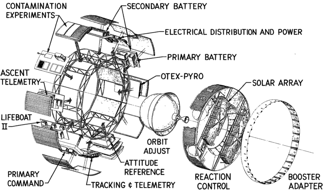
The Satellite Control Section (SCS), which forms the aft part of the SBA, started as Air Force Project 467. SCS was intended as a more capable replacement for the on-orbit propulsion, which had been provided by the Agena upper stage for previous generations of reconnaissance satellites. The SCS featured an increased diameter of 10 ft (compared to 5 ft for the Agena) and a length of 6 ft. It housed hydrazine propellant tanks for the pressure fed Orbital Adjust System (OAS) and the Reaction Control System (RCS). OAS and RCS were connected by a transfer line to facilitate propellant exchange. The tank pressure was maintained within the operational range by additional high pressure nitrogen tanks. The SCS incorporated a freon gas system for backup attitude control inherited from the Agena, commonly referred to as "lifeboat". SCS was equipped with deployable solar panels and an unfurlable parabolic antenna for high data rate communication.
Main camera

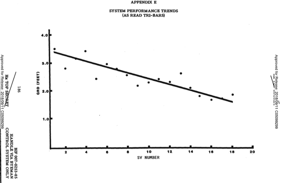
The main camera system was designed by Perkin-Elmer to take stereo images, with a forward looking camera on the port side, and an aft looking camera on the starboard side. Images were taken at altitudes ranging from 90-200 mi. The camera optical layout is an f/3.0 folded Wright camera, with a focal length of 60 in. The system aperture is defined by a 20 in diameter aspheric corrector plate, which corrects the spherical aberration of the Wright design. In each of the cameras the ground image passes through the corrector plate to a 45°-angle flat mirror, which reflects the light to a 0.91 m-diameter concave main mirror. The main mirror directs the light through an opening in the flat mirror and through a four-element lens system onto the film platen. The cameras could scan contiguous areas up to 120° wide, and achieved a ground resolution better than 2 ft during the later phase of the project. Dwayne Allen Day calculated, using disclosed specifications, that HEXAGON was capable of 0.2 m at nadir, and 0.4 m at apogee.
Mapping camera
Missions 1205 to 1216 carried a "mapping camera" (also known as a "frame camera") that used 9 in film and had a moderately low resolution of initially 30 ft, which improved to 20 ft on later missions (somewhat better than LANDSAT). Intended for mapmaking, photos this camera took cover the entire Earth with images between 1973 and 1981. Almost all the imagery from this camera, amounting to 29,000 images, each covering 3400 km2, was declassified in 2002 as a result of Executive order 12951, the same order which declassified CORONA, and copies of the films were transferred to the U.S. Geological Survey's Earth Resources Observation Systems office.
Scientific analysis of declassified KH-9 satellite images continues to reveal historic trends and changes in climate and terrestrial geology. A 2019 study of glacial melt in the Himalayas over the past half-century used data collected by KH-9 satellites throughout the 1970s and 1980s to demonstrate that melt rates had doubled since 1975.
The KH-9 was never a backup project for the KH-10 Manned Orbital Laboratory. It was developed solely as a replacement for the Corona search system.
Reentry vehicles
The forward section of KH-9 housed four McDonnell Douglas Mark 8 satellite reentry vehicles (RV), which were fed film exposed by the main cameras. Each RV had an empty mass of 434 kg. It housed a film take-up assembly (built by RCA Astro Electronic Division) with a mass of 108 kg, and could store about 227 kg of film. The twelve mapping missions were equipped with an additional General Electrics Mark V RV, which could store about 32 kg of film for a total mass of 177 kg.
High-altitude atmospheric density
Missions 1205 to 1207 carried Doppler beacons to help map the atmospheric density at high altitudes in an effort to understand the effect on ephemeris predictions.{{cite journal|title=Atmospheric drag analyses of low-altitude Doppler beacon satellites|year=1976|publisher=New Mexico State University|bibcode=1976sdp..conf..343C|author1=K. S. W. Champion|author2=J. M. Forves|journal=Satellite Doppler Positioning|volume=1
ELINT subsatellites

Missions 1203, 1207, 1208, 1209, and 1212 to 1219 included Ferret ELINT sub-satellites, which were launched into a high Earth orbit to catalogue Soviet air defence radars, eavesdrop on voice communications, and tape missile and satellite telemetry. Missions 1210 to 1212 also included scientific subsatellites.
IRCB (S73-7)
IRCB (Infra-Red Calibration Balloon) was an 66 cm diameter inflatable calibration sphere orbited in the Space Test Program. It was a piggy-back payload on KH9-8 (1208) boosting it to a 500 mile (800 kilometers) circular orbit. It disappeared from ground-based sensors in the 1990s, and was found again in 2024.
KH-9 missions
| Name | url=http://www.nro.gov/foia/declass/GAMHEX/GAMBIT%20and%20HEXAGON%20Histories/7.PDF | title=The HEXAGON story | publisher=National Reconnaissance Office (NRO) | year=1988 | access-date=2011-10-06 | archive-url=https://web.archive.org/web/20120916130448/http://www.nro.gov/foia/declass/GAMHEX/GAMBIT%20and%20HEXAGON%20Histories/7.PDF | archive-date=2012-09-16 | url-status=dead}} | Mission no. | Launch date | NSSDC ID | ||||||
|---|---|---|---|---|---|---|---|---|---|---|---|---|---|---|---|---|---|
| NORAD # | Other Name | Launch vehicle | Orbit | Decay date | |||||||||||||
| KH9-1 | I | 1201 | 15 June 1971 | 1971-056A | |||||||||||||
| 05297 | OPS 7809 | Titan IIID | 184.0 km × 300.0 km, i=96.4° | 6 August 1971 | |||||||||||||
| KH9-2 | I | 1202 | 20 January 1972 | 1972-002A | |||||||||||||
| 05769 | OPS 1737 | Titan IIID | 157.0 km × 331.0 km, i=97.0° | 29 February 1972 | |||||||||||||
| KH9-3 | I | 1203 | 7 July 1972 | 1972-052A | |||||||||||||
| 06094 | OPS 7293 | Titan IIID | 174.0 km × 251.0 km, i=96.9° | 13 September 1972 | |||||||||||||
| KH9-4 | I | 1204 | 10 October 1972 | 1972-079A | |||||||||||||
| 06227 | OPS 8314 | Titan IIID | 160.0 km × 281.0 km, i=96.5° | 8 January 1973 | |||||||||||||
| KH9-5 | I | 1205 | 9 March 1973 | 1973-014A | |||||||||||||
| 06382 | OPS 8410 | Titan IIID | 152.0 km × 270.0 km, i=95.7° | 19 May 1973 | |||||||||||||
| KH9-6 | I | 1206 | 13 July 1973 | 1973-046A | |||||||||||||
| 06727 | OPS 8261 | Titan IIID | 156.0 km × 269.0 km, i=96.2° | 12 October 1973 | |||||||||||||
| KH9-7 | II | 1207 | 10 November 1973 | 1973-088A | |||||||||||||
| 06928 | OPS 6630 | Titan IIID | 159.0 km × 275.0 km, i=96.9° | 13 March 1974 | |||||||||||||
| KH9-8 | II | 1208 | 10 April 1974 | 1974-020A | |||||||||||||
| 07242 | OPS 6245 | Titan IIID | 153.0 km × 285.0 km, i=94.5° | 28 July 1974 | |||||||||||||
| KH9-9 | II | 1209 | 29 October 1974 | 1974-085A | |||||||||||||
| 07495 | OPS 7122 | Titan IIID | 162.0 km × 271.0 km, i=96.7° | 19 March 1975 | |||||||||||||
| KH9-10 | II | 1210 | 8 June 1975 | 1975-051A | |||||||||||||
| 07918 | OPS 6381 | Titan IIID | 157.0 km × 234.0 km, i=96.3° | 5 November 1975 | |||||||||||||
| KH9-11 | II | 1211 | 4 December 1975 | 1975-114A | |||||||||||||
| 08467 | OPS 4428 | Titan IIID | 157.0 km × 234.0 km, i=96.7° | 1 April 1976 | |||||||||||||
| KH9-12 | II | 1212 | 8 July 1976 | 1976-065A | |||||||||||||
| 09006 | OPS 4699 | Titan IIID | 159.0 km × 242.0 km, i=97.0° | 13 December 1976 | |||||||||||||
| KH9-13 | III | 1213 | 27 June 1977 | 1977-056A | |||||||||||||
| 10111 | OPS 4800 | Titan IIID | 155.0 km × 239.0 km, i=97.0° | 23 December 1977 | |||||||||||||
| KH9-14 | III | 1214 | 16 March 1978 | 1978-029A | |||||||||||||
| 10733 | OPS 0460 | Titan IIID | 172.0 km × 218.0 km, i=96.4° | 11 September 1978 | |||||||||||||
| KH9-15 | III | 1215 | 16 March 1979 | 1979-025A | |||||||||||||
| 11305 | OPS 3854 | Titan IIID | 177.0 km × 256.0 km, i=96.3° | 22 September 1979 | |||||||||||||
| KH9-16 | III | 1216 | 18 June 1980 | 1980-052A | |||||||||||||
| 11850 | OPS 3123 | Titan IIID | 169.0 km × 265.0 km, i=96.5° | 6 March 1981 | |||||||||||||
| KH9-17 | III | 1217 | 11 May 1982 | 1982-041A | |||||||||||||
| 13170 | OPS 5642 | Titan IIID | 177.0 km × 262.0 km, i=96.4° | 5 December 1982 | |||||||||||||
| KH9-18 | III | 1218 | 20 June 1983 | 1983-060A | |||||||||||||
| 14137 | OPS 0721 | Titan 34D | 163.0 km × 224.0 km, i=96.4° | 21 March 1984 | |||||||||||||
| KH9-19 | IV | 1219 | 25 June 1984 | 1984-065A | |||||||||||||
| 15063 | USA 2 | Titan 34D | 170.0 km × 230.0 km, i=96.5° | 18 October 1984 | |||||||||||||
| KH9-20 | IV | 1220 | 18 April 1986 | 1986-F03 | Launch failed | Titan 34D | — | — |
(NSSDC ID Numbers: See COSPAR)
Cost
The total cost of the 20 flights KH-9 program from FY1966 to FY1986 was US$3.262 billion in respective year dollars (equivalent to billion in , with an average reference year of 1976).
Specifications
Data source: The Encyclopedia of US Spacecraft and NSSDC
- Launch vehicle: Titan IIID/34D
- Total weight: 11400 kg, with mapping camera 13300 kg
- Reentry weight: 5330 kg
- Max. diameter (main body): 3.05 m
- Length (with mapping camera): 16.21 m
- Orbit: elliptical, 160 x 240 km
- Scanners: television, radio, and high resolution camera
Declassification
The HEXAGON images have been declassified in 2011 as a continuation of Executive Order 12951. The declassified imagery has since been used to conduct Earth observation (EO) by numerous scholars, offering insight into past cultures and climate research. The imagery has been utilized by a team of scientists from Dartmouth College to detect Roman forts in Syria, the Catalan Institute of Classical Archaeology (ICAC) to detect qanat irrigation systems, a team of scientists from Newcastle University to detect desertification and record qanat systems in Skoura Oasis, Morocco and to record qanat systems in Kharga Oasis, Egypt, and a multidisciplinary team of scientists from Italy's Institute of Atmospheric Sciences and Climate (ISAC), Natural Research Council (CNR), Newcastle University, The University of Al-Qadisiyah, and the Italian Space Agency (ASI) to map archaeological sites and ancient irrigation systems and study the climate-water-agriculture-heritage nexus in Southern Iraq.
Gallery
HEXAGON 11.png|The reaction control system of a KH-9, showing the propellant tanks. HEXAGON 12.png|A KH-9 in scaffolding, being prepared for launch. HEXAGON Film being despooled.png|A technician despools one of the re-entry modules which contained the film used by the cameras. HEXAGON Factory to Launch sequence.png|A diagram showing the assembly, testing and launch preparations of a KH-9. HEXAGON Forward section with mapping camera.png|The forward section of a KH-9. HEXAGON Re-entry vehicle.png|A KH-9 re-entry module hanging from its parachute, ready to be retrieved. HEXAGON Reaction Control Module.png|Another view of the KH-9's reaction control system. HEXAGON satellite vehicle transporter.png|A KH-9 being transported by truck in a special canister. HEXAGON Shroud and Base in Acoustic Chamber.png|The shroud and base of a KH-9 undergo vibration tests in an acoustic chamber. KH-9 HEXAGON satellite 2.jpg|This painting of a KH-9 shows the two different camera types that the satellite carried. KH-9 HEXAGON satellite.jpg|Basic specifications and diagram of the KH-9. KH9 HEXAGON profile.png|This diagram shows the various sections of the KH-9 and their dimensions. HEXAGON KH-9 at USAF Museum-1.jpg|A KH-9 at the National Museum of the United States Air Force (front view). HEXAGON KH-9 at USAF Museum-2.jpg|A KH-9 at the National Museum of the United States Air Force (forward section). HEXAGON KH-9 at USAF Museum-3.jpg|A KH-9 at the National Museum of the United States Air Force (film recovery unit). HEXAGON KH-9 at USAF Museum-4.jpg|A KH-9 at the National Museum of the United States Air Force (center section). HEXAGON KH-9 at USAF Museum-5.jpg|A KH-9 at the National Museum of the United States Air Force (left camera). HEXAGON KH-9 at USAF Museum-6.jpg|A KH-9 at the National Museum of the United States Air Force (rear view without solar panels).
References
References
- Yenne, Bill. (1985). "''The Encyclopedia of US Spacecraft''". Exeter Books (A Bison Book), New York.
- (16 December 2012). "34D-9: Titan rocket with last KH-9 explodes after liftoff (18 April 1986) (F)".
- (12 November 2020). "Controlling Hexagon".
- "Assessment of Intelligence Gain Provided by KH-9 over KH-4 and KH-8". NRO.
- "NRO Observes 50th Anniversary with Declassification".
- (18 September 2011). "Declassified US Spy Satellites Reveal Rare Look at Secret Cold War Space Program".
- Doyle, John M., Big Bird, uncaged, Air and Space, December 2011/January 2012, p.10
- Cohen, Aubrey, [http://www.seattlepi.com/business/boeing/article/Three-former-spy-satellites-go-on-display-2736911.php "Three former spy satellites go on display"] ''[[Seattle Post-Intelligencer]]'' 26 January 2012
- (25 December 2011). "Decades Later, a Cold War Secret Is Revealed". Fox News.
- Day, Dwayne Allen. (2019-07-01). "Top Secret DAMON: the classified reconnaissance payload planned for the fourth space shuttle mission".
- Burnett, M.G.. (1982-12-01). "Hexagon (KH-9) Mapping Camera Program and Evolution". NRO.
- Hall, R. Cargill. (1988). "The Air Force and the National Security Space Program 1946 - 1988". USAF Historical Research Center.
- Doyle, John M., Big Bird, uncaged, Air & Space, December 2011/January 2012, p.10
- Gerald K. Haines. (1997). "Critical to US Security: the development of the GAMBIT and HEXAGON satellite reconnaissance system". National Reconnaissance Office (NRO).
- Richard J. Chester. (1985). "A history of the HEXAGON program". National Reconnaissance Office (NRO).
- Day, Dwayne Allen. (2017-01-30). "Black ZEUS: The top secret shuttle mission that never flew".
- "NRO's Review & Redaction Guide (RRG), Version 2, 2012". NRO.
- NARA ARC database description of "Keyhole-9 (KH-9) Satellite Imagery", accession number NN3-263-02-011
- (2002-10-09). "National Archives Releases Recently Declassified Satellite Imagery". National Archives and Records Administration press release.
- (15 October 2002). "NIMA Sponsors Historical Imagery Declassification Conference America's Eyes: What We Were Seeing". SpaceRef.
- Harvey, Chelsea. (2019-06-20). "Cold War Spy Satellites Reveal Substantial Himalayan Glacier Melt". Scientific American.
- Barbara Pope. (2006-04-28). "NIMS file by satellite name". NASA.
- (1975-04-01). "Atmospheric Density Determination from Analysis of Doppler Beacon Satellite Data". Air Force Cambridge Research Labs, Hanscom AFB.
- Scott F. Large. (2002-10-09). "National Reconnaissance Office Review and Redaction Guide: Version 1.0 2008 Edition". NRO.
- (2010-10-08). "1972-052C". NASA.
- (2010-10-08). "1973-088B". NASA.
- (2010-10-08). "1974-020B". NASA.
- (2010-10-08). "1974-020C". NASA.
- (2010-10-08). "1974-085B". NASA.
- (2010-10-08). "1976-065B". NASA.
- (2010-10-08). "1976-065C". NASA.
- (2010-10-08). "1984-065C". NASA.
- Day, Dwayne. (2009-04-27). "Robotic ravens: American ferret satellite operations during the Cold War".
- Krebs, Gunter Dirk. "IRCB (S73-7)".
- Passant Rabie / Gizmodo. (2024-05-01). "A satellite that was lost in space for 25 years has finally been found".
- (1988). "The HEXAGON story". National Reconnaissance Office (NRO).
- (2010-10-08). "KH 9-01 1971-056A". NASA.
- (2010-10-08). "KH 9-02 1972-002A". NASA.
- (2010-10-08). "KH 9-03 1972-052A". NASA.
- (2010-10-08). "KH 9-04 1972-079A". NASA.
- (2010-10-08). "KH 9-05 1973-014 A". NASA.
- (2010-10-08). "KH 9-06 1973-046A". NASA.
- (2010-10-08). "KH 9-07 1973-088A". NASA.
- (2010-10-08). "KH 9-08 1974-020A". NASA.
- (2010-10-08). "KH 9-09 1974-085A". NASA.
- (2010-10-08). "KH 9-10 1975-051A". NASA.
- (2010-10-08). "KH 9-11 1975-114A". NASA.
- (2010-10-08). "KH 9-12 1976-065A". NASA.
- (2010-10-08). "KH 9-13 1977-056A". NASA.
- (2010-10-08). "KH 9-14 1978-029A". NASA.
- (2010-10-08). "KH 9-15 1979-025A". NASA.
- (2010-10-08). "KH 9-16 1980-052A". NASA.
- (2010-10-08). "KH 9-17 1982-041A". NASA.
- (2010-10-08). "KH 9-18 1983-060A". NASA.
- (2010-10-08). "1984-065A 1984-065A". NASA.
- Stern, Richard G.. (2008-08-05). "Reentry Breakup and Survivability Characteristics of the Vehicle Atmospheric Survivability Project (VASP) Vehicles". dtic.mil.
- [[s:Executive Order 12951. Executive Order 12951]]
- (2017). "USGS EROS Archive - Declassified Data - Declassified Satellite Imagery - 3 [Dataset]". U.S. Geological Survey.
- (2024). "Deep learning-based detection of qanat underground water distribution systems using HEXAGON spy satellite imagery". Journal of Archaeological Science.
- (2023-11-08). "Detecting desertification in the ancient oases of southern Morocco". Scientific Reports.
- Makovics, Jennifer Lavris. (April 2024). "2024 IEEE Mediterranean and Middle-East Geoscience and Remote Sensing Symposium (M2GARSS)".
- (2025-05-07). "Environmental Challenges and Vanishing Archaeological Landscapes: Remotely Sensed Insights into the Climate–Water–Agriculture–Heritage Nexus in Southern Iraq". Land.
This article was imported from Wikipedia and is available under the Creative Commons Attribution-ShareAlike 4.0 License. Content has been adapted to SurfDoc format. Original contributors can be found on the article history page.
Ask Mako anything about KH-9 Hexagon — get instant answers, deeper analysis, and related topics.
Research with MakoFree with your Surf account
Create a free account to save articles, ask Mako questions, and organize your research.
Sign up freeThis content may have been generated or modified by AI. CloudSurf Software LLC is not responsible for the accuracy, completeness, or reliability of AI-generated content. Always verify important information from primary sources.
Report