From Surf Wiki (app.surf) — the open knowledge base
Kerikeri
Town in the Northland Region of New Zealand
Town in the Northland Region of New Zealand
| Field | Value |
|---|---|
| name | Kerikeri |
| settlement_type | Town |
| image_skyline | Stone Store and Kemp House.jpg |
| image_caption | The Kerikeri Mission Station, with the Stone Store at left, St James at rear, and Mission House on the right |
| subdivision_type | Country |
| subdivision_name | New Zealand |
| subdivision_type1 | Region |
| subdivision_name1 | Northland Region |
| subdivision_type2 | District |
| subdivision_name2 | Far North District |
| subdivision_type3 | Ward |
| subdivision_name3 | Bay of Islands-Whangaroa |
| subdivision_type4 | Community |
| subdivision_name4 | Bay of Islands-Whangaroa |
| subdivision_type5 | Subdivision |
| subdivision_name5 | Kerikeri |
| leader_title | Territorial Authority |
| leader_name | Far North District Council |
| leader_title1 | Regional council |
| leader_name1 | Northland Regional Council |
| leader_title2 | Mayor of Far North |
| leader_name2 | |
| leader_title3 | Northland MP |
| leader_name3 | |
| leader_title4 | Te Tai Tokerau MP |
| leader_name4 | |
| seat_type | Electorates |
| seat | |
| established_title1 | Settled by Europeans |
| established_date1 | 1814 |
| mapframe | yes |
| mapframe-zoom | 9 |
| coordinates | |
| area_total_km2 | 22.05 |
| area_footnotes | |
| population_total | |
| population_as_of | |
| population_footnotes | |
| population_density_km2 | auto |
| postal_code_type | Postcode(s) |
| postal_code | 0230 |
| mapframe-zoom = 9 Kerikeri () is a town in the Bay of Islands, in the Far North District of the North Island of New Zealand. It lies at the head of Kerikeri Inlet, a northwestern arm of the Bay of Islands, where fresh water of the Kerikeri River enters the Pacific Ocean. It is sometimes called the Cradle of the Nation, as it was the site of the first permanent Christian mission station in the country, and has some of the oldest buildings in the country. It is a rapidly expanding centre of subtropical and allied horticulture.
Naming
The missionaries who established the settlement of Kerikeri initially called it Gloucester Town, but this name did not see continued use. The etymology of Kerikeri is unknown with several origins suggested; one possible origin is from the Māori language verb kerikeri meaning 'to dig'.
History
In , Ngāpuhi conquered the area from another iwi (tribe).
In 1814, Samuel Marsden acquired land at Kerikeri from Hongi Hika for the use of the Church Missionary Society for a payment of forty-eight axes. In 1819, Marsden established the second Church Missionary Society mission in New Zealand at the Kerikeri Basin. The protector of the mission station was the chief Ruatara, a nephew of Hongi Hika. Hongi Hika traded with the missionaries, typically exchanging kūmara for arms and ammunition, which he used in raiding rival tribes. By 1827, Hongi and his followers had left Kerikeri, leaving the missionaries with a much smaller native population to proselytise and educate. The mission closed in 1848 due to a declining Māori population and increasing obsolescence of the settlement in favour of Russell.
Following the departure of the Māori populace many Europeans started obtaining land in the area in the 1840s. By the 1890s, most of the land was part of a sheep and cattle station owned by Thomas Coldham Williams, a son of Henry Williams, one of the original missionaries. In 1927, George Alderton purchased the station. He owned the North Auckland Land Development Corporation and subdivided the station into orchards and forestry land. Today, Kerikeri is one of the largest horticultural areas in Northland.
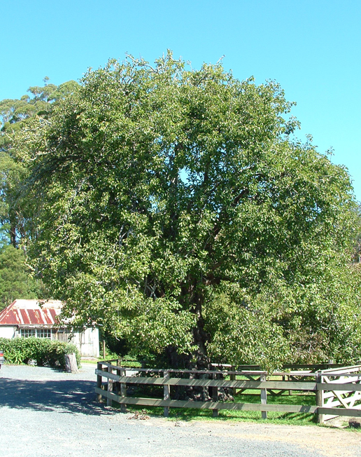
Kerikeri was the first place in New Zealand where grape vines were planted. Marsden planted 100 vines on 25 September 1819 and noted in his journal that New Zealand promised to be very favourable to the vine. In the same year Charlotte Kemp planted the first citrus. New Zealand's first commercial plantings of passionfruit were established in 1927. The plough was first used in New Zealand at Kerikeri, by Rev. J. G. Butler, on 3 May 1820.
Since the 1990s Kerikeri has seen growth spurred by both domestic and international migration.
Geography
Kerikeri is situated at the head of Kerikeri Inlet, a northwestern arm of the Bay of Islands, where fresh water of the Kerikeri River enters the Pacific Ocean.
Demographics
Kerikeri has noticeably different demographics from other towns in the Far North. In 2001, over 90% of residents identified as European compared to just over 40% for both Kawakawa and Kaikohe.
Kerikeri covers 22.05 km2 and had an estimated population of as of with a population density of people per km2.

Kerikeri had a population of 8,070 in the 2023 New Zealand census, an increase of 885 people (12.3%) since the 2018 census, and an increase of 2,064 people (34.4%) since the 2013 census. There were 3,870 males, 4,173 females and 30 people of other genders in 3,336 dwellings. 2.3% of people identified as LGBTIQ+. The median age was 51.4 years (compared with 38.1 years nationally). There were 1,302 people (16.1%) aged under 15 years, 1,014 (12.6%) aged 15 to 29, 3,147 (39.0%) aged 30 to 64, and 2,613 (32.4%) aged 65 or older.
People could identify as more than one ethnicity. The results were 84.8% European (Pākehā); 18.3% Māori; 3.3% Pasifika; 6.4% Asian; 1.1% Middle Eastern, Latin American and African New Zealanders (MELAA); and 2.5% other, which includes people giving their ethnicity as "New Zealander". English was spoken by 97.8%, Māori language by 4.5%, Samoan by 0.4% and other languages by 10.9%. No language could be spoken by 1.5% (e.g. too young to talk). New Zealand Sign Language was known by 0.3%. The percentage of people born overseas was 30.3, compared with 28.8% nationally.
Religious affiliations were 31.7% Christian, 1.4% Hindu, 0.3% Islam, 1.0% Māori religious beliefs, 0.7% Buddhist, 0.5% New Age, 0.2% Jewish, and 1.6% other religions. People who answered that they had no religion were 55.0%, and 7.7% of people did not answer the census question.
Of those at least 15 years old, 1,149 (17.0%) people had a bachelor's or higher degree, 3,549 (52.4%) had a post-high school certificate or diploma, and 1,644 (24.3%) people exclusively held high school qualifications. The median income was $33,700, compared with $41,500 nationally. 627 people (9.3%) earned over $100,000 compared to 12.1% nationally. The employment status of those at least 15 was that 2,643 (39.1%) people were employed full-time, 933 (13.8%) were part-time, and 156 (2.3%) were unemployed.
| Name | Area | |||||||
|---|---|---|---|---|---|---|---|---|
| (km2) | Population | Density | ||||||
| (per km2) | Dwellings | Median age | Median | |||||
| income | New Zealand | 38.1 years | $41,500 | |||||
| Riverview | 7.59 | 2,595 | 342 | 993 | 49.6 years | $36,200 | ||
| Kerikeri Central | 3.71 | 2,661 | 717 | 1,161 | 48.4 years | $29,700 | ||
| Kerikeri South | 10.75 | 2,814 | 262 | 1,182 | 55.0 years | $36,700 |
Historic sites
Kerikeri is home to many historic sites, most are located in the Kerikeri Basin, which is registered as a historic area.
Kororipo pā
Kororipo pā is the remains of a Māori fortified settlement in the Kerikeri Basin. Historically it is known Ngāi Tawake defended the pā in the 1770s; the pa was an important strategical asset as it provided access to the sea. The pā was also the launch place Hongi Hika used in the 1820s for raids on other tribes.
Mission House
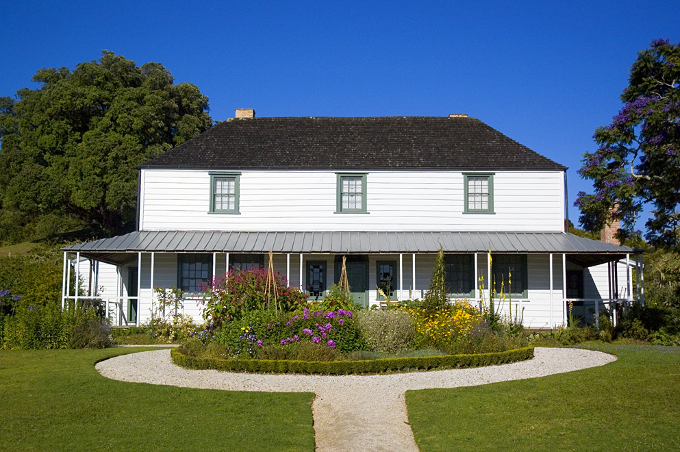
Main article: Mission House
Originally known as the Mission House, and then for more than 100 years Kemp House, but now known as Kerikeri Mission House, it is the oldest extant building in New Zealand.
The two-storey Georgian structure was constructed from 1821 to 1822 by the Church Missionary Society. It was built to house the Reverend John Gare Butler. James Kemp and his family occupied the building in 1832 and the Kemp family continued to live in the house long after the closure of the Kerikeri mission in 1848. The Kemp family continued to live in the building until Ernest Kemp donated the property to the New Zealand Historic Places Trust in 1974.
St. James Church
Main article: St James' Church, Kerikeri
St James Church is a Gothic Revival Anglican church situated on a hillock overlooking the Kerikeri Basin. The church was built in 1878 to replace an earlier chapel constructed in 1829. St James was opened by the Reverend Taua and Archdeacon of Waimate Edward Clarke. In the 1960s St James Church was expanded due to growth in the population of Kerikeri.
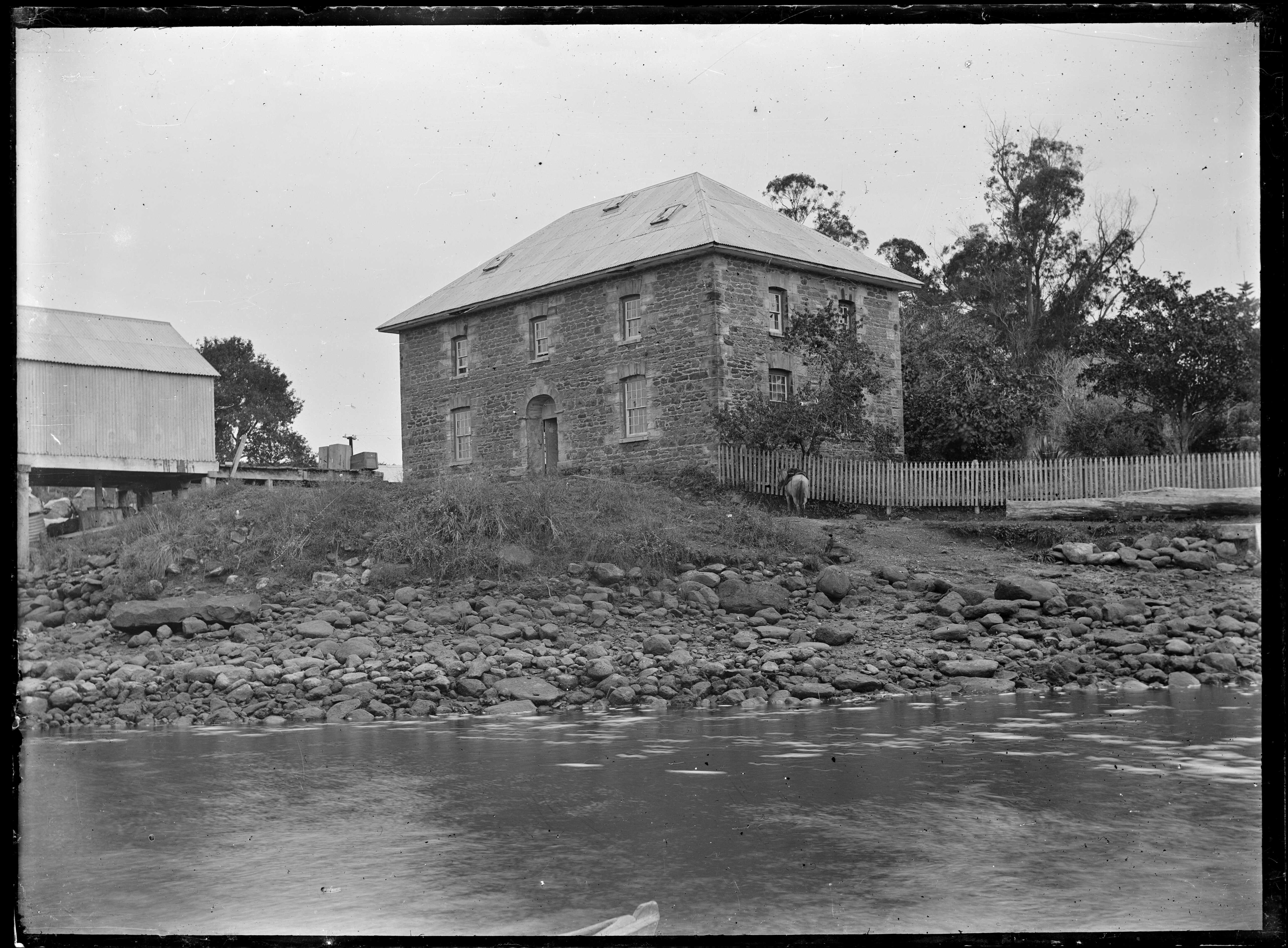
Stone Store

Main article: Stone Store
The Stone Store is New Zealand's oldest extant stone building. The building was constructed in the early 1830s as a warehouse for the Church Missionary Society. The Stone Store was constructed in a Georgian style from basalt and sandstone. It is registered as a category 1 historic building with Heritage New Zealand.
Te Ahurea

Arts and culture
The KOAST (Kerikeri Open Art Studios Trail), which highlights Kerikeri local artists and art galleries, is an annual arts trail held over Labour Weekend since 2014. In 2019 the trail featured 40 artists at 21 studios. The Turner Centre, a performing arts and events venue, opened in 2005. It presents nationally touring events as well as locally produced performances.
Education
Kerikeri High School is the largest school in Northland. A secondary (years 7–13) school, with a roll of
Kerikeri Primary School and Riverview School are contributing primary (years 1–6) schools with rolls of and students.
Springbank School is a private composite (years 1–13) school with a roll of .
Bay of Islands International Academy is a full primary (years 1–8) school with a roll of .
All these schools are coeducational. School rolls are as of .
NorthTec polytechnic also has a campus in Kerikeri.
Airport
Kerikeri Airport, 4.2 km from town at , is called the Bay of Islands Airport. It is served by Air New Zealand and Barrier Air flights from Auckland and has a steadily increasing patronage, handling a record 110,000 passengers in financial 2017/2018. The existing terminal was not fit for purpose and did not meet Air New Zealand's requirements, while growth in passenger numbers also put pressure on the existing facilities. A new $4.75 million terminal opened on 16 June 2019 with improved arrivals/departures, baggage screening and luggage collection facilities.
Climate
| Jan record high C = 34.3 | Feb record high C = 33.2 | Mar record high C = 29.4 | Apr record high C = 29.6 | May record high C = 25.2 | Jun record high C = 21.6 | Jul record high C = 21.9 | Aug record high C = 21.8 | Sep record high C = 26.0 | Oct record high C = 26.4 | Nov record high C = 29.4 | Dec record high C = 30.3 | year record high C = 34.3 |Jan record low C = 4.8 |Feb record low C = 5.3 |Mar record low C = 3.2 |Apr record low C = 1.9 |May record low C = -0.3 |Jun record low C = -1.5 |Jul record low C = -2.0 |Aug record low C = -0.8 |Sep record low C = -0.8 |Oct record low C = 1.7 |Nov record low C = 3.0 |Dec record low C = 3.3 |year record low C = -2.0 |access-date = 20 May 2024}}{{cite web |access-date = 20 June 2024}}{{cite web |access-date = 16 Jan 2025}}
References
See http://en.wikipedia.org/wiki/Wikipedia:Footnotes for a discussion of different citation methods and how to generate footnotes using the and tags
References
- "kerikeri – Māori Dictionary".
- (12 April 2012). "Kerikeri the cradle of New Zealand". [[Northern Advocate]].
- "The Cradle of the Nation Te Kohanga". kerikeri.co.nz.
- {{LINZ. 24972. 24972
- O'Malley, Vincent. (March 2009). "Review: ''Te Kerikeri 1770-1850: The Meeting Pool''". The Journal of the Polynesian Society.
- (1874). "The Life of Henry Williams". [[Early New Zealand Books]] (ENZB), University of Auckland Library.
- (6 June 2008). "St James' Church (Anglican)".
- "The Church Missionary Gleaner, March 1857". [[Adam Matthew Digital]].
- Orange, Claudia. (12 December 2005). "Northland places – Kerikeri".
- Dinsdale, Mike. (8 January 2025). "Northland's multi-million dollar horticulture industry at low risk from Oriental fruit fly". [[Northern Advocate]].
- (1966). "Ploughing".
- (1994). "Discover New Zealand – A Wises Guide". Wises Publications.
- "ArcGIS Web Application".
- {{NZ census 2018. Riverview (102800), Kerikeri Central (103000) and Kerikeri South (103100)
- "Totals by topic for dwellings, (RC, TALB, UR, SA3, SA2, Ward, Health), 2013, 2018, and 2023 Censuses". Stats NZ – Tatauranga Aotearoa – Aotearoa Data Explorer.
- "Totals by topic for individuals, (RC, TALB, UR, SA3, SA2, Ward, Health), 2013, 2018, and 2023 Censuses". Stats NZ – Tatauranga Aotearoa – Aotearoa Data Explorer.
- "Totals by topic for individuals, (RC, TALB, UR, SA3, SA2, Ward, Health), 2013, 2018, and 2023 Censuses". Stats NZ - Tatauranga Aotearoa - Aotearoa Data Explorer.
- "Totals by topic for individuals, (RC, TALB, UR, SA3, SA2, Ward, Health), 2013, 2018, and 2023 Censuses". Stats NZ - Tatauranga Aotearoa - Aotearoa Data Explorer.
- "Totals by topic for individuals, (RC, TALB, UR, SA3, SA2, Ward, Health), 2013, 2018, and 2023 Censuses". Stats NZ - Tatauranga Aotearoa - Aotearoa Data Explorer.
- (1986). "Kerikeri Basin Historic Area Heritage Assessment".
- "Kororipo Pā Historic Walk".
- (11 November 2001). "Kerikeri Mission House".
- (30 October 2001). "Stone Store". Heritage New Zealand.
- (Spring 2024). "Park life". [[Heritage New Zealand]].
- "Kerikeri Open Art Studios Trail".
- "KOAST".
- "About".
- {{TKI. 5. Kerikeri High School
- {{TKI. 1034. Kerikeri Primary School
- {{TKI. 1594. Riverview School
- {{TKI. 436. Springbank School
- {{TKI. 1112. Bay of Islands International Academy
- "Kerikeri". NorthTec.
- (17 June 2019). "New Bay of Islands Airport terminal can cope with 'significant' increase in passengers".
- (2025-03-13). "Barrier Air spreads wings to Bay of Islands to shake-up national carrier".
- ,
This article was imported from Wikipedia and is available under the Creative Commons Attribution-ShareAlike 4.0 License. Content has been adapted to SurfDoc format. Original contributors can be found on the article history page.
Ask Mako anything about Kerikeri — get instant answers, deeper analysis, and related topics.
Research with MakoFree with your Surf account
Create a free account to save articles, ask Mako questions, and organize your research.
Sign up freeThis content may have been generated or modified by AI. CloudSurf Software LLC is not responsible for the accuracy, completeness, or reliability of AI-generated content. Always verify important information from primary sources.
Report