From Surf Wiki (app.surf) — the open knowledge base
Kelburn, New Zealand
Suburb of Wellington City, New Zealand

Suburb of Wellington City, New Zealand
| Field | Value |
|---|---|
| name | Kelburn |
| image | Wellington city with Cable Car.jpg |
| caption1 | View of Wellington Cable Car, Kelburn Park sports field and central business district, from the Botanic Garden |
| location_map | New Zealand Wellington |
| coordinates | |
| city1 | Wellington City |
| council | Wellington City Council |
| ward | |
| established | 1896 |
| area | 143 |
| arearef | |
| population | |
| popsource | |
| popdate | |
| population_density_km2 | auto |
| postcode | 6012 |
| trainstations | Kelburn terminus, Wellington Cable Car |
| mapframe | yes |
| mapframe-zoom | 13 |
| mapframe-zoom = 13
Kelburn is a central suburb of Wellington, the capital city of New Zealand, situated within 1 km of the central business district.
Kelburn sits on the hills just west of the capital's central business district and is bordered by the Botanic Garden and the suburbs of Thorndon and Northland to the north, the suburbs of Karori and Highbury to the south west, and Aro Valley to the south.
Features
The iconic Wellington Cable Car is a tourist attraction and public transport facility. Operating since 1902, it is a funicular railway that ascends from Lambton Quay in the central business district to Kelburn. The Wellington Cable Car Museum is next to its Kelburn terminus.
The Wellington Botanic Garden comprises 25 hectares of native forest, gardens and displays, and has entrances adjacent to the Kelburn terminus of the cable car and on Kelburn's Glen Road.
The main campus of Victoria University of Wellington is in Kelburn, and is home to the category 1 listed Hunter Building, the Adam Art Gallery and the Adam Concert Room. It includes Te Tumu Herenga Waka Marae, a tribal meeting place of the Ngāti Awa hapū of Ngāti Awa ki Poneke.
The Carter Observatory includes a planetarium and exhibition, and is located within the Botanic Garden, close to the Kelburn terminus of the cable car. The cable car also has a university stop next to Kelburn Park, which serves as a university and community sports ground.
Kelburn Village, on Upland Road, houses cafes, restaurants, a pub and local shops. Several embassies and consulates are based in Kelburn, notably the Embassy of the Republic of Indonesia on Glen Road. The entrance to Zealandia, a 225-hectare native forest and wildlife sanctuary is in the West of the suburb.
The Kelburn Viaduct was one of New Zealand's earliest reinforced concrete bridges, and provides vehicle and foot access to Karori and other Western suburbs.
History
The suburb of Kelburn was established after the Upland Estate Company purchased farmland from William Moxham in 1896. It was named after Viscount Kelburn, son of the Governor of New Zealand at the time. Historically Kelburn was also incorrectly spelt as 'Kelburne'.
In 1898, the investors formed a company to build and operate the cable car, to distinguish the nascent suburb from competing residential developments. Kelburn was populated quickly following the opening of the cable car in 1902, with Victoria University's Hunter Building opening in 1904, the Dominion Observatory in 1907, construction of St Michael's Church in 1912, and of Kelburn Normal School in 1914.
Demographics
Kelburn, comprising the statistical areas of Wellington Botanic Gardens, Kelburn and Wellington University, covers 1.43 km2. It had an estimated population of as of with a population density of people per km2.
Kelburn had a population of 4,770 at the 2018 New Zealand census, an increase of 189 people (4.1%) since the 2013 census, and an increase of 483 people (11.3%) since the 2006 census. There were 1,434 households, comprising 2,250 males and 2,523 females, giving a sex ratio of 0.89 males per female, with 390 people (8.2%) aged under 15 years, 2,574 (54.0%) aged 15 to 29, 1,383 (29.0%) aged 30 to 64, and 432 (9.1%) aged 65 or older.
Ethnicities were 87.9% European/Pākehā, 7.2% Māori, 1.9% Pasifika, 9.1% Asian, and 3.0% other ethnicities. People may identify with more than one ethnicity.
The percentage of people born overseas was 28.7, compared with 27.1% nationally.
Although some people chose not to answer the census's question about religious affiliation, 62.5% had no religion, 26.1% were Christian, 0.1% had Māori religious beliefs, 0.6% were Hindu, 0.9% were Muslim, 0.8% were Buddhist and 4.2% had other religions.
Of those at least 15 years old, 2,034 (46.4%) people had a bachelor's or higher degree, and 78 (1.8%) people had no formal qualifications. 1,017 people (23.2%) earned over $70,000 compared to 17.2% nationally. The employment status of those at least 15 was that 1,827 (41.7%) people were employed full-time, 915 (20.9%) were part-time, and 342 (7.8%) were unemployed.
| Name | Area | |||||||
|---|---|---|---|---|---|---|---|---|
| (km2) | Population | Density | ||||||
| (per km2) | Households | Median age | Median | |||||
| income | New Zealand | 37.4 years | $31,800 | |||||
| Wellington Botanic Gardens | 0.53 | 1,119 | 2,111 | 273 | 21.8 years | $12,700 | ||
| Kelburn | 0.50 | 2,157 | 4,314 | 765 | 27.7 years | $37,000 | ||
| Wellington University | 0.42 | 1,494 | 3,557 | 396 | 22.5 years | $16,700 |
Homes in the suburb are among the city's most valuable. As well as homeowners, residents of Kelburn include undergraduate and postgraduate students seeking to live in the vicinity of Victoria University.
Education
Kelburn Normal School is a co-educational state primary school for Year 1 to 8 students, with a roll of as of . The decile 10 school was founded in 1914 as a school for educating primary school teachers, and has a specialist music programme.
Clifton Terrace Model School is a co-educational state primary school for Year 1 to 8 students, with a roll of .
Kelburn is within the enrolment zones for Wellington College, Wellington Girls' College and Wellington High School.
Climate
|Jan record high C = 30.1 |Feb record high C = 30.1 |Mar record high C = 28.3 |Apr record high C = 27.3 |May record high C = 22.0 |Jun record high C = 18.3 |Jul record high C = 17.6 |Aug record high C = 19.3 |Sep record high C = 21.9 |Oct record high C = 25.1 |Nov record high C = 26.9 |Dec record high C = 29.1 |year record high C = 30.1 |Jan record low C = 4.1 |Feb record low C = 5.2 |Mar record low C = 4.6 |Apr record low C = 2.6 |May record low C = 1.0 |Jun record low C = -0.1 |Jul record low C = 0.0 |Aug record low C = -0.1 |Sep record low C = 0.2 |Oct record low C = 1.2 |Nov record low C = 1.7 |Dec record low C = 3.4 |year record low C = -0.1 |access-date = 3 January 2018}}
Boundaries
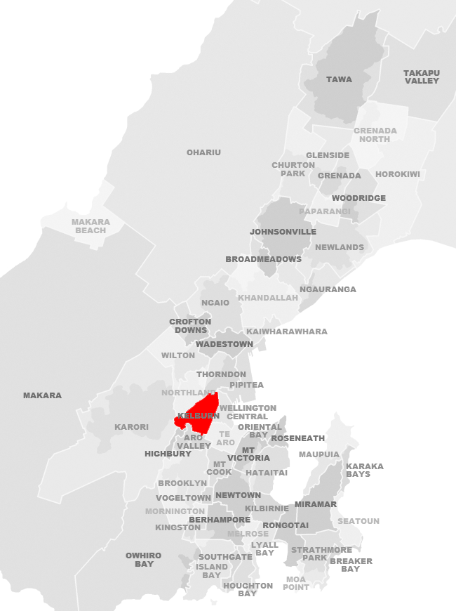
Kelburn's boundaries form an approximate triangle, with the Terrace Tunnel and State Highway 1 defining the eastern boundary, Bowen Street (west of State Highway 1) and Glenmore Street defining the northwestern boundary, and the hills above Aro Valley forming the southern boundary.
Notable people
The northern area of Kelburn near Parliament Buildings and between the Botanic Garden and Kelburn Park has been home to the Todd family, one of New Zealand's wealthiest families. Business leaders Sir Ron Trotter and Lloyd Morrison and prominent lawyers including Sir Kenneth Keith and Sir John McGrath lived in Kelburn. Prominent residents have also included politicians and public figures such as Sir Keith Holyoake and Sir Guy Powles.
References
References
- "Te Kāhui Māngai directory". [[Te Puni Kōkiri]].
- "Māori Maps". Te Potiki National Trust.
- Irvine-Smith, F. L.. (1948). "The Streets of My City: Wellington, New Zealand". A. H. & A. W. Reed.
- "Western suburbs". Te Ara.
- {{cite LINZ. 24898. 24898
- "Wellington Cable Car: History". Wellington Cable Car Limited.
- "Historic Dominion Observatory".
- {{Citation. link. "History". Inside St Mic's. St Michael's Anglican Church, Kelburn
- "ArcGIS Web Application".
- {{NZ census 2018. Wellington Botanic Gardens (251000), Kelburn (251100) and Wellington University (251300)
- {{NZ census place summary 2018. wellington-botanic-gardens. Wellington Botanic Gardens
- {{NZ census place summary 2018. kelburn. Kelburn
- {{NZ census place summary 2018. wellington-university. Wellington University
- Laura Dooney. (5 November 2018). "Nine suburbs in Wellington hit $1m as house values rise". Radio New Zealand.
- (14 November 2011). "Suburb spotlight: Kelburn". Dominion Post.
- "Kelburn Normal School Official School Website".
- "Kelburn Normal School Education Review Office Report". [[Education Review Office]].
- "Kelburn Normal School Ministry of Education School Profile". [[Ministry of Education (New Zealand).
- "Clifton Terrace Model School Official School Website".
- "Clifton Terrace Model School Education Review Office Report". [[Education Review Office]].
- "Clifton Terrace Model School Ministry of Education School Profile". [[Ministry of Education (New Zealand).
- "Wellington City Council, LINZ suburbs map".
- Inder, Richard. (27 February 2006). "Inside the Todd empire". The New Zealand Herald.
- Orsman, Bernard. (31 July 2014). "NBR rich list: Burger baron dining at top table". The New Zealand Herald.
This article was imported from Wikipedia and is available under the Creative Commons Attribution-ShareAlike 4.0 License. Content has been adapted to SurfDoc format. Original contributors can be found on the article history page.
Ask Mako anything about Kelburn, New Zealand — get instant answers, deeper analysis, and related topics.
Research with MakoFree with your Surf account
Create a free account to save articles, ask Mako questions, and organize your research.
Sign up freeThis content may have been generated or modified by AI. CloudSurf Software LLC is not responsible for the accuracy, completeness, or reliability of AI-generated content. Always verify important information from primary sources.
Report