From Surf Wiki (app.surf) — the open knowledge base
Kekaha, Hawaii
| Field | Value |
|---|---|
| official_name | Kekaha |
| native_name | |
| settlement_type | Census-designated place |
| image_skyline | Kekaha beachfront.jpg |
| imagesize | 250px |
| image_caption | Aerial view of Kekaha |
| image_map | Kauai_County_Hawaii_Incorporated_and_Unincorporated_areas_Kekaha_Highlighted.svg |
| map_caption | Location in Kauai County and the state of Hawaii |
| pushpin_map | |
| pushpin_label_position | |
| subdivision_type | Country |
| subdivision_name | United States |
| subdivision_type1 | State |
| subdivision_name1 | Hawaii |
| subdivision_type2 | County |
| subdivision_name2 | Kauai |
| established_title2 | |
| established_title3 | |
| unit_pref | Imperial |
| area_footnotes | |
| area_total_km2 | 3.35 |
| area_land_km2 | 2.60 |
| area_water_km2 | 0.75 |
| area_total_sq_mi | 1.29 |
| area_land_sq_mi | 1.00 |
| area_water_sq_mi | 0.29 |
| population_as_of | 2020 |
| population_total | 3715 |
| population_density_km2 | 1430.32 |
| population_density_sq_mi | 3703.89 |
| timezone | Hawaii-Aleutian |
| utc_offset | -10 |
| coordinates | |
| elevation_m | 3 |
| elevation_ft | 10 |
| postal_code_type | ZIP code |
| postal_code | 96752 |
| area_code | 808 |
| blank_name | FIPS code |
| blank_info | 15-35600 |
| blank1_name | GNIS feature ID |
| blank1_info | 0361086 |
Kekaha (literally, "the place" in Hawaiian) is a census-designated place (CDP) in Kauai County, Hawaii, United States. The population was 3,715 at the 2020 census, up from 3,175 at the 2000 census.
History
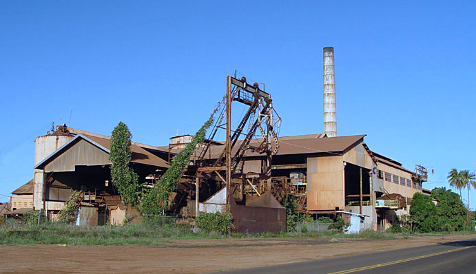
By 1884 a sugar mill (later the Kekaha Sugar Mill) was operating within Kekaha. The mill was jointly owned by Otto Isenberg, Carl Isenberg, Paul Isenberg, Albert Wilcox, G. N. Wilcox, and S. M. Wilcox. By 1898, the Kekaha Sugar Mill Company was merged with other local interests to form the Kekaha Sugar Company.
The sugar mill had a major influence in Kekaha's development, including banking, employment, transportation, housing and utilities such as water and electricity. The mill employed several generations of local families. It closed in 2000 when the entire sugar industry in Hawaii collapsed. The mill was purchased in 2005 by mainland investors who sold off its heavy machinery to other mills as far away as Africa.
Hawaii's first (and only) train robbery occurred here in February 1920, when a masked gunman stopped a slow-moving sugar train and escaped with the locomotive and $11,000 (~$ in ) taken from the labor paymaster on board. Police recovered the money in a swamp near the home of a local fisherman, whose suspicious behavior soon resulted in his arrest and conviction. The fisherman was a big fan of Western movies, and was thought to have been inspired by some of the films he had seen.
Geography
Kekaha is located on the southwest side of the island of Kauai at (21.971690, -159.716290). It is bordered to the east by Waimea and to the south by the Pacific Ocean. Hawaii Route 50 passes through the community, leading northwest 7 mi to its end at the Pacific Missile Range Facility and east 15 mi to Kalaheo.
According to the United States Census Bureau, the Kekaha CDP has a total area of 3.4 km2, of which 2.6 km2 is land and 0.8 km2, or 22.48%, are water.
Climate
According to data from a weather station affiliated with the Pacific Missile Range Facility 7 mi from town, Kekaha has the climate type of the hot semi-arid climate (Köppen: BSh). The annual precipitation is 17.84 in, of which summer is the dry season and winter is the rainy season. December is the wettest month, while August is the driest.
|Jan record high F = 86 |Feb record high F = 87 |Mar record high F = 87 |Apr record high F = 90 |May record high F = 90 |Jun record high F = 93 |Jul record high F = 93 |Aug record high F = 93 |Sep record high F = 93 |Oct record high F = 92 |Nov record high F = 90 |Dec record high F = 88
|Jan avg record high F = 83.1 |Feb avg record high F = 83.1 |Mar avg record high F = 84.7 |Apr avg record high F = 85.7 |May avg record high F = 86.7 |Jun avg record high F = 88.1 |Jul avg record high F = 90.0 |Aug avg record high F = 90.2 |Sep avg record high F = 89.6 |Oct avg record high F = 89.2 |Nov avg record high F = 87.0 |Dec avg record high F = 85.3 |year avg record high F = 91.1
|Jan avg record low F = 58.3 |Feb avg record low F = 58.2 |Mar avg record low F = 59.7 |Apr avg record low F = 61.4 |May avg record low F = 63.8 |Jun avg record low F = 66.7 |Jul avg record low F = 67.8 |Aug avg record low F = 69.2 |Sep avg record low F = 68.4 |Oct avg record low F = 66.9 |Nov avg record low F = 63.9 |Dec avg record low F = 60.9 |year avg record low F = 57.0
|Jan record low F = 54 |Feb record low F = 54 |Mar record low F = 55 |Apr record low F = 57 |May record low F = 59 |Jun record low F = 63 |Jul record low F = 64 |Aug record low F = 65 |Sep record low F = 64 |Oct record low F = 58 |Nov record low F = 57 |Dec record low F = 53
|access-date = June 10, 2023 |archive-url = https://web.archive.org/web/20230610064636/https://www.ncei.noaa.gov/access/services/data/v1?dataset=normals-monthly-1991-2020&stations=USW00022501&format=pdf&dataTypes=MLY-TMAX-NORMAL,MLY-TMIN-NORMAL,MLY-TAVG-NORMAL,MLY-PRCP-NORMAL,MLY-SNOW-NORMAL |archive-date = 2023-06-10 |access-date = June 14, 2023
Demographics
As of the census of 2000, there were 3,175 people, 1,073 households, and 799 families residing in the CDP. The population density was 3,178.2 PD/sqmi. There were 1,162 housing units at an average density of 1,163.2 /mi2. The racial makeup of the CDP was 15.9% White, 0.2% African American, 0.5% Native American, 43.6% Asian, 12.4% Pacific Islander, 1.0% from other races, and 26.4% from two or more races. Hispanic or Latino of any race were 8.7% of the population.
There were 1,073 households, out of which 30.4% had children under the age of 18 living with them, 55.9% were married couples living together, 13.1% had a female householder with no husband present, and 25.5% were non-families. 21.4% of all households were made up of individuals, and 9.4% had someone living alone who was 65 years of age or older. The average household size was 2.96 and the average family size was 3.44.
In the CDP the population was spread out, with 25.1% under the age of 18, 7.5% from 18 to 24, 24.4% from 25 to 44, 27.4% from 45 to 64, and 15.6% who were 65 years of age or older. The median age was 40 years. For every 100 females, there were 98.1 males. For every 100 females age 18 and over, there were 96.2 males.
The median income for a household in the CDP was $41,103, and the median income for a family was $48,629. Males had a median income of $32,969 versus $26,739 for females. The per capita income for the CDP was $17,117. About 10.9% of families and 11.2% of the population were below the poverty line, including 11.8% of those under age 18 and 11.1% of those age 65 or over.
Items of interest

Located near Kekaha is the U.S. Navy Pacific Missile Range Facility (PMRF). Within PMRF's property is located WWVH, the U.S.'s Pacific-region shortwave station operated by NIST broadcasting time signals from an atomic clock. The station also broadcasts weather alerts for portions of the Pacific Ocean. Kekaha Beach Park offers splendid views of Niihau, Hawaii's Forbidden Island.
Education
Hawaii Department of Education operates public schools, including:
- Kekaha Elementary School
Niihau School of Kekaha is a charter K-12 school in Kekaha.
Communications
Circa 1962, the Army Radio Station a few miles west of Kekaha provided ionospheric and tropospheric scatter communications as part of a line of stations from California to Vietnam, sending TTY (Teleprinter) traffic back and forth during the Vietnam War. The radio station was shut down 1967.
References
References
- "2020 U.S. Gazetteer Files". United States Census Bureau.
- Pukui, Mary Kawena. "Place Names of Hawaii". University of Hawaii Press.
- (April 2020}}{{cbignore). "Geographic Identifiers: 2010 Demographic Profile Data (G001): Kekaha CDP, Hawaii". U.S. Census Bureau.
- . (August 2004). ["Register of the KEKAHA SUGAR COMPANY 1880-1946"](https://www2.hawaii.edu/~speccoll/p_kekaha.html). *University of Hawaii Libraries*.
- (2022-02-11). "Train Robbery".
- (2011-02-12). "US Gazetteer files: 2010, 2000, and 1990". [[United States Census Bureau]].
- "Census of Population and Housing". Census.gov.
- "U.S. Census website". [[United States Census Bureau]].
- "Home". Kekaha Elementary School.
This article was imported from Wikipedia and is available under the Creative Commons Attribution-ShareAlike 4.0 License. Content has been adapted to SurfDoc format. Original contributors can be found on the article history page.
Ask Mako anything about Kekaha, Hawaii — get instant answers, deeper analysis, and related topics.
Research with MakoFree with your Surf account
Create a free account to save articles, ask Mako questions, and organize your research.
Sign up freeThis content may have been generated or modified by AI. CloudSurf Software LLC is not responsible for the accuracy, completeness, or reliability of AI-generated content. Always verify important information from primary sources.
Report