From Surf Wiki (app.surf) — the open knowledge base
Kawasaki, Kanagawa
City in Kantō, Japan

City in Kantō, Japan
| Field | Value |
|---|---|
| name | Kawasaki |
| native_name | |
| official_name | Kawasaki City |
| settlement_type | Designated city |
| image_skyline | Kawasaki montage.jpg |
| image_caption | Kawasaki Daishi, Tama River, Lazona Kawasaki Plaza, Musashi-Kosugi area, Todoroki Athletics Stadium, Keihin industrial area |
| image_flag | Flag of Kawasaki, Kanagawa.svg |
| image_seal | 神奈川県川崎市市章.svg |
| mapframe | yes |
| mapframe-zoom | 9 |
| mapframe-point | none |
| map_caption1 | Location of Kawasaki in Kanagawa Prefecture |
| pushpin_map | Japan#Japan Kanto#Japan Kanagawa Prefecture |
| pushpin_label_position | |
| pushpin_map_caption | |
| coordinates | |
| coor_pinpoint | |
| coordinates_footnotes | tags -- |
| subdivision_type | Country |
| subdivision_name | Japan |
| subdivision_type1 | Region |
| subdivision_name1 | Kantō |
| subdivision_type2 | Prefecture |
| subdivision_name2 | Kanagawa Prefecture |
| established_title | First official recorded |
| established_date | late 4th century |
| established_title2 | City Settled |
| established_date2 | July 1, 1924 |
| seat_type | |
| government_footnotes | tags -- |
| leader_title | Mayor |
| leader_name | Norihiko Fukuda |
| leader_name1 | |
| total_type | |
| unit_pref | |
| area_magnitude | |
| area_footnotes | tags -- |
| area_total_km2 | 143.01 |
| elevation_footnotes | tags -- |
| population_footnotes | tags -- |
| population_total | 1,538,262 |
| population_as_of | January 1, 2020 |
| population_density_km2 | auto |
| population_demonym | |
| timezone1 | Japan Standard Time |
| utc_offset1 | +9 |
| area_code_type | |
| blank_name_sec1 | City Symbols |
| blank1_name_sec1 | - Tree |
| blank1_info_sec1 | Camellia |
| blank2_name_sec1 | - Flower |
| blank2_info_sec1 | Azalea |
| blank_name_sec2 | Phone number |
| blank_info_sec2 | 044-200-2111 |
| blank1_name_sec2 | Address |
| blank1_info_sec2 | 1 Miyamoto-chō, Kawasaki-ku, Kawasaki-shi, Kanagawa-ken 210-8577 |
| website |
| mapframe-zoom = 9 | mapframe-point = none
, officially , is a city in Kanagawa Prefecture, Japan, one of the main cities of the Greater Tokyo Area and Keihin Industrial Area. It is the second most populated city in Kanagawa Prefecture after Yokohama, and the eighth most populated city in Japan (including the Tokyo Metropolitan Area).
, the city has an estimated population of 1,503,690, with 716,470 households, and a population density of 10,000 persons per km2. Kawasaki is the only city in Japan with more than one million inhabitants that is not a prefectural capital. The total area is 142.70 km2.
History
Prehistoric and ancient era
Archaeological evidence from the Japanese Paleolithic and Jōmon period can only be found in the northwest Tama Hills. The course of the Tama and the coast of the Bay of Tokyo have also changed in historical times, so that large parts of the urban area are geologically young.
Classical era
Nara period to the Sengoku period
With the introduction of the Ritsuryō legal system, the area came to the Musashi Province in the 7th century. In the Nara period, the center of the Tachibana district was probably in the area of today's Takatsu district. Since the Heian period, the domain of the Inage clan has expanded here. Around the Heiken-ji Buddhist temple (better known as Kawasaki-Daishi), founded in 1128, a monzen-machi, a busy district for the supply of pilgrims, soon emerged. Between the Kamakura period and Sengoku period, smaller feudal lords ruled the area until it finally came under the control of the Later Hōjō clan.
Early modern
In 1611, Koizumi Jidayū had Nikaryō Yōsui built, a canal system on the right bank of the Tama for irrigating the fields, which in some cases still runs through the densely built-up city. On the long-distance Kaidō roads Tōkaidō and Nakaharakaidō built by Edo-Bakufu, stations were built in the area of what would later become Kawasaki, which increased its importance. The Kawasaki station (Kawasaki-juku, near today's Kawasaki station) on the Tōkaidō was not officially recognized until 1623 as the last of the 53 Tōkaidō stations. The Bakufu let the bridges over the Tama collapse and there were ferry connections to nearby Edo in several places in today's Kawasaki, which laid the foundation for the development of the city.
File:Kura-zukuri building kawasaki kanagawa 2014 08 09 250pm.jpg|Old building in the "Kura-zukuri" style on Oyama Kaido street File:Rokugō_no_Watashi_in_the_1860%27s_photographed_by_Felice_Beato.jpg|Rokugō no Watashi in the 1860s photographed by Felice Beato File:東海道五十三次之内_川崎_六郷渡舟-Ferry_Boat_Crossing_the_Rokugo_River_MET_DP122176.jpg|Ferry Boat Crossing the Rokugo River
Modern
The rapid urbanization of the area, which continues to this day, began in the Meiji and Taishō eras. In 1872, Kawasaki Station was established on the Tōkaidō Main Line which was Japan's first railway line. In 1889, the city (machi) Kawasaki in the district (gun) Tachibana was created according to the Japanese municipal system introduced the year before. In 1912 the border between Kanagawa and Tokyo prefectures was established as the Tama River. On July 1, 1924, the independent city (shi-) of Kawasaki with 48,394 inhabitants was formed through a merger with the city of Daishi (formerly Daishigawara) and the village of Miyuki.
People from the Korean peninsula were made to work in the industrial sector in the city, working on railways construction, or rebuilding roads damaged by U.S. bombings towards the end of WWII. People from Okinawa were also coming to the city, and in 1924, the oldest Okinawans Association in Japan was founded in Kawasaki.
World War II
As part of World War II, the city was bombed three times by the United States Army Air Forces (USAAF) between April 1945 and July 1945. The most serious attack was an area bombing with Napalm bombs on April 15, 1945. The attacks destroyed around 35% of the urban area and claimed 1,520 dead and 8,759 injured. The attacks burned down 9.3 km2 of the city (see Bombing of Tokyo). Kawasaki became a target of the first mainland bombing by the US military in 1942, followed by multiple bombings, partly due to the city's heavy and chemical industrial complex supplying the war efforts in Asia and the Pacific.
Contemporary period
Shōwa era (1945–1989)
On April 15, 1945, large parts of the area around the train station and the industrial area at the port were destroyed by air raids. Since the 1950s, residential areas for commuters have been created in the northeastern part of the city, which are connected directly to the centers of Tokyo by new railway lines. On April 1, 1972, Kawasaki became a decree-designated city (seirei shitei toshi) with 5 districts. 1973 the population exceeded the million mark. In 1982 the new districts of Miyamae and Asao were created by splitting off from the districts of Takatsu and Tama. In the course of deindustrialization, industrial areas have recently been increasingly converted into residential areas (mostly Multi-family residential), so that a further increase in population density can be expected.
Geography

Climate
According, to the Köppen Climate Classification, it is a humid subtropical climate (Cfa). {{Weather box | Jan record high C = | Feb record high C = | Mar record high C = | Apr record high C = | May record high C = | Jun record high C = | Jul record high C = | Aug record high C = | Sep record high C = | Oct record high C = | Nov record high C = | Dec record high C = | year record high C = | Jan avg record high C = | Feb avg record high C = | Mar avg record high C = | Apr avg record high C = | May avg record high C = | Jun avg record high C = | Jul avg record high C = | Aug avg record high C = | Sep avg record high C = | Oct avg record high C = | Nov avg record high C = | Dec avg record high C = | year avg record high C = | Jan avg record low C = | Feb avg record low C = | Mar avg record low C = | Apr avg record low C = | May avg record low C = | Jun avg record low C = | Jul avg record low C = | Aug avg record low C = | Sep avg record low C = | Oct avg record low C = | Nov avg record low C = | Dec avg record low C = | year avg record low C = | Jan record low C = | Feb record low C = | Mar record low C = | Apr record low C = | May record low C = | Jun record low C = | Jul record low C = | Aug record low C = | Sep record low C = | Oct record low C = | Nov record low C = | Dec record low C = | year record low C = | Jan snow depth mm = | Feb snow depth mm = | Mar snow depth mm = | Apr snow depth mm = | May snow depth mm = | Jun snow depth mm = | Jul snow depth mm = | Aug snow depth mm = | Sep snow depth mm = | Oct snow depth mm = | Nov snow depth mm = | Dec snow depth mm = | year snow depth mm = | Jan snow depth cm = | Feb snow depth cm = | Mar snow depth cm = | Apr snow depth cm = | May snow depth cm = | Jun snow depth cm = | Jul snow depth cm = | Aug snow depth cm = | Sep snow depth cm = | Oct snow depth cm = | Nov snow depth cm = | Dec snow depth cm = | year snow depth cm = | Jan dew point C = | Feb dew point C = | Mar dew point C = | Apr dew point C = | May dew point C = | Jun dew point C = | Jul dew point C = | Aug dew point C = | Sep dew point C = | Oct dew point C = | Nov dew point C = | Dec dew point C =
Location
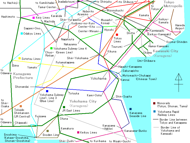
Kawasaki is located on the right bank of the Tama River, which flows into the Tokyo Bay here. The city lies like a narrow band between Tokyo in the northeast and Yokohama in the southwest. The city connects the two major cities and is part of the Greater Tokyo Area, the largest and most densely populated urban area in the world.
The eastern area along the coast of Tokyo Bay is a densely populated industrial zone, part of the Keihin Industrial Zone. In contrast, the western districts in the Tama Hills consist largely of residential areas for commuters in the Tokyo / Yokohama region.
Wards
Kawasaki has seven wards (ku):
| Name | Color | Map of Kawasaki | Rōmaji | Kanji |
|---|---|---|---|---|
| 1 | Asao-ku | 麻生区 | Leaf green | |
| 2 | Kawasaki-ku | |||
| (administrative center) | 川崎区 | Lime green | ||
| 3 | Miyamae-ku | 宮前区 | Orange | |
| 4 | Nakahara-ku | 中原区 | Blue | |
| 5 | Saiwai-ku | 幸区 | Teal | |
| 6 | Takatsu-ku | 高津区 | Purple | |
| 7 | Tama-ku | 多摩区 | Pink |
Adjacent cities and towns
In the northeast, Kawasaki borders the Special wards of Tokyo (starting at Tokyo Bay) Ōta and Setagaya, in the northwest the cities (-shi) belonging to Tokyo Prefecture (-shi) Komae, Chofu, Machida, Inagi, Tama enclose the place. The opposite southwest side is entirely occupied by the districts of Tsurumi, Kōhoku, Tsuzuki and Aoba in the city of Yokohama. With the completion of the Tokyo Bay Aqua-Line, the city of Kisarazu, located on the opposite side of the Tokyo Bay in Chiba Prefecture, also became a neighbor in December 1997.
Bodies of water
Two rivers cross the urban area. The Tama unites with the tributaries Misawa, Yamashita, Gotanda, Nikaryō main river and Hirase; Katahira, Asao, Shimpukuji, Arima, E, Shibu and Yagami flow into the Tsurumi.
The land on the coast of the city is crossed by a network of canals (Tama Canal, Suehiro Canal, Chidori Canal, Yakō Canal, Daishi Canal, Mizue Canal, Shiohama Canal, Iriesaki Canal, Asano Canal, Ikegami Canal, Minami-Watarida Canal, Tanabe Canal, Shiraishi Canal and the Sakai Canal). In addition, the historic Nikaryō Yōsui canal still exists in the hinterland.
Demographics
Per Japanese census data, the population of Kawasaki has seen sustained growth over the past 70 years. | 1940 | 300,777 | 1945 | 252,923 | 1950 | 319,226 | 1960 | 445,520 | 1965 | 632,975 | 1970 | 854,866 | 1975 | 973,497 | 1980 | 1,014,951 | 1985 | 1,088,624 | 1990 | 1,173,603 | 1995 | 1,202,820 | 2000 | 1,249,905 | 2005 | 1,327,011 | 2010 | 1,425,678 | 2015 | 1,475,213 | 2020 | 1,538,262
Politics and government
Kawasaki is governed by Mayor Norihiko Fukuda, an independent elected on 27 October 2013. The city assembly has 63 elected members. Mayor Fukuda was re-elected to a second term in office on 22 October 2017 with support from LDP and Kōmeitō against former municipal MP Akiko Yoshizawa and JCP-supported former primary school teacher Hirokazu Ichiko.
The 60-member city parliament of Kawasaki was re-elected in the unified elections in April 2023. The LDP won 17 seats and is the largest party in the assembly.
Kawasaki was in June 2008 the second Japanese "government-designated city" (seirei shitei toshi) after Hiroshima, which allowed foreigners to participate in municipal referendums.
In the 105-member prefectural parliament of Kanagawa, the seven districts of Kawasaki serve as constituencies, electing 18 deputies in total.
For the House of Representatives (Japan), Kawasaki comprises the constituencies Kanagawa 9th (Tama and Asao wards), 10th (Kawasaki and Saiwai wards), 18th (Nakahara and Takatsu wards) and 19th (Miyamae ward, with Tsuzuki ward, Yokohama), following changes since the last general election in 2021. In the 2021 election, the three seats went unchanged to Liberal Democrats Kazunori Tanaka and Daishirō Yamagiwa, and ex-Democrat Hirofumi Ryū of the Constitutional Democratic Party.
Elections
List of mayors of Kawasaki (from 1924)
| # | Name | Entered office | Left office | |||
|---|---|---|---|---|---|---|
| 1 | ||||||
| 2 | ||||||
| 3 | ||||||
| 4 | ||||||
| 5 | ||||||
| 6 | ||||||
| 7 | ||||||
| 8-14 | ||||||
| 15-19 | ||||||
| 20-22 | ||||||
| 23-25 | ||||||
| 26-27 |
Sports
Facilities
Baseball
- Kawasaki Stadium: Located in Kawasaki-ku. Opened in 1952, and was used as a home field for professional baseball teams Takahashi Unions, Taiyo Whales, Lotte Orions, from 1954 to 1991. The stands were taken down in 2001, and is currently used for American football games and other events in addition to baseball.
- Kawasaki Todoroki Baseball Stadium: Located in Nakahara-ku. Maximum capacity of 5,000 people. Used for preliminary rounds of high school baseball and American football games.
Field athletics & football
- Todoroki Athletics Stadium: Located in Nakahara-ku. Maximum capacity of 25,000 people. Opened in 1964, the stadium underwent several renovations before becoming the home field for the Kawasaki Frontale. Also used frequently for track & field competitions.
Indoor facilities
- Kawasaki Prefectural Gymnasium: Located in Kawasaki-ku. Opened in 1956, and is used for Puroresu matches. 20 minutes walking distance from Kawasaki Station's east entrance.
- Kawasaki Todoroki Arena: Located in Nakahara-ku. International field athletics and volleyball matches are held here, in addition to various musical concerts, and becoming the home for the Kawasaki Brave Thunders.
Cycling & horseracing
- Velodrome: Kawasaki Velodrome
- Kawasaki Keiba
Economy

Kawasaki, particularly its eastern portion, has several factories and development bases of heavy industry (e.g., JFE Group, ENEOS) and high technology (e.g., Fujitsu, NEC, Toshiba, Dell Japan and Sigma). Many of these factories are built on reclaimed land near Tokyo Bay, taking advantage of access to the sea as well as regional rail and highway networks and the nearby Haneda Airport.
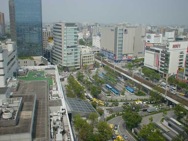
The areas around Kawasaki Station, Musashi-Kosugi Station, Mizonokuchi Station and Shin-Yurigaoka Station are major commercial districts, housing numerous corporate offices and shopping centers.
Fujitsu's Main Branch is located in Nakahara-ku. It was formerly Fujitsu's headquarters.
Culture and sights
Temples and shrines

- Jōraku Temple (Jōraku-ji)
- Kanayama Shrine: Site of the annual Kanamara Matsuri (Festival Of The Steel Phallus).
- Kawasaki Daishi (Heiken-ji). A Buddhist temple in the Kawasaki district. It is the second most visited temple in the Kantō region
- Kotohira Shrine (Kotohira-jinja)
- Mikawari Fudō shrine
- Shinkō Temple (Shinkō-ji) in the spring and autumn garden (Shunjū-en)
- Takaishi Shrine (Takaishi-jinja)
- Tenshōkō daijin shrine (Tenshōkō daijin)
Museums and galleries


- Fujiko F. Fujio Museum: also known as Doraemon museum, opened on September 3, 2011, in Tama-ku Ward.
- Kawasaki City Museum
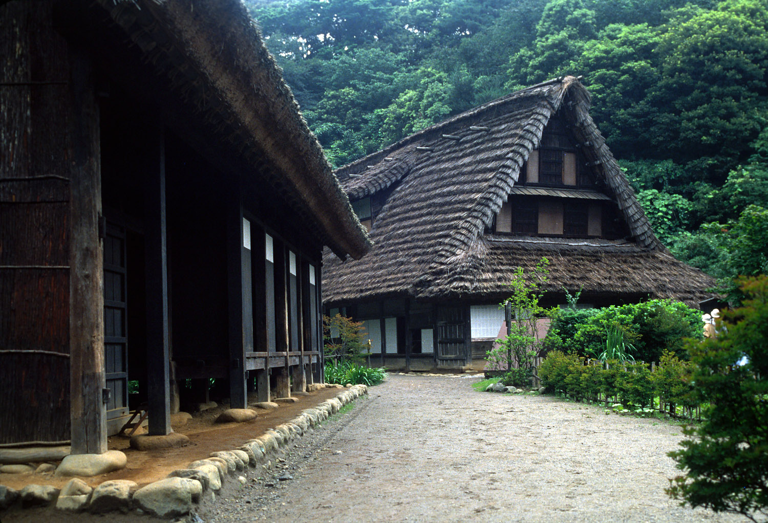
- Nihon Minka-en Open Air Museum (Tama District): with minka traditional farmhouses from different regions of Japan.
- Taro Okamoto Museum of Art
- Railway and bus museum
- Toshiba Museum
Music
- CLUB CITTA
- Muza Kawasaki Symphony Hall - home of the Tokyo Symphony Orchestra
- Yomiuri-Land EAST (Open Air Music Theater)
Recreational facilities
- Kawasaki Racecourse
- Keirin cycle track Kawasaki
- Kawasaki Marien (leisure center)
- Yomiuri Land
Parks
- Ikuta green space (Ikuta ryokuchi)
- Todoroki Ryokuchi: athletic park
- Yumemigasaki Zoo (Yumemigasaki dōbutsu kōen)
Regular events
- Daruma market in Shimo-Asao
- In Unity
- Kanamara Matsuri
- Kawasaki Citizens' Festival
- Kawasaki fantasy night
- Kawasaki Robot Congress
- Sannō festival at the Inage shrine
- Shin-Yuri art festival
- Tamagawa fireworks display
Places of interest
- Kawasaki Warehouse: An amusement arcade whose aesthetic is inspired by the Kowloon Walled City.
- Koreatown: eastern Kawasaki has the second largest concentration of Koreans in Japan, after Osaka. In 1997 it became the first municipality to allow non-Japanese nationals to take civil service employment.
- Nakagawa stable: stable of professional sumo wrestler
Transportation
Railway stations
; East Japan Railway Company : Tōkaidō Main Line :* - - : Keihin-Tōhoku Line :* - Kawasaki - : Nambu Line :* Main Line : Kawasaki - - (Yakō Station is in Tsurumi-ku, Yokohama) - - - - - - - - - - - - - - :* Branch Line : Shitte - - - : Tsurumi Line :* Main Line : - - Hama-Kawasaki - - :* Ōkawa Branch : - : Yokosuka Line, Shōnan-Shinjuku Line :* - Musashi-Kosugi - - ; Odakyu Electric Railway : Odakyū Line :* - - - - - - - : Tama Line :* Shin-Yurigaoka - - - - - ; Keio Corporation : Sagamihara Line :* - - - (Keiō-Yomiuri-Land Station and Inagi Station are in Inagi, Tokyo.) - ; Keikyu Corporation : Keikyū Main Line :* - Hatchōnawate - - : Daishi Line :* Keikyū Kawasaki - - - - - - ; Tokyu Corporation : Tōyoko Line :* - - Musashi-Kosugi - - : Meguro Line :* - Shin-Maruko - Musashi-Kosugi - Motosumiyoshi - : Den-en-toshi Line :* - - - - - - - - : Ōimachi Line :* - Futako-Shinchi - Takatsu - Mizonokuchi
Highways


; Expressway :* Tōmei Expressway is a north-south expressway running from Tokyo to Nagoya and in central area. Tōmei-Kawasaki Interchange is served from Kawasaki. :* Daisan Keihin Road is a north-south expressway running from Tokyo to Hodogaya-ku, Yokohama and in central area. Keihin-Kawasaki Interchange is served from Kawasaki. :* Shuto Expressway Route K1 (Yokohane Route) is a north-south expressway running from Shuto Expressway Route 1 to Shuto Expressway Route K3 (Kariba Route) and in southern area. Daishi Interchange, Hama-Kawasaki Interchange, and Asada Interchange are served from Kawasaki. :* Bayshore Route is a north-south expressway running from Kanazawa-ku, Yokohama to Ichikawa, Chiba and in southern area. Ukishima Interchange and Higashi-Ōgishima Interchange are served from Kawasaki. :* Shuto Expressway Route K6 (Kawasaki Route) is an expressway in southern area. Daishi Interchange, Tonomachi Interchange, and Ukishima Interchange are served from Kawasaki. :* Tokyo Bay Aqua-Line is an expressway across Tokyo Bay from Kawasaki-ku, Kawasaki to Kisarazu, Chiba. Ukishima Interchange is served from Kawasaki.
; National Route :* National Route 1 and 15 are north-south highways running in southern area. Due to elongated territory from east to west, these highways run short length in Kawasaki. :* Japan National Route 246 is a north-south highways running in central area. It also runs short length in Kawasaki. :* Japan National Route 132 is short highway running in southern area. It bounds National Route 15 and port of kawasaki. :* Japan National Route 357 is an industrial highway in southern area. It runs only in Higashi-Ōgishima Island in Kawasaki. :* Japan National Route 409 is a highway running from Takatsu-ku, Kawasaki to Narita, Chiba. It bounds central area and downtown area in Kawasaki.
International relations
Twin cities
Kawasaki is twinned with the following cities in Japan and worldwide.
Domestic friendship cities
- Nagano Prefecture Fujimi, Nagano, since April 22, 1993
- Okinawa Prefecture Naha, Okinawa, since May 20, 1996
- Hokkaido Nakashibetsu, Hokkaido, since July 9, 1992
International
- USA Baltimore, Maryland, United States, since June 14, 1979
- VIE Bà Rịa–Vũng Tàu province, Vietnam, since September 15, 2012
- KOR Bucheon, Gyeonggi Province, South Korea, since October 21, 1996
- DEU Lübeck, Germany, since May 12, 1992
- USA Milwaukee, Wisconsin, United States, since June 20, 1993
- CRO Rijeka, Croatia, since June 23, 1977
- AUT Salzburg, Austria, since April 17, 1992
- UK Sheffield, United Kingdom, since July 30, 1990
- CHN Shenyang, Liaoning, China, since, August 18, 1981
- AUS Wollongong, New South Wales, Australia, since May 18, 1988
Friendship ports
- VIE Da Nang, Vietnam, since January 24, 1994
Notable people from Kawasaki
- Koji Doi, professional wrestler
- Tomohiro Ishii, professional wrestler
- Osamu Kido, professional wrestler
- Kaoru Mitoma, footballer
- Michael Nakazawa, professional wrestler
- Yui Niitsu, member of music duo Rythem
- Hajime Ohara, professional wrestler
- Yuto Ozeki, footballer
- Kazuhiro Tamura, professional wrestler
- Ao Tanaka, footballer
- Natsuki Taiyo, professional wrestler
- Natsuko Tora, professional wrestler
- Yuyu-uta, YouTuber, entertainer, and musician
Notes
References
References
- (September 1, 2015). "Population News of Major Cities". Statistical Information Division, Policy Bureau, City of Yokohama.
- "Kawasaki Station {{!}} Japan Rail Pass".
- Stadt Kawasaki: [http://www.city.kawasaki.jp/miryoku/category/63-1-0-0-0-0-0-0-0-0.html Profil, 8. HISTORY einfach (Zeittafel zur Stadtgeschichte)]
- "総務省|一般戦災死没者の追悼|川崎市における戦災の状況(神奈川県)".
- 三国, 恵子. "川崎市の在日韓国・朝鮮人 - 集住過程と人口".
- "Worldwide Uchinanchu".
- (2023-09-25). "故郷への思いを紡いで100年~川崎沖縄県人会~".
- "総務省|一般戦災死没者の追悼|川崎市における戦災の状況(神奈川県)".
- "Kawasaki climate: Weather Kawasaki & temperature by month".
- [https://www.citypopulation.de/en/japan/kanagawa/ Kawasaki population statistics (1995-2020)]
- (28 October 2013). "Suga downplays LDP loss in Kawasaki poll".
- link. (22 October 2017)
- "Kobe, Kawasaki mayors re-elected - The Mainichi".
- 日本放送協会. "川崎市議選 統一地方選挙2023|NHK選挙WEB".
- http://search.japantimes.co.jp/cgi-bin/nn20080620a4.html {{dead link. (January 2020)
- Präfektur Kanagawa, Präfekturparlament: [http://www.pref.kanagawa.jp/cnt/gikai/p80275.html Abgeordnete nach Wahlkreis], retrieved 22 May 2019.
- 神奈川県. "神奈川県議会 議員の紹介 選挙区でさがす".
- (2022-11-28). "衆議院小選挙区の区割りが変更されました(令和4年)".
- 日本放送協会. "衆議院選挙2021 神奈川(横浜・川崎など)開票速報・選挙結果 小選挙区 NHK".
- Nagatsuka, Kaz. (2017-01-29). "Kawasaki Stadium stirs fond recollection of legendary games".
- [http://www.kawasakikeirin.com/ Kawasaki Keirin]
- "Kawasaki Keiba".
- "[http://www.sigma-photo.co.jp/english/company/overview.html Company Summary]." [[Sigma Corporation]]. Retrieved on September 28, 2015.
- "[http://www.fujitsu.com/global/contact/ Contact]." ''[[Fujitsu]]''. Retrieved on February 4, 2009.
- "[https://web.archive.org/web/19980119155801/http://www.fujitsu.co.jp/hypertext/About_fujitsu/Profile-e.html Company Profile]." ''[[Fujitsu]]''. January 19, 1998. Retrieved on May 19, 2009.
- "fujiko-museum". fujiko-museum.
- (29 August 2011). "Anime star Doraemon to have own museum". The Independent.
- (1 October 2013). "Arcade brings Kowloon Walled City back from the dead ... in Japan". South China Morning Post.
- "Baltimore City Mayor's Office of International and Immigrant Affairs - Sister Cities Program".
This article was imported from Wikipedia and is available under the Creative Commons Attribution-ShareAlike 4.0 License. Content has been adapted to SurfDoc format. Original contributors can be found on the article history page.
Ask Mako anything about Kawasaki, Kanagawa — get instant answers, deeper analysis, and related topics.
Research with MakoFree with your Surf account
Create a free account to save articles, ask Mako questions, and organize your research.
Sign up freeThis content may have been generated or modified by AI. CloudSurf Software LLC is not responsible for the accuracy, completeness, or reliability of AI-generated content. Always verify important information from primary sources.
Report