From Surf Wiki (app.surf) — the open knowledge base
Kathmandu Valley
Valley and proposed territory in Nepal

Valley and proposed territory in Nepal
| Field | Value |
|---|---|
| WHS | Kathmandu Valley, Nepa Valley |
| image | Kathmandu,_Nepal.JPG |
| image_upright | 1.2 |
| caption | Kathmandu Valley seen from the space by the NASA Earth Observatory |
| location | Bagmati Province, Nepal |
| criteria | (iii), (iv), (vi) |
| ID | 121bis |
| coordinates | |
| year | 1979 |
| extension | 2006 |
| danger | 2003–2007 |
| area | 665 km2 |
| locmapin | Kathmandu#Nepal Bagmati Province#Nepal |
The Kathmandu Valley (), also known as the Nepal Valley or Nepa Valley (, Nepal Bhasa: 𑐣𑐾𑐥𑐵𑑅 𑐐𑐵𑑅, नेपाः गाः), National Capital Area, is a bowl-shaped valley located in the Himalayan mountains of Nepal. It lies at the crossroads of ancient civilizations of the Indian subcontinent and the broader Asian continent, and has at least 130 important monuments, including several pilgrimage sites for Hindus and Buddhists. The valley holds seven World Heritage Sites within it.
The Kathmandu Valley is the most developed and the largest urban agglomeration in Nepal with a population of about 5 million people. The urban agglomeration of Kathmandu Valley includes the cities of Kathmandu, Lalitpur, Bhaktapur, Changunarayan, Budhanilkantha, Tarakeshwar, Gokarneshwar, Suryabinayak, Tokha, Kirtipur, Madhyapur Thimi, and others. The majority of offices and headquarters are located in the valley, making it the economic hub of Nepal. It is popular with tourists for its unique architecture, and rich culture which includes the highest number of jatras (festivals) in Nepal. Kathmandu Valley itself was referred to as "Nepal Proper" by British historians. As per the World Bank, the Kathmandu Valley was one of the fastest growing metropolitan areas in South Asia with 2.5 million population by 2010 and an annual growth rate of 4%.
In 2015, Kathmandu Valley was hit by the April 2015 Nepal earthquake. The earthquake caused thousands of deaths and the destruction of many infrastructure across the Kathmandu Valley, which included the towns of Lalitpur, Kirtipur, Madhyapur Thimi, Changunarayan, and Bhaktapur. Kathmandu is also the largest city in the Himalayan hill region.
Etymology
Historically, the valley and adjoining areas made up a confederation known as the Nepal Mandala. Until the 15th century, Bhaktapur was its capital, when two other capitals, Kathmandu and Patan, were established. Until the 1960s, the Kathmandu Valley was known as the Nepala Valley or Nepa Valley. In 1961 the valley was listed as Kathmandu District, which began referring to the valley as Kathmandu Valley. The term Nepa Valley is still used among Newar people and local governments, while senior citizens still tend to refer to the valley as Nepal. The term Swaniga (Nepal Bhasa: 𑐳𑑂𑐰𑐣𑐶𑐐𑑅, स्वनिगः) is used to refer to three cities namely Yén (Kathmandu), Yala (Lalitpur) and Khwapa (Bhaktapur)
The Pahari name Kathmandu comes from a structure in the Durbar Square called by the Sanskrit name Kāsṣtha mandapa "Wooden shelter". This unique temple, also known as the Maru Sattal, was built in 1596 by King Lakshmi Narasimha Malla. The entire structure contained no iron nails or supports and was made entirely from wood. Legend has it that the timber used for this two-story pagoda was obtained from a single tree.
History
The Kathmandu Valley may have been inhabited as early as 300 BCE, since the oldest known objects in the valley date to a few hundred years BCE. The earliest known inscription is dated 185 CE. The oldest firmly dated building in the earthquake-prone valley is over 2,000 years old. Four stupas around the city of Patan that are said to have been erected by Charumati, a purported daughter of the Maurya emperor Ashoka, in the third century BCE, attest to the ancient history present within the valley. As with the tales of the Buddha's visit, there is no evidence supporting Ashok's visit, but the stupas probably date to that century. The Licchavis, whose earliest inscriptions date to 464, were the next rulers of the valley and had close ties with the Gupta Empire of India. The Mallas ruled the Kathmandu Valley and the surrounding area from the 12th until the 18th century CE, when the Shah dynasty of the Gorkha Kingdom under Prithvi Narayan Shah conquered the valley as he created present-day Nepal. His victory in the Battle of Kirtipur was the beginning of his conquest of the valley.
Newars
The Newars are the indigenous inhabitants and the creators of the historic civilization of the valley. Their language is today known as Nepal Bhasa. They are understood to be the descendants of the various ethnic and racial groups that have inhabited and ruled the valley in the two-millennium history of the place. Scholars have also described the Newars as a nation. They have developed a division of labour and a sophisticated urban civilization not seen elsewhere in the Himalayan foothills. They are known for their contributions to art, sculpture, architecture, culture, literature, music, industry, trade, agriculture and cuisine, and have left their mark on the art of Central Asia.
Newa architecture consists of the pagoda, stupa, shikhara, chaitya and other styles. The valley's trademark is the multiple-roofed pagoda which may have originated in this area and spread to India, China, Indochina and Japan. The most famous artisan who influenced stylistic developments in China and Tibet was Araniko, a Newar who traveled to the court of Kublai Khan in the 13th century AD. He is known for building the white stupa at the Miaoying Temple in Beijing. At present, people from other parts of Nepal tend to migrate to the valley for a better life due to its high level of cultural and economic development. Even with urbanization taking place, the Newars have sustained their culture in the Kathmandu Valley.
Mythology

According to Swayambhu Puran, the Kathmandu Valley was once a lake, deemed by scientists as Paleo Kathmandu Lake. The hill where the Swayambu Stupa rests had lotus plants with flowers in bloom. One story says that the God Manjusri cut a gorge at a valley called Kashapaal (later called Chobhar) with a sword called Chandrahrasha and drained away the waters in order to establish a habitable land.
According to Gopal Banshawali, Krishna cut the gorge with his Sudarshana Chakra to let the water out. He then handed the drained valley to the Gopal Vansi people, who were nomadic cow herders.
Geography

Kathmandu Valley is bowl-shaped. Its central lower part stands at 1425 m. Kathmandu Valley is surrounded by five mountain ranges: Shivapuri hills (at an elevation of 2732 m), Phulchowki (2762 m), Nagarjun (2128 m), Champadevi (2278 m) and Chandragiri (2551 m). The major river flowing through the Kathmandu Valley is the Bagmati River. The valley is made up of the Kathmandu District, Lalitpur District and Bhaktapur District covering an area of 220 sqmi. The valley consists of the municipal areas of Kathmandu, Patan, Bhaktapur, Kirtipur and Madhyapur Thimi; the remaining area is made up of a number of municipalities and rural municipalities in Lalitpur district. The valley is a cultural and political hub of Nepal. The Kathmandu Valley was accorded the status of a World Heritage Site by UNESCO in the year 1979.
Notable areas


This is an incomplete alphabetical list of notable temples and monuments in Kathmandu Valley. Seven of these are designated as UNESCO World Heritage Sites.
- Bhaktapur District
- Balkumari temple
- Bhaktapur Durbar Square (a UNESCO World Heritage Site)
- Changu Narayan Temple (a UNESCO World Heritage Site)
- Doleshwor Mahadeva Temple
- Kailashnath Mahadev Statue
- Pujarimath Museum
- Suryavinayak Temple
- Kathmandu District
- Aakash Bhairav Temple
- Ashok Binayak Temple
- Aditnath Temple
- Ajima Temple
- Bagh Bhairab Temple
- Bajrayogini Temple
- Boudhanath Stupa (a UNESCO World Heritage Site)
- Budhanilkantha Temple
- Chandra Binayak Temple
- Chandragiri Hill
- Dakshinkali Temple
- Dharahara
- Garden of Dreams
- Ghanta Ghar
- Gokarneshwor Mahadev temple
- Guhyeshwari Temple
- Jal Binayak Temple
- Kasthamandap
- Kathmandu Durbar Square (a UNESCO World Heritage Site)
- Kopan Monastery
- Narayanhiti Palace
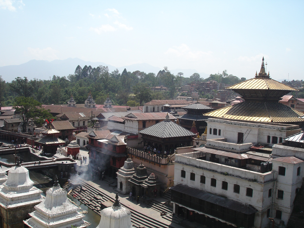
- Pashupatinath Temple (a UNESCO World Heritage Site)
- Ranipokhari Pond
- Ratna Park
- Seto Machhendranath Temple
- Shiva Parvati Temple
- Shivapuri Nagarjun National Park
- Swayambhunath Stupa Complex (a UNESCO World Heritage Site)
- Taleju Temple
- Taragaon Museum
- Taudaha Lake
- Thrangu Tashi Yangtse Monastery
- Lalitpur District
- Balkumari temple
- Hiranya Varna Mahavihar Temple
- Kumbheshwar Temple Complex
- Mahabouddha Temple
- Nagdaha lake
- Patan Durbar Square (a UNESCO World Heritage Site)
- Rato Macchindranath Temple, Bungmati
Present

This valley hosts a UNESCO World Heritage Site with seven preserved locations: the centers of the three primary cities, Kathmandu Hanuman Dhoka, Patan Durbar Square and Bhaktapur Durbar Square, the two most important Buddhist stupas, Swayambhunath and Boudhanath and two famous Hindu shrines, Pashupatinath temple and Changu Narayan. In 2003, UNESCO listed the sites as being "endangered" out of concern for the ongoing loss of authenticity and the outstanding universal value of the cultural property. The endangered status was lifted in 2007.
In the past, Tibetan Buddhist Masters including Marpa, Milarepa, Rwa Lotsava, Ras Chungpa, Dharmasvamin, XIII Karmapa, 16th Karmapa, XVI Karmapa and several others visited and travelled in the Kathmandu Valley. However, the largest group of Tibetans came in the 1960s. Many settled around the Swayambhunath and Boudhanath Stupas. Many other famous Lamas known throughout the world have their Buddhist monasteries and centers in the Kathmandu Valley.
The 1500-year history of funerary architecture in the valley provides some of the finest examples of stone architecture found in the subcontinent. A caitya is placed in almost all courtyards in cities like Patan. Stone inscriptions in the Kathmandu Valley are important sources for the history of Nepal.
Demographics
Kathmandu Valley has total population of 2,996,341.
Kathmandu (National Capital Area)
In 2015, the Government of Nepal proposed to develop Kathmandu valley as a separate national capital territory and not a part of Bagmati Province.
Kathmandu Valley consists 3 Districts of Bagmati Province whose total population is 2,996,341 and total area is 933.73 km2
| District | Area | Population (2021) | Kathmandu NCT | 933.73 km2 | 2,996,341 | ||
|---|---|---|---|---|---|---|---|
| Kathmandu District | 413.69 km2 | 2,017,532 | |||||
| Bhaktapur District | 123.12 km2 | 430,408 | |||||
| Lalitpur District | 396.92 km2 | 548,401 |
Major cities
Cities and towns with 75,000+ population of Kathmandu Valley as per 2021 Nepal census.
| Name | District | Population (2021) | Area (km2) | Density (/km2) |
|---|---|---|---|---|
| Kathmandu | Kathmandu District | 845,767 | 49.45 | |
| Lalitpur | Lalitpur District | 299,843 | 36.12 | |
| Budhanilkantha | Kathmandu District | 179,688 | 34.8 | |
| Tarakeshwar | Kathmandu District | 151,508 | 54.95 | |
| Gokarneshwar | Kathmandu District | 151,200 | 58.5 | |
| Suryabinayak | Bhaktapur District | 137,971 | 42.45 | |
| Chandragiri | Kathmandu District | 136,928 | 43.9 | |
| Tokha | Kathmandu District | 135,741 | 17.11 | |
| Kageshwari-Manohara | Kathmandu District | 133,327 | 27.38 | |
| Madhyapur Thimi | Bhaktapur District | 119,955 | 11.47 | |
| Mahalaxmi | Lalitpur District | 118,710 | 26.51 | |
| Nagarjun | Kathmandu District | 115,507 | 29.85 | |
| Godawari | Lalitpur District | 100,972 | 96.11 | |
| Changunarayan | Bhaktapur District | 88,612 | 62.98 | |
| Kirtipur | Kathmandu District | 81,782 | 14.76 | |
| Bhaktapur | Bhaktapur District | 78,854 | 6.89 | |
| Dakshinkali | Kathmandu District | |||
| Shankharapur | Kathmandu District | |||
| Konjyoson Rural Municipality | Lalitpur District | |||
| Bagmati Rural Municipality | Lalitpur District | |||
| Mahankal Rural Municipality | Lalitpur District |
References
References
- [https://whc.unesco.org/en/news/356/ Royal Palaces of Abomey and Kathmandu removed from Danger List] {{Webarchive. link. (6 August 2022 at [[UNESCO]] website)
- Centre, UNESCO World Heritage. "Kathmandu Valley".
- "Archived copy".
- "Managing Nepal's Urban Transition". World Bank.
- "Nepal Disaster Risk Reduction Portal". Government of Nepal.
- [[Mary Shepherd Slusser. Slusser, M.]] (1982). ''Nepal Mandala: A Cultural Study of the Kathmandu Valley.'' Princeton University. {{ISBN. 978-0-691-03128-6. Page vii.
- (2006). "नेपालमण्डल". Nepal Mandal Anusandhan Guthi.
- (2006). "नेपालमण्डल (नेपाली अनुवाद)". Nepal Mandal Anusandhan Guthi.
- "'राजधानी प्रदेश' र 'नेवा राज्य' : केही भ्रमको खण्डन".
- "Celestial Advice".
- "नेपालको जिल्ला प्रशासन पुनर्गठनको रिपोर्ट २०१३". Government of Nepal.
- "Save Nepa Valley Movement Homepage".
- (2018). "भक्तपुर नगरपालिका स्थानीय पाठ्यक्रम २०७५". Bhaktapur Municipality.
- "'राजधानी प्रदेश' र 'नेवा राज्य' : केही भ्रमको खण्डन".
- Rajendra S. Khadka ''Travelers' Tales Nepal''
- von Furer-Haimendorf, Christoph. (1956). "Elements of Newar Social Structure". Royal Anthropological Institute of Great Britain and Ireland.
- "Mesocosm".
- (2013-06-27). "CHAITYA HALLS". Cambridge University Press.
- (8 September 1964). "Area handbook for Nepal (with Sikkim and Bhutan)". Washington, For sale by the Supt. of Docs., U.S. Govt. Print. Off..
- (1994). "Nepal: A Guide to the Art and Architecture of the Kathmandu Valley". Kiscadale.
- (2008-02-15). "Middle to late Pleistocene climatic and depositional environmental changes recorded in the drilled core of lacustrine sediments in the Kathmandu Valley, central Nepal". Himalayan Journal of Sciences.
- (2023-06-30). "In-situ Radiometric Assessment of UNESCO World Heritage Sites in Kathmandu Valley of Nepal Using Gamma Ray Spectrometry". Jordan Journal of Physics.
- "Places to see UNESCO World Heritage Sites".
- "UNESCO World Heritage Centre - State of Conservation (SOC 2003) Kathmandu Valley (Nepal)".
- [http://www.lumbini.org.uk/Tibetan_Buddhism_kathmandu.htm Observation on the influence of Tibetan Buddhism in the Kathmandu Valley:] {{webarchive. link. (20 November 2008)
- Gutschow, Niels (1997). ''The Nepalese Caitya: 1500 Years of Buddhist Votive Architecture in the Kathmandu Valley.'' {{ISBN. 978-3-930698-75-2. Pages 30-31.
- (2011). "Census Data".
- (2016). "Call for integrated development of Kathmandu Valley". My Republica.
- (2012). "Road Map for Making Kathmandu Valley Development Concept Plan Risk Sensitive ...". UNDP, Nepal.
- (2015). "Valley envisioned as national capital of federal Nepal". The Halayan.
- "Kathmandu Metropolitan City | Government of Nepal".
- "Lalitpur Metropolitan City | Government of Nepal".
- "Budhanilkantha Municipality Office | Government of Nepal".
- "Tarakeshwor Municipality | Office of the Municipal Executive".
- "Gokarneshwor Municipality | Municipality OfficeBagmati Pradesh, JorpatiKathmandu, Nepal".
This article was imported from Wikipedia and is available under the Creative Commons Attribution-ShareAlike 4.0 License. Content has been adapted to SurfDoc format. Original contributors can be found on the article history page.
Ask Mako anything about Kathmandu Valley — get instant answers, deeper analysis, and related topics.
Research with MakoFree with your Surf account
Create a free account to save articles, ask Mako questions, and organize your research.
Sign up freeThis content may have been generated or modified by AI. CloudSurf Software LLC is not responsible for the accuracy, completeness, or reliability of AI-generated content. Always verify important information from primary sources.
Report