From Surf Wiki (app.surf) — the open knowledge base
Kapoho, Hawaii
Former community on the island of Hawaii

Former community on the island of Hawaii
Kapoho is a now-uninhabited unincorporated area in Puna district, Hawaii County, Hawaii, US, located near the eastern tip of the island of Hawaii, in the easternmost subaerial end of the graben overlying Kīlauea's east rift zone. Originally destroyed by an eruption of Kīlauea in 1960, it was rebuilt as a community of private homes and vacation rentals. The town was again destroyed by lava during the 2018 lower Puna eruption, this time with the bay largely buried by lava as well.
Eruption of January 1960
On January 12, 1960, residents of Kapoho experienced over 1,000 small earthquakes shaking the area. Deep cracks opened up in the street, and there are historic photos of residents inspecting the damage.
The eruption began on the night of the 13th, spilling lava out in the middle of a sugar cane field just above Kapoho. Although the main flow of lava flowed into the ocean, a slow-moving offshoot crept towards the town of Kapoho. Despite frantic efforts to divert the flow with earthen barricades or to harden it by spraying water on it, on January 28 the flow entered and buried the town. Nearly 100 homes and businesses as well as a hot spring resort were destroyed. The Cape Kumukahi Light east of the town was spared and continues in operation, but the keeper's dwellings were destroyed.
1960 to 2018

There was no lava activity in Kapoho for close to 60 years. The natural tide pools, black sand beach, and warm hot springs transformed Kapoho into an attractive spot to live and for tourists to visit. Owing to these two factors, despite being in a very high-risk lava flow hazard zone (zone 1, the highest risk zone), Kapoho became the most expensive area to live in Puna, with many homes costing over $1,000,000.
2018 lower Puna eruption
Main article: 2018 lower Puna eruption
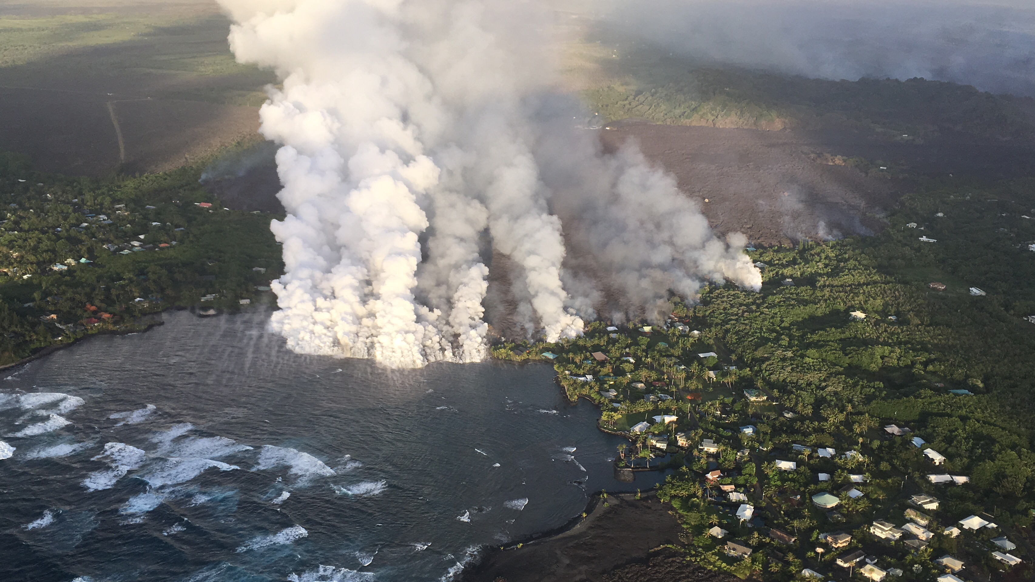
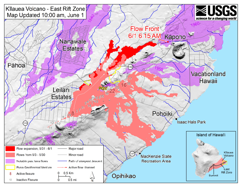
The 2018 lower Puna eruption interrupted electric power to Kapoho in late May and closed the main road to the rest of the island. On May 30, residents were urged to evacuate. On June 1, the lava flow front entered Kapoho on top of the 1960 flow and then took a turn to the south. On June 2, 2018, the Green Lake (Ka Wai o Pele) was destroyed when lava flows boiled it away and completely filled the entire basin. The flow entered the ocean at Kapoho Bay on June 4 on a half-mile-wide (800 m) front. An unknown number of homes were destroyed by the lava on June 4, but the majority were still standing. By June 5, the lava flow had built a lava delta that extended nearly 3700 ft into the bay. Hawaiʻi County officials indicated that hundreds of homes in the subdivisions of Vacationland Hawaii and Kapoho Beach Lots were destroyed by the rapidly advancing lava flow. Hawaii Island Mayor Harry Kim's house, which he had purchased in 1971 as a second residence, was among the hundreds of houses destroyed. Over the next few days, the entirety of the bay was filled in with lava, and on June 6, Hawaii County Civil Defense reported that the few homes remaining in Vacationland had been wiped out. An adjacent subdivision, the gated Kapoho Beach Lots, also suffered lava inundation and was largely covered, along with the Kapoho tide pools, Kapoho Bay, and the nearby Champagne Ponds.
By the end of June, about 520 acre of new land had been created along with miles of new coastline.
References
References
- "1960 Kapoho Eruption provided lesson in Kīlauea behavior". [[United States Geological Survey]].
- Thomas L. Wright. "Map Showing Lava-Flow Hazard Zones, Island of Hawaii".
- "96778 Real Estate & Homes for Sale – realtor.com®".
- "Photo and Video Chronology". Hawaiian Volcano Observatory – U.S. Geological Survey – U.S. Department of the Interior.
- Gebers, Samie. (March 2025). "Lava destroys, damages hundreds of power poles in lower Puna". [[Hawaii News Now]] }}{{Dead link.
- "East Rift Zone Eruption – 5/29/18 6:00 PM". [[County of Hawaii]].
- "East Rift Zone Eruption – 5/30/18 6:00 AM". [[County of Hawaii]].
- (June 1, 2018). "Kilauea Volcano – East Rift Zone, map updated 10:00am, June 1". [[United States Geological Survey]].
- Peterkin, Olivia. (June 4, 2018). "Into thin air: Lava flows claim Hawaii's largest lake in a matter of hours". [[Hawaii News Now]].
- [https://www.planet.com/stories/green-lake-hawai-i-1bQ-PjpmR Comparison of satellite images on February 19 and August 6, 2018] (Planet Labs Inc.)
- (19 July 2015). "Ka Wai O Pele (the water of Pele)".
- (4 June 2018). "Managing Director: Some residents defying voluntary evacuation order in Kapoho – Hawaii Tribune-Herald".
- "County of Hawaii – Civil Defense Alerts and Information – East Rift Zone Eruption: MON, 6/4/18, 11:30AM – Update 3".
- [https://volcanoes.usgs.gov/observatories/hvo/maps_uploads/image-467.jpg][[United States Geological Service]] map
- (3 June 2018). "Fissure 8 lava flow moving north; laze creating plume at Kapoho Bay".
- (2018-06-05). "River of lava claims hundreds more homes". Hawaii News Now.
- . (25 February 2019). ["Kapoho Bay, playground for Big Islanders and many others, is lost to lava"](http://www.hawaiinewsnow.com/story/38356471/kapoho-bay-playground-for-big-islanders-and-many-others-is-lost-to-lava). *Hawaii News Now*.
- (4 June 2018). "Hundreds of homes in peril as Kilauea lava flow nears Kapoho Beach Lots, Vacationland - Hawaii Tribune-Herald".
- (5 June 2018). "Big Isle mayor's home destroyed by lava, county confirms".
- Park, Madison. (6 June 2018). "Lava filled up this Hawaiian bay and destroyed what could be hundreds of homes". CNN.
- (6 June 2018). "Vacationland completely wiped out by lava". Hawaii Tribune Herald.
- "VIDEO: 12pm Eruption Update – Lava Covers Most of Kapoho".
- (5 June 2018). "Almost all of Kapoho Beach Lots, Vacationland consumed by lava".
- [https://volcanoes.usgs.gov/observatories/hvo/maps_uploads/image-499.jpg US Geological Survey map of Kilauea East Rift Zone, June 30, 2018]
This article was imported from Wikipedia and is available under the Creative Commons Attribution-ShareAlike 4.0 License. Content has been adapted to SurfDoc format. Original contributors can be found on the article history page.
Ask Mako anything about Kapoho, Hawaii — get instant answers, deeper analysis, and related topics.
Research with MakoFree with your Surf account
Create a free account to save articles, ask Mako questions, and organize your research.
Sign up freeThis content may have been generated or modified by AI. CloudSurf Software LLC is not responsible for the accuracy, completeness, or reliability of AI-generated content. Always verify important information from primary sources.
Report