From Surf Wiki (app.surf) — the open knowledge base
Kalmar County
County (län) of Sweden
County (län) of Sweden
| Field | Value |
|---|---|
| official_name | Kalmar County |
| native_name | sv |
| settlement_type | County of Sweden |
| image_flag | Kalmar län vapenflagga.svg |
| flag_size | 100px |
| image_shield | Kalmar län vapen.svg |
| shield_size | 100px |
| image_map | Kalmar län in Sweden.svg |
| map_caption | Kalmar County in Sweden |
| image_map1 | Sweden Kalmar location map.svg |
| map_caption1 | Location map of Kalmar County in Sweden |
| coordinates | |
| subdivision_type | Country |
| subdivision_name | Sweden |
| established_title | Founded |
| established_date | 1634 |
| seat_type | Capital |
| seat | Kalmar |
| parts_type | Municipalities |
| parts | 12 |
| p1 | Borgholm |
| p2 | Emmaboda |
| p3 | Högsby |
| p4 | Hultsfred |
| p5 | Kalmar |
| p6 | Mönsterås |
| p7 | Mörbylånga |
| p8 | Nybro |
| p9 | Oskarshamn |
| p10 | Torsås |
| p11 | Västervik |
| p12 | Vimmerby |
| leader_party | Liberals |
| leader_title | Governor |
| leader_name | Allan Widman |
| leader_title1 | Council |
| leader_name1 | Region Kalmar County |
| area_total_km2 | 11217.8 |
| area_rank | |
| population_as_of | 31 December 2023 |
| population_footnotes | |
| population_total | 246,667 |
| population_rank | |
| population_density_km2 | auto |
| demographics_type1 | GDP |
| demographics1_footnotes | |
| demographics1_title1 | Total |
| demographics1_info1 | SEK 78 billion |
| €8.377 billion (2015) | |
| timezone1 | CET |
| utc_offset1 | +1 |
| timezone1_DST | CEST |
| utc_offset1_DST | +2 |
| iso_code | SE-H |
| blank_name_sec2 | NUTS Region |
| blank_info_sec2 | |
| website |
€8.377 billion (2015)
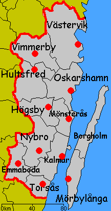
Kalmar County () is a county or län in southern Sweden. It borders the counties of Kronoberg, Jönköping, Blekinge and Östergötland. To the east in the Baltic Sea is the island Gotland.
The counties are mainly administrative units. Geographically Kalmar County covers the eastern part in the Småland province, and the entire island of Öland.
Culture
Much of Öland's present-day landscape known as the Stora Alvaret has been designated as a World Heritage Site by UNESCO. This southern part of Öland is known for a large number of rare species; early Paleolithic settlement at Alby; other prehistoric remains such as the Gettlinge Gravefield and Eketorp Fortress; and the Ottenby Nature Preserve.
Administration
Kalmar County was integrated with Kronoberg County until 1672. Blekinge was a part of Kalmar County between 1680 and 1683, due to the foundation of the naval base at Karlskrona.
The seat of residence for the Governor or Landshövding is Kalmar. The Governor is the head of the County Administrative Board or Länsstyrelse. The County Administrative Board is a Government Agency headed by a Governor. See List of governors of Kalmar County.
Since 1997 the municipalities and the county council have cooperated through the indirectly politically controlled Regional Council of Kalmar County. The regional council represents the municipalities interests in regional growth issues, coordinates infrastructure planning, higher education and common cultural issues, and administers various governmental and EU grants.
Governors
Main article: List of governors of Kalmar County
[[Riksdag]] elections
The table details all Riksdag election results of Kalmar County since the unicameral era began in 1970. The blocs denote which party would support the Prime Minister or the lead opposition party towards the end of the elected parliament.
| Year | Turnout | Votes | V | S | MP | C | L | KD | M | SD | NyD | Left | Right |
|---|---|---|---|---|---|---|---|---|---|---|---|---|---|
| 1970 | 88.6 | 153,510 | 3.5 | 45.0 | 25.4 | 9.6 | 2.7 | 13.4 | 48.6 | 48.4 | |||
| 1973 | 91.2 | 157,126 | 3.9 | 43.9 | 29.9 | 5.5 | 2.4 | 14.3 | 47.7 | 49.7 | |||
| 1976 | 92.3 | 164,975 | 3.2 | 43.3 | 29.6 | 6.7 | 3.2 | 15.1 | 46.6 | 51.4 | |||
| 1979 | 91.3 | 164,457 | 4.0 | 44.1 | 24.0 | 7.1 | 1.9 | 18.6 | 48.1 | 49.8 | |||
| 1982 | 91.7 | 165,881 | 3.8 | 46.1 | 1.3 | 21.7 | 3.9 | 2.3 | 20.8 | 49.9 | 46.4 | ||
| 1985 | 89.9 | 163,808 | 3.8 | 46.0 | 1.3 | 19.2 | 9.8 | 19.8 | 49.8 | 48.8 | |||
| 1988 | 86.6 | 156,667 | 4.5 | 45.4 | 4.3 | 18.1 | 8.1 | 3.5 | 15.9 | 54.2 | 42.1 | ||
| 1991 | 87.2 | 158,445 | 3.8 | 39.6 | 2.7 | 14.4 | 5.8 | 7.9 | 18.2 | 6.9 | 43.4 | 46.4 | |
| 1994 | 87.2 | 158,424 | 5.6 | 47.6 | 4.3 | 13.0 | 4.4 | 4.3 | 19.0 | 1.3 | 57.5 | 40.6 | |
| 1998 | 81.6 | 145,002 | 11.5 | 39.4 | 3.9 | 9.2 | 2.8 | 13.3 | 18.3 | 54.8 | 43.7 | ||
| 2002 | 80.7 | 144,228 | 7.3 | 43.7 | 3.6 | 10.6 | 8.9 | 11.3 | 12.7 | 0.8 | 54.6 | 43.5 | |
| 2006 | 82.2 | 147,531 | 5.0 | 41.4 | 3.9 | 11.1 | 5.2 | 7.1 | 21.3 | 3.2 | 50.2 | 44.7 | |
| 2010 | 85.0 | 154,736 | 5.1 | 35.9 | 5.6 | 8.9 | 5.1 | 6.0 | 26.9 | 5.8 | 46.2 | 46.9 | |
| 2014 | 86.7 | 158,822 | 4.6 | 35.5 | 4.7 | 8.7 | 3.5 | 4.7 | 20.3 | 15.3 | 44.7 | 37.3 | |
| 2018 | 88.1 | 160,864 | 6.1 | 31.2 | 2.9 | 9.8 | 3.8 | 7.2 | 17.2 | 20.6 | 50.0 | 48.8 | |
| 2022 | 86.0 | 163,223 | 4.6 | 31.7 | 3.6 | 6.5 | 3.2 | 7.0 | 17.8 | 24.5 | 46.4 | 52.5 |
Municipalities
On the mainland:
- Emmaboda
- Hultsfred
- Högsby
- Kalmar
- Mönsterås
- Nybro
- Oskarshamn
- Torsås
- Vimmerby
- Västervik On Öland:
- Borgholm
- Mörbylånga
Localities in order of size
The five most populous localities of Kalmar County in 2020:
| # | Locality | Population |
|---|---|---|
| 1 | Kalmar | 41,852 |
| 2 | Västervik | 21,472 |
| 3 | Oskarshamn | 18,921 |
| 4 | Nybro | 13,599 |
| 5 | Vimmerby | 8,231 |
Foreign background
SCB have collected statistics on backgrounds of residents since 2002. These tables consist of all who have two foreign-born parents or are born abroad themselves. The chart lists election years and the last year on record alone.
| Location | 2002 | 2006 | 2010 | 2014 | 2018 | 2019 |
|---|---|---|---|---|---|---|
| Borgholm | 5.3 | 5.7 | 7.2 | 9.1 | 12.3 | 12.4 |
| Emmaboda | 10.2 | 11.9 | 13.6 | 15.8 | 22.3 | 23.4 |
| Hultsfred | 9.3 | 10.6 | 13.2 | 17.6 | 24.6 | 24.7 |
| Högsby | 10.3 | 11.4 | 14.8 | 19.2 | 28.7 | 28.5 |
| Kalmar | 8.9 | 10.3 | 12.1 | 13.9 | 17.1 | 17.9 |
| Mönsterås | 6.8 | 8.4 | 9.1 | 12.3 | 17.1 | 17.3 |
| Mörbylånga | 4.6 | 4.8 | 5.8 | 7.1 | 9.8 | 9.9 |
| Nybro | 9.7 | 10.6 | 12.5 | 15.9 | 21.8 | 22.1 |
| Oskarshamn | 8.8 | 10.2 | 11.9 | 14.1 | 17.9 | 18.3 |
| Torsås | 5.4 | 6.9 | 8.6 | 9.8 | 13.5 | 13.4 |
| Vimmerby | 5.8 | 7.2 | 8.8 | 10.5 | 15.3 | 15.5 |
| Västervik | 7.2 | 8.0 | 9.0 | 10.8 | 13.9 | 14.0 |
| Total | 8.0 | 9.1 | 10.7 | 13.0 | 17.2 | 17.5 |
| Source: SCB |
Heraldry
Main article: Heraldry of Småland
The County of Kalmar was formally granted its arms in 1944. Before this the county carried the arms of Småland and Öland side by side. The current arms is a combination of the arms for Småland and Öland. Blazon: "Quartered, the arms of Småland and Öland"
References and notes
References
- (31 December 2023). "Folkmängd i riket, län och kommuner 31 december 2023 och befolkningsförändringar 2023". [[Statistics Sweden]].
- [http://stats.oecd.org/ Regions and Cities > Regional Statistics > Regional Economy > Regional GDP per Capita], OECD.Stats. Accessed on 16 November 2018.
- "Riksdagsvalet 1970". SCB.
- "Riksdagsvalet 1973". SCB.
- "Riksdagsvalet 1976". SCB.
- "Riksdagsvalet 1979". SCB.
- "Riksdagsvalet 1982". SCB.
- "Riksdagsvalet 1985". SCB.
- "Riksdagsvalet 1988". SCB.
- "Riksdagsvalet 1991". SCB.
- "Riksdagsvalet 1994". SCB.
- "Riksdagsvalet 1998". SCB.
- "Valresultat Riksdag 2002". [[Valmyndigheten]].
- "Allmänna val 17 september 2006". [[Valmyndigheten]].
- "Röster - Val 2010". Valmyndigheten.
- "Röster - Val 2014". Valmyndigheten.
- "Röster - Val 2018". [[Valmyndigheten]].
- "Valpresentation".
- (24 October 2019). "Localities 2018 – population, land area, population density". [[Statistics Sweden]].
- "PxWeb - välj variabler och värden". [[Statistiska Centralbyrån.
This article was imported from Wikipedia and is available under the Creative Commons Attribution-ShareAlike 4.0 License. Content has been adapted to SurfDoc format. Original contributors can be found on the article history page.
Ask Mako anything about Kalmar County — get instant answers, deeper analysis, and related topics.
Research with MakoFree with your Surf account
Create a free account to save articles, ask Mako questions, and organize your research.
Sign up freeThis content may have been generated or modified by AI. CloudSurf Software LLC is not responsible for the accuracy, completeness, or reliability of AI-generated content. Always verify important information from primary sources.
Report